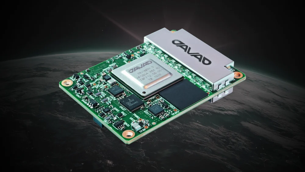
JAVAD GNSS has announced the TR-2S LEO, a compact GNSS OEM board designed and manufactured at the company’s headquarters in San Jose, California. The TR-2S LEO delivers high-precision GNSS positioning for low Earth Orbit (LEO) missions.
Developed for customers requiring high-integrity navigation performance under the demanding conditions of space, the TR-2S LEO integrates radiation-tolerant, space-hardened electronics with patented spoofing and jamming detection to support, secure and protect continuous GNSS operation. The board tracks 874 channels across all major GNSS constellations, enabling robust and real-time position, velocity, time and measurements (PVT) with multi-frequency resilience.
JAVAD GNSS brings more than two decades of flight heritage, with OEM boards deployed on most commercial launch vehicles worldwide, including the Vega program of the European Space Agency (ESA). The company continues to build upon its experience, now with focused concentration on LEO-based applications with technologies like the TR-2S LEO and the SpaceAnt-G3T OEM GNSS antenna. The SpaceAnt-G3T features a stable phase center and is usable for single-, dual- and triple-frequency applications.
“The TR-2S LEO reflects our commitment to delivering mission-critical GNSS solutions engineered and manufactured entirely in the United States,” said Tom Hunter, senior vice president, Aerospace and Defense Solutions at JAVAD GNSS. “As commercial space operations expand, our customers need a navigation platform they can trust — one built on proven flight heritage, radiation-hardened design, and the technical support to see their missions succeed. That’s what we deliver.”
The TR-2S LEO is adaptable to a wide range of commercial launch vehicles, spacecraft and high-dynamic applications.
JAVAD GNSS and ProStar have announced an integrated collaboration for high-precision utility mapping and infrastructure asset tracking. The collaboration features JAVAD GNSS U.S.-made smart antennas and the mobile utility mapping software, PointMan by ProStar.
This strategic partnership expands the reach of both companies and addresses the growing demand for fully integrated and field-ready precision mapping solutions in the utility industry.
The combined solution pairs:
JAVAD GNSS smart antennas, designed and manufactured in the United States, delivering centimeter accuracy, multi-constellation support, and resilience in demanding field conditions.
PointMan by ProStar mobile software, a platform for mapping, visualizing and managing above- and below-ground assets in real time on standard mobile devices.
“Through strategic partnerships with leading hardware manufacturers like JAVAD, we are transforming the utility mapping industry,”said Page Tucker, CEO and founder of ProStar. “We see this as part of a growing trend in the industry where major hardware providers recognize they can create greater value for their customers by bundling our PointMan solutions with their hardware products.”
JAVAD GNSS, a global provider of high-precision GNSS solutions, and Inertial Labs, a VIAVI Solutions Company, have entered a strategic partnership to integrate Inertial Labs’ IMU-P modules with JAVAD’s advanced OEM GNSS receivers. This collaboration introduces a new GNSS+INS platform designed to deliver accuracy, stability and resilience, even in environments where GNSS signals are weak or unavailable.
Central to this advancement is the JAVAD TR-3Si receiver, engineered for compatibility with professional IMU modules. Combined with the advanced IMU-P units, the system is positioned to offer high levels of precision and reliability, supporting mission-critical requirements in aerospace, defense, autonomous vehicles, UAVs, robotics, precision agriculture and other demanding sectors.
Inertial Labs’ IMU-P modules can perform in dynamic settings, providing continuous orientation and acceleration data for sensor fusion. The integration of this inertial technology with JAVAD’s established GNSS systems enhances navigation accuracy and efficiency in both GNSS-accessible and GNSS-denied environments.
JAVAD GNSS is expanding its support for IMU modules and is expected to release further updates on this initiative.
Javad GNSS has released its latest data collection software, Javad Data Collector (JDC). Designed to run seamlessly on any Android device, JDC interfaces effortlessly with the company’s modern line of smart antennas.
JDC features simple, intuitive workflows that require minimal training, making it accessible for users of all skill levels. The software includes a Signal Bar for a quick view of receiver status, ensuring users can easily monitor their equipment’s performance. Additionally, JDC offers easy navigation, allowing users to move through the software with efficiency.
“Our goal with JDC was to create a tool that not only meets but exceeds the needs of our diverse clientele,” said Gary Walker, executive vice president, JAVAD GNSS. “We understand the demands of the full spectrum ranging from the individual surveyor to larger surveying firms, construction and engineering firms, as well as government entities. JDC is designed to streamline their operations, making it easier to deploy and manage receivers across teams of any size with minimal training.”
JDC is available for download through the company’s official website. Customers can evaluate the full functionality of JDC with limited point storage and may request a license when ready to integrate it into their workflow.
Septentrio has been working on port automation projects with Kalmar, a Finnish company that offers a wide range of cargo handling solutions and services to ports, terminals, distribution centers and heavy industry. I discussed this collaboration with Stef van der Loo, market access manager at Septentrio. Following are excerpts of our conversation. For a much longer version, click here.
What are the challenges operating in a port?
In a container terminal or port, everything is interconnected and, therefore, complex. Lately, GNSS has become more popular, especially when coupled with inertial navigation, because the technology has become more capable of delivering centimeter-level accuracy even in challenging environments where the line-of-sight to GNSS satellites may be partially blocked by containers or structures.
What drives higher accuracy?
this Kalmar container handler has a Septentrio high-accuracy GNSS/INS receiver and an inertial system, which operate in challenging environments of low satellite visibility. (Image: Kalmar)
Every year, every terminal stacks a certain number of containers, but not all the information about them is given to the terminal operating system (TOS) automatically. Sometimes, operators must search for misplaced containers, which may require stopping operations and deploying additional personnel. Additionally, it is not very safe to go into these yards. This is one reason why ports began to deploy positioning systems. However, ten years ago, with meter accuracy, they were failing all the time. Now, improvements in the technology have enabled GNSS to become fit for the challenge. In terminals, you can use GNSS or INS systems for vehicle traffic management, autonomous vehicles and tasks, or to get the position of a container.
For example, when a reach stacker reaches into a stack and locks a container in place, it’s crucial to have a very reliable centimeter-level position. Errors grow as the data is processed from the control systems to the TOS. To know for certain the position of a container when it was placed in a stack errors must not exceed half a meter. Therefore, the reliability and accuracy of the GNSS/INS is crucial for container positioning.
Do you buy the IMUs and do all the integration?
We buy the IMUs mostly from Analog Devices. The integrated inertial navigation solution is our own. We focus on inertial navigation in several markets — including logistics, autonomous mining, and agricultural robotics.
What is the division of labor between you and Kalmar?
Kalmar is both an OEM and an integrator. They are a guru for the automation of logistics terminals. We work with them mainly as an integrator. They will go to a terminal, like other integrators, and install the systems and other equipment. Kalmar built a whole sensor stack with all types of sensors and integrated this in their packages, such as SmartPort. With a train-the-trainer principle, our engineers trained Kalmar employees, so they have first line control of the installations and troubleshooting. Then we are ready to support them where we can. We have a continuous feedback loop with several logistics customers for suggestions and product recommendations for the evolution of our products and services for this segment.
Straddling containers
JAVAD GNSS
Straddle carrier in operation equipped with DELTA-3S. (Image: Canva)
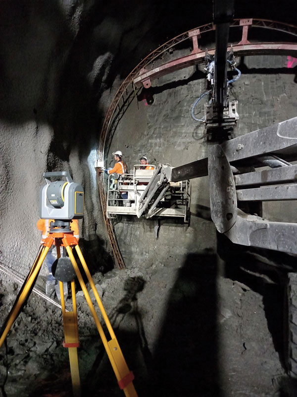
One of the largest container companies in the world needed a solution to manage its straddle carriers, which are specialized container handling vehicles at ports that can pick up large containers and move them to trucks, trains, or other container stacks. This is very challenging for container terminal operators because ports are highly complex operating environments that also provide other maritime services, such as storing and managing cargo, forwarding freight, and clearing customs. To handle containers safely and efficiently, modern terminals have buildings, equipment, and cranes in addition to straddle carriers. All this infrastructure creates a lot of multipath that stresses the capabilities of GNSS receivers.
To develop and install this new system for straddle carrier vehicles, the container company turned to JAVAD GNSS and to ALLSAT GmbH, a German engineering, geodetic and electronic company founded in 1991 that has been JAVAD’s German distribution partner since 1995. To address the challenge, in 2022, ALLSAT GmbH applied a new digital twin concept to supply and support the commissioning of several hundred JAVAD GNSS rover solutions at three international seaports. This required obtaining real-time and highly accurate positional data for moving straddle carriers and uploading it to a terminal information system for control and documentation.
ALLSAT deployed a geodetic conceptual design that integrates JAVAD GNSS Delta-3S receivers and RingAnt G5T and GrAnt-G5T antennas to deliver precise surveying of two GNSS reference stations per port, then commissioned the system on all the straddle carrier vehicles from a single source. It also developed a solution employing two redundantly operating reference stations that broadcast RTK correction data for all GNSS (GPS, Galileo, GLONASS, and BeiDou) on different IP addresses/radio frequencies. All the JAVAD RTK rovers can receive and process data from both correction sources in parallel thanks to their 874 channels and parallel processors. This offers two advantages. First, it provides a comprehensive fallback in the unlikely event that one reference station fails. Second, it greatly improves the reliability, speed and accuracy of the rovers, which operate in an environment rife with signal shadowing and multipath influences.
Working closely with its client and JAVAD GNSS, ALLSAT was able to implement this project, from initial idea to verification and commissioning, in only a few weeks. The combination of redundant, multi-constellation reference stations and JAVAD GNSS multi-base RTK yielded a solution that is highly reliable and available, providing for continuous operation despite the challenging environmental conditions. Additionally, JAVAD GNSS provides firmware updates for the life of the devices, which will enable the customer to rely on this base rover solution for the next 10 years.
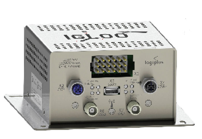
Tracking trains
M3 Systems
(Image: Logiplus)
M3 Systems, a French-Belgian geolocation company founded in 1999, has long supported the R&D activities of European space and civil aviation agencies. It also markets products that it developed through its R&D activities. In recent years, M3 Systems expanded its activities into the automotive and rail sectors. To develop a new device for trains, it partnered with two Belgian companies: Logiplus, which makes onboard electronic systems for trains, and ALSTOM Belgium, a division of ALSTOM group, which builds trains and equipment for train tracks. “The objective during the product design was the development of a hybrid sensor that uses both a GNSS sensor to provide absolute positioning, and an inertial measurement unit (IMU) to compensate for environmental obstructions such as trees and urban canyons by calculating the train’s position based on its last GNSS-based absolute position,” explained Jérémy Skelton, project lead at M3 Systems.
IMUs have long been coupled with GNSS because each technology compensates for the other one’s limitations: IMUs suffer from drift and GNSS receivers from signal loss in certain environments. In theory, surveying the tracks and using odometry to monitor a train’s linear position on them would suffice to locate it. In practice, however, wheel encoders “are prone to errors because the wheels are subjected to a lot of sliding and skidding,” Skelton said.“So, we need completely independent sensors.”
This requirement led ALSTOM to propose the development of the IGLOO (an acronym for IMU & GNSS vehicle odometry) input device, which integrates all the different sensors. Logiplus designed and manufactured the hardware, while M3 Systems wrote the algorithm.
The project, which was partially funded thanks to a grant from the European Regional Development Fund and supported by the Région Wallonne of Belgium, was divided into three components:
The software to couple the IMU and the GNSS to compute the train’s velocity.
The auto-calibration solution, which eliminates the need for automatic calibration when starting the sensor.
A hardware platform that incorporates a low cost IMU.
The consortium defines three kinds of zones in which a train will operate, depending on the trustworthiness in each zone of the GNSS signals. “For example, an environment with a clear view of the sky and no nearby obstacles is trustworthy,” Skelton said, “while a forest, an urban canyon, or the entry into a tunnel are not. Without GNSS support, eventually the IMU will also become unreliable.”
At very low speeds, errors must be very low, but at higher speeds a greater speed error is allowed. Operators can extract different levels of data from a GNSS receiver. To achieve a tight GNSS-INS coupling, they can use the Doppler delays and hybridize them with the IMU or use the tracking loop and set the range and Doppler. For a loose coupling, they can directly use the GNSS receiver’s positioning, velocity, and timing data. All couplings are performed by using Bayesian filters, for example the Kalman filter. “Loose coupling will give you less accuracy, reliability, and integrity, but it will also be less CPU-intensive,” Skelton said.
For data acquisition on a train, M3 Systems generated a printed circuit board (PCB) with a u-blox GNSS receiver, a Septentrio Asterix GNSS receiver, nine IMUs (which enables them to choose the best one for the use case), a reference trajectory unit that provides ground truth, and a computer that takes the data from the GNSS receivers and the IMUs. “Everything was integrated for measurement purposes on a rack on a train that runs here in Belgium,” Skelton said, “and all the data was retrieved automatically via a 4G internet connection. We have collected a few thousand kilometers traveled, a few hours of tunnels, and both trustworthy and untrustworthy GNSS signals.”
M3 Systems’ partner Logiplus designed the product to support the hybridization software and interface with the European vital computer (EVC), which monitors and continuously calculates the train’s maximum speed and braking curve. “It is critical for the EVC to have perfect knowledge of the train’s speed, which is the main reason we designed this new device,” Skelton said. “What is specific in that hardware is the computing power, the two systems (GNSS and inertial), and the data fusion algorithm, which allows the hardware to evolve. For example, we can switch to a different IMU.”
The IGLOO system complies with the specified safety requirements, contributing to a more reliable knowledge of the train speed, which reduces the risk of accidents and fatalities, improves traffic flow, and improves the efficiency and safety of the train operations, Skelton pointed out.
Surveying a railroad
Eos Positioning Systems
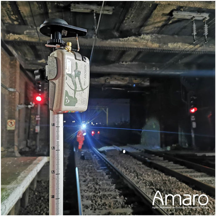
A rail tunnel at Leigh-on-Sea in East of England. Arcadis used Eos Arrow 100 GNSS receivers alongside Esri’s ArcGIS Survey123 to collect rail assets with submeter accuracy in real time. (Image: Amaro)
Network Rail, which owns and manages the railway infrastructure in England, Scotland and Wales, needed an as-is survey of up to 50,000 electrical assets along 400 miles of rails in the eastern region of the country. It turned to Arcadis, a design and consultancy firm that specializes in sustainable design and engineering services. The project required delivering accurate building information modeling (BIM) plans of the rail line to support operations and maintenance of the electrified infrastructure, while ensuring a safe working environment for the surveying teams. Using Arrow 100 GNSS receivers from Canadian manufacturer Eos Positioning Systems and Esri’s ArcGIS Survey123 and ArcGIS Hub software, Arcadis was able to efficiently capture the data with sub-meter accuracy and share it with Network Rail in real-time.
Arcadis decided to conduct a digital field survey to collect the data and to use GIS to manage it, said Gideon Simons, Associate Director of GIS and Geospatial Consultant at Arcadis. “We provided the survey teams iPads, the Esri application, and the GNSS receivers.” For corrections, it used the Ordnance Survey’s OS Net. “We found through a few assessments and testing that the Eos Arrow’s precision was good enough to meet the project’s requirements.”
The region surveyed is mostly rural but the rail line traverses some very urbanized areas. “One of the first challenges was surveying under cover in stations and in quite a few tunnels. So, we developed methodologies using georeferenced plans and imagery and taking temporary datums using GNSS outside the tunnels, to measure distance and offsets to the assets in the tunnels with measuring wheels that allowed for post-survey processing and the location accuracy required,” said Simons.
Photography was also a key to the success of the project. “In just one depot, we surveyed thousands of assets with many inside train sheds,” said Simons. “We use 360-degree cameras and train view cameras, so that we really understand where assets should be placed.”
The next stage for Network Rail is to maintain that equipment — whether it’s replacing it, bringing it up to code, or potentially installing new assets, Simons pointed out. “In the UK, we use a variety of measurements — imperial and metric. So, it’s been very helpful for the client to have just one source of truth reference that supports their work yet that can still link with other systems and ease communication with wider teams.”
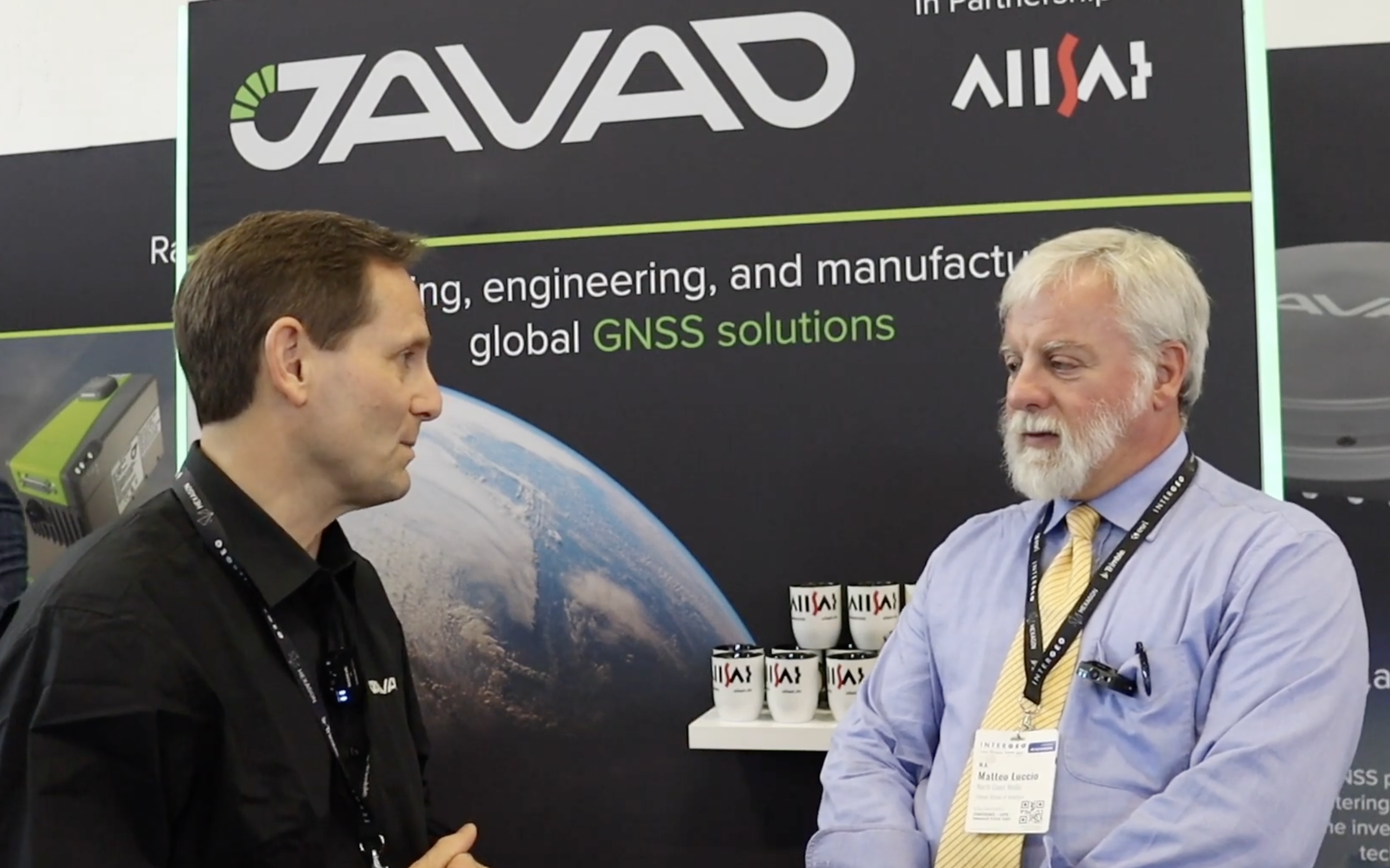
Matteo Luccio, editor-in-chief of GPS World, met with Andrew Scott, head of marketing and sales, JAVAD GNSS, to discuss INTERGEO 2023 and what to expect next from the company. Watch this exclusive interview and more from INTERGEO 2023.
On the first day of INTERGEO 2023, attendees flooded the exhibit hall. (All photos taken by GPS World staff).
The 29th INTERGEO conference and trade show on geospatial technology and data was held from October 10 to 12 in the German capital Berlin. This year’s event took place under the famous radio tower and in the brand new Hub27 conference center, part of the 42-acre Messe Berlin exhibit and conference center. The annual event takes place each year in a different German city.
Over the three days, 560 vendors from more than 40 nations exhibited their products, while people from across the globe attended presentations and vendor exhibits on geodesy, geoinformation and land management. Topics covered included Earth observation and environmental monitoring, maritime solutions, unmanned systems, building information modeling (BIM), GIS and artificial intelligence, metaverse and cloud applications, smart cities, digital twins, COPERNICUS and Galileo satellite services, 4D geodata, 3D cadaster, and smart mapping applications. The focus was on how these technologies and data are used to address issues of housing, mobility, sustainability, climate change and internal security, monitoring for disaster prevention and protection, and the creation of more equitable living conditions.
In conjunction with the conference, the German Cartography Congress 2023 also convened, with lectures on such topics as atlases, map collections, map design, and artificial intelligence. In her keynote address, Professor Monika Sester discussed how machine learning methods help with generalization and Professor Sebastian Meier gave a provocative lecture titled “Critical Cartography in Times of Hallucinating Machines.”
Attendees at a presentation from the exhibit hall stage.
Day 1, Tuesday, October 10
On the first day of INTERGEO 2023, keynote speakers included Jack Dangermond, founder and CEO of ESRI, professor Paul Becker, president of the Federal Agency for Cartography and Geodesy, Scott Crozier from Trimble and professor Rudolf Staiger, president of the organiser DVW e.V. The main theme was the centrality of geospatial science and technology to sustainability because the basis of socially, ecologically and economically sustainable decisions lies in the understanding of the Earth system. This is increasingly achieve using geoinformation gathered through Earth observation and many other sensors.
GPS World conducted short interviews with Gustavo Lopez, market access manager atSeptentrio and Deyn Deng, overseas sales manager at Unicore.
Some surveying supplies that have been used for centuries are still in use today.
Day 2, Wednesday, October 11
On the second day of INTERGEO 2023, the focus of the keynote presentations, like that of many of the products in the exhibit hall, was “smart cities” and building information modeling (BIM), including a panel discussion on the importance of BIM in Germany. Related themes discussed in the presentations, on the exhibit hall stages, and at vendors’ booths included connected urban twins, sensor data, real-time applications, urban twins as drivers of innovation for local governments, maritime solutions, Earth observation, and unmanned systems.
An autonomous bathymetric vessel from Teledyne Marine.
At a press conference on navigating sustainability through geospatial insights the participants were Rudolf Staiger, president of DVW, Boris Skopljak, Vice President survey & mapping strategy and product marketing at Trimble, Thomas Harring, president Geosystems at Hexagon, Gerd Buziek, Business Relations Executive at Esri Deutschland and Godela Roßner, head of Earth observation at Deutsches Zentrum für Luft- und Raumfahrt (DLR).
This UAV from CHCNAV can take off and land like a helicopter and fly like a plane.
GPS World conducted short interviews with Andrew Scott, Head of Marketing & Sales at JAVAD GNSS; Jamie Birch, product manager at OxTS; Mandy Clayton, Southeast Regional sales mganager at GeoMax (part of Hexagon); Florian Ollier, head of marketing & communications at SBG Systems; Andrei Gorb, division product manager, Mapping Solutions at CHCNAV; Rachel Wong, Survey & Engineering Product Line, product manager at CHCNAV; Marcel Visser, CEO of NavCert; Ken MacLeod, product line manager and Bruce Shields systems group director at Tallysman; and Morgane Selve, head of marketing at Yellowscan.
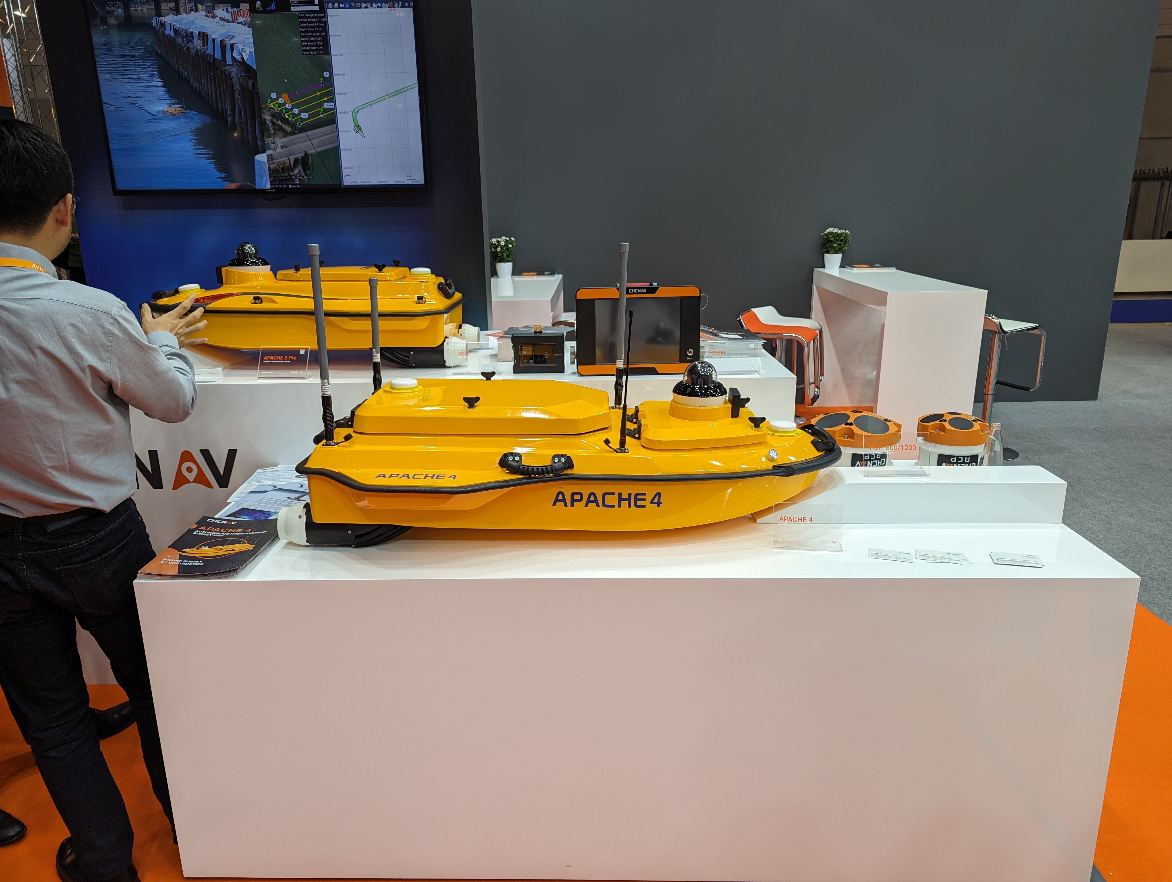
CHCNAV’s Apache 4 autonomous bathymetric vessel.
Visser told GPS World that his company had obtained from the German federal government sole responsibility to certify UAVs in Germany for commercial operations, including flights beyond visual line of sight (BVLOS).
JAVAD GNSS’ Triump-1M Plus receiver has 874 channels for acquiring all available GNSS satellites and patented mobile antenna technology for robust UHF and cellular communications. (Image: JAVAD)
As most readers of this magazine know, GPS, like the other three GNSS, consists of three segments: the space segment — i.e., the satellites; the control segment — i.e., the monitoring and control stations on the ground around the world; and the user segment — i.e., the receivers. The first two are developed, operated and maintained by the U.S. Space Force, while the third one, for civilians, is totally in the hands of the private sector.
Most of the progress in receivers is evolutionary, with rare dramatic changes. To provide a snapshot of the current state of GNSS receivers, I asked several manufacturers three questions. What follows are short, etre dited excerpts of their answers that showcase the applications of GNSS receivers in a wide range of industries.
What is one of the most recent end-user applications for your receivers? What challenges does it pose and how do your receivers address them?
Sarah Alban (SA): Eos Positioning Systems is lucky to have innovative customers who span a variety of industries. In just these past few weeks, we’ve connected to customers who are using Arrow Series GNSS receivers to meet myriad business needs. Here are just a few examples: On the Caribbean island of Martinique, Odyssi uses an Arrow 100+ with RTK to get accurate water utility locations in a challenging environment. In Texas, midstream pipeline operator Kinetik and its GIS Manager Papillon Romero equip their field workers with an Arrow Gold to update the locations of previously unreliable legacy as-builts. In the Galápagos Islands, a researcher has been using the Arrow Gold+ and Galileo High Accuracy Service (HAS) to georeference drone imagery. In Colorado, GIS specialist Jim Casey uses an Arrow Gold to bring to life a Japanese internment camp in augmented reality.
Simon Baksh (SB): One of our customers is a leading construction contractor who uses our DELTA GNSS receiver for monitoring during deep crack grouting deformation to ensure that the natural state of the ground remains undisturbed during remedial work.
Stephen Ching (SC): One of the most exciting projects happening within Hexagon’s Autonomy & Positioning division is the automated road train platooning application within the mining industry. Transporting raw materials, iron ore in this case, has posed a huge challenge in terms of drivers’ safety, labor shortages and rising fuel costs. Our division is currently developing an autonomous hauling system that solves this challenge by integrating drive-by-wire, perception, positioning and path planning technologies. Our positioning system utilizes a PwrPak7D-E2 plus TerraStar-C PRO solution from Hexagon | NovAtel, which incorporates GNSS+INS technology and real-time kinematic (RTK) From the Sky technology.
Mobile mapping systems such as the Trimble MX50 allow survey companies to safely and accurately gather point cloud and immersive imagery of roads without the need to put a surveyor in the field. (Image: Trimble)
Karl Bradshaw (KB): Traditional survey methods or tripod-based scanning on highways can be time-consuming and dangerous. Survey companies do not want to put surveyors in danger of traffic while traversing along a road. Mobile mapping allows them to safely, accurately and productively gather detailed point cloud and immersive imagery of highways without needing to put a surveyor in the field.
Oreste Concepito (OC): At u-blox, we have seen an increasing demand for GNSS receivers to be used for advanced driver-assistance systems (ADAS) applications and for mobile robotics (such as robotic lawnmowers). GNSS technology is adopted when an accurate, trustworthy position with high availability is required. In the autonomous operations domain, customers are constantly pushing u-blox to improve dependability while maintaining or ideally improving position accuracy, even in challenging environments.
François Freulon (FF): One of our most recent end-user applications is related to resilient timing for mission-critical infrastructure, including finance, data centers, energy and telecommunications. The relevant Septentrio product is the mosaic-T. The recent addition of the AtomiChron timing service further enhances its timing precision, GNSS resilience and anti-spoofing by offering navigation message authentication (NMA) on all for GNSS constellations. The first customer integrating this technology is Meinberg.
Miles Ware (MW): The Galileo High Accuracy Service (HAS) has created new interest in a traditional GNSS market, GIS and mapping, in which the availability of global 20 cm accuracy is turning many heads. While there are many technologies to improve accuracy for this market, few are appropriate. Often the work takes place in remote areas where cellular connectivity is not available for delivering corrections. They may also be in regions of the world where satellite-based augmentation systems (SBAS) are not available or able to meet performance expectations. Galileo HAS resolves both of these concerns. We now support it in our Phantom and Vega receivers.
In the past few years, we have seen the completion of two new GNSS constellations and a large increase in the options for corrections services. How has this impacted the design and/or features of your receivers?
SB: Our 874 channel TRIUMPH ASIC design has capacity for all constellations and signals to utilize current and future GNSS technologies. Additionally, our J-Star PPP Service using geostationary satellite broadcast for global delivery and cm level positioning extends operations to remote areas where networks are absent or where a base station setup and operation is not feasible.
SC: With BeiDou and Galileo in addition to GPS and GLONASS, there can be upward of 40 satellites in view — compared to 20 years ago when having 10 or 12 satellites in view was considered good availability. This gives much more choice as to which measurements contribute to a position solution, provided that the receiver can make measurements to all the satellites in view. Hexagon | NovAtel’s OEM7 was designed to support all GNSS constellations and frequencies, which required supporting many channels as well. The benefits of more satellites in the sky come under challenging conditions with many obstructions and strengthened positioning geometry in unobstructed conditions. In addition to more satellites, BeiDou and Galileo also introduced a new frequency at E6/B3, in addition to L1/L2/L5, which is particularly useful in global PPP solutions, such as RTK From the Sky and TerraStar C-PRO Correction Services.
KB: We have onboarded these constellations into our mobile mapping portfolio in the same way as all other Trimble GNSS portfolios, through rigorous, tried and tested methodologies.
FF: Septentrio receivers already support all GNSS constellations for high precision and resilient positioning. We have added Galileo E6 support and OSNMA, BeiDou phase III satellites (PRN>37) and other new signals (B3I, B2b) to our products through our latest firmware releases. We are also contributing to the large increase of corrections services by providing the backend core technology through our base station receivers or reference receivers. For example, the PolaRx5 reference receivers are used worldwide in many correction network infrastructures. With the support of all in view constellations and signals, Septentrio products are becoming part of critical infrastructure. Therefore, it is essential they have reliable continuous operation as well as security to protect them from potential jamming or spoofing attacks. Additionally, Septentrio has recently launched the Agnostic Corrections Partner Program to help customers find their way in the growing maze of correction offerings and to facilitate the integration of the right service into their system.
Geneq Inc. employee Alex Arsenault operating an SXblue Platinum receiver in Anjou, Montreal. (Image: Nikita Sapeguine / Geneq)
OC: Our customers are increasingly operating in a global market. To respond to that need, u-blox receivers support both the global and the regional constellations, such as Japan’s Quasi-Zenith Satellite System (QZSS) and India’s Indian Regional Navigation Satellite System (IRNSS, aka NavIC). The offer for correction services has also evolved to be able to serve the global market, moving toward uni-directional streams, possibly distributed via L-band. We support a complete portfolio of correction services, responding to all commercial and performance requirements, from the soon available, free-of-charge, lower accuracy correction services, up to the dm-level functional safety-certified correction services for autonomous driving.
MW: Since 2019, our core receiver technology has been intrinsically both multi-GNSS and multi-frequency by design. This allows our engineering team members to rapidly adapt to new and emerging solutions, and for Hemisphere to meet user and market demands. Hemisphere has also worked with our integrators to recognize the need to simplify the decision process around selecting receivers. While it is possible to configure our receivers to track specific constellations only, Phantom and Vega are being offered with multi-GNSS as standard. Similarly, clients can choose L1-only, or all-frequencies. This is why many integrators will quickly be able to take advantage of Galileo HAS.
RP: We have upgraded our SXblueGPS receivers with new GPS chips and with firmware updates to keep up with the new constellations available. Regarding the new correction services, the SXblueGPS have used and use by default the SBAS correction service and its associated networks throughout the planet to improve their precision. Where correction services via internet or SBAS do not exist, they use L-band correction services to have global coverage. In some cases, for topography base and mobile solutions, UHF links provide a customized correction service.
Are jamming and spoofing significant challenges in your key markets? If so, how do you address them?
SB: Yes, and AJ/AS expands on existing RAIM for assured position quality. Patented anti-jamming and anti-spoofing techniques identify and suppress GNSS interference, while maintaining navigation from good signals. Updated firmware for Navigation Message Authentication extends AJ/AS protection further.
SC: GNSS interference such as jamming and spoofing do present significant positioning challenges in many of our markets, especially defense, marine and autonomy applications in which safety and 24-7 operation are paramount. How often GNSS interference happens (and is detected) and how seriously it affects the application depends on the market. It is a threat that can be mitigated by well-designed user equipment. Hexagon | NovAtel has developed a comprehensive GNSS resiliency portfolio to assure that our users’ position is protected with our interference mitigation technology, starting from the GAJT antennas all the way down to the receiver level. NovAtel’s OEM7 receivers include our GNSS Resilience and Integrity Technology (GRIT) firmware options, which provides spoofing detection, interference detection, and mitigation with digital filters, as well as time-tagged digitized samples for advanced situational awareness.
KB: As it applies to mobile mapping with the Trimble MX50, jamming and spoofing are not significant challenges.
OC: A team of engineers is constantly improving our anti-jamming and anti-spoofing technology. U-blox customers are today more mindful of the risks associated with GNSS interference, both intentional and unintentional. GNSS is adopted in critical infrastructures and autonomous vehicles, where jamming and spoofing could lead to severe consequences. While no system can be safe in absolute terms, increasing the sources of information can greatly improve the resilience against jamming and spoofing attacks. Multi-constellation GNSS receivers, multi-band constellations, inertial sensors and accelerometers, can all be individually used as additional safety layers contributing to a more robust solution. Additional measurements are implemented at the positioning engine level, as part of our functional safety program. The availability of authenticated signals, being introduced by Galileo’s Open Service – Navigation Message Authentication (OS-NMA), will also contribute to increasing the GNSS robustness against interference.
Hemisphere GNSS’ GradeMetrix is a machine guidance solution for GNSS-based machine control and guidance applications. (Image: Hemisphere)
FF: Definitely, and we are seeing a large increase in demand for resilience in many applications and for assured positioning, navigation and timing (PNT). Providing trustworthy information is critical now for many markets, such as machine control, robotics, timing, infrastructure and assured PNT. Our multi-frequency multi-constellation GNSS technology not only maximizes accuracy and availability in areas where the sky is partially obstructed, but also provides extra resilience against jamming and spoofing. All our GNSS receivers are resilient to jamming and spoofing thanks to the built-in Advanced Interference Mitigation (AIM+) technology, which suppresses the widest variety of interferers, from simple continuous narrow-band signals to the most complex wideband and pulsed transmissions.
MW: Fortunately, jamming and spoofing are not common occurrences in most of our markets. However, their nature is such that they can appear at any time, in any place, without warning. This can cause otherwise routine plans for users to suddenly grind to a halt. Hemisphere’s Cygnus interference solution provides protection against up to 60 dB of jamming and is built into our current generation products by default. Having Cygnus available can make the difference between working normally and searching for alternate solutions. A welcome tool offered through Galileo satellites is OS-NMA signal verification, which provides excellent protection against spoofing attacks. Firmware updates provide our current product platforms access to OS-NMA spoofing protection. As our standard products are already activated for multi-constellation operation, it simplifies integration for our users.
RP: Interference is inevitable given the enormous number of signals from telephone and electrical networks, among others, as well as buildings, trees and, of course, the weather. To mitigate this, we use multi-frequency and multi-GNSS antennas that allow us to obtain the best reception in areas of interference. Additionally, we have state-of-the-art GPS chips that block and purify signals that generate distortion. On the other hand, there is interference by intentional GNSS falsifications or by radio amateurs who transmit radio signals for drones and other devices that cause GPS signal loss, which are mitigated by the latest technology algorithms of our SXblueGPS.
A roundup of recent products in the GNSS and inertial positioning industry from the August 2023 issue of GPS World magazine.
SURVEYING & MAPPING
Laser Scanner With several integration options
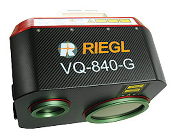
The VQ-840-G is a fully integrated compact airborne laser scanner designed for combined topographic and bathymetric airborne and UAV-based surveying. The system is offered with an optionally integrated and factory-calibrated inertial measurement unit/GNSS system and can be complemented with an optional camera or IR rangefinder. It also has an optional integrated inertial navigation system. The scanner carries out laser range measurements for high resolution surveying of underwater topography with a narrow, visible green laser beam, emitted from a pulsed laser source. The VQ-840-G has high spatial resolution due to a measurement rate of 200 kHz and high scanning speed of up to 100 scans/second. Riegl, riegl.com
Laser Scanning System A versatile reality capture solution suitable for surveying, construction and engineering users
The X9 is designed to enhance performance in more environments while leveraging Trimble’s X-Drive technology for automatic instrument calibration, survey-grade self-leveling and laser pointer for georeferencing. The X9 expands on Trimble’s X7, delivering longer range, higher accuracy, shorter scan times and sensitivity, improving scan results. Advanced processing and a high-performance laser increase the sensitivity of all scans, enabling the X9 to capture difficult dark or reflective surfaces. A new center unit design also improves signal transmission for better scan quality. The X9 provides accurate and dependable data, enabling confident decision making both in the field and in the office through in-field registration with Trimble Perspective and FieldLink software by minimizing the need for target deployment. The auto-calibration eliminates the need for annual calibration. In addition, the X9 includes survey-grade self-leveling with the industry’s widest compensation range for fast, easy setup. The X9 data can be delivered directly from the Perspective or FieldLink software to Trimble’s office software — including the Realworks 3D scanning software — business center office software, SketchUp and Tekla, or exported to industry-standard formats to produce application-specific deliverables. Trimble, trimble.com
Survey Cameras For photogrammetric applications and to complement lidar survey data
The C5 and C30 orthographic and oblique cameras are designed for aerial surveys. The systems provide high-quality imaging solutions for photogrammetric applications and to complement lidar survey data. The C5 camera is an efficient and lightweight system for aerial surveys, weighing 290 g for increased flight endurance. Its compact size of 75 mm x 63.5 mm x 102.5 mm allows easy integration into UAVs. The C30 camera’s weight is 600 g with a size of 110mm x 108 mm x 85 mm. The C30 is also designed for aerial surveying. The C5 and C30 cameras’ universal installation design makes them compatible with a wide range of fixed-wing and rotor UAV platforms. Both cameras are supported by the CHCNAV’s BB4 Mini and P330 Pro UAVs as well as the DJI’s M300 RTK. The C5 and C30 cameras give maximum flexibility for photogrammetric applications. They can be used independently on real-time kinematic-enabled UAVs to capture high-resolution imagery or installed directly on the CHCNAV’s lidar series to colorize point cloud data. This feature allows seamless imagery and lidar data integration for a more complete view of the surveyed area. CHC Navigation, chcnav.com
GNSS Palm RTK For surveying and mapping, GIS and more
The T20 is light, weighing 0.68 kg, and has low power consumption with 12 hours of battery life. It integrates functions such as a GNSS module, datalink module, 4G, 5.0 dual-mode Bluetooth, data memory system and more. Powered by the SinoGNSS K8 high precision module, the T20 has 1,590 channels and can track all running and planned constellations including GPS, BDS, GLONASS, Galileo, QZSS and satellite-based augmentation systems. Additionally, the anti-interference algorithm enables the T20 to maintain accurate positioning and perform well in complex environments, providing surveyors with high-quality measurements. The T20 is equipped with a third-generation inertial measurement unit from ComNav, which can be tilted and measured at an angle up to 60°. The T20 is also equipped with a U50 datalink module, which enables it to switch between base and rover. The T20 is compatible with mainstream real-time kinematic receivers on the market. ComNav Technology, comnavtech.com
Hybrid Imaging and Lidar Sensor Designed for airborne mapping
The CountryMapper is designed for large-area imaging and lidar mapping. Combining a large-format photogrammetric camera with a high-performance lidar unit into a single system, the CountryMapper collects foundational geospatial data simultaneously to support a wide variety of user applications. The CountryMapper combines imaging and lidar sensor modules into a highly efficient hybrid airborne system. The sensor features CMOS-based Leica MFC150 camera modules that leverage true mechanical forward-motion-compensation to deliver high image quality. The sensor’s new Hyperion3 lidar unit features 60° field of view, improving the performance and flexibility of the system compared to previous lidar modules, while reduced laser divergence provides greater planimetric accuracy and better foliage penetration. The CountryMapper fully integrates with Leica HxMap multi-sensor end-to-end processing workflow, enabling distributed processing of images and point clouds to optimize productivity for very large data sets. The CountryMapper supports applications such as orthophoto generation, terrain mapping, hydrography, forestry monitoring and infrastructure management. Users of previous-generation sensors can leverage their initial investment and upgrade their systems to the CountryMapper configuration. Leica Geosystems, leica-geosystems.com
MOBILE
GNSS Network Rover Complete with an integrated MEMS IMU
The Triumph-3NR (T3-NR) is a small, lightweight GNSS network rover with more than 25 hours of run time on a single charge. The T3-NR easily connects to real-time networks for corrections to get GNSS real-time kinematic with inertial measurement unit tilt compensation. The network rover has 874 channels and can track all constellations. It features an internal GNSS antenna, Wi-Fi, Bluetooth, and is USB compatible. The T3-NR is suitable for demanding industrial applications. JAVAD, javad.com
Antennas Suitable for lawn mowers and other mobile applications
The HX-CSX014A is a high gain, low profile and compact antenna with a new structure that simplifies integration into lawn mowers and minimizes the overall machine dimension. It features small size, high sensitivity and low power consumption. The HX-CSX231A, is a ready-to-use GNSS antenna with a highly reliable structure that makes it small and lightweight. It exhibits 4.5 dBi high gain performance with ultra-low signal loss. It also delivers wide beam width that covers wide frequencies with high marginal gain, a perfect option in complex environments. Additionally, the HX-CSX231A’s advanced LNA features improved signal filtering, out-of-band rejection, restrained unwanted electromagnetic interferences and a strong multi-path reduction capacity. Harxon, en.harxon.com
DEFENSE
PNT Device Enables dismounted maneuver operations even where GPS is compromised or denied
The TRX DAPS II provides assured positioning, navigation, and timing (PNT) to dismounted users by disseminating assured position and time to dependent devices in GPS-challenged environments. TRX DAPS II fuses inputs from M-code GPS, inertial sensors, and complementary PNT sources. It is a small, lightweight PNT device that supports both standalone operation and integration with the Nett Warrior ensemble. It also can distribute PNT information to a customized tactical watch. The TRX DAPS II solution employs a modular architecture and adheres to Army PNT interface standards, facilitating the addition of new PNT sensors as threats evolve. This device will be in production for the Army later this year. TRX Systems, trxsystems.com
TIMING
Image: Microchip Technology
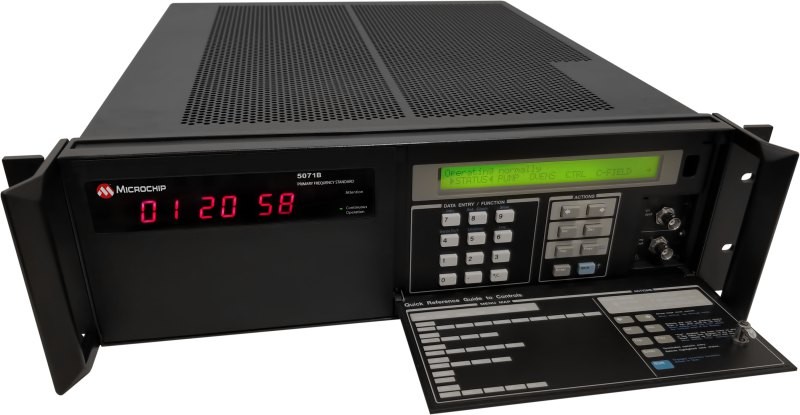
Atomic Clock Maintains system synchronization when GNSS signals are denied
The 5071B cesium atomic clock can perform autonomous time keeping for months in the event of GNSS denials. This device is the next-generation commercial cesium clock to the 5071A. The 5071B is available in a three-unit height, 19-in rackmount enclosure, providing a compact product to work in environments where it can be easily transported and secured versus a larger alternative designed specifically for laboratory environments. The 5071B has upgraded electronic components to address possible obsolescence or non-RoHS circuitry. The clock provides 100 ns holdover for more than two months, maintaining system synchronization when GNSS signals, such as GPS, are denied. As a cesium beam tube product with no deterministic long-term frequency drift, the 5071B provides absolute frequency accuracy of 5E-13 or 500 quadrillionths over all specified environmental conditions for the life of the product. For military applications requiring rapid deployments for system radars, 5E-13 stability eliminates the need for the acquisition of external synchronization sources prior to radiating. Microchip Technology, microchip.com
OEM
GNSS Positioning Modules
For multiple applications
automation of moving industrial machinery, and the ZED-F9P-15B provides customers in the mobile robotics market with an L1/L5 option in addition to the L1/L2 bands. These two modules are based on the u-blox F9 high-precision GNSS platform. The NEO-F9P and the ZED-F9P-15B GNSS modules feature concurrent reception of GPS, Galileo, and BeiDou; multi-band L1/L5 real-time kinematic; short convergence times; and reliable performance. The modules deliver centimeter-level accuracy in seconds and come in small, high-precision form factors.
Its small size, coupled with very low power consumption and ANN-MB1 antenna compatibility, makes the NEO-F9P suitable for a wide range of uses. Offering reliable and efficient positioning, the module supports open as well as standards-based correction services for enhanced performance, such as the u-blox PointPerfect GNSS augmentation service. u-blox, u-blox.com
Image: Septentrio
GNSS Receiver Module
Features built-in AIM+ technology for interference mitigation
The mosaic-X5 is a multi-band, multi-constellation GNSS receiver in a low power surface mount module with a wide array of interfaces. It is designed for mass market applications such as robotics and autonomous systems — capable of tracking all GNSS constellations, supporting current and future signals. The mosaic-X5 has an update rate of 100 Hz, is easy to integrate, and is optimized for automated assembly. The mosaic-x5 is suitable for autonomous vehicles, logistics and port operations, mining and construction, precision agriculture, rail, robotics, surveying and mapping, UAVs and more. Septentrio, spetentrio.com
Land surveying is an ancient practice, dating back at least 5,000 years to when Egyptian rulers used it to tax land plots. Over the centuries, it has been repeatedly transformed by new technologies — the compass (about 200 B.C), the theodolite (1550s), Gunter’s chain (1620), the sextant (1757), electronic distance measurement (1950s), and total stations (1970s). Then came GPS, followed by the other GNSS and corrections services.
Now comes sensor fusion, which aims to compensate for the limitations of GNSS — orbit and satellite clock errors, ionospheric and tropospheric delays, multipath, dilution of precision, urban canyons, jamming, extremely weak received signal, etc. — by integrating it with other sources of positioning data, including inertial measurement units (IMUs), lidar sensors and cameras. Even crowdsourced geolocation data collected with cell phones help expedite surveys by guiding surveyors to landmarks.
In the following article, representatives of five companies share their perspectives on recent advances in surveying and the remaining challenges.
Many More Satellites
City Rail Link is New Zealand’s first underground rail network and the largest transportation project ever undertaken there. In this photo, taken at Karangahape Station, the Mined Tunnel Team installs a lattice girder secondary support structure using a Trimble SX12. (Photo: Link Alliance)
Compared to just a few years ago, there are many more GNSS satellites, signals and options for correction services. Over the past decade, the average number of satellites in view has more than doubled to more than 40 today. Some parts of the world have more than 70 satellites in view, said Boris Skopljak, vice president, Surveying & Mapping Strategy and Product Marketing at Trimble Inc.
“The developments in GNSS field systems have always been geared toward simplifying workflows, improving accuracies and increasing productivity,” Skopljak said. “In the last few years, we’ve seen that on a massive scale. In some of our materials, we no longer even quote how many signals our GNSS receivers are tracking.”
The vast increase in the number of satellites has extended high-precision applications to the robotics and automotive markets. The challenge now is “position solution,” not just GNSS, said Simon Peng, director of the Overseas Department at ComNav Technology. The improvements in the satellite constellations, antenna technologies and algorithms also enable surveyors and other users to obtain results faster and to operate in environments previously impervious to GNSS, such as under heavy canopy and very close to buildings.
“Our customers can now operate in environments where there is no virtual reference station (VRS) infrastructure or real-time kinematic (RTK), by leveraging precise point positioning (PPP) solutions, such as the Trimble RTX corrections service,” Skopljak said.
“Additional satellite signals and constellations (like Beidou),” Skopljak said, “improved antenna technology and continuously evolving algorithms are contributing to improving the RTX accuracy while bringing the convergence times to almost instantaneous in normal conditions and making technology available in more regions.”
“When I first started surveying, if we had a 12-channel receiver, that was doing very well,” recalled Jesse Huff, head of Sales and Marketing, JAVAD GNSS. “Now, we’re tracking 36 birds in the sky at one time with an 874-channel receiver. That’s phenomenal.”
Huff described a patent-pending feature called real-time post-processed kinematic (RTPK). “It combines RTK, PPK and PP techniques, with multiple core processing engines and a single solution coming out of that. It is impressive standing underneath a giant oak tree and surveying that monument with GPS and knowing what your accuracies are. We’re not even chasing RMS values; we can report the actual positional uncertainties, which is amazing.”
Pole tilt compensation enables surveyors to precisely and easily localize points that are difficult or dangerous to access. (Photo: ComNav Technology Ltd.)
“With so many signals and the new ways of how we compute positions based on PPP technology, we can almost globally get to centimeter-level positioning within a couple of minutes from just one global correction link,” said Bernhard Richter, vice president of Geomatics at Leica Geosystems AG, part of Hexagon. “Under optimum conditions, you can have almost an instantaneous global accuracy of a couple of centimeters.” In mature areas, he added, a local RTK network infrastructure enables achieving centimeter accuracy within a couple of seconds.
Galileo, Richter pointed out, will be fully operational in 2023 with great signals, though he’s “a bit skeptical” about the system’s target date for its high-accuracy service. “So, we will basically get global constellation corrections that allow us also centimeter-level positioning.” BeiDou has been fully operational since 2020. “GLONASS is more unpredictable,” Richter said. “It looks like modernization is slowing down a bit, in particular the CDMA developments.” Additionally, he pointed out, it is possible that one or more governments may decide not to use those signals, for military or political reasons. “It’s not the manufacturers who decide which signals to take.”
“In open-sky conditions, additional satellites have added redundancy — which is always good for position integrity — but it’s only when obstacles start to appear on the horizon, blocking out parts of the sky, that all-in-view RTK really comes into its own,” said François Freulon, Head of Product Management at Septentrio. When they did not have a full view of the sky, he recalled, GNSS users used to have to carefully schedule their work to coincide with times of high satellite visibility. “Nowadays, by using multiple constellations and signals, RTK can reach the parts that receivers in the past could not tread. More signals and constellations have also helped in easing the collection workflow for surveyors, making the capture of data in difficult conditions much quicker and more efficient.” New correction services are further simplifying the workflow “thanks to new positioning techniques, pricing business models and simplified network density.” However, corrections companies still face challenges in ensuring that centimeter accuracy can be uniformly achievable at a global scale.
Sensor Fusion
The ongoing evolution in computing power and communication technology “leads to many more sensor combinations,” Skopljak said. “We are not talking about GNSS alone anymore. We are talking about integrating a GNSS antenna, a receiver, an IMU, power and communications into a single compact housing.” The integration of inertial sensors makes it possible to localize the instrument rod tip when the pole instrument is tilted. “That allows our customers to measure more safely in dangerous environments.”
“We are reaching a maturity stage of what we can do only with GNSS,” said Richter. “It’s all about sensor fusion. The problem when signals are obstructed, that’s not solved, even though we can do positioning from Wi-Fi hotspots or from local pseudolites.” So, fusing data from cameras, lidar, GNSS and IMUs in better ways is the way to go and presents “a huge open research ground.”
For Richter, the challenge is not just positioning, the orientation of objects is almost as important as that, especially for such tasks as machine control. “It’s also about what you do with the data that you collect. Hexagon’s vision is of an autonomous future where we put data to work in connected ecosystems to boost efficiency.” However, he pointed out, this requires large amounts of data, such as those from aerial photogrammetry, lidar and mobile mapping systems used to create city models and digital twins of buildings. “If you really want a car to drive autonomously through a city with all the things that could happen, you must rely on a perfect replication of the real world,” he said. Other examples he cited are more efficient evacuation plans and flooding simulations. “GNSS will never be enough, but it will always be a very good enabler because it works.”
Classes of Receivers
JAVAD GNSS designed its TRIUMPH-LS Plus receiver to work under heavy tree canopy. (Photo: JAVAD GNSS)
Two decades ago, we would often group GNSS receivers by accuracy into three buckets: consumer grade, resource or mapping grade, and survey grade. As accuracy has increased for all GNSS receivers, the boundaries between those categories — especially between mapping and surveying — have blurred. “The performance of GNSS has increased so much that we are not using the traditional accuracy-based differentiation between surveying and GIS,” said Skopljak. “For mapping professionals, 10 years ago it was all about points, lines and polygons; now it is all about locating assets and adding the most accurate positions as attributes to those assets. For our survey and engineering customers, what matters is still geometry and working with the models to serve the connected construction in the field.” As for the pure GNSS technology stack, “we are seeing fewer differences between mapping and surveying receivers, but we are focusing on serving the customer in terms of product-as-a-service or as a productivity tool.”
Huff made two points. First, that “survey grade” does not necessarily equal RTK. “Some education needs to happen so that people understand RTK as a technique, not an accuracy. You can get poor accuracy and poor fixes with RTK, even when you’re using good techniques. So, when I say ‘survey grade’ I’m still talking about the full frequency receivers, using all available signals.” Second, that consumer-grade receivers, such as the chipsets in our phones and computers, do not require the same robustness as professional ones. “While they may be achieving the same precision, surveyors must be able to defend their position in a court of law.”
Huff cited the “phenomenal” success of the simultaneous localization and mapping (SLAM) movement with all kinds of positioning challenges. “From a survey perspective,” he said, “we’re dealing with a much more feature-rich dataset than we were even just 10 years ago, with everybody having some type of GPS device on their phones. There are location tags on everything. That creates evidence for the surveyor to be able to go out and recreate things, reduce trips to the field, reduce rework times — all those things that make a surveyor’s life much easier.”
Surveyors now can fly aerial surveys of hundreds of acres in less than half an hour using drones with RTK, Huff said, instead of having to wait for the flying season with traditional airborne photos. If needed, they can pick a few ground-control points for ground truthing. “We’re able to do that with photogrammetry techniques, but using GNSS technology to position drones, whether it’s real time or post-processing, has definitely made surveying jobs easier.”
Correction Services
The adoption of GNSS in construction is growing and receiver manufacturers are making it easier to use their equipment in the field. (Photo: Leica Geosystems)
Correction services — such as satellite-based augmentation systems (SBAS), the ground-based Wide Area Augmentation System (WAAS) and the European Geostationary Navigation Overlay Service (EGNOS) — make a big difference along with PPP and similar techniques when base stations are not available. “We have the whole CORS network here in the United States,” Huff pointed out. “We also have services available from the National Geodetic Survey.”
Those who don’t want to have to fully engage in post-processing can upload their data to the Online Positioning User Service (OPUS), AUSPOS (a free online GPS data-processing facility provided by Geoscience Australia) or other corrections services that will post-process positioning data. “It has made it more accessible for all the surveyors all the way around, especially as the technology has improved and the cost barrier to entry into a survey-grade GPS receiver has come down significantly as well,” Huff said.
Growing Adoption of GNSS
The greater number of satellites in orbit significantly reduces convergence time and increases the accuracy of the solution, which makes the technology much more user-friendly for professionals and nonprofessionals alike.
For surveyors and mapping professionals, the increasing levels of GNSS performance means that “GNSS continues to be the dominant equipment and they can operate in challenging GNSS environments while still meeting the accuracy and precision requirements,” Skopljak said. GNSS usage is also growing in such industries as agriculture, construction, transportation and logistics. “Now, when farmers are on a combine, they don’t have to wait for an RTX or PPP solution to converge for 20 minutes. The solutions just work, and they can perform their task.”
Skopljak also pointed to “more flexible business models, such as pay-as-you-go or equipping seasonal workers or fleets of spatially enabled consumers to use GNSS,” that reduce the required upfront investment. “Surveyors now can go for longer and be productive in more areas where they could not use GNSS technology before. The non-surveying professionals — such as in natural resources, farming or construction — now can just turn on the machine and things work for them. They don’t have to worry about coordinate transformations and things like that.”
“Twenty years ago, when RTK and networks kicked in and then became popular, we were discussing whether it was the end of the automated total station,” Richter recalled. “Yet, the number of automated total stations has grown ever since.” To him, this is proof that GNSS alone will never solve all surveying problems. GNSS’ weak signal will always require surveyors to supplement it with other sensors, such as reflectorless total stations. “These instruments always need to work in harmony,” Richter said.
Success on both construction sites and in machine control require a very good robotic total station and a very good GNSS receiver, Richter said. “The simple problem of leveling a pole is actually solved, and we are using the technology that we developed for tilt-compensating GNSS receivers. We’re leveraging this now into the world of the total station.” This has solved one of the fundamental problems surveyors have long had, because they no longer need to level up and can measure tilted poles with a total station and with a GNSS receiver. “We have also made it very seamless for surveyors to switch between using GNSS receivers and total stations,” Richter said.
In recent years, the architecture, engineering and construction (AEC) industry has benefited greatly from growing GNSS accuracy, smaller laser scanners, UAVs, and more efficient management, collaboration and visualization software. We asked five companies operating in this space to address three questions:
What are the key challenges of surveying for the AEC industry today, compared with traditional boundary surveying and other types of surveying?
Which of your products are particularly relevant for this kind of surveying?
What was a recent AEC surveying success story?
In the following articles, five companies briefly describe their experience with the AEC industry:
Shawn Billings, RPLS, reinvests some of his profits in surveying gear, like this JAVAD GNSS unit. (Photo: Rebecca Billings)
By Shawn Billings RPLS, Proprietor, Pendulum Surveying and Dealer
The AEC industry relies on surveyors to be a bridge between the existing landscape and the design landscape. Surveyors have been providing virtual reality for centuries, albeit in a mostly analog way, until very recently.
Imagine that a school board needs a new school. It describes the need to an architectural or civil engineering company, which develops a conceptualized plan. Next, it is time to figure out how to adapt this rough concept to the real world. Will the school fit within the boundaries of its district’s property? How will it access public rights-of-way? Can the current roads accommodate the traffic it will bring? How will the school access utilities? How will the building impact existing stormwater drainage? How do various data collected by others (such as geotechnical and wetlands delineation) fit into the site plan?
The data collected by the surveyor inform the designer, usually in the form of a map — historically on paper, but now in digital form. Most designers want the key features extracted rather than a dense point cloud, so it is important for surveyors to be able to understand what those key features are.
AEC surveying differs from boundary surveying in several ways. First, it usually requires consideration of a 3D world, not only two dimensions. Secondly, it will usually involve many thousands of points, not a few tens of points as is usually the case in boundary surveying. Third, AEC surveying will typically involve many more stakeholders. Fourth, the liability in AEC surveying will usually (but not always) be greater because of the significant costs involved.
AEC surveying can be challenging because the timeframes are typically tight, with numerous professionals involved. Surveyors will often have to wait on others one day, only to be rushed the next day once the ball moves into their court. However, the tools available to us today allow us to collect data much more quickly than we ever could before.
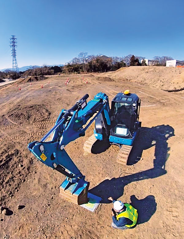
Today, I can carry almost everything I need to survey in a compact car—my Javad GNSS real-time kinematic (RTK) system, my robotic total station, my handheld electronic distance measuring device, my laptop computer, my smartphone (which provides internet access), my digital camera, my lidar and my photogrammetric drone, as well as the accessories needed for each device. All these devices have become more portable, more powerful, and less expensive. The gains in efficiency have reduced fieldwork by more than half over the past couple of decades, requiring fewer people and generally providing much better quality data.
Today, it is rare for a surveyor to provide paper deliverables to designers. Almost all prefer digital files, usually vector data in DWG or DGN format along with surfaces in XML format.
Recently, I have worked on several small commercial building projects. The requirements were the same for each. The initial survey includes (among other things):
a title boundary survey
the location of existing utilities and structures
contours at one-foot intervals
the delineation of the floodplain, if present on the site
the location of streets and other public access.
Once the initial survey is complete, I often set control for machine control, which heavy machinery uses to perform grading without requiring stakes. Once grading is complete, I often stake out building locations and sometimes paving.
Challenges have included working with city planners who do not always have the same sense of urgency as the project developers and designers.
Perhaps the greatest lesson I have learned is the importance of being efficient without being in a hurry, which breeds mistakes, such as missing important details or breaching a safety protocol and causing a serious injury.
I also have learned that while technology can increase profits, it is important to reinvest some of them into improving my work product. This way, I enjoy a better return on my investment, but I also enjoy a better deliverable for my clients.