Jamming Signals Criminal Activity in Intermodal Ports
By Logan Scott
More than 25 million containers pass through U.S. intermodal ports every year, with port operations valued at more than $1 billion per day. Measured in 20-foot equivalent units (TEU), the World Bank reports that worldwide, more than 600 million TEU passed through intermodal ports in 2012: 155 million through Chinese ports, 95 million through the EU ports and 43 million through U.S. ports.
The Port of Long Beach alone handled 6,820,806 TEU in 2014. GPS is a central component of automated port operations, but because GPS is widely used in asset tracking and monitoring, it has also become a target for denial-of-service attacks. If we look to the history of computer security, the initial attacks were mostly nuisances, but as criminals figured out how to monetize attacks, the attacks became more damaging, more sophisticated and more profitable.
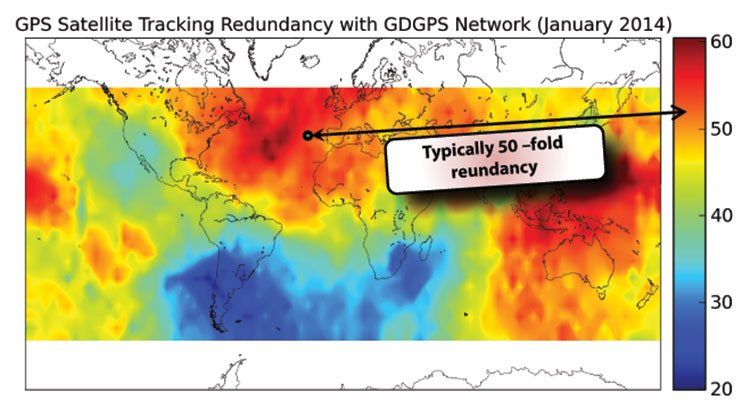
In January, the U.S. Coast Guard held a public meeting on Maritime Cybersecurity Standards at Department of Transportation headquarters in Washington, D.C. Brett Rouzer, chief of Maritime Critical Infrastructure and Key Resources Protection, Coast Guard Cyber Command, described how a major East Coast intermodal shipping facility was degraded by a GPS disruption for more than seven hours. Two ship-to-shore cranes ceased operation due to loss of position, and two others were degraded. Ports are highly automated; ship-to-shore cranes are just one of the container-handling systems critically reliant on GPS. Fully automated ports providing services for unmanned container ships, trucks and trains lie within the realm of feasibility in the near future.
Rouzer did not specify the motivates for the disruption, how the attack was mounted, or if the shipping facility was even the intended target of the attack (I suspect it was not). Jamming is not a highly selective process, and it can affect numerous unintended targets.
In June 2014, I reported to the PNT Advisory Board on how every third or fourth truck on Highway 30B near Portland (Oregon) International Airport was radiating at or near the GPS L1 frequency. This highway leads to several nearby Port of Portland intermodal terminals west of the airport. The Federal Bureau of Investigation recently reported that “In 46 reported incidents, the thieves placed one or more GPS jammers in cargo containers with stolen automobiles” (italics mine). High-end automobiles command premium prices in foreign markets and are stolen and shipped out of the country within hours, usually via intermodal container. Active jammers can affect not only the automobile’s GPS tracker, but also trackers on other containers, ship’s navigation systems, straddle carriers and ship-to-shore cranes. Again, jamming is not selective.
Of particular note as cited above, criminals are beginning to use multiple jammers. Car theft rings are not unique in this. According to the Pharmaceutical Cargo Security Coalition in July 2014, “a tractor and trailer hauling $2 million worth of pharmaceutical products was stolen from a truck stop in Cartersville, Georgia, with the thieves deploying two separate GSM jammers.” The criminal’s motivation is that tracking devices can be hard to find and disable; just because you found one doesn’t mean that there isn’t another. The use of multiple jammers in criminal enterprise is indicative of a threat escalation where bad actors are seeking higher effect. This could lead to higher jamming powers and so on; and also more collateral damage.
Response
What is a correct and measured response to threats against navigation and timing? The key is to be on the lookout for emerging threats and to have a flexible response. Early detection usually yields a more effective and lower cost response; witness Ebola and ISIS. Following a public health model would seem to offer better prospects for protecting access to PNT. To this end, I would argue that situational awareness is the first important step.
One of the most striking comments that Sarah Mahmood (DHS) made at last June’s PNT Advisory Board meeting was about how backup systems are often not activated or used because the GPS receiver fails to recognize that there is a problem. As we move towards resilient PNT architectures, one of the most critical needs is to be able to distinguish good signals from bad signals and act accordingly.
Most GNSS receivers already have fairly advanced jamming detection capabilities by virtue of having an automatic gain control. Sudden changes in precorrelation input power levels are not normal and can indicate jamming or RF spoofing. Many GNSS receivers, particularly those that go into embedded mobile applications, also have sophisticated spectrum- and temporal-analysis capabilities, used mainly for diagnostic purposes in looking for interference sources from other components of the device. This same capability can be used in detecting and fingerprinting jammers. We already have the smoke alarms; we must amplify their use and visibility to the wider community of GNSS users and beyond.
Detection
One notable aspect of the port incident was the duration: more than seven hours. Rapidly finding and disabling the jammer was clearly a problem in this case. The old adage is that to find a stationary source (jammer) you need to be moving, and to find a moving source, you need to be stationary. Trucks and trains entering or leaving a port all pass through gates that can act as a simple chokepoint for detecting and finding active jammers. Properly hardened ship-to-shore cranes and straddle carriers can also act as a chokepoint. Straddle carriers used in moving containers around the yard and between modes could be very good at finding stationary jammers.
There are numerous relatively low-cost approaches for finding jammers in support of enforcement actions. One additional point: law enforcement officials need to be better educated as to why they should be interested in jammers; jammers point towards a crime much like smoke points to a fire.
Given the economic criticality of port operations and the concentration of assets (and asset trackers), we may see increased incidence of GPS disruptions. The situation is not critical yet, but it does bear watching. If jamming events increase or it takes too long to find and disable jammers, improved operational resilience will be needed.
Inertial measurement units are already used in many critical applications, but they don’t offer long-duration capability. They drift. Using adaptive arrays in critical equipments is another possibility, but they are not a panacea. Adaptive arrays are physically large, and standard null-steering approaches are not compatible with RTK processing. Precise positioning systems based on GNSS require specialized antenna-receiver designs to achieve a high level of jam resistance.
While I strongly believe eLoran is an urgently needed augmentation for resilient wide area navigation, it is not capable of the centimeter-level precision required for machine control, for example ship-to-shore cranes and straddle carriers.
High-precision local-area positioning systems based on optical systems, RFID and/or Locata-style systems may be the best approach for creating a defense in depth.
And then there is the cybersecurity question, which I will leave for another day.
Note: A video of the Coast Guard meeting is on YouTube. Rouzer’s talk starts at 36:30, with the port jamming incident mentioned at 48:51.
Logan Scott has 35 years of military and civil GPS systems engineering experience. He is a consultant specializing in radio frequency signal processing and waveform design. At Texas Instruments, he pioneered approaches for building high-performance, jamming-resistant digital receivers. He is a co-founder of Lonestar Aerospace, an advanced decision analytics company in Texas. Logan is a Fellow of the Institute of Navigation and holds 37 U.S. patents.
When subjected to very strong interference, a GNSS receiver can be totally blinded and stop working. This is often the scope of intentional jammers. However, in a number of cases the presence of interference is severe enough to significantly decrease receiver performance, but not so much as to make the receiver lose its lock on the satellite signals or blind the acquisition of the satellite signals.
Such intermediate power values turn out to be the most dangerous cases, because sometimes they cannot be detected, but lead to a worsening of the positioning performance. The accuracy of the position solution depends on, among others, the quality of the pseudorange measurements and/or the phase measurements. Thus, when radio-frequency interference (RFI) degrades the pseudorange and phase measurements or induces cycle slips on the phase measurements, the accuracy of the position solution will decrease.
Impact on the Front End
The front-end filters the incoming signal, demodulating it to the chosen intermediate frequency before performing the analog-to-digital conversion (ADC).We must consider the presence in the front end of the adjustable gain control (AGC) between the analog portion of the front end and the ADC. When the GNSS band is interference-free, AGC gain depends almost exclusively on thermal noise, since the received signal power is below that of the thermal noise floor. When in-band interference is present, the AGC will squeeze the incoming signal to match the maximum dynamics of the ADC, causing a reduction of the amplitude of the useful signal, which may be lost. This may typically happen in the presence of some kind of wide-band interference (WBI) spread over a bandwidth larger than the passband of the front-end filter.
With narrow-band (NBI) or continuous-wave interference (CWI), statistics of the digital signal at the ADC output are also affected. In this case the AGC can still compress the input signal to avoid a stronger saturation, but the following receiver stages will have to deal with a GNSS contribution quantized only on lower levels.
In the presence of stronger interference, even the other components of the front end (filters and amplifiers) may be led to work outside of their nominal regions, generating nonlinear effects or clipping phenomena (in which the signal amplitude exceeds the hardware’s capability to treat them). In both cases, spurious harmonics are generated and mixed with the useful signal in the front end itself.
Impact on the Acquisition Stage
If the interference is not driving the AGC/ADC to full saturation, the acquisition module is still able to perform its task, processing the interfered signal to estimate the code phase and the Doppler shift with respect to the local code. The correlation with the local code can be seen as a spreading operation followed by a filter.
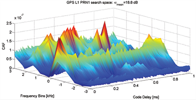
Figure 1. GPS L1 C/A acquisition search space in (a) an interference-free environment and in the presence of (b) –140 dBW in-band CWI; (c) –135 DBW in-band CWI; (d) –130 dBW in-band DWI.
Figure 1 showsthe acquisition search space for different levels of theinterfering power of a CWI from –140 to –130 dBW compared to the interference-free case. The search spaces depicted for the four scenarios are achieved using 1 ms of coherent integration time and three non-coherent accumulations, and the peak-to-noise-floor separation defined as
is considered as a figure of merit. The value of αmean decreases as the interfering power increases, thus increasing the probability of a false alarm. With the increasing power of the CWI, a modulation effect in the search space floor in the Doppler domain dimension can be observed. Such an effect is mainly determined by the new harmonics components generated by the multiplication between the locally generated carrier and received CWI. Such an effect also depends on how the interfering signal and the useful GNSS signal are combined at the entrance to the acquisition block, which in turn depends on the random variables φ0 and θint.
In the presence of WBI, a different effect is observed in the acquisition search space. Considering a band-limited Gaussian white noise spread all over the GNSS useful filtered signal components, the effect on the CAF envelop is an increase in the noise floor. This increases the search space noise floor. The presence of additive band-limited noise causes a uniform increase in the noise floor tin the search space that might mask the correct correlation peak and thus fool the acquisition process.
Impact on the Tracking Stage
Interference impact on the tracking stage has a direct consequence on the quality of the measured pseudorange. Harmful interfering signals increase the variance of the time-of-arrival (TOA) estimate by the discriminator and modify the shape of the S-curve of the code discriminator, thus creating in some cases a bias in the measurements.
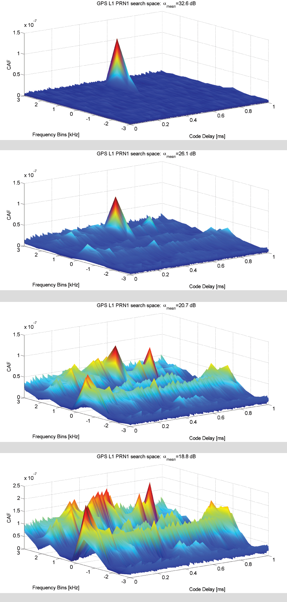
Figure 2 depicts outputs of the early-prompt-late correlators. In the presence of in-band CWI and of NBI, the interference is injected 9.3 seconds after the beginning of the tracking stage where the receiver is correctly locked on the received signal. A CWI, shifted 200 kHz with respect to the signal intermediate frequency (in correspondence with a C/A code spectrum line), increases the noise at the correlators outputs and leads to harmonic behavior of the early-prompt-late correlator outputs.
Figure 2. GPS L1 C/A code tracing error comparison: coherent and non-coherent early-late processing (CELP and NELP).
NBI increases the variance of the correlators’ outputs; this directly increases the pseudorange error and the noise on the receiver phase measurements. Additive band-limited noise leads to an overall increase in the carrier phase discriminator output variance over the 3σ threshold, which for a PLL two-quadrant arctangent discriminator is 45 degrees. When in presence of strong CWI, a sudden jump of the phase discriminator output is detected as soon as the CWI is injected onto the received signal.
Impact on the Estimated Signal-to-Noise Ratio
Sticking to the definition of C/N0 as the ratio between the received power and the power spectral density due to thermal noise at the input of the receiver, the presence of interference should not change the value, since the thermal noise is not increasing. However, the C/N0 value provided by the receivers is estimated on the basis of the correlator outputs at the tracking stage. For this reason the estimation is affected by the presence of the additional (nonthermal) noise generated by the interference. The variation of the C/N0 can also be used as observable for interference (or other threats) detection.
Chapters: The Interference Threat; Classification of Interfering Sources and Analysis of the Effects on GNSS Receivers; The Spoofing Menace; Analytical Assessment of Interference on GNSS Signals; Interference Detection Strategies; Classical Digital Signal Processing Countermeasures to Interference in GNSS; Interference Mitigation Based on Transformed Domain Techniques; Antispoofing Techniques for GNSS. The book is intended for members of the engineering/scientific community with pre-existing knowledge of satellite navigation principles and GNSS.
FabIo Dovis holds a Ph.D. in elecronics and communications engineering from Politecnico di Torino, Italy, where he is an associate professor.
First and foremost, let’s give a big hand to Adam and Anastasia, the two Galileo FOC satellites that were successfully launched on March 27. Following the not-so-successful Galileo launch in August, it was imperative that this go smoothly.
Although the Double-A launch occurred after the conclusion of this year’s Munich Satellite Navigation Summit, anticipation of the event set the context for the entire convocation. The summit is a fixture on the European and global GNSS calendar. It is always intense, often spectacular and sometimes leaves one with contradictory feelings. This year it took place March 24-26 and sought to determine the future of PNT, encouraging delegates to look into the crystal ball and predict developments.
If we go by the number of times these words were repeated during the three days of the summit, the future will hinge around compatibility and interoperability. The multi-constellation GNSS is already here. The elephant in the room remains, as always, interference, but here integration of alternative sensors and signals should hold the key to continuous and possibly resilient operations.
As usual the summit kicked off with a high-level plenary in the imposing Allerheiligen-Hofkirche (Court Church of All Saints) in the Residenz München, the Bavarian royal palace. The welcoming speeches and presentations were interspersed with some pleasant jazz, and the atmosphere was relaxed.
Into the Crystal Ball
Matthias Petschke, director of EU Satellite Navigation Programmes at the European Commission, admitted that 2014 had been difficult, but he was looking forward to 2015. Clearly the deployment of the Galileo infrastructure — especially the space segment — was critical, and the March 27 launch was very much on his mind. However, he expressed confidence that the launch would be fine and that satellite production was, and would remain, on schedule. In the long view, he stated: “We will make it for 2020,” signifying full operational capability (FOC).
He also talked about stimulating global markets to foster uptake of Galileo and EGNOS, and this was discussed by Carlo des Dorides, executive director of the European GNSS Agency (GSA). The ground infrastructure is very much in place and preparing for the Galileo exploitation phase. A significant milestone in that process would be finding the right partner to lead Galileo operations for the next ten years. A tender was now in process to find that organization or consortium. Des Dorides described the process as a competitive dialogue with the emphasis on finding a partner who can inspire new ideas and provide innovative solutions. The contract is big, worth around 1 billion euros.
Carlo des Dorides, Executive Director of the European GNSS Agency (GSA), discusses the 1 billion euro tender, now in process to find the organization or consortium to lead Galileo operations for the next ten years. Photo: GSA
He also emphasized the successes for EGNOS in the year. Almost 180 airports now benefit from EGNOS-enabled approaches and more than 70 percent of “GNSS-enabled” farmers in EU use the EU’s SBAS.
Johann-Dietrich Wörner, chairman of the German Aerospace Centre (DLR) — and the nominated next Director-General of ESA – highlighted the growing dependence of critical services on GNSS. In this context multiple systems were not a question of competition; it was all about redundancy and safety. Multi-GNSS improves availability, accuracy and reliability.
The view from the United States was given by Harold “Stormy” Martin, Director, National Coordination Office for Space-Based Positioning, Navigation, and Timing in Washington, D.C. The GPS fleet was now 30 strong in orbit including four successful launches in 2014 and he stated the 2014 averaged user range error to be 70 cms — the best ever — and improving year on year.
One major upcoming trend is a realization that there’s a need to establish a U.S.-wide backup coverage for GPS outage due to natural or man-made interference. The U.S. is currently assessing alternatives with a decision likely in summer 2015.
There was a particularly warm welcome from the audience for Michael Khailov, deputy head of Roscosmos and co-ordinator for GLONASS. Last year the Russians were conspicuous by their absence at the Munich Summit, but for 2015, despite the intervening local difficulty in Ukraine, they were back in force. Khailov claimed that the sustainable development of the world depends on GNSS. On more esoteric ground he stated that GLONASS had maintained stable operations in 2014 and three more satellites had bene launched. Further launches would depend on operational circumstances. The user domains for GLONASS were continuously expanding. Continuing the summit text he said that it was better [working] together than separately — in fact separately often doesn’t work at all and therefore we must continue to promote interoperability and the Munich Satellite Summit is a good forum for this.
Jianyun Chen of the China Satellite Navigation bureau also took up the theme of all GNSS together. Sixteen Beidou (pronounced — for the avoidance of doubt — as ‘bay-doe’) had been launched since 2007 and the Chinese had been in discussion with Russia to ensure full interoperability with GLONASS. This process will be repeated with GPS and Galileo.
GNSS Updates
One of the idiosyncrasies of the Munich Summit is its very discreet signage. If you don’t know where it is — and specifically the correct side door that brings you up two floors to the main Max Joseph Saal venue — it is highly likely you’ll miss it! But once you are in it is two full-on days of updates on systems and discussions on a vast range of topics that impinge on the development and implementation of GNSS around the world.
Discreet signage. Photo: GSA
The first two session of the summit proper gave updates on the GNSS systems in operation and under development as well as the regional and augmentation systems. Much of the material was slightly more detailed versions of presentations at the plenary but a few news snippet emerged.
“Stormy” Martin said that a modified battery charge control had been implemented that would extend operational life for some of the fleet by one or two years. He also reiterated the improving accuracy performance of GPS which was now much better that its published standards. He predicted that the first GPS III would be available for launch in 2016 and said that GPS was improving every day.
Eric Chatre from the European Commission reiterated that Galileo was still expecting to start early services in 2016 with full operational capability in 2020. He expected 18 satellites to be launched by 2018. The new Ariane 5 launcher will enable the launch of four satellites at one time and the first launch with this system would be in 2016. In terms of the ground segment only one station in the Pacific was yet to be established.
Sergey Karutin of Roscosmos talked about a four-fold accuracy improvement for GLONASS with the use of new clocks and the introduction of new CDMA signals that will improve accuracy and access. According to Dongfeng Yu of the China Satellite Navigation Office the BeiDou constellation is moving from “regional to global, active to passive” and is aiming for global coverage by 2020.
U.S. SBAS developments were covered by Deborah Lawrence of the Federal Aviation Administration (FAA). The Wide Area Augmentation System (WAAS) now has 100 percent coverage for LPV200 in CONUS. More than 41,000 runway ends are now included, and she predicted full completion in 2016.
Jean-Marc Pieplu of the GSA talked about EGNOS status. The next system release (2.4.1) should be published in Q3 2015 and will include a significant input on ionospheric corrections. Further service evolution includes a plan to declare LPV 200 in Q4 this year and EGNOS coverage will be extended to 72 deg North and ensure full coverage of the 28 EU member states.
The Russian Augmentation system SDCM performs at 0.8 metre accuracy according to Grigory Stupak of JSC / Russian Space Systems. He noted new validated SDCM ground stations had been established in Antarctica and Brazil and stated that global exploitation was a key objective for SDCM as its satellite coverage was very wide. GLONASS and GPS together could ensure complete coverage. He also indicated that work was in hand for SDCM SBAS service certification for LPV 200 and he called for providers of all WAAS to work closely together.
2020 Vision
After lunch we were offered the chance to hear some expert views on the future of GNSS and PNT with Prof Vidal Ashkenazi of Nottingham Scientific Limited asking for their vision of GNSS in 2020. By that year there should be 100-120 GNSS satellites in orbit, multi-constellation receivers would be the norm, but what would be the new applications and what were the challenges?
Jamming and spoofing would still be issues. Pierre Bouniol of Thales thought that in civil aircraft receivers would probably incorporate jamming indicators by 2020 to inform users when signals may be compromised. For Stuart Riley of Trimble the key was integration of other sensor signals to bridge any GNSS signal outage. Gang Mao of Unicore Communications Inc. in China considered multiple frequencies to be a big help in reducing the threat of jamming. Nigel Davies of QinetiQ agreed saying there were a host of technical solutions but key for success would be solutions that use low power, are low cost and feature high usability. He also noted that safety certification of receivers for use in driverless vehicles would be required and this challenging application would need the provision of robust continuous navigation — and sub-metre accuracy.
The future market for GNSS was also discussed in a session that unveiled the GSA’s 4th Issue of its comprehensive GNSS Market Report. With almost four billion GNSS devices used worldwide and all regions experiencing growth, GNSS represents an unprecedented business opportunity. Over the past 15 months the GSA’s team of market monitoring experts has taken a close look at all aspects of the GNSS marketplace with analysis of both hardware and software market opportunities, technology trends and future developments.
Gian-Gherardo Calini, Head of Market Development at GSA, gives highlights of the comprehensive GNSS Global Market report. He will deliver this information in an April 16 webinar hosted by GPS World. Photo: GSA
The top-line results were presented by Gian-Gherardo Calini, Head of Market Development at GSA. GNSS is one of the few growing markets in the world showing 12.7 percent CAGR. It is a very attractive market with volumes and revenues driven by mass market segments: the dominant two being Location-based services and transport applications. This latest edition includes information a new market segment: Timing and Synchronisation. One area that is not included is security and government applications. Mr Calini indicated that this information has been collected by the GSA team but as it is essentially for users of the Public Restricted Service (PRS) it was not included in the open report.
Although the report is very much “Galileo flavored,” its findings are of great importance and value to whole GNSS community and will be the subject of a GPS World webinar with Mr Calini and myself on 16 April. You can register — free — for this informative global perspective now.
A panel discussion followed and covered a range of topics and applications from aviation to agriculture. Again the consensus was that chips would become multi-constellation and quickly. Philippe Prats of STMicroelectronic outlined automotive applications from insurance applications to advanced driver assistance systems (ADAS).
The role of government mandates in establishing markets was seen as positive. The e911 mandate in the states had provided the seed for GPS integration into smartphones. Similarly authentication was also seem as a significant future market driver.
Multi frequency was also showing on industry’s radar and in a couple of years will be a reality thought Philippe Prats with the main motivation being better accuracy. Frank van Diggelen of Broadcom highlighted the recent GPS World feature demonstrating cm accuracy on a smartphone.
Legal Issues
A dedicated session on legal issues was not the best attended part of the conference, which is a shame as it had some serious points to raise and highlighted a gap that is opening up between our technical abilities in GNSS and the legal basis for its use. The Munich Summit is to be commended for its commitment to providing a platform for these issues every year; they are often ignored elsewhere.
Oliver Heinrichs, a partner at BHO Legal in Cologne, emphasised the need to establish a firm regulatory framework and to ensure that any decisions did not cross World Trade Organisation (WTO) provisions and the General Agreement on Tariffs and Trade (GATT). In particular the idea of mandating a specific GNSS for applications such as emergency response systems in cars may well be incompatible with WTO rules.
Amedeo Arena of Universitá degli Studi di Napoli Federico II in Naples noted that all GNSS players were members of the WTO and considered that GNSS services and their trade was definitely “caught by the GATTs” so no favouritism for ‘home’ systems should be allowed.
Another area of controversy is automated vehicles. In discussion after the session I learnt that current international conventions governing the use of motorised vehicles require a human supervisory role at all times. There will need to be some fundamental legal groundwork done before the first driverless vehicles will be allowed out on the road for real.
These are legally complex issues and certainty will only come from test cases. Talking of complexity Aleksey Bolkunov of the Russian Federal Space Agency revealed that the legal, regulatory and standardisation measures governing GLONASS and GNSS in Russia consisted of more than 900 documents originating at various different levels of the state. This clearly gave great scope for “regulatory collisions” and he is involved in work to develop a single regulatory framework that should eliminate the remaining barriers to GNSS use in Russia.
Emerging Applications
Peter Grognard of Galileo Services chaired a final session of the day on emerging applications. Bruno Bougard of Septentrio saw dependable accuracy as key to emerging markets. He thought high precision driven by surveying was becoming more and more mainstream. For autonomous driving the challenge was to provide cost-effective, dependable accuracy at 10-30cm that was safe, reliable, and always available. This would require multi GNSS, multiple signals, highly integrated sensors and transparent and open augmentation.
For Neil Gerein of Novatel the mantra is “Accuracy, availability, assurance.” Users needed availability to their PNT solutions at all times. He also saw future applications integrating GNSS with inertial sensors and correction systems for high accuracy without the need for a base station.
or Neil Gerein of Novatel the mantra is “Accuracy, availability, assurance.” Photo: GSA
Lionel Garin of Qualcomm Inc talked about ADAS. Safety was paramount and he foresaw the need for rigorous design and certification procedures similar to that required for the aviation market. Fortunately the industry has lots of expertise here. Philip Mattos of u-blox UK argued that a volume market is in femtocell and small cell synchronisation in mobile networks where GNSS is the lowest cost solution.
Tom Stansell praised geometry as the most important and unique ingredient supplied by multi constellation GNSS. And the second most important ingredient was interoperability. He doubted users would care where their signals originated and devices would still be generically described as ‘GPS’ into the future. Application growth will be stimulated by the better geometry supplied by multi-GNSS constellations. When the E6 signal became available he predicted that 10cm accuracy would enable reliable lane keeping for ADAS.
And Galileo will supply E6 for free said Ignacio Fernandez Hernandez from the European Commission. Ignacio works on the Galileo Commercial Service design and outlined some significant differentiators of the European system including its broad signal for high accuracy and better multipath resilience, more stable clocks and improved ionospheric modelling compared to GPS.
Lionel Garin sounded a note of caution at the end of the session when he noted that multi constellation ability was good, but he was not sure what was actually gained beyond two, or perhaps three, constellations.
GNSS for Weather
The final day of the conference saw a few fragile heads courtesy of the previous evening’s Summit Space Night 2015 sponsored by Airbus Defence & Space, which took place at the Filmcasino am Hofgarten close to the conference venue. And the first session, chaired by Oliver Montenbruck from the DLR, certainly required a clear focus as we were taken through the use of GNSS in space geodesy, space navigation and reflectometry.
Roland Pail from the Technical University, Munich described results from the satellite gravity missions GRACE and GOCE that looked at mass transport processes on our dynamic Earth. A particularly sobering animation showed the extent of ice mass loss from Greenland over the past decade. But what is role of gnss here? The ability to give precise positioning of the satellites and the fact that the satellite orbits carry information on the gravity field.
Atmosphere sounding using GNSS radio occultation allows precise atmospheric profiles with global coverage in all-weathers. Jens Wickert of the Helmholtz Centre Potsdam said that since 2006 these high vertical resolution profiles had been making a significant impact on the world’s weather forecasting including improved hurricane forecasts. It was also a bias free technique for observing global temperature change. With a multi-GNSS future new missions could be planned as more signals would reduce noise. Combining GNSS and reflectometry could enable accurate tsunami detection from space. Similarly Prof Antonio Rius from Barcelona was using reflected GNSS signals to determine data on the surface of the sea such as surface roughness, extent of sea ice and early warning of a tsunami.
Stefan Sassen of Airbus Defence & Space described the LION GNSS navigation receiver for MEO and LEO platforms. The unit was qualified since 2014 and now 50 were on order. LION is highly flexible with multi-frequency, multi-constellation and multi-antennae configurations possible. It was accurate enough for autonomous orbit raising (a few kms) and or station keeping (to within 100cm).
Finally Manfred Sust of RUAG Space GmbH said that space borne gnss receivers were true enabling technologies for Earth Observation missions as precise orbit determination was key to capturing sharper images.
Alternatives
The second session of the day returned to the practical issues around possible alternative or complementary PNT (APNT) systems. As GNSS becomes ubiquitous many terrestrial PNT systems are being decommissioned (LORAN, VOR), but the potential vulnerability of GNSS signals to interference is highlighting the need for backup. The challenge being to balance functionality and cost in the search for “plan ‘B’ for GNSS” as chairman Michael Meurer from DLR described it.
The FAA’s Deborah Lawrence reiterated her plans for scoping and implementing a backup system to cope with a GPS outage in the US. The FAA is currently engaging with stakeholders to define what the minimum operational target for a GPS outage should be to set the basis for procurement activity. The timeline for a final investment decision was now December 2018.
For Europe Gerhard Berz of Eurocontrol thought there were many potential APNT in place and the topic was in the SESAR 2020 research programme. He thought existing DME could potentially do the job in Europe as it had good coverage, but the challenge is to get good geometry and coverage at low altitudes, in remoter areas and over water.
Prof Per Enge of Stanford University “put the moose on the table” and pointed to the 978 and 1030 ranging frequencies as an existing system that could be used for positioning. But how accurate was it? Airborne experiments had shown good agreement with GPS positioning with an accuracy of around 100m and in turns 300m, which was good enough in an emergency. Further tests using a UAV at spider infested Camp Rogers had demonstrated APNT in flight with 50m error. The UAV itself was specifically developed to navigate using APNT while looking for GNSS jammers.
Wouter Pelgrum of Ohio University discussed the relative merits of eLORAN, which has high power – and therefore difficult to jam – and beyond line of site accuracy of less than 10m, and alternatives such as collocation of pseudolites with mobile phone cell towers. This could also enable high accuracy indoors positioning applications. He believed that APNT will need to be context specific and there was no single solution.
Belabbas Boubeker of the DLR discussed modular APNT concepts while Nick Ward of the UK’s General Lighthouse Authorities indicated there was no coordinated policy on resilient PNT in the European maritime sector at present but his authority and others were exploring the possibility of using eLORAN as a commercial enterprise. Nine transmitters were operational in Europe and the service had been declared in 2014.
Michael Hoppe of Fachstelle der WSV für Verkehrstechniken said resilient PNT was a core element of e-navigation for waterways. A combination of techniques such as medium frequency RF, AIS and eLoran could give good accuracy in areas of highest traffic. First results of trials were encouraging.
Processing Power
The final session of the Summit to grab my full attention was chaired by Frank van Diggelen of Broadcom. He led a wide ranging debate on GNSS receiver architecture trends and more generally the future of chip design and fabrication: are we approaching the end of Moore’s law and if so — what next?
Recently “The balance of power has moved back onto the GNSS chip” to enable lower device power use. To highlight current developments Frank described a couple of Broadcom products: the Broadcom 4773 “location hub” that is at the heart of the Samsung Galaxy 6 “super smart phone” and the 4774 that can access signals from all four GNSS constellations and will be shipping in early 2016 on new smartphones.
In fact earlier this year the 4774 was used to make a first fix using signals from four different GNSS constellations (with signals from one each of GPS, GLONASS, Galileo and BEIDOU satellites) and a significant event in terms of our multi-constellation future.
Greg Turetzky of Intel talked about the benefits and challenges for GNSS in advanced silicon processes. He noted that Intel is now shipping 14nm technology and plans were in hand for the next two generations (10nm and 7nm). Moore’s law has been a great enabler for modern society. If automobiles had taken a similar development in the same timeframe we would all be driving cars with a maximum speed of some 300 000 km/hour that cost us around 4 cents to buy!
The big challenge for GNSS architecture was to take advantage of the smaller geometries while greatly reducing standby power. The integration of multiple radio sources to provide a single location solution was key giving ubiquitous location capability that will improve the experience of every mobile product.
Looking into his crystal ball, Peter Anderson of Integrated Navigation Systems in the UK saw that integrating signals from complimentary technologies and sensors would be important but would lead to a greater demand for digital processing. He predicted that multiband receivers would become standard in consumer devices. He also pointed out that the worst potential source of GNSS jamming for a smartphone was the phone itself! The move to dual frequency would be helpful here.
An overview of the Chinese XIHE system for seamless outdoor and indoor location was given by Dongkai Yang of Beihang University. This Beidou Innovative application provides a LBS system based on gnss and mobile communication networks to give a “fusion of communication and positioning for indoor positioning”. The system is being demonstrated in four areas in China in shopping malls. The target for positioning accuracy in the system is for less than 3 metres indoors and less than 1 metre outdoors.
Franz Kreupl of Munich Technical University gave a sobering view of “life after silicon” – essentially it looks like there isn’t one. He outlined the limits to silicon technology such as tunnelling current and predicted some further progress could be made in reducing interconnect sizes and via circuit design. But new candidate materials for semiconductor electronics from carbon nanotubes to widely hailed 2-D materials graphene and MoS2 all suffer major issues that seem to make them non-starters.
But do we need to keep on miniaturizing? Norbert Schuhmann of Fraunhofer IIS in Nuremberg thought that technology downscaling would have an end in terms of the physics, but especially in terms of reasonable cost. He thought 7nm and 2020 was the end point for the physics but that in fact 28nm should be seen as the actual last node in Moore’s law as from then scaling has no longer also been the path for cost reduction. He saw silicon on insulator technology and monolithic 3-D integration as possible paths forward, but the technology sweet spot — and well suited for GNSS — was 55nm and a format that was already extensively used in automotive applications.
A bi-partisan group of legislators led by Congressman John Garamendi (D-Calif.) has introduced a bill that would require the U.S. Secretary of Defense to establish a backup for GPS within three years using eLoran.
The National Positioning, Navigation, and Timing Resilience and Security Act of 2015, H.R. 1678, was co-sponsored by Congressmen Duncan Hunter (R-Calif.), Peter DeFazio (D-Ore.), and Frank LoBiondo (R-N.J). Garamendi is the ranking member of the House Transportation and uInfrastructure Subcommittee on the Coast Guard and Maritime Transportation.
H.R. 1678 would require the secretary of defense, in coordination with the commandant of the Coast Guard and the secretary of transportation, to establish and sustain a reliable, land-based positioning and navigation system that will complement and backup America’s GPS for military and civilian uses by using eLoran.
eLoran is the government’s existing and underused long-range navigation system infrastructure. The backup system would step in when GPS signals are corrupted, degraded, unreliable, or otherwise unavailable. A terrestrial-based system, eLoran wouldn’t be affected by atmospheric interruptions such as solar storms, or jamming or spoofing aimed at GPS.
The bill directs the secretary of defense to incorporate the expertise and contributions of the private sector to quickly establish system architecture, as well as build and operate the system.
“GPS is much more than a LCD screen on your dashboard. It’s a technology used for much of our nation’s critical infrastructure and by almost every major industry in America, as well as the military, law enforcement, and first responders,” Garamendi said in a press release. “We are increasingly reliant on the precision, navigation, and timing services that GPS provides. From land navigation on cell phones to a timing source for our national infrastructure, we need a reliable backup system to GPS.”
Garamendi said the bill would make the nation’s geopositioning infrastructure more resilient to “threats both natural and nefarious.” “A backup system could also reach places that GPS currently cannot, such as inside many buildings. This would help first responders and law enforcement more effectively protect the public,” he added.
Other members of Congress are expected to sign on as co-sponsors after Congress returns from its spring recess, according to Dana A. Goward, president and executive director, Resilient Navigation and Timing Foundation.
The eLoran PNT system would use enhanced long-range signals (eLoran) from 19 towers around the country, each with approximately a 1,000-mile range providing overlapping fields from which a device can derive its location. The back-up system would use the remaining Loran infrastructure and provide a secure and reliable cybersecurity insurance policy, said the press release.
The U.S. atomic clock, accurate to one second in 300 million years, also serves as the base timing source for this backup GPS capability. This exceeds the timing needs of modern cell phones, creating an infrastructure backbone that is prepared to handle the evolution of consumer and industry electronic communications in the years ahead, the press release said.
The bill sets out numerous requirements for the system, saying that it shall:
Be wireless, terrestrial, and wide area
Provide a precise, high-power 100 kilohertz signal
Be resilient and extremely difficult to disrupt or degrade
Be able to penetrate underground and inside buildings
Take full advantage of existing, unused Loran infrastructure
Work in concert with and complement any other similar positioning, navigation and timing systems, including eLoran.
Since 2004, the federal government has recognized that the absence of a reliable backup system for GPS is a glaring economic and security threat to the United States, and has reaffirmed its interest in developing an eLoran as a reliable, land-based backup for GPS signals, the press release said.
In January, the United States Army began soliciting information for eLoran receivers for the warfighter, either stand-alone or integrated with GPS, for use in Army and other Department of Defense maritime, aviation, or vehicular platforms, and for position and timing.
The United Kingdom began using eLoran in October 2014 to protect its shipping lanes, which carry 95 percent of UK trade, in case of GPS signal loss.
GPS World will host a webinar this Thursday, March 19, on the merits of using simulated jamming, spoofing and interference scenarios to prepare GNSS receivers for the brave new world of coping with adverse signal effects. It’s clear that users need to still operate commercially and individually, even when they get hit by extraneous interference — intended or otherwise — in a world where cigarette-lighter jammers, engineering “lash-up” spoofers, and badly designed commercial gear can ruin a person’s day.
Recently, I had a conversation with Guy Buesnel, market segment manager, GNSS Vulnerabilities, at Spirent Communications. He wanted to alert me to the concept that jamming and spoofing is at a stage where Internet hacking was many years ago. Hacking has progressed from the typical loan student in his bedsit or studio apartment pounding on a keyboard to break down banking or other institutional firewalls, to nowadays, where focused groups mount hacking attacks on targeted agencies or companies lasting days, weeks, even months. Huge effort is currently being applied to defending against these and future focused attacks.
Buesnel’s point is that organized attacks on GNSS may be coming, and coming soon. Individuals and groups are already self-jamming to prevent detection — organized car and truck thieves wanting to avoid location of stolen assets, or truck drivers wanting to prevent their employers knowing their whereabouts — using easily obtained “personal cigarette lighter” or even professional-looking jammers (see figure below). Jamming GPS L3 at 1381.05MHz might awaken U.S. Department of Defense (DOD) interest as it’s used by the Nuclear Detonation (NUDET) Detection System Payload (NDS), and L4 at 1379.913 MHz is currently only used for studies on additional ionospheric corrections.
But Buesnel warns that organized spoofing could soon start to happen, and happen frequently. And it could be argued that spoofing is more dangerous than jamming, because a user or someone monitoring a user might not know for some time that their position information has been compromised. Long enough, perhaps, for an unwary user to get into potentially serious trouble, especially in a higher speed, fuel-restricted application like an aircraft or a small boat running some distance offshore.
GNSS is already embedded into the critical infrastructure of utility providers, and also telecoms, financial and transport sectors for timing/synchronization or positional data, and the growth in vehicle automation will soon see GNSS being used for even more safety-critical applications. The security of GNSS is already of huge importance and a “GNSS hacking attack,” like those experienced by Internet users, could achieve significant disruption across a host of operational segments. Precise GNSS timing is already essential for time stamping some transactions and used extensively for cell-site synchronization, so significant damage could occur if timing information were to be compromised.
While an intentional spoofing attack has yet to be confirmed — except under conditions such as that drone spoofing demonstration and then the White Rose luxury yacht spoofing trials, both by University of Texas/Cockrell School of Engineering graduate students — unintentional spoofing has indeed been reported. GNSS repeaters radiating at higher power levels than actual GNSS signals can be the source of such spurious signals. The result can be that GNSS receivers may acquire and track the higher power repeater signals, and the receiver position becomes that of the repeater. Use of GPS repeaters in unsuitable locations, such as for production tests in an open workshop, have been reported. The risk is that GNSS signals could extend outside the building and affect users, so GPS receivers could be spoofed and tricked into reporting an incorrect position.
White Rose 213-foot luxury yacht. Photo: Tony Murfin
For more than 20 years, the information security community has debated publishing the methods used by hackers and others to expose and attack vulnerabilities within products. Initially, things were kept hidden and were only shared between groups of hackers or IT administrators. However, online hacker forums quickly distributed knowledge — often including sample code. This allowed everyone from security researchers and IT administrators to hackers to learn about the vulnerabilities of applications and critical systems. It would seem that both researchers and hackers alike have broken the spell, and now it’s easy to spread the word about backdoors and weaknesses in firewalls, critical applications and the like.
Fast forward, and we are now in the age of mass-market access to jammers of all kinds through offshore websites — even if it’s illegal to operate such devices. However, it’s also illegal to hack the Department of Defense, but that has not prevented hackers in the past from assaulting and penetrating all sorts of secure DoD computing facilities. So, let’s just assume that the individuals who get a kick out of creating mayhem may eventually turn to something new — and the age of jamming and spoofing for fun may be upon us.
All is not lost, however. Just as applications for finding and killing viruses have become more robust, and new “antidotes” and warnings are now automatically downloaded to your PC even as they are created, and huge amounts of effort are now being applied to creating the most robust firewalls, so the designers of GNSS receivers are working hard to immunize their systems against anticipated attacks. And simulator/replay manufacturers such as Spirent Communications, IFEN, Spectracom and Racelogic are developing and fielding ready-made spoofing and jamming capabilities and scenarios with which manufacturers can test and qualify their receivers — which you may well hear about during the coming GPS World webinar on March 19.
Nevertheless, some people in the industry are urging members of the GNSS community to act more cooperatively and report spoofing and jamming incidents/attacks for their own good. It seems that the industry only collaborates in the face of a major common threat — take the ultra wideband and LightSquared episodes where the response was virtually unanimous. While most GNSS manufacturers in the meantime tend to maintain a very proprietary cover to their field experience and technological solutions, this still leaves customers exposed to product vulnerabilities. The GNSS community now has the advantage that the information security community has been working through these hurdles for the past two decades. Lessons learned include the following:
Controlled, responsible disclosure and cooperation allows everyone to monitor the threat and how it is being dealt with.
Without restricted disclosure and preventive solutions, attacks will always take advantage of weaknesses.
Eventually, disclosure of product vulnerabilities will result in more respect and confidence in manufacturers by users.
Rapid resolution of issues is essential.
The GNSS community has an opportunity to come together, learn from the information security community, and adopt best practices to secure and protect its customers.
(With grateful thanks to Guy Buesnel and David DeSanto of Spirent Communications!)
KVH Industries, Inc., has received a $4.3 million order for its TACNAV tactical navigation systems from a new customer who is a major defense contractor providing armored vehicles for an international military client. With a short delivery requirement, shipments for this order are expected to be substantially completed in the fourth quarter of 2014.
“KVH is extremely pleased to be selected by another major defense contractor to provide the tactical navigation solution for their new armored vehicles. Providing precise navigation as well as coordination of vehicles in critical situations is an important tool that helps keep soldiers oriented wherever they operate,” said Dan Conway, executive vice president of KVH’s Guidance and Stabilization group.
KVH’s TACNAV military vehicle navigation systems provide unjammable precision navigation, heading, and pointing data for vehicle drivers, crews, and commanders. TACNAV can also serve as a heading and position source for situational awareness.
In October, KVH received a $19 million contract for the delivery of a new fiber optic gyro-based tactical navigation system for use by an international military customer in an armored vehicle application.
TACNAV systems are in use by the U.S. Army and Marine Corps, as well as many allied customers including Canada, Sweden, Great Britain, France, Germany, Spain, Egypt, Botswana, Australia, New Zealand, Saudi Arabia, Taiwan, Romania, Poland, Turkey, Malaysia, Switzerland, South Korea, Singapore, Brazil, and Italy.
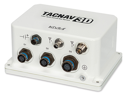
The TACNAV 3D, by KVH Industries. Photo: KVH Industries
KVH Industries, Inc., has received a $19 million contract for the delivery of a new fiber optic gyro (FOG)-based tactical navigation system for use by an international military customer in an armored vehicle application. A variant of KVH’s TACNAV FOG product and KVH’s new TACNAV 3D, the system provides continuous high-accuracy position and orientation even when GPS is lost or jammed.
Work on the contract began in July under a letter contract, and hardware shipments for this order are expected to be made in 2015 and 2016. Program management, engineering services, and out-year support services will be provided as part of this order.
“KVH’s TACNAV navigation solution is an important tool for U.S. and allied warfighters, providing precision navigation as well as coordination of vehicles in critical situations,” said Dan Conway, executive vice president of KVH’s Guidance and Stabilization group. “The system serves as a crucial resource for navigation and battle management, and even as a backup in GPS-denied environments, keeping soldiers safe and out of harm’s way wherever they travel. This new order reaffirms the value of KVH’s TACNAV products for international militaries, and adds to our backlog for the coming years.”
All of KVH’s TACNAV military vehicle navigation systems provide unjammable precision navigation, heading, and pointing data for vehicle drivers, crews, and commanders. TACNAV can also serve as a heading and position source for situational awareness. The TACNAV system ordered is a FOG-based navigation and pointing solution, which is designed to ensure precise navigation data regardless of GPS availability as well as automatic “drive and calibrate” capability. It features a compact design, continuous heading and pointing data output, and a flexible architecture that allows it to function as either a standalone navigation module or as the heart of an expanded, multifunctional TACNAV system. The system is designed to integrate with Battle Management Systems (BMS) and is a vital component for effective battlefield management.
TACNAV systems are currently in use by the U.S. Army and Marine Corps, as well as many allied customers including Canada, Sweden, Great Britain, France, Germany, Spain, Egypt, Botswana, Australia, New Zealand, Saudi Arabia, Taiwan, Romania, Poland, Turkey, Malaysia, Switzerland, South Korea, Singapore, Brazil, and Italy.
In recent tests, the IDS ran continuously for 24 hours monitoring for potential interference originating from traffic on a nearby highway, SR-522, passing through Woodinville, Washington. “In a single day, the IDS detected two separate instances of a sweep jammer moving along the highway,” noted Loctronix Founder and CEO Michael Mathews. “These discoveries were unexpected, given the relatively short monitoring period and the fact that SR-522 is not a heavy truck-route.”
“The two interference events were likely caused by sweep jammers installed within a vehicle’s interior. The intercepted signals exhibited significant variations in amplitude probably caused by the jammer antenna non-uniform radiation pattern as the jammer vehicle passed through the IDS antenna beam pattern,” Mathews added.
Intentional interference is designed to prevent a GPS receiver from acquiring and tracking signals. The use of jammers is in the U.S. is illegal; however, they can still be purchased for as little as $30. Thousands of GPS jammers are purportedly in use throughout Europe and several parties have been caught illegally jamming GPS in the U.S.
Loctronix developed the IDS to identify, characterize, and ultimately geolocate GPS interference. When interference is present, the system analyzes the interference for signal structure and notifies operators if the threat is significant.
The IDS is highly portable, simple to use, and cost-effective, Loctronix said. The system is based upon the Loctronix ASR-2300 software defined radio platform, making it readily configurable (from a single mobile detector to a multi-sensor network array) to monitor additional GNSS bands and, potentially, cellular bands.
In the video below, Michael B. Mathews, Ph.D., CEO and founder of Loctronix, tells GPS World about the IDS at the ION GNSS+ Conference, held September in Tampa, Florida.
In May 2011, Dinesh Manandhar and Hideyuki Torimoto of GNSS Technologies, Inc., Japan, penned a very interesting article in GPS World titled – Opening Up Indoors: Japan’s Indoor Messaging System, IMES. The opening paragraph of their lengthy article seemingly describes the Holy Grail for the indoor positioning lobby:
“An indoor messaging system (IMES) has been developed to meet the challenges of indoor and deep indoor positioning, as a system that can be implemented in any device that has a GPS/GNSS receiver without hardware modification. IMES can provide reliable 3D position data with a single transmitter device without performing range calculation[s].”
They go on to describe the IMES concept thusly:
“The main concept of IMES is to transmit position and floor ID of the transmitter with the same RF signal as GPS. IMES transmits latitude, longitude, height, and floor ID by replacing the ephemeris and clock data in the navigation message of GPS. A single unit of IMES is enough to get the position data, since the position itself is directly transmitted.”
Now, you don’t have to be a rocket scientist to start thinking about interference and spoofing issues or risks, especially when you read that the navigation message ephemeris and clock data are being replaced by data broadcast by IMES. To be fair, the authors address these issues briefly:
“Since IMES shares the same frequency as [the] GPS L1 band (1575.42 MHz), there is an interference level that IMES may have on GPS signals. This interference has been studied in detail by conducting experiments and simulations. Based on these studies and analysis, various methods have been considered to avoid harmful interference to GPS signal. To avoid such interference, IMES center frequency is shifted by +/– 8.2 KHz from GPS L1 band. This will have the least impact on the GPS L1 band signal. For example, if the IMES signal is –110 dBm (very strong) and the GPS signal is –142 dBm (very weak), the loss of GPS signal (C/N0) due to IMES is less than 2 db. If the IMES signal is –120 dBm and the GPS signal is –142 dBm, there is no loss of GPS signal (C/N0). Based on this analysis, the IMES transmitter power must be controlled such that the maximum power to the receiver does not exceed –110 dBm at a distance of 3 meters from the transmitter. [There are] guideline[s] specified in the QZSS IS document for setting the transmitter effective isotropic radiated power (EIRP) based on location.”
Let’s put these concerns in perspective. I thoroughly enjoyed the article and firmly believe that we desperately need to solve the indoor positioning and navigation problems, especially for our warfighters and first responders. While many of today’s excellent commercial receivers work well indoors near windows and doors, they are absolutely abysmal underground and deep inside large buildings with lots of metal, or in the middle of dense urban canyons such as Tokyo, Japan. Without a doubt, there is a dire need for a system like IMES — or maybe exactly like IMES — but there must be some caveats and stipulations as to how the IMES system is implemented.
Not Alone
Fortunately, I am far from being a lone wolf in voicing my concerns and my position, for once again the conspiracy theorists as well as renowned scientist and policy makers are concerned about IMES and the operating systems they supposedly desire to replace or augment. Chief among them is the Father of GPS, Dr. Bradford Parkinson, who has frequently described improperly operated in-band pseudolites as “…just another name for a legal jammer or spoofer.” Having known Brad for almost 40 years, I am convinced few GPS experts in the world today have as much experience with pseudolites as Dr. Parkinson. Consequently, the very reason that an indoor navigation system such as IMES is needed may well be a portent for why it may well fail, unless it is implemented properly.
It would be easy but extremely tedious to write about the numerous issues facing IMES in a complicated and technical manner. Certainly previous articles have become bogged down in minutia, and I want to avoid that. It is actually very simple. The issues are fairly straightforward and should be faced head on and not hidden in the midst of tech-speak lingo, legal jargon, policy minutia or politics. So lets dive straight in, shall w,e and make sure these issues see the light of day?
Interference
There can be no doubt that IMES has the potential to significantly interfere with GPS and QZSS signals. The authors of the IMES article are quite clear concerning the potential for interference, and in their own way attempt to mitigate it with signal power restrictions. Their example of a small three- to four-story building with IMES transmitters may indeed be adequate for signal power mitigations, but what happens in Tokyo where tall buildings — skyscrapers if you will — abound? When the Tokyo Skytree skyscraper opened to the public in 2012, it was then listed as the world’s tallest tower and Japan’s biggest new landmark. At over 2,080 feet tall, this is definitely the type of building where one would need an IMES system. With an average of 20 IMES transmitters per floor and weighing in with over 200 floors, we can quickly see that there would be over 4,000 IMES transmitters in this one building alone, all broadcasting simultaneously on or near the center frequency for GPS. Absent stringent regulations and infinite care (the IMES article authors propose that the pseudolite network operator will have the responsibility to continuously monitor each pseudolite and the pseudolite network to prevent interference), and perhaps even with those caveats in place, the GPS L-band noise floor would be such that GPS signals would be incapable of being received.
Now, put 20 such buildings in a ten-block area and the noise floor would be almost incalculable and certainly not predictable. Dr. Parkinson’s fears are realized; your legalized IMES system becomes a distributed network of jammers and/or spoofers. However, technically IMES is currently far from being a legal jammer or spoofer as currently IMES transmitters are not legal to operate in the GPS band at 1559-1610 MHz under the International Telecommunications Union (ITU) Treaty per the International Table of Frequency Allocations of the ITU Radio Regulations. The ITU further states that IMES currently operates on an interfering basis with the co-primary allocations (ARNS/RNSS) in this band, and therefore are in violation of the ITU Treaty. However, Japan’s frequency regulatory agency can develop and implement regulations that allow IMES operations. When this occurs, if not operated within stringent guidelines, IMES could then be considered a legalized jammer or spoofer.
Even the Joint Research Centre of the European Commission, the JRC, states in its Executive Summary on pseudolites that in-band pseudolites pose a significant jamming risk to GNSS receivers. Specifically they state:
Pseudolites or pseudo-satellites are an emerging technology with the potential of enabling satellite navigation indoors. This technology found several applications that are not limited to indoor navigation. Precise landing, emergency services in difficult environments and precise positioning and machine control are few examples where pseudolite technology can be employed.
Despite the great potential of this technology, severe interference problems with existing GNSS services can arise. The problem can be particularly severe when considering non-participating receivers — legacy devices not designed for pseudolite signals. The design of pseudolite signals is thus a complex problem that has to account for market requirements (modifications of existing receivers for enabling the use of pseudolite signals, measurement accuracy, target application), regulatory aspects (frequency bands to be allocated for pseudolite services) and interference problems.
JRC investigates the main aspects to be considered for the design of a pseudolite signal standard minimizing the interference problem without compromising the location capabilities of the system. The focus is on the signal characteristics and topics relevant for the signal design.
Pseudolite or Communications System
The second technical portion of the interference issue revolves around how exactly you define IMES, for when you are dealing with radio regulation agencies semantics matter. Think back to the first paragraph of this article where the IMES authors defined IMES as a messaging system. That certainly sounds like a communications system to me, and others agree. Consequently, the question has been raised and rightfully so: Is IMES a navigation and positioning system, a pseudolite or a communications system? Honestly, to me it sounds like a bit of all three, but if you define it as a communications system, then Japan is seeking to authorize the integration of a communications system with known significant interference issues with GPS signals right in the middle — indeed, potentially on the center frequency of the protected navigation band using terrestrial PRN codes assigned by the U.S. government. If IMES is deemed an indoor pseudolite, then the interference issues are still there. But it is defined as a bonafide PNT system using authorized terrestrial PRN codes. Talk about a bucket of worms!
The issues here are numerous, and they need to be fully addressed to ensure that all those who are potentially affected clearly understand what is being proposed and the risk for the public at large, including who owns responsibility if something goes wrong. I could go on for several pages on this issue alone, but suffice it to say, we do not want to authorize a communications system that is a known and acknowledged GPS interferer right in the middle of the band — or anywhere in the band for that matter. Remember all the issues GPS had in the past several years with a communications system in adjacent bands. So, do we really want a known communications system — or communications system masquerading as a pseudolite, for that matter — with known GPS signal interference issues in the restricted GPS frequency spectrum? The blaringly obvious answer is absolutely not! Yet this is exactly what the IMES authors are proposing not only for Japan, but eventually, if they receive authorization, for other countries around the globe as well. Japan has twice petitioned the U.S. government to make the assigned IMES terrestrial PRN code allocations global in nature. Fortunately, to date those request have been denied.
Dichotomy
Certainly, other countries and companies have noticed this apparent frequency authorization dichotomy and are following suit. For instance the Conference of European Postal and Telecommunications agencies, or CEPT, which is Europe’s regional representative to the World Radiocommunication Conference (WRC), has proposed adding several troubling IMES-related agenda items for the quadrennial WRCs coming up in 2015 and 2019. Even more importantly, these critical issues could be aired in the next three weeks, as the agenda for the 2015 WRC will be largely set at a plenipotentiary conference happening October 20 through November 8 in Busan, South Korea.
There are what I consider to be dangerous proposals under consideration by the ITU (International Telecommunication Union), which should concern GNSS users worldwide. The ITU is the United Nations’ specialized agency for information and communication technologies — ICTs. This is the ITU, where every member state (currently 193) gets one vote, whether they fully understand the technical issues or not and regardless of whether they are a space-faring nation or have a dog in the fight, so to speak. This means that the vote of tiny Saint Lucia counts the same as the United States or Canada or Australia. The ITU charter is to “…allocate global radio spectrum and satellite orbits, develop the technical standards that ensure networks and technologies seamlessly interconnect, and strive to improve access to ICTs to underserved communities worldwide.” Fortunately, the ITU regulations, unlike the CEPT or IMES proposals, wisely require new transmitters proposing to operate in the radio navigation spectrum to operate without causing interference to primary users. Meanwhile, there are member states, countries and companies that want to capitalize on this seeming dichotomy within the global safety-of-life, historically protected, radio bands. Those nefarious efforts, for the future of GPS and GNSS worldwide, need to be stopped in their tracks.
Spectrum is a limited and valuable resource, to say the least, and here fortunately the ITU regulations have it right and do not risk human life, by intruding and potentially interfering with the frequencies used globally by airliners to control, route and land aircraft. I am convinced there are solutions available to us through cooperative efforts with the ITU and other national organizations that will produce pseudolites without causing interference in the protected safety-of-life frequency bands.
When Is a PRN Code Not a PRN Code?
Some of you who are a bit more savvy or have been following this fiasco for some time may now be thinking, what’s the problem, the IMES authors are merely using and proposing further use of U.S. government-authorized terrestrial PRN codes for IMES. This indeed touches on the third thorny issue, which is not only technical but political as well — the use of and authorization to use PRN codes for what is ostensibly a communications system, if you believe the authors of the IMES article, who go to great lengths to differentiate IMES from pseudolites. They continually make the argument that IMES is not a pseudolite, but as we shall soon see, when the U.S. government authorized these specific PRN codes (173-182) for Japan, they were to be used solely for a low-power terrestrial pseudolite program, not an in-band communications system.
Technically, these specific PRN codes assigned to the Japanese for IMES expire in 2017. The authorization of these PRN codes come with numerous restrictions that legally make the codes useful only for the Japanese landmass. This is where the technical, political and operational issues come to a head. We are in for some tough sledding here. However, I will endeavor to make it as simple as possible.
History
In 2007, ten PRN codes were specifically assigned to the Japan Aerospace Exploration Agency or JAXA “for the Indoor Messaging System (IMES) terrestrial pseudolites of the Quasi-Zenith Satellite System (QZSS).” The Memorandum of Agreement from the GPS Wing at SMC (Space and Missile Systems Center) in Los Angeles at Los Angeles Air Force Base (LAAFB) clearly states that the codes are valid for ten years and expire on 19 November 2017, unless a renewal application is filed and approved. Hence, PRN codes 173-182 for IMES were assigned with several crucial caveats and restrictions by the U.S. government that are definitely pertinent to our discussion:
The codes are designated for low-power terrestrial regional applications limited to Japan only.
Although the GPS Wing conducts an initial check on PRN number requests with respect to potential interference issues, the issuance of a PRN number does not convey authority to radiate in the [GPS] band. In order to radiate in the GPS L1 band, the applicant [Japan] shall obtain a frequency assignment from the [Japanese] national authority.
The GPS Wing assumes no responsibility for ensuring systems using these spreading codes follow domestic radio frequency regulations or other applicable laws or regulations, or for ensuring that systems using GPS PRN codes do not cause radio frequency interference.
GPS PRN codes were developed for signals transmitted from satellites, and are not necessarily optimized for use by terrestrial transmitters.
The maximum effective isotropic power for each terrestrial transmitter will be less than -94 dBW.
The QZSS [organization] is responsible for the redistribution of these spreading codes throughout Japan and will limit their use to Japan only.
With all these restrictions, it is difficult to see how the IMES authors could legally use, distribute or promote authorization of IMES and the use of the PRN codes outside of Japan and at the power levels related in the GPS World IMES article. Regardless of the IMES author’s interpretation of the PRN code assignment, the GPS Wing 2007 Memorandum restrictions and caveats are clear, and it cannot be disputed that the codes expire in 2017 unless renewed by the USAF. The PRN codes are restricted to the landmass of Japan even if they are renewed, and if IMES wishes to broadcast anywhere in the GPS band, they need to have permission from their national frequency allocation authority (the Ministry of Internal Affairs and Communications, which is equivalent to the U.S. FCC –Federal Communications Commission) to do so.
The Way Ahead
This is the easy part from my perspective. See if you don’t agree. If the U.S. government is concerned about IMES and what Japan is planning to do with the assigned PRN codes for terrestrial use, the U.S. government through the USAF has the options to:
Rescind the PRN codes immediately.
Insure the Japanese adhere to the caveats and restrictions in the original Memorandum.
Simply refuse to renew or recertify the codes for future use and/or recommend for IMES frequencies that are outside the protected GPS band.
Update and clarify the footnote on the GPS Wing PRN Codes website pertaining to the Japanese IMES PRN Codes with all the restrictions listed in the GPS Wing Memorandum so other countries will realize this is not a global IMES PRN assignment.
Japan is a valuable ally and we need to work together cooperatively, but frankly, the plans laid out for IMES by the authors in the GPS World article must be troubling to those whose job it is protect the GPS spectrum and enforce mutual agreements with our allies. If we were just concerned about a Japanese IMES system, this whole discussion might be moot. However, other countries and commercial companies around the world are watching closely and laying the groundwork for similar IMES and pseudolite incursions into the GPS L-band spectrum — if the Japanese are allowed to proceed and the limited use of PRN codes for IMES is not clarified for all. No one, and I include the Japanese, wants to see this happen if it means interference with GPS, and QZSS for that matter.
Fortunately, where European countries are concerned, there are the ITU regulations. Specifically for GPS and pseudolites, the CEPT regulation has a license condition that requires the pseudolite network operator to submit to the European country regulator confirmation of the terrestrial PRN codes from the GNSS operator before operating pseudolites in the GPS band. So again, the U.S. government wields the hammer here.
Therefore, the U.S. government must act immediately and decisively to put an end to the threats against the protected GPS spectrum caused by the proposed in-band IMES system. At the same time, the Japanese government has an obligation and responsibility to adhere to the letter of the law where the original GPS Wing 2007 IMES Memorandum is concerned.
Finally, the U.S. government must urgently engage cooperatively with the European Union administration and Japan to prevent the authorization and proliferation of interfering devices in the GNSS frequency bands, and to work together to ensure the positive benefits to GNSS from commercializing pseudolite uses outside the GNSS radio frequency bands. GNSS manufacturers worldwide are successfully marketing commercial pseudolites that do not cause interference. In my opinion, this is the way to go both in terms of regulations and governance.
Until next time, happy navigating, and remember GPS is brought to you free of charge by the United States Air Force.
Based on customer use and feedback, Exelis has improved its Signal Sentry 1000 product to include enhanced, user-friendly analytics and alerts. Signal Sentry technology detects and locates sources of intentional and unintentional interference to GPS signals and provides users with actionable intelligence.
Exelis is showcasing Signal Sentry 1000 in Booth 619/621 at the ION GNSS+ conference September 10-12 in Tampa, Florida.
Enriched features of Signal Sentry 1000 include superior sensors that increase detection accuracy to better pinpoint the jamming source, enhanced analytics to recognize patterns of jamming, and easy-to-use history functionality to comprehend where interference happened and to follow its path. Instant reporting of jamming events via text or email so that appropriate resources may be deployed to an incident is also a new feature of Signal Sentry.
“Signal Sentry was developed by Exelis to protect critical infrastructure and to deliver intelligence to police agencies. Since Signal Sentry has been used by law enforcement, we have been able to enhance the products investigative and intelligent-led policing capabilities,” said Carl Slutsky, product line manager for Signal Sentry at Exelis. “Now, users can see patterns such as what happened and when and where it happened to better allocate their investigative resources. Additionally, we added an alert feature to Signal Sentry that provides real-time notice of a GPS jamming event, so law enforcement can dispatch a patrol unit to the precise location of the jamming event.”
Because of the broad availability of low-cost GPS jamming devices on the Internet, the risk associated with signal disruption has increased significantly. GPS jammers are often used by criminals to conceal stolen cars and by commercial drivers whose intent is merely to hide their location from their employer. Truckers who used personal-privacy GPS jammers near shipping ports have caused interference with the signal also used to navigate large ships, which severely compromised safety and the efficient operation of the port.
Signal Sentry leverages GNSS signal domain knowledge and is based upon patented technology developed through the company’s history of designing and fielding electronic intelligence systems. Exelis navigation payloads and components have been on board every U.S. GPS satellite ever launched and have more than 700 years of accumulated on-orbit success.
Loctronix Corporation, a provider of positioning, navigation, and timing (PNT) solutions for GNSS-challenged environments, has unveiled the HGX Interference Detection System (IDS) for identifying and monitoring intentional and unintentional interference sources. The IDS is being demonstrated September 10-11 at ION GNSS+ 2014, in Tampa, Florida.
“The IDS can detect sources of interference ranging between 5 dB and 60 dB GNSS jamming to signal (J/S) ratio. Featuring a novel profiling function, the IDS not only detects, but can identify the type of interference given a database of known/previously recorded profiles,” stated Michael Mathews, Loctronix’ CEO and founder.
According to Mathews, “The greater dependence of GNSS within critical infrastructure — including, transportation, communications, finance and the growing availability of jammers — requires new tools to respond to potential threats. The IDS is the first tool to combine the powerful capabilities of Loctronix Spectral Compression Positioning (SCP) technology for identification and characterization of signals with traditional GNSS signal processing to provide full situational awareness of GPS/GNSS operations. The IDS system will benefit government, military, and commercial/industrial applications wherever there is a critical dependence upon quality GNSS data.”
The IDS was developed using the Loctronix HGX hybrid sensor toolkit along with the company’s ASR-2300 ASR Workbench software defined radio platform. The standard implementation supports L1 GNSS bands and measurement rates of 10 measurements per second. Partner-licensed custom/solutions can support multiple bands (such as L2, L5) with greater bandwidths and measurement rates. Multiple sensitivity modes enable monitoring of sub-thermal and high-power interference.
The HGX toolkit API will be available for specialization of the system for custom/embedded applications and adaptation to other hardware platforms. Visit Loctronix in Booth 422.
Actions Necessary to Reduce Vulnerability and Ensure Availability
By Brad Parkinson
(From the 25th Anniversary GNSS History Special Supplement)
Introduction
Brad Parkinson
About 40 years ago, we had a vision for positioning, navigation, and timing (PNT). That vision was more than successful, and became known as GPS. In some respects we have been almost too successful: PNT is frequently taken for granted. PNT, in the form of GPS, has become a powerful worldwide enabler for productivity and for safety. Estimated yearly value runs to many tens of billions of dollars.
For several years, I have been concerned about comments that denigrate GPS because the signal strength is relatively weak. The speakers have gone on to say it can be completely replaced with inertial or other techniques. Recently, comments by government officials further energized me to look at the full picture.
What can we do to reduce the vulnerability and ensure that the expectations of the users are going to be met? I summarize my solution as the PTA program and will elaborate in this article. At a top level, the term PTA means: Protect, Toughen, and Augment GPS to assure PNT. Note I say PNT, not GPS. The central issue is assuring access of PNT to the user, not the source of the information. I strongly believe that PTA is both achievable and absolutely necessary. Protecting PNT is particularly important to Europeans as they are just about to launch their fledgling Galileo system.
Speeches and travel only reach a limited number. When GPS World invited me to write a piece for the magazine’s 25th anniversary issue, it seemed an ideal opportunity to expand knowledge of the PTA program. The following is an edited form of a talk I have given a number of times, most recently at the European Navigation Conference in Rotterdam in April 2014.
GNSS initiatives and the GNSS community are growing rapidly, and certainly we are very enthusiastic about the progress of Galileo. But some places in the U.S. community are saying, “Well, this GPS band is underutilized; devoting all that bandwidth to a single system is not prudent.”
I beg to differ with that view. If you look at the separate signals in the L1 band around the world, by the year 2023 they will grow to be well more than 400 individual signals. Those signals service over 2 billion users, from emergency service providers to precision agriculture to crustal monitoring and many, many more. I have an entirely separate talk on “GPS for Humanity,” but that is not our subject today.
Calling the GPS frequency band “underutilized” simply points out ignorance, even among our supporters. For example, we say PNT to emphasize that GNSS provides four dimensions. Certainly, timing is the forgotten fourth dimension of GPS, and even our politician friends rarely understand the importance of this aspect. Yet we know that highly accurate timing, supplied by GPS, is absolutely critical for power distribution, for telecommunications, and for the financial sector.
It is instructive to summarize the penetration of the PNT “Stealth Utility” into the fabric of our society.
Market Size. Overall, GPS has more than 2 billion users worldwide. This represents a very diverse user group; we providers are continually seeing new and innovative ways to use GPS.
Figure 1, for which I am indebted to Frank van Diggelen, gives an estimate of the number of receivers currently fielded. Notice the number of military receivers: less than half a million. The gray bar depicts the industrial uses such as survey and machine control, which come in at about 4.5 million; these tend to be extremely high enhancers of industrial productivity.
Figure 1. GNSS market size, 2012.
We have to change the chart scale to depict bigger market segments. For example, recreation, automotive, and computing are shown on the lower half of the chart. In fact, mobile phones will still not fit on the chart. Attesting to the size of the estimated mobile phone base: one company alone will produce more than 900 million GPS-equipped smartphones this year. The pie diagram shows the dominance of mobile devices, but much higher productivity gains come from high-precision devices whose impact is very disproportionate to numbers of receivers.
We asked some economists, just what is all this worth? They looked at a subset of all the industries and concluded that GPS has a positive net effect to the tune of at least $32 billion annually. They had an expanded study that suggested about $90 billion annually. So, for those who question the value of GPS, the answer is that the net yearly returns to our national investment are more than 1000 percent. (Note: National investment is about $3 billion annually.)
To ensure these enormous economic benefits of PNT, there are two fundamental needs, and we providers must assure that they are met. The first and most important need is availability.
Availability. When we say availability, it is defined in a certain way; it means that PNT is available at the application-specified accuracy. We usually measure that accuracy at the 90th percentile: only 10 percent of the time can that error be exceeded.
Integrity. The second user need is the required integrity. That means that when the user expects a specific accuracy, the system is not lying to him. Integrity assurance is very much a focus of both the International Civil Aviation Organization (ICAO) and, in the United States, the Federal Aviation Administration (FAA). In many cases they require that PNT errors not exceed specified bounds more than once in 10 billion measurements (1 x 10⁻⁷). This integrity level requires so many samples, it is virtually impossible to verify experimentally; we have not had that many airplane landings, but it can be calculated. The metric we use is how many minutes GPS is not available — unavailability — at the specified accuracy and integrity. That is more easily understood than availability that aproaches 99.9XXX percent. The usual goal is that unavailability be zero.
We have an independent assessment of how well we are doing: FAA’s Wide Area Augmentation System (WAAS). They put out a report card with a lot of numbers. GPS clearly deserves a grade of A+.
And it will get better. The U.S. government’s PNT Advisory Board, which I co-chair, recently advocated that the full navigation message be added at the new civil frequencies, the L2C and L5C signals. The Air Force has now complied, thanks to strong support from General Willie Shelton. This makes two more civil signals fully available. They currently expect 2.9 meter ranging accuracy, but by the end of the year the Air Force operators expect the same full accuracy as the rest of the signals, on the order of 0.5 meter of ranging error.
This is an outstanding picture.
So What’s the Problem? A statement made by a high-level U.S. government official in my presence exemplifies the problem: “GPS is much too vulnerable. We must replace it with new inertials and chip-scale atomic clocks.”
I found this statement appalling. Unfortunately, it was a meeting where you don’t normally speak up, and I didn’t. Nonetheless, to me, that was totally wrong.
GPS indeed has a very weak signal, and it depends on having clear line-of-sight to four satellites. But in my opinion, a much better statement is what I call the PTA solution. Our goal should be to:
Protect the system and the signal.
Toughen the receiver and the system.
Augment GPS as needed to ensure users’ PNT requirements are met.
The focus is ensuring positioning, navigation, and timing (PNT), not merely ensuring GPS.
Fundamental Prerequisites for PNT
The first prerequisite for GPS-based PNT is a receivable, clear, and truthful(truthful implies full integrity) ranging signal. There are five main challenges to this.
Too-powerful authorized signalsnearby. This aspect snuck up on our community. The FCC authorizers were about to license a powerful signal in the frequency band adjacent to GPS, drowning out any hope of receiving the GPS signal. This can be called the authorized jammer. All PNT providers must be very vigilant about this; we have seen ignorant elements of the government poised to do great harm with well-intended but destructive actions, without knowledge of the unintended consequences.
Natural Interference. This interference, the cause of delays and attenuation, is reasonably well understood, and the subject of much research, dating back to when we first defined GPS. Random events such as solar flares can potentially cause great harm.
Inadvertent Natural or Manmade Jamming. A nearby device that creates spurious, destructive emissions can be a serious problem for GPS receivers. This class tends to be manageable by well-designed receivers.
Collateral Interference. An example is a person who wants to evade tracking but is inadvertently jamming nearby GNSS receivers in addition to his own local receiver.
Deliberate Jamming or Spoofing. This is perhaps the major concern for developers and users. I will discuss this further later.
There is a second major prerequisite: satellite geometry. The user who cannot see enough of the sky is called “sky-impaired.” There are two possible underlying problems:
The satellite constellation has “brown-out” because of failures or inadequate numbers; or
The user is operating in a mountainous or urban area with high, local shading angles.
Overcoming sky-impairment requires a denser constellation, or use of multiple GNSS.
Protect, Toughen, Augment
What can we — as developers, operators, and manufacturers — do to overcome the PNT availability challenges for our users? My solution is PTA. The good news is that quite a few of the actions I recommend are underway — in fact, many of GPS World’s readers are active participants.
I am going to examine these three PTA principles, expand on them a bit, and hopefully explain a few things that help focus on a broad solution.
Protect the System and the Signal
This can be organized into seven actions: three PreActions and four ReActions. PreActions are before there is serious interference, and ReActions obviously come after interference is occurring.
First, the PreActions.
Protect the Spectrum. The chart in Figure 2 represents the frequency plan for the L1 band, and displays some of the sources of the 400 signals I referenced earlier. The blue star, GPS L1 C/ A, is the only fully operational and reliable signal in the world right now. The red star is the U.S. GPS military signal. You can see it has important power lobes close to the band edge. The black star is M-code, the new military signal of the United States.
Figure 2. Frequency plan for the L1 band.
The Galileo power curve, which is pale green, has very significant nodes close to the band edge. Of course, the Galileo PRS (the magenta star) is right on the band edge. The imperative for these wider bandwidths is that they produce sharper correlation edges and consequently produce greater measurement precision. This leads to greater accuracy, and greater usefulness and utility for many PNT users.
Reallocation of radio bands adjacent to GNSS poses a significant threat. The band edge of the proposed high-power communication signal (sometimes called broadband) appears as the black vertical line. It is obviously very close to the edges of many of the colored PNT signals. Tests conclusively demonstrated unacceptable levels of interference with L1 C/A.
Consider the proposed, high-powered terrestrial signal one quarter-mile from a GPS receiver. This produces a power ratio of 5 billion (broadband) to one (GPS). To visualize that power ratio, consider Niagara Falls, which produces about a billion watts. Compared to that, GPS power is a tablespoon of water dropped from five feet, once per second (about 0.2 watts). This is the power ratio that was almost authorized with 40,000 ground-based transmitters in the U.S. At a city block away, the effect is 10 times worse.
To quantify interference effects, some initial tests were run and measured broadband effects used for analysis. Cell-tower locations near Las Vegas, Nevada, approximated the broadband transmitter locations. The nearby airport, McCarran Field, has three RNAV (GPS) approaches. As expected, GPS users on the ground would be significantly jammed, but the effect on aircraft would be nine times worse than the impact on ground receivers. This is due to altitude (line of sight), geometry, and the sensitivity of aircraft receivers.
The 12 broadband transmitters around McCarran Field would jam all of the RNAV GPS approaches to all three runways. Signals of this type would effectively shut down or severely limit operations at the airport.
Signals in the GPS band will increase in the next decade as the newer GNSS become operational. The proposed, adjacent broadband is even more incompatible with these newer signals since they will be closer in frequency. Note that the whole approach was rejected, solely on the basis of L1/CA. It was not even tested against the other, more susceptible, modern signals. The worst would have been yet to come, had they been authorized to broadcast in the adjacent band.
Adjacent bands can continue to broadcast non-GNSS signals originating in space because the power levels will be comparable with the PNT spectrum. But we must be very vigilant to stop any high-power terrestrial signals from being allowed. They would become, effectively, authorized jammers. There should be no spectrum reallocation to ground transmitters until technology has been thoroughly demonstrated to solve any problems, (particularly for the high-precision users) and there is enough time to re-equip the users.
Europeans should have two other important frequency authorization concerns. First, there is a legal barrier within the United States to using Galileo signals. They have not been formally authorized. I think it is a bureaucratic glitch, but it is something we in the United States have to solve; we do want to use all GNSS signals. Stay tuned!
There is another concern. A group at the Electronic Communications Committee, European Commission, recommends allowing pseudolites in the L1 GNSS band. As an experienced user of pseudolites for aircraft landing and some other applications, I believe this is a very risky idea; pseudolites can be very useful, but frequencies should be found elsewhere to avoid unexpected interference.
Stiff Legal Penalties for Interference. The second PreAction is to enact stiff legal penalties for GPS jamming, both in terms of jail time and fines. The goal is to deter the ubiquitous $33 GPS jammer that one can buy on the Internet.
On the U.S. FCC website, the agency lists the penalties for having a GPS jammer. Forfeitures range up to $16,000, and they might even put you in jail. The Australians take a much stronger view: up to five years imprisonment or $850,000 in some cases. Some people are alarmed by these heavy penalties and call them brutal. However, they are not always imposed, and if jamming and spoofing is intentional, especially where the landing of airplanes is concerned and lives are at stake, I think a strong deterrent is warranted.
Stop Jammer Manufacturing, Sales. The third pre-action is to prevent proliferation by shutting down manufacturing and web sales of jammers. What is the status?
The FCC website states that manufacturers should comply with the law: stop marketing these devices in the United States and stop selling and shipping to addresses in the United States. The loophole is you apparently can manufacture these devices if you sell them outside the U.S. Now, I have a little difficulty with this. I have pointed this out to the DHS and others; hopefully, stronger action will be taken.
The FCC told me in an open meeting a few months ago that they were shutting down the websites where these devices are sold. But about three weeks ago, I went online and immediately found a website that sells nine different devices to jam GPS and cellphone devices. Indeed, there were jammers, all very affordable, for jamming just about everything. More recently, the FCC assessed a multi-million dollar penalty against such a jammer manufacturer. We will see if this actually happens. I hope they accelerate these efforts.
Now for the ReActions.
Detect Jamming. To stop jamming, the first step is to know when it is occurring. There are a variety of ways to do this. Some devices or concepts are already on the table: for example, a Chronos CTL3510 GPS Jammer Detector, an Exelis Signal Sentry Jammer Detector, and the J911 cell phone detection and reporting of jamming, an example from NavSys.
The idea behind the NavSys J911 is that all GPS-equipped smartphones have the capability to detect jamming. This does not pinpoint jammer location, but alerts authorities to the problem. Phone location can be reported to a central database for the next two actions.
Pinpoint Jammer Location. Techniques range from directional antennas to time-difference-of-arrival using Fast Fourier Transforms. The latter was demonstrated for the FAA at Stanford more than 10 years ago: location pinpointed within five meters. Cell towers could implement such techniques, since they have accurate time and could run correlations. There are already commercial GPS jamming locators: something called a JLOC (NaySys Jammer Locator). The British are using similar techniques for jammer detection on some of their freeways.
Eliminate Jammer. Having pinpointed the jammer, the next step is to physically eliminate it. What is the status? At Newark Airport there is an FAA, ground-based GPS augmentation system antenna right next to the turnpike. They are part of a blind landing system. In early 2010, there was an infamous jammer interfering with the FAA GPS receiver. It took three months to locate the offending truck driver and shut down the jammer. The good news is that, more recently, in the same general location, they located a similar moving jammer within 24 hours after the interference started. However, these are very special locations. Recent studies have suggested that interference sources are much more widespread. Note: Only certain enforcement personnel are authorized to seize the jammer and arrest its operator.
Prosecute. Having located the offender, the law should then be applied to prosecute. Leeway should be applied, commensurate with the circumstances. In this New Jersey case, the authorities say the perpetrator is liable for a forfeiture of $31,875.
Toughen Receivers
There are at least five well-known ways to toughen receivers, thereby increasing jam resistance:
Increased satellite signal spreading (such as L1C, L5) allowing greater processing gain;
Integration with inertial navigation components;
Digital beam-steering or null-steering antennas;
Increased satellite power such as L5 (a difficult and fairly expensive technique);
Local antenna shading, for example, the top of an airplane, which is shaded from the jammer.
These improvements cascade and are cumulative, but a remaining issue is to make such techniques more affordable.
To illustrate these anti-jamming techniques, consider the effective area of a 1-kW jammer located on the Capitol building in Washington, D.C. A basic high-quality GPS receiver, within a line-of-sight range of 20 miles, will stop providing PNT. Simply using the newest L1C spread-spectrum GPS signal reduces the jamming area by about two thirds, allowing operation to about 10 miles from the Capitol. Adding inertial aiding allows PNT to within three miles, and adding digital beam-forming antennas and using aircraft natural shading brings the effective radius to about 0.1 mile, about the size of the capital building.
The point is toughening the PNT receiver with the technologies mentioned is an extremely effective strategy. It would require over 60,000 jammers to cover the same area as the original non-toughened GNSS receiver.
Some techniques are very affordable today, while others, such as digital beam-forming antennas, remain too expensive for the ordinary user. In addition, there is a potential U.S. problem of export restrictions. Unfortunately, many of these existing restrictions have simply incentivized non-U.S. development of equivalent capabilities.
Augment
The last element of the PTA construct is to augment or substitute PNT sources. We are all aware of the coming revolution in multiple PNT sources from new GNSS. An all-GNSS receiver diversifies the frequencies and the signals, thereby reducing vulnerability to interference. It also improves availability for the sky-impaired user because of densification of satellites sources. Using satellites from multiple constellations can significantly improve availability, provided integrity requirements are met.
With these additional GNSS constellations, there are three major levels of cooperation:
Compatible: no mutal interference;
Interoperable: working to allow common time and geodesy system;
Interchangeable: using accurately calibrated biases and offset. Any four SVs will suffice.
The major issue again is probably integrity, because to ensure economic value, availability requires known integrity. As far as the U.S. FAA and ICAO are concerned, for precision aircraft operations the integrity value should be that the system be “out of spec” less than once in 1 billion times. To be productive they also would like zero minutes of unavailability. That may seem extreme, but commercial aviation and public safety demand it. Regarding integrity, some new GNSS are clearly making faster progress than others.
It is useful to further examine the densifying opportunity of additional GNSS. The chart in Figure 3shows how densification can impact the user. The number of satellites (SVs) available in the sky (assumed optimal distribution) is shown. The colors refer to whether 0, 1, or 2 SVs are out of commission for maintenance or repositioning (typical maximum is 1 for GPS). The measure of effectiveness is minutes of outage per day. Consider a shading angle of 60 degrees, representing a user near a rugged mountain slope area or a city. With the nominal 24 SV GPS constellation (the GPS specification is 24 despite the U.S. having 31 active SVs), the outages, due to geometry alone, are six to ten hours. Improvement with additional satellites is dramatic and quite non-linear. With 33 satellites (about a 37% increase in density) outages are zero minutes per day to 33 minutes if one satellite is out for maintenance (reduction by a factor of over 10!). Of course, SVs could be from different GNSS constellations if they are truly interchangeable and have the required integrity. The clear message is that about 33 SVs are needed to cover reasonably high elevation angles.
Figure 3. How densification of additional GNSS can affect the user.
Integrity Monitoring. Currently, the U.S. GPS control segment continuously monitors GPS satellites. If a fault is found, they set the satellite inoperative until the problem is resolved, which may take many minutes. This alarm time is not fast enough for precision aircraft landing and approach (the requirement is six seconds to alarm). For these rapid integrity alarms, the United States relies on the FAA’s WAAS, and Europe uses EGNOS to monitor the basic GPS L1 C/A signal. Soon, the EGNOS message will include Galileo integrity alerts. Unfortunately, the United States does not yet have a plan for reciprocal WAAS monitoring of Galileo signals. In fact, formal approval to even use these signals has not yet been granted by the U.S. FCC.
Self Integrity (RAIM). If an all-GNSS receiver has more than six satellites in view, the user can use the Receiver Autonomous Integrity Monitoring (RAIM) technique. This allows the user to cross-check each measurement against others to find erroneous satellites and guard against spoofing. Take the recent GLONASS situation. With a good RAIM PNT receiver, the user could quickly isolate the large errors from the combined set of GPS/GLONASS measurements. In fact, some deployed receivers did just that. If all GNSS are totally interchangeable, it will be enormously helpful to implement RAIM.
The recent, prolonged GLONASS outage saddened us all because it reduced the credibility of all GNSSs. We hope the Russians will be forthcoming in announcing what happened and the corrections that are being made; hopefully, it won’t happen again.
Fortunately, there is a third independent, real-time tracking network of 200+ sites, known as the Global Differential System (GDGPS). Although NASA administers GDGPS, local-country scientists maintain and operate individual sites in near real time. GPS is monitored down to centimeter precision.
A central issue for GDGPS is whether the integrity monitor capability itself has integrity. Because of redundancy and independence, a form of inverse RAIM, hereby named System Autonomous Integrity Monitoring (SAIM), can be used. Figure 4 depicts the number of independent looks or ranging measurements to a single satellite over various points on the Earth. You can see in the dark areas the value is 60, and even in the relatively unmonitored areas around South America, the redundancy is 20. At a typical spot, perhaps off Spain, it depicts 50-fold redundancy. By cross-checking the dozens of GDGPS measurements for each satellite, a strong integrity cross-check can be created. The GDGPS plan is to also monitor Galileo as it becomes operational. Thus, GDGPS has excellent prospects to provide real-time integrity assessments for all users and all operational constellations. We need plans to connect all users to these potential integrity alarms.
Figure 4. The number of independent looks or ranging measurements to a single satellite over various points on the Earth.
There are three classes of ground-based augmentations:
Pseudolites. Ground augmentations could also include pseudolites broadcasting GPS-like signals for additional ranging. While somewhat helpful, this technique cannot cover large areas and can act as a strong interference source if the signal is in any GNSS frequency band. For this reason, in my opinion, pseudolites should never be authorized in GNSS frequencies.
Distance-Measuring Equipment. Modernized DME, planned as a GPS supplement by the U.S. FAA, is very valuable for the airborne users. Most ground users derive no benefit from DME because they do not have line of sight to the widely scattered transmitters. Ohio University’s Frank van Gras is working for the FAA on a DME plan should GPS not be available. It involves moving from the so-called legacy DME to the enhanced DME to ensure continuous aviation operations.
eLoran. eLoran, covering expandable local regions, uses a powerful signal at an entirely different frequency. It is two-dimensional, but in calibrated areas differential (eDLoran) is perhaps as accurate as 10 meters for harbor areas and similar purposes.
I chaired a study of eLoran for the FAA in 2006. Initially skeptical, the study members finally concluded (unanimously) that eLoran:
meets the needs of all identified critical applications: 10–20 meter navigation accuracy for harbor entrance; 0.3 mile required navigation performance (RNP 0.3); stratum 1 frequency precision and 50-ns time accuracy.
is a modern system: new infrastructure, solid state transmitters, state-of-the-art time and frequency equipment, uninterruptible power supplies; new operating concepts, time of transmission, all-in-view signals, message channel with differential corrections, integrity; new digital user equipment, processes eLoran and GPS signals interchangeably, compact H-field antennas eliminate p-static.
is affordable: Less than $143M to fully complete eLoran, avoid costs of decommissioning existing Loran-C infrastructure; operations and maintenance currently $37M/year, reduced with eLoran-enabled automation.
And our group concluded it was the most prudent and cost-effective general augmentation or backup to GPS.
The National PNT Advisory Board also unanimously recommended that we deploy eLoran. The departments of Transportation and Homeland Security supported it; then, after a change of administrations, in a budget crunch, it was defunded, and the dismantling of existing Loran C stations began. Congress now may be taking action, and the recent GLONASS outages should give an impetus to that.
Who Will Implement PTA?
To my knowledge, many elements are currently being pursued, some by GPS World readers. But I can identify no entity that has the authority, the knowledge, the breadth, and the resources to create a single, well-focused program. This reminds me of a fable from Aesop regarding ants. When no leadership emerges, the ants have to band together to solve the problem. Yes, I am suggesting that we are the ants and we all must contribute to the solution, as well as seeking governmental agencies to step up to the responsibility.
In that regard I have a “to do” list. We must:
Protect PNT.
Vigorously defend the spectrum.
Work with lawmakers to increase legal penalties for PNT interference.
Work with manufacturers and law enforcement to improve timeliness and accuracy of interference identification (crowd-sourcing, every cell phone a detector).
Field jammer location equipment.
Toughen PNT.
Develop industry (ICAO/RTCA/RTCM) standards for deep inertial integration and directional antennas.
Develop vector receivers (all GNSS).
Continue to implement ARAIM and inertial for integrity (+WAAS/EGNOS).
Encourage users to move to rugged receivers.
Augment PNT.
Expand integrity notifications to include GDGPS.
Develop RTCA standards for seamless DME and GPS/GNSS.
Implement eLoran and develop RTCM standards for seamless use.
Develop an international process for integrity certification of all GNSS (GLONASS, Galileo, and BeiDou).
In conclusion, the rumors of the death of GPS, in my opinion, are greatly exaggerated. Let’s not throw out the baby with the bath water. Instead let’s accelerate and expand PTA to Protect our band, and Toughen our receivers, and Augment GPS to ensure that PNT is available for all users now and in the future.
In the words of American poet Robert Frost,
The woods are lovely, dark and deep,
But we have promises to keep,
And miles to go before we sleep,
And miles to go before we sleep.
Thank you.
BRAD PARKINSON has been the Edward C. Wells Endowed Chair (emeritus) at Stanford University, where he is a recalled professor of aeronautics and astronautics.
He co-founded the well-known Stanford GPS Laboratory and led the development of many innovative uses of GPS, including blind aircraft landing, precision farm tractors, and the prototype of the FAA’s WAAS. He also directed development and was a co-PI for the successful test of Einstein known as Gravity Probe-B sponsored by NASA. He worked in various executive or board capacities at Trimble Navigation, Intermetrics, Rockwell International, and The Aerospace Corporation.
As an Air Force colonel, from 1972 to 1978, he was the chief architect and first director of the NAVSTAR GPS development program, retiring from the service after orbiting the first GPS satellites and proving GPS capabilities. He is a fellow of five professional societies and recipient of dozens of awards, including:sharing the 2003 Draper Prize with Ivan A. Getting for leading the development of the Global Positioning System.