Latest advancement from Skydel uses software-defined advantages to deliver real-time performance
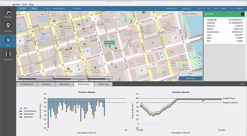
The Skydel Real-Time Performance graphs illustrate the software-defined engine’s low latency during a GNSS simulation. (Screenshot: Orolia)
Orolia has announced the launch of its Real-Time Performance capability, which achieves an ultra-low latency of five milliseconds. The feature will be standard on all Skydel-powered GNSS simulators.
Skydel is a software-defined simulation engine that powers Orolia’s advanced GNSS simulators including its BroadSim (available via Orolia Defense & Security) and GSG product lines.
“Skydel is known by users for its intuitive nature and ability to be quickly redeployed for a variety of projects,” said Tim Erbes, director of engineering for Orolia Defense & Security. “Delivering Real-Time Performance with latency as low as five milliseconds further shows that Orolia is a market leader empowering our customers by exceeding their expectations.”
Skydel’s software-defined architecture is designed to meet the demanding GNSS simulation testing requirements in the automotive, military, space and other high-tech industries. Skydel also supports hardware-in-the-loop simulations without sacrificing ultra-low latency and high-end performance.
The user interface has a sophisticated dashboard showing Real-Time Performance graphs. The tool enables users to grade the simulator’s performance, interpret data, diagnose inefficiencies, and optimize scenarios on the fly. In a video tutorial, Orolia demonstrates how the simulation engine processes data and how easy it is to read the graphs through its visualization and precise indications. As the system reaches its limits, it remains stable and fully operational, preserving the integrity of the simulation.
Erbes said the Real-Time Performance graphs not only instill confidence in the simulator, but also allow for better integration in the testbed.
“For example, instead of just hoping their hardware-in-the-loop configuration is working, users can view the real-time data and see that low latency is being maintained,” he said. “This feature provides enhanced visibility not only into the performance of the simulation, but also into the reliability of the hardware-in-the-loop integration, resulting in a more robust solution. This is critical when generating complex environments with high dynamics, jamming, spoofing, repeating, and alternative PNT sensors.”
Microchip Technology has integrate its BlueSky technology signal-anomaly detection software into its SyncServer S600 Series network time server and instruments.
The SyncServer S600 Series now provides GPS jamming and spoofing detection and protection, in combination with local radio frequency (RF) data logging and analysis. The SyncServer S600 Series Stratum 1 instrument, along with the BlueSky technology’s intelligent jamming and spoofing detectors, continuously monitor local GPS constellation health and examine GPS and local RF signal integrity to assure validity.
If an anomaly is detected, the solution sends an alarm and, if necessary, the SyncServer instrument can be shifted to alternative time sources or an internal oscillator. This protects ongoing timing outputs while ensuring only minimal, predictable timing degradation to vital network and business operations in applications ranging from banking and stock trading to electric utilities and aerospace and defense.
The SyncServer BlueSky technology, which provides continuous detection and protection against GPS jamming and spoofing. includes a comprehensive suite of logging, charting and measuring tools to characterize local GPS satellite signals as well as local RF events over time.
This can help enable correlating, troubleshooting, identifying and correcting local anomalies, some of which may be related to consumer electronics, or nearby RF signal broadcasts. The solution is optionally available through the SyncServer v4.1 software release that provides a selection of features found in Microchip’s BlueSky GNSS Firewall solution for third-party GPS receivers and critical infrastructure.
To mark the one-year anniversary of the PNT Executive Order, Orolia will host an interactive Coffee Talk webinar on March 24 to explore the latest developments in the national initiative to protect U.S. critical infrastructure from GPS/GNSS jamming, spoofing and interference.
Panelists from the U.S. Department of Homeland Security (DHS) and the National Institute of Standards and Technology (NIST), among others, will focus on key actions and priorities for 2021 and beyond, including insights and context on recently published works such as the NIST Foundational PNT Profile issued on Feb. 11, 2021, and the DHS Conformance Framework of Dec. 18, 2020.
Critical infrastructure and PNT industry panelists will also share their perspectives on practical ways to increase resiliency and key factors to consider, in view of the latest Executive Order guidance.
More information about Resilient PNT and GNSS jamming/spoofing is available in Orolia’s online resource center.
Panelists include:
Ernest Wong, Technical Manager, Science and Technology Directorate, DHS
Jim McCarthy, Senior Security Engineer, National CyberSecurity Center of Excellence, NIST
Register here for the Coffee Talk “PNT Executive Order Update: 2021 Actions and Priorities,” 11 a.m. EDT, March 24. Use the registration form to share questions or comments on what to discuss.
NovAtel’s GPS Anti-Jam Technology (GAJT) product lines achieved a milestone of thousands of units shipped worldwide in 2020. Despite COVID-19, 2020 has proven to be one of NovAtel’s most successful years in protecting positioning, navigation and timing (PNT) from cyber electromagnetic activities (CEMA) for military and civil organizations, the company stated in a press release.
Jamming and interference are growing threats, from a crowded RF spectrum to malicious jamming attempts. However, the GNSS market is responding with anti-jam technologies. Across the world — on land, in the air and at sea — NovAtel customers use GAJT to protect their GNSS navigation and precise timing receivers from intentional jamming and unintentional interference.
The GAJT portfolio includes commercial off-the-shelf solutions with short order lead times for rapid deployment. The range of products can be readily integrated into new platforms or retrofitted into legacy fleets.
Photo: Hexagon | NovAtel
The GAJT-710, its smaller counterpart GAJT-410 and the GAJT-AE variants are used worldwide to protect PNT against jamming and interference no matter the environment.
Beyond defense, GAJT enables users to be proactive against cyber electromagnetic activities using situation awareness technology to indicate the presence and direction of jamming signals.
“Jamming and interference are growing threats worldwide. GAJT protects our customers no matter where they operate,” said Steve Duncombe, executive VP of Aerospace and Defense at NovAtel. “We’re proud to achieve this milestone during a challenging 2020 and will continue delivering assured positioning in our customers’ critical applications with extremely short delivery times.”
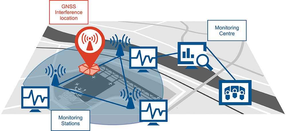
Schematic of the GNSS interference detection and analysis system GIDAS. (Image: OHB Digital Solutions)
In September 2020, the first GIDAS monitoring stations were installed at the Czech airport in Brno.
GIDAS — GNSS Interference Detection and Analysis System — enables continuous 24/7 monitoring of the GNSS frequency bands within a defined region to automatically detect, classify and localize intentional interference from jamming and spoofing.
GIDAS can raise the alarm in real time, identify the type of interference, and then pinpoint the location of these dangerous portable devices causing the interference so the authorities can take immediate remedial action. It considerably improves safe and robust operation of GNSS receivers, terminals and applications.
GIDAS was developed by OHB Digital Solutions and Joanneum University of Applied Sciences through ESA’s Navigation Innovation and Support Programme (NAVISP).
The system works autonomously and is designed to be easily deployed. It is scalable and flexible; it can be used as a standalone monitoring station or upgraded to a network of stations.
Recent GNSS interference attacks include:
shutdown of navigation equipment at Newark airport
GNSS attacks of North Korea against South Korea
117 incidents within one day at Kaohsiung airport in Taiwan
a U.S. military drone forced to land
a 65-meter yacht drifting off course during field trials
failure of emergency pagers, traffic management systems and ATMs in San Diego caused by U.S. Navy jamming.
“In recent years, GNSS applications have increasingly become the target of intentional interference attacks, since GNSS is widely used in safety and value-critical applications,” said Andreas Lesch, CEO of OHB Digital Solutions. “GIDAS detects, classifies and localizes GNSS interference signals and thus reduces the already existing threat of receiving worse accuracies or even denial of service.”
The GIDAS system user interface helps to pinpoint interference. (Image: OHB Digital Solutions)
GIDAS monitors the GNSS L1/E1 frequency band and reliably detects and classifies intentional and unintentional interference sources using sophisticated algorithms. GIDAS consists of a high performance data processing unit including antenna and RF front-end, and a sophisticated software solution.
GIDAS is able not only to monitor GNSS-based position, velocity and time solutions, it monitors the received signal and baseband processing.
The system is composed of the following software modules:
Software-defined GNSS radio
Position, baseband and C/N0 monitoring
Jammer and spoofing parameter estimation
Localization capabilities through synchronization of several GIDAS systems
Graphical user interface
Initial GIDAS reports show an average of seven GNSS interference events per day. GIDAS was able to successfully classify the signal type in 96% of jamming cases that have occurred.
Senate poised to join House this week and override Trump’s veto
The U. S. Congress, especially the Armed Services Committees, have long been concerned about GPS and positioning, navigation, and timing (PNT) issues. Over the last two decades Congressional hearings, demands for reports, and investigations have dealt with acquisition, contingency plans for when space is not available, deliberate interference, and a host of other issues.
While these all evidenced Congress’ interest and concern, they were relatively passive measures.
The NDAA for 2021 seems to finalize Congress’ transition from an interested observer, mostly on the sidelines, to an active player in national PNT issues and policy.
This began to change in 2018 with passage of the National Timing Resilience and Security Act. It requires the Department of Transportation to establish a terrestrial timing system to backup GPS signals.
Then in 2019, Congress appropriated money for a GPS Backup Technology Demonstration. And the National Defense Authorization Act (NDAA) for 2020 required the Air Force to develop a prototype multi-GNSS receiver as part of its resiliency efforts.
The NDAA for 2021 seems to finalize Congress’ transition from an interested observer, mostly on the sidelines, to an active player in national PNT issues and policy.
Capitol Hill observers say this is the result of several things that have come to a head over the last year. Taken together, they have convinced many legislators that GPS is under threat and PNT issues are not being taken seriously enough by the executive branch. These include increased jamming and spoofing (especially by China and Russia), full implementation of China’s BeiDou system and its marketing to other nations as a superior alternative to GPS, the Federal Communications Commission’s (FCC) decision on Ligado Networks, and the Pentagon’s failure to respond to combatant commanders’ Joint Urgent Operational Needs Statements for non-GPS PNT.
Photo: Andrea Izzotti/Shutterstock.com
Here are some of the provisions of the 2021 NDAA of interest to the PNT community.
Military Multi-GNSS Receiver Prototype
The 2018 NDAA required the Defense Department to incorporate Europe’s Galileo and Japan’s QZSS satellite navigation signals into military user equipment. The idea was to make it more resilient to disruption. Also required was an investigation into using non-allied signals.
Apparently not satisfied with progress on this project, Congress mandated a project to develop a prototype multi-GNSS receiver as part of the 2020 NDAA.
The 2021 NDAA seems to indicate the Congress is still not happy. It withholds 20% of the funding for the Office of the Secretary of the Air Force until such time as the department certifies the prototype project is underway and provides briefings to the Senate and House Armed Services Committees.
Resilient Survivable PNT
Language in the 2021 NDAA also seems to show Congress is impatient with the Pentagon’s lack of responsiveness to combatant commanders’ requests for non-GPS PNT systems.
Section 1611 of the Act is entitled “Resilient and Survivable Positioning, Navigation, and Timing Capabilities.” It requires development, integration, and deployment of these capabilities for combatant commanders within two years. This, it says, is “… consistent with the timescale applicable to joint urgent operational needs statements…”
The act says the new PNT capabilities shall “generate resilient and survivable alternative positioning, navigation, and timing signals” and “process resilient survivable data provided by signals of opportunity and on-board sensor systems.”
The act also reverses the Defense Department’s 2018 PNT Strategy’s plan for future systems to be classified and for military use only. It directs the department to work with the National Security Council, Departments of Transportation, Homeland Security and others “to enable civilian and commercial adoption of technologies and capabilities for resilient and survivable alternative positioning, navigation, and timing capabilities to complement the global positioning system.”
To help ensure prompt action on this, the act requires a report to Congress within six months and authorizes the department to reprogram funds from other areas to finance the effort.
Responding to FCC’s Decision on Ligado Networks
By far the most PNT-related text in the 2021 NDAA includes a host of measures responding to FCC Order 20-48 approving an application by Ligado Networks. An order which the executive branch is on record as strongly opposing saying it will degrade GPS service for many.
Senator Jim Inhofe, chair of the Senate Armed Services Committee, has regularly expressed outrage at the FCC’s decision and has called for its reversal.
Among its provisions the act:
Requires the Department of Defense to estimate and report to Congress the cost of damage to department systems as a result of the FCC order.
Prohibits using department funds to upgrade or modify military equipment to make it resilient to interference caused by broadcasts in the spectrum allocated (the FCC order requires this to be funded by Ligado)
Prohibits contracting with any entity using the frequency bands allocated to Ligado unless the Secretary of Defense certifies the use will not interfere with GPS services
Requires the Secretary of Defense to contract with the National Academies of Sciences, Engineering, and Medicine for an independent technical review of the FCC order.
Speakers include Diana Furchtgott-Roth Deputy Assistant Secretary for Research and Technology; ship captains from Maersk Lines; and representatives from the National Security Council, the Maritime Administration and U.S. Coast Guard.
While GPS jamming and spoofing is a problem in many transportation and critical infrastructure sectors, it is often most visible in maritime. This is because the Automatic Identification System (AIS) used for collision avoidance and traffic management for major vessels transmits location data based on GPS inputs.
These transmissions are received by coastal networks and satellite systems. AIS data is often freely available to the public or easily accessed.
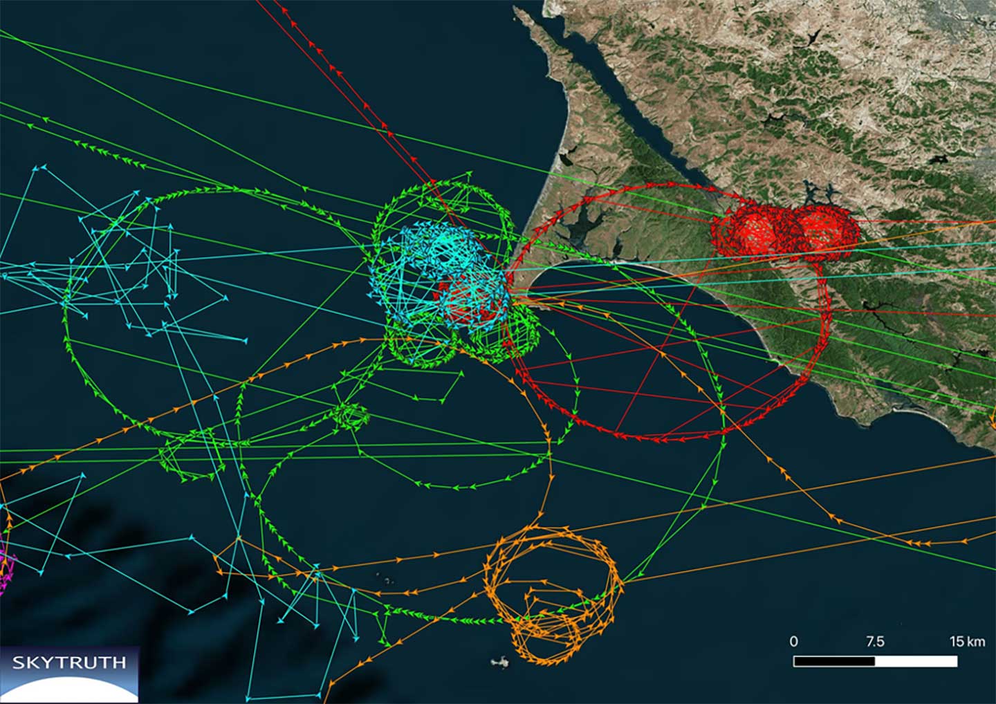
Ships in Russian waters being spoofed to inland airports, vessels in Chinese ports reporting they are inland and circling government buildings, and ships in one part of the world transmitting their location as thousands of miles away and circling in the ocean off northern California are three of the highest provide examples in recent years.
In 2019, the U.S. Coast Guard brought interference with GPS signals as an “urgent issue” to the International Maritime Organization.
In February, President Trump issued an Executive Order on responsible use of positioning, navigation and timing. This workshop is part of the federal government’s efforts, as a part of the order, to educate the public about vulnerabilities associated with over-reliance on GPA.
The full GNSS User Technology Report 2020 is available for download. (Cover: GSA)
News from the European GNSS Agency
The European GNSS Agency (GSA) has released its latest GNSS User Technology Report, providing a comprehensive analysis of GNSS trends and developments.
With four GNSS available and more than 100 satellites in operation broadcasting multiple frequencies, the GNSS industry is shifting towards the wide adoption of multifrequency receivers across market segments to meet the diverging user needs of emerging applications.
The report includes contributions from leading GNSS receiver, chipset manufacturers and service providers, and serves as a valuable tool to support planning and decision-making with regards to developing, purchasing and using GNSS technology.
Published biennially since 2016, the User Technology Report has become a point of reference for the GNSS industry, research and policy-makers.
Rapid Evolution
‘’The GNSS industry is evolving at a rapid pace and is shaped by the dynamics of emerging applications and user needs as well as the upgrade of existing and new GNSS and Satellite Based Augmentation Systems (SBAS),” said Rodrigo da Costa, GSA executive director. “The industry has understood the potential of Galileo’s unique features.”
The third edition of the report begins with a chapter devoted to technology trends common to all segments: receiver design, position processing and signal processing. It also discusses protection measures against GNSS jamming and spoofing, such as authentication, including what 5G and other technologies and sensors can do, in combination with GNSS.
With multi-constellation now being the norm, the industry is moving towards the wide adoption of multi-frequency receivers even for usually power- and cost-constrained consumer solutions. The Galileo E5 is becoming the preferred frequency with about 20% of all receiver models in the market already using it.
The report is built around four macro segments defined on the basis of commonalities from a technology point of view:
high volume
safety- and liability-critical
high-accuracy
timing devices and solutions (a new-entry in this edition)
Each chapter starts with the macrosegment characteristics and receiver capabilities, depicts the industry landscape and typical receiver form factor, it then delves into the key current and future drivers and trends, and finishes with the added value of the EGNSS, Galileo and EGNOS, for the macrosegment at stake.
Space Data for Europe
This year editor’s special “Space Data for Europe” sheds light on the role that Copernicus and Galileo play within the European Space Programme in the data management and use, now and in the future. It also provides a vision of major transformations underway within our society and our economy and the benefits expected from this digital transformation, paving the way towards the European Data Strategy and Green Deal.
“Today, Galileo and EGNOS already provide increased capabilities which are being used across a broad range of applications, and are already igniting the next generation of location-based applications. In the future, new services — the Galileo High Accuracy Service (HAS), Galileo Open Service Navigation Message Authentication (OS-NMA) and Commercial Augmentation Service (CAS) — will raise the accuracy and reliability bar even higher, and dramatically enhance positioning, navigation and timing solutions for businesses and citizens.
By bringing insight and understanding into the evolutions of GNSS technology, we are creating opportunities for innovation,” concluded da Costa.
The U.S. Army is opening a new office and laboratory to develop agile position, navigation and timing solutions to reduce soldiers’ dependence on GPS, according to reports in C4ISRNET and Defense News.
The new PNT modernization product office will focus on developing and deploying solutions that keep soldiers operating in areas where the GPS signal has been denied, degraded or spoofed. The office will open Oct. 8, and will use an open-systems architecture.
The new office will also host an Open Innovation Lab, a space where commercial entities can work with the Army to develop PNT solutions. Within lab, the Army has set aside space for the CMOSS (C4ISR/EW Modular Open Suite of Standards) Lab and the Network Cross-Functional Team’s Orion Forge at Aberdeen Proving Ground in Maryland.
The lab will be physically separated from the more classified areas of the site to encourage engagement with industry. Technologies to be explored include radio frequency systems, GPS, alt-nav, chip-scale atomic clocks, other timing technologies and celestial navigation.
According to the reports, the technologies will be fielded fast, with new solutions every five years. This is in contrast to the usual method of a decade spent developing technologies meant to last 20 years so that soldiers can always combat adversaries’ capabilities.
Andradige Silva, electronics engineer for the C5ISR Center’s Intelligence and Information Warfare Directorate, and Maj. Doug Williams, assistant product manager for the Joint Battle Command-Platform, access the C4ISR/Electronic Warfare Modular Open Suite of Standards (CMOSS). (Photo: U.S. Army)
A GNSS jamming trial will take place from Sept. 8 through Dec. 4 in and around Luce Bay, at Wigtownshire in southern Scotland, conducted by the United Kingdom’s Civil Aviation Authority.
The trial will affect electronic situational awareness devices, UAS command systems and GNSS receivers.
The activity may affect GNSS receivers along with UAS and cockpit devices operating on 433, 868, 915, 2400, 5800 MHz operating up to 40,000FT AMSL within 55NM of 545020N 045548W (West Freugh).
During the trials, impacted systems may suffer intermittent or total failure. Individual events will not exceed two minutes in duration with no more than five events per hour. Activity will take place in the daytime hours between 0830 and 1600.
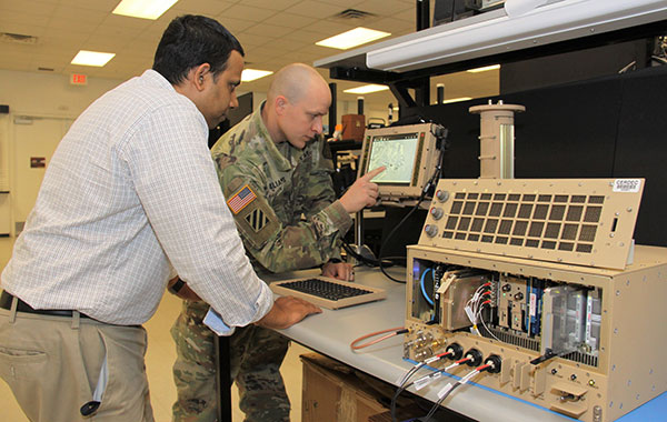
Spirent Federal Systems has been awarded a contract to support anechoic chamber testing for a major U.S. military agency.
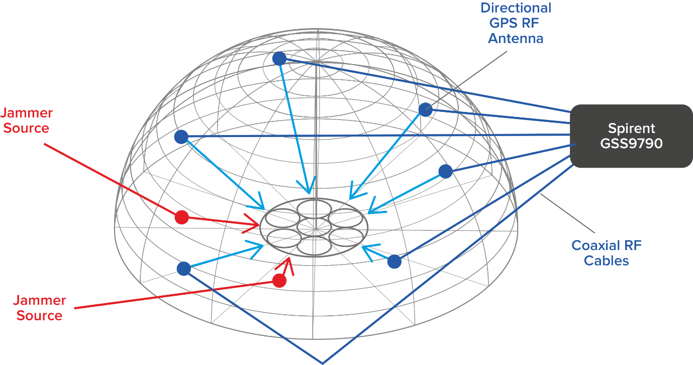
Spirent’s GSS9790 multi-output, multi-GNSS RF constellation wave-front simulator will be used as the signal generator attached to multiple transmission antennas for broadcast into the chambers.
Within this design, the antennas are structurally distributed to represent the correct arrival vectors of the simulated satellite signals on the device under test, creating the most realistic test environment possible. In addition, the GSS9790 supports interference sources located anywhere in the chamber to imitate different threat scenarios.
Image: Spirent
“Interference can threaten GNSS signals in multiple ways,” explained Jeff Martin, VP Sales. “We recognize the need for controlled, repeatable conditions to combat these threats. The GSS9790 delivers all the tools needed to successfully mitigate them.”
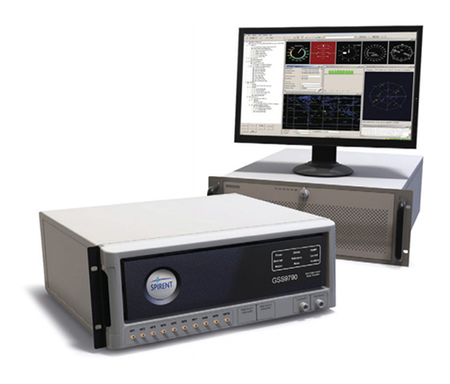
The GSS9790 simulator. (Photo: Spirent)
The Spirent GSS9790 supports classified Y-code, SAASM and M-code and can be found in key government labs across the country.
The Spirent GSS9790 enables verification of CRPA systems, spatial testing of single-antenna devices, and real-world-time-synchronized indoor GNSS implementations. The system is a development of the Spirent GSS9000. Combined with Spirent’s SimGEN software, it offers a powerful test platform for anti-jam and interference testing.
An international survey and analysis on GNSS interference detection and localization systems reveal the path forward for transportation and other critical infrastructure.
By José Luis Madrid-Cobos and Ana Bodero-Alonso, ENAIRE
Ignacio Fernández-Hernández and Eric Châtre, EC
Andriy Konovaltsev, DLR, and Christopher Hegarty, MITRE
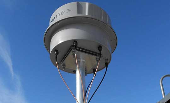
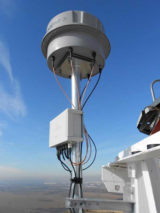
An ENAIRE GNSS RFI monitor close to the Madrid-Barajas Airport in Madrid, Spain. (Photo: ENAIRE)
The received power of GPS and Galileo navigation signals at the antenna output of a user receiver is typically extremely small, from approximately –165 up to –150 dBW, which makes them inherently vulnerable to radio-frequency interference (RFI) caused by the emissions of other radio systems. This interference is often unintentional, such as from malfunctioning or spurious emission from a transmitter in the vicinity of the GNSS receiver.
However, we have seen numerous reports about the deliberate jamming of GNSS signals. The most frequent examples of such interference reports are caused by so-called personal privacy devices (PPDs) — low-power GNSS jammers used to locally disable the operation of GNSS receivers. Although the use of PPDs is illegal, they can be easily acquired on the internet. A $10 jammer with 100 mW of transmitter power is enough to degrade performance or disrupt GNSS receivers in a range of 10–100 meters. In the past decade, more complex and powerful jammers have also become available, along with spoofers — devices that create GNSS-like signals that fool receivers to provide false location or time solutions. A $100 software-defined radio bought online can be used as a spoofer.
ENAIRE (the Spanish air navigation service provider) conducted an international survey and associated analysis of GNSS RFI detection and localization systems. The survey was part of the EU–U.S. Working Group C Sept. 2017–Sept. 2019 Work Plan, with contributions of the European Commission (DG DEFIS), the German Aerospace Center (DLR), the U.S. Federal Aviation Administration (FAA), Eurocontrol, the MITRE Corporation and Stanford University. Working Group C promotes cooperation between the U.S. and EU on design and development of the next generation of civil satellite-based navigation and timing systems. The survey was conducted within the Resilience Subgroup focused on counteractions required in view of growing concerns over jamming and spoofing threats.
Manufacturers and Users
The survey was provided in two versions: one targeted to manufacturers and another to the users of interference detection systems. The two surveys were implemented online July 12–Oct. 26, 2018. There were 23 responses: 11 from manufacturers and 12 from users (see Acknowledgments below for companies that participated). Regarding the manufacturers’ responses, the nine surveyed companies represent about 50% of the market of RFI monitoring products available in 2018.
RFI Equipment Used
We present here the aggregated results of the RFI equipment manufactured and used by the participating entities.
Frequency Bands and Signals. The L1/E1 band is covered by all of the manufacturers’ and users’ surveyed products. L5/E5a and other bands are monitored in only 42% of the cases, or even less. Most RFI systems demodulate or analyze the GPS L1 C/A signal. Only 8% and 17% of users analyze GPS L5 and Galileo E5a, respectively.
Capabilities. 55% of the industry, and 25% of the users’ surveyed products, provide RFI localization capabilities, while 45% of the industry, and only 33% of the users’ surveyed products, detect some type of spoofing.
Power and Antenna Gain. Most of the systems achieve a sensitivity better than or equal to –120 dBm, meeting the International Civil Aviation Organization requirement for GPS and SBAS L1 airborne receivers to withstand interference (–120.5 dBm CW, in-band) after steady-state navigation has been established. The gain of antennas used in RFI detection systems ranges from 2 dBi up to 45 dBi.
Real-Time Bandwidth. The maximum real-time monitored bandwidth of the surveyed products ranges from 16 MHz up to 60 MHz in L1. Most of the products monitor a 20-MHz bandwidth (similar to the GPS L1 C/A reference bandwidth for pre-GPS III satellites, which is 20.46 MHz).
Spectrum Refresh Time. The time needed by the RFI detector to capture and process a plot of the RF spectrum in a specific band to look for interference signals ranges from 1 microsecond to 2 seconds.
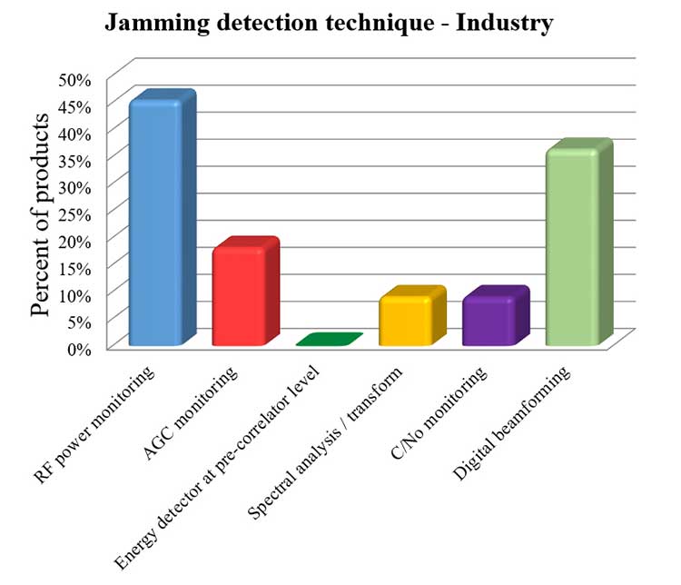
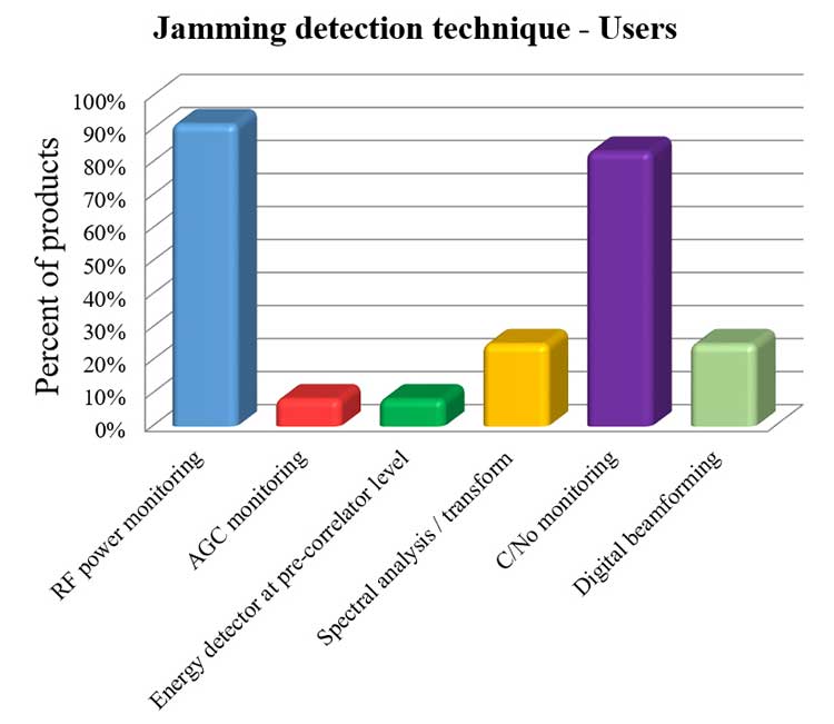
Jamming Detection Techniques. The most widespread jamming detection technique is RF power monitoring (45% industry, 92% users), followed by digital beamforming (CRPAs), carrier-to-noise-density ratio (C/N0) monitoring and spectral analysis/transforms (see Figure 1). Note that RF power monitoring and automatic gain control (AGC) monitoring are in essence the same detection technique: AGC voltage levels — after calibration with a reference RF generator — can be converted into RF input power levels.
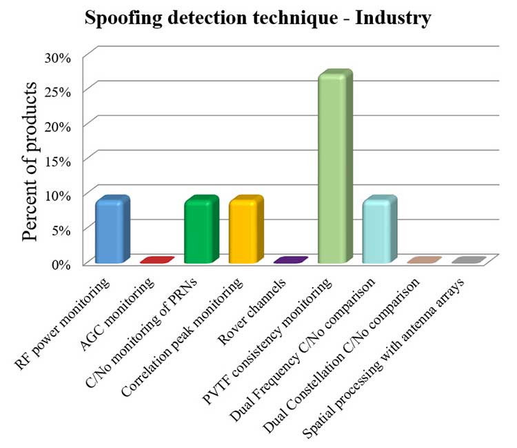
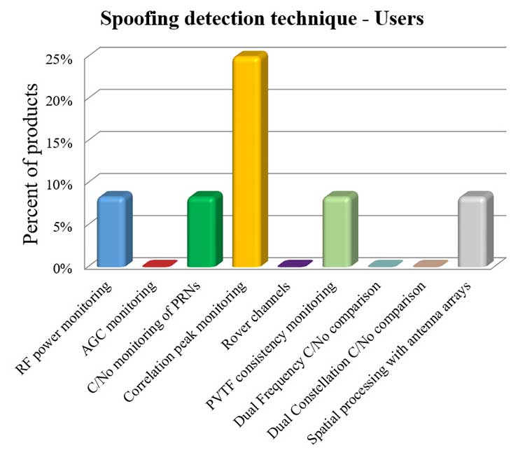
Figure 1a. Jamming detection techniques used by industry. (Chart: RFI survey)Figure 1b. Jamming detection techniques of users. (Chart: RFI survey)
Spoofing Detection Techniques. The most widespread spoofing detection techniques are PVTF consistency monitoring (industry products, 27%) and correlation peak monitoring (users, 25%), followed by digital beamforming (CRPAs), C/N0 monitoring and spectral analysis/transforms (see Figure 2).
Figure 2a. Spoofing detection techniques used by industry. (Chart: RFI survey)Figure 2b. Spoofing detection techniques of users.(Chart: RFI survey)
Localization. The most widespread RFI localization technique is direction/angle of arrival (DOA/AOA): 55% in industry products and 25% in users’ systems. AOA techniques used are correlative interferometer (phase-difference), Watson-Watt (amplitude-difference) and array signal processing. The AOA accuracy of surveyed products ranges from ±3° to ±10°.
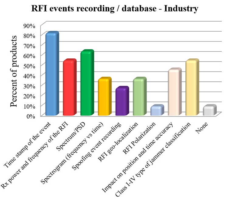
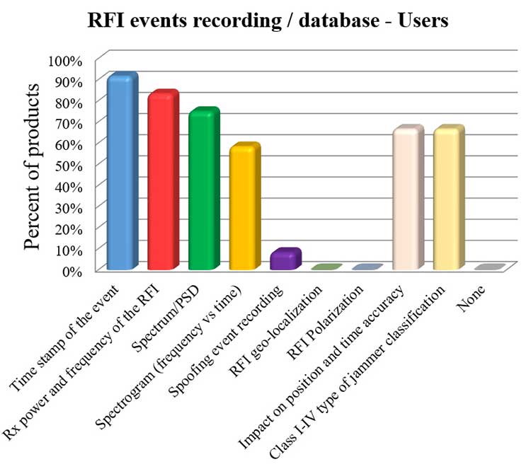
Event Recording. For an interference event, most products record the time stamp, received power, central frequency, frequency spectrum, the spectrogram (frequency versus time plot) and the jammer type. Only 8% of surveyed users perform spoofing event recording (see Figure 3). 92% of users record RFI/spoofing events; half also report them to their national spectrum administration. Users have from one to 11 jammer detectors. Only four users have been registered with spoofing detectors, each using one.
Figure 3a. RFI events recording/database used by industry. Jammer classifications: Class I — continuous wave signal; Class II — chirp signal with one saw-tooth function; Class III — chirp signal with multi saw-tooth functions; Class IV — chirp signal with frequency bursts. (Chart: RFI survey)Figure 3b. RFI events recording/database of users. Jammer classifications: Class I — continuous wave signal; Class II — chirp signal with one saw-tooth function; Class III — chirp signal with multi saw-tooth functions; Class IV — chirp signal with frequency bursts. (Chart: RFI survey)
Event Sharing. 75% of surveyed users are willing to collaborate in the creation of an international RFI and spoofing events common database, but the remaining 25% explicitly do not want to share their databases.
Future RFI Monitoring Equipment
Based on the analysis of the aggregated results from the survey, we identified some recommendations for improving RFI monitoring:
L5/E5a band. To be ready for introduction of the L5/E5a band into aviation operational use (expected by 2025), it is suggested that aviation organizations increase efforts to monitor and analyze the RFI situation in the L5/E5a band.
Spoofing detection. National organizations in charge of critical infrastructures should increase their efforts to detect spoofing (at least at the same level as jamming detection). Multi-constellation and dual-frequency spoofing detection should be promoted (not only L1/E1 spoofing).
GNSS RFI monitoring with enough bandwidth: The maximum real-time monitored bandwidth of the surveyed products ranges from 16 MHz to 60 MHz, while most of the products monitor only a 20-MHz bandwidth. The receiver reference bandwidth for E1 is 24.552 MHz, while for L1 GPS III it is 30.69 MHz. U.S.-EU GNSS RFI detection systems for critical infrastructures should be designed to monitor at least 31 MHz of bandwidth in the L1/E1 band, with 50 MHz recommended to cope with typical –3 dB bandwidth of pre-low-noise-amplifier (LNA) GNSS L1/E1 receiver filter. The same rule should be applied to other GNSS bands. Even more bandwidth for monitoring could be needed to cope with rare interferers, such as a high-power source, whether intentional or unintentional, radiating in near-band L1/E1 but not in the passband frequencies, bypassing the rejection of the receiver’s filters and degrading the GNSS signal reception.
Air Navigation
In the EU, performance-based navigation (PBN) will become the norm in all flight phases, and GNSS (with or without SBAS) will be the main position source, by June 2030. A similar scenario is being developed in the U.S. Conventional procedures and ground-based navigation aids will be used only in contingency situations. GNSS RFI can degrade the current GBAS CAT I (GAST-C) service in airports and could jeopardize safe operation of upcoming GBAS CAT II-III (GAST-D) service. GNSS also is the key enabler for ADS-B.
Therefore, it is critical for air transportation to improve its capability to detect radio frequency interference to GNSS and mitigate its harmful effects, both on the ground and in the air.
Ground Detection and Localization. These systems should be installed at and around all airports. ENAIRE has recently deployed an AOA RFI detection and localization system around the Madrid airport called DYLEMA. It consists of nine AOA RFI and spoofing detectors, two spoofing-only detectors, an IP communication network and a GNSS monitoring center operated 24/7. From this center, ENAIRE will report RFI events to the Spanish spectrum agency. Similar systems will be deployed in other large Spanish airports in the next years. In small airports, ENAIRE is deploying single-unit RFI detectors (one detector per airport, currently without the AOA feature). These systems are complemented by handheld and airborne spectrum analyzers equipped with directional antennas and RFI AOA features, used if an RFI event of high power or duration takes place.
Airborne Detection and Localization. Several initiatives are under study or initial design for airborne detection and localization systems, using current avionics receivers with no hardware modification or new hardware such as additional antennas in the aircraft. Future airborne RFI detection systems should include indoor coverage to detect jammers and spoofers in the airplane itself. EUROCONTROL is leading one of these initiatives using ADS-B. Given a reliable ADS-B data feed with suitable coverage information, a search algorithm could scan for outages. If the data is dense enough, it is possible to locate the source, even if the GNSS airborne antenna is omnidirectional with no AOA features. Another commercial initiative, GATEMAN, uses new GNSS antennas and components to provide AOA detection and localization features.
UAV-Embedded Detection and Localization. Detection and localization systems embedded in UAVs are not widely commercially available, but they will be useful to complement fixed or ground RFI monitoring systems, especially to detect fast moving mobile jammers and spoofers. A jammer moving at high speed could be found by a fixed detector, trigger the UAV take-off (collocated with the detector or close to it), and start tracking the target. If equipped with a camera, it could identify the vehicle carrying the jammer or spoofer. Such a system has to function in GNSS-denied scenarios, and needs to use sensors other than GNSS. Stanford University has recently developed a prototype of such a system.
Other Sectors
Shipping. RFI detection systems should be installed at and around harbors, where positioning requirements are the most stringent. Mobile AOA detectors can be installed in vessels. A DLR experiment integrated its GALANT GNSS RFI detector on a ship sailing from Spain to South Korea and back.
Railroads. Detection and localization systems should be installed at train stations and main railway junctions or switches. It is possible to install mobile detectors in trains to detect jammers inside the train apart from outdoor coverage to detect jammers outside the train.
Roads. Most PPD jammers in use are on roadways. Jammers not only jeopardize aviation and timing systems; they can jeopardize the safety of the coming autonomous road vehicles. We strongly recommend that police and road surveillance systems include jammers and spoofers as a daily target, to detect, localize and punish their users.
Supporting proposals include installing fixed detectors at tollbooths, road gantries or other points near roads; and using mobile detectors — for example, on police vehicles for locating a car that carries a jammer. Public transport services with enough vehicles (such as taxis or busses) could also detect RFI.
Smartphone Platforms. Initiatives are using smartphone crowdsourcing platforms to detect interference based on C/N0 or AGC measurements. At this time, only prototype apps for Android phones are available. The Apple iOS does not allow access to GNSS raw data. Android applications can include localization capabilities based on Time Difference Of Arrival (TDOA) or Power Difference Of Arrival (PDOA). Having a detection system in a mass-market product would create millions of detectors around the world. Reward programs by national or local administrations would encourage use of the app. User consent to obtain the data will be needed.
Space-Based Detection. Space-based detection is feasible to find medium- to high-power jammers and spoofers. Several projects have performed simulations, such as the ground to space threat simulator from Qascom and Spirent Communications. In this project, simulations achieved an error of less than 1.5 km using a medium-Earth-orbit (MEO) satellite as the RFI sensor and a 20-dBm static jammer on Earth, with 15 minutes of observation time. Also, an experimental program from the International Space Station has demonstrated that RFI can be detected from low Earth orbit.
The main issue of such detection systems is the cost to deploy all the satellites needed to have a global coverage with a low response time (2 hours or less to detect RFI). The performance of a space-based RFI system is better when using a LEO constellation (as, compared to an MEO system, it detects RFI with a lower transmitted power). One such system by HawkEye 360 was deployed in 2019. The company plans to operate a fleet of 30 satellites in LEO orbit, enabling it to gather new signals from any point on the planet within 30 to 45 minutes.
General Recommendations
Increased Effort Needed. Public administrations and transport service providers should increase their efforts to deploy GNSS RFI detection and localization systems. In parallel, governments should punish individuals or organizations using jammers or other types of illegal transmitters or emissions. Jamming and spoofing is illegal in the EU and the U.S. An increased RFI monitoring effort should be coordinated at the national or regional level to find synergies and avoid duplications.
Planned Interference. Government agencies, including national radiofrequency spectrum agencies, should coordinate nationally and internationally with air, rail, road, maritime and other critical infrastructure entities before any planned intentional interference is conducted, such as military exercises or protection of special events from potential terrorist attack. This coordination includes an analysis of the estimated area and airspace volume affected by the RFI, the associated notification to the GNSS users before and during the RFI radiation period (such as a NOTAM, Notice to Airmen), as well as the indication to use established alternative procedures (non-GNSS).
A Common Database. The creation of an international common database of GNSS RFI events could boost the fight against GNSS RFI. A specific action could define a standard of the RFI data format to be registered and shared in an international database, including a possible RFI classification (also defined and agreed to as part of the standard). One initiative related to the creation of an international GNSS RFI threats database was proposed by the EU-funded STRIKE 3 project in 2017.
Acknowledgments
The work presented in this report has been performed under the U.S.-EU Agreement on GPS-Galileo Cooperation, Working Group C, Resiliency Subgroup. The authors thank the participants of the Working Group and the Resiliency Subgroup — in particular, Eurocontrol and the FAA for distribution of the survey in the EU and the U.S., respectively. The authors also thank the organizations that participated in the survey: Spirent Communications, GMV, Centum Solutions, THALES, IDS AirNav, Chronos Technology, Innovationszentrum für Telekommunikationstechnik (IZT), Collins Aerospace, German Aerospace Center (DLR), Netherlands Aerospace Centre (NLR), Deutsche Flugsicherung (DFS), Direction des Services de la Navigation Aérienne (DSNA), Polish Air Navigation Services Agency (PANSA), Belgocontrol, ENAV and ENAIRE.
José Luis Madrid-Cobos is the technical manager of GNSS interference detection and localization systems at ENAIRE, the Air Navigation Service Provider in Spain. Ana Bodero-Alonso is the head of the Satellite Navigation Department at ENAIRE. Ignacio Fernández-Hernández is responsible for Galileo high accuracy and authentication at the European Commission. Eric Châtre is the head of the GNSS Exploitation and Evolutions Sector at the European Commission. Andriy Konovaltsev is a research assistant at Institute of Communications and Navigation of the German Aerospace Center (DLR). Christopher Hegarty is a technical fellow with The MITRE Corporation.