Tag: jamming

  • 13 EU member states demand action on GNSS interference

    13 EU member states demand action on GNSS interference

    13 member states of the European Union have called on the European Commission to respond to interference with GNSS in EU countries.

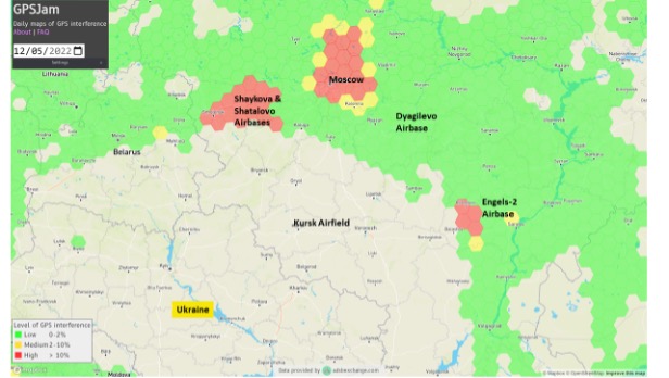
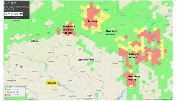
    The interference originates in Russia and Belarus, as a result of the ongoing war with Ukraine.

    The ministers for transport from 13 countries urged immediate and coordinated action in response, reports the Baltic Times. The joint letter was signed by the ministers of Lithuania, Latvia, Estonia, Germany, Slovakia, Finland, Slovenia, the Czech Republic, Italy, the Netherlands, Spain, Denmark and Romania.

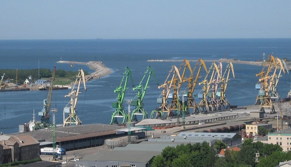
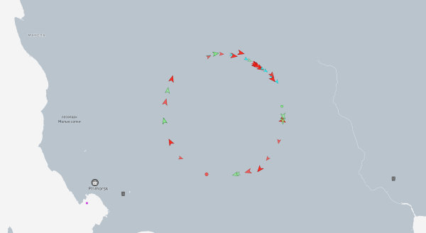
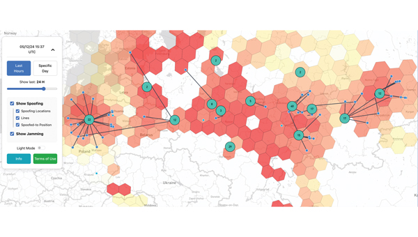
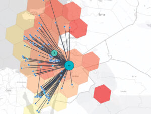
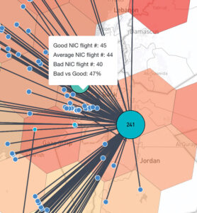
    In the joint letter, the ministers emphasize that since 2022, two types of interference to GNSS — jamming and spoofing — have been observed in the airspace of the Baltic Sea Region, posing a threat to various modes of transport, particularly civil aviation and maritime navigation.

    The General Secretariat of the Council of the EU responded to the joint letter with an outline of potential actions.

    1. Evaluate and coordinate the possibility to suspend the right to Russia and Belarus in the ITU to register the use of radio resources while GNSS interference is in progress. The lack of procedural legislation cannot be an excuse for deliberately contravening the spirit of the ITU Constitution and its general principles, endangering public health and life, without suffering any consequences.
    2. Based on good practice of EU and NATO cooperation on critical undersea infrastructure, enhance civil-military coordination mechanisms among Member States for shared monitoring, data exchange, and possible response to GNSS interference. Explore the benefits of dual use of various equipment and measures to combat the risks caused by GNSS interference.
    3. Intensify RFI monitoring by eligible national organizations and bodies, e. g. national regulator, police and military, and aggregate non-classified information on observed RFI to a publicly available near real-time monitoring and alert service on European level.
    4. Accelerate the deployment of interference resistant GNSS services, especially the antispoofing features that are part of the Galileo program, e. g. authentication and/or encryption of signals exchanged between stations and user equipment.
    5. Reassess the current reliance on GNSS-based navigation and develop resilient Positioning, Navigation and Timing (PST) services by deploying alternative or complementary systems, including ground-based legacy solutions. Simultaneously, upgrade and modernize conventional navigation infrastructures to serve as robust backups.
    6. Promote industry-manufacturer collaboration for mitigation tools and updates. Support operator-level reviews of backup system readiness, ensuring non-GNSS alternatives are usable and practiced. 2 TREE2B 9198/25 EN
    7. Draw the attention of critical infrastructure operators and unmanned system manufacturers to the risks that may arise from interference with GNSS.
    8. Develop action plans for different domains (space, aviation, maritime, telecommunications) to avoid potential duplication of efforts and coordinate short-term and long-term measures at EU and national level.
    9. Continue cooperation with all relevant stakeholders (ITU, ICAO, IMO, EASA, EMSA, IATA, EUROCONTROL). These actions, among others, could contribute to building the overall resilience of the critical infrastructure and strengthening safety and security in Europe.

    The letter highlights the urgent need to accelerate the deployment of interference-resistant GNSS services, enhance the overall resilience of critical infrastructure, and strengthen safety and security across Europe.

    “The current security environment demands a unified response to hybrid threats posed by hostile regimes, as well as close cooperation to strengthen Europe’s preparedness and resilience,” said Lithuanian Transport and Communications Minister Eugenijus Sabutis.

    “Disruptions to GNSS signals have a direct impact on strategic sectors such as transport, energy, and telecommunications. To prevent potential incidents, we must act swiftly and decisively at the European Union level — not individually, but in a coordinated manner,” Sabutis said.

    The interference is not random incidents but a systematic, deliberate action by Russia and Belarus, which can be used as a hybrid attack on strategic radio spectrum, essential for modern technology, regional safety and security, particularly in transportation.

    Furthermore, the ministers call on the EU to increase diplomatic efforts to address the interference and apply pressure on the responsible parties, including legal action against responsible individuals and entities involved in the deliberate interference with GNSS signals, to enhance European safety and security.

    “So far, the attempts by several Member States to address the problem have not brought any more tangible results,” the EU General Secretariats said. “Therefore, it is necessary to increase diplomatic efforts to address the interference and put the pressure on the responsible parties.”

    The ministers propose intensifying radio frequency monitoring and enhance civil-military coordination mechanisms among Member States for shared monitoring, data exchange and possible response to GNSS interference. They also advocate for accelerating the deployment of interference-resistant GNSS services, particularly the anti-spoofing features of the Galileo program, and for upgrading and modernizing conventional navigation infrastructure.

    Reports of increased interference include:

    • Lithuania: starting from 556 cases in March 2024 to 890 in October 2024 and 1185 in January 2025
    • Latvia: 790 cases in October 2024 to 1288 cases in January 2025
    • Estonia: 1150 cases in October 2024 and 1085 cases in January 2025
    • Poland: 1908 cases in October 2024 to 2732 cases in January 2025.

  • Lithuanian port hit by GNSS interference

    Lithuanian port hit by GNSS interference

    Russia’s war with Ukraine continues to affect GNSS signal availability in the Baltic Sea, reports LRT News. Aircraft and ships near the Lithuanian seaport of Klaipėda are losing signals becausse of Russia’s efforts to shield its Kaliningrad exclave from potential airstrikes, said Saulius Skvernelis, speaker of the Lithuanian parliament.

    “The Russians are protecting the Kaliningrad region from potential air attacks,” Skvernelis told LRT TV. “This is not specifically intended to disrupt or harm our aircraft flying to Lithuania. It’s just that the protection zone extends beyond the Kaliningrad region’s borders, and the threat, the interference, is affecting our territory as well.”

    Skvernelis warned that this problem will persist across the region as long as the Kremlin continues its war in Ukraine.

    Thirteen European Union member states have called on the European Commission to respond to interference with GNSS in EU countries. In a joint letter, the countries stressed that GNSS interference cases are not random incidents but systematic and deliberate action by the Russian and Belarusian regimes aimed at destabilizing regional infrastructure, especially in the transport sector, reports LRT.

    “We can appeal to all EU countries and any institution, but it won’t help as long as Russia uses this kind of electronic protection for its military sites to defend itself against Ukrainian strikes,” Skvernelis said. “We must force Russia to end the war and then this problem will simply go away.”

  • Russian jamming creates ‘Bermuda Triangle’ in Baltic

    Russian jamming creates ‘Bermuda Triangle’ in Baltic

    Russian jamming of GPS signals is suspected to be the cause behind a new “Bermuda Triangle” of navigation confusion in the eastern Baltic Sea.

    In the Gulf of Finland, ships are disappearing from radar and Russian fighter jets are traveling through NATO airspace, according to Danwatch, a Danish news outlet.

    Ship monitoring service MarineTraffic shows the position of ships in completely different places than their actual positions, currently on land east of coastal city Primorsk, Russia.

    Experts say that not only is GPS being disrupted, but hackers are also manipulating navigation data. They blame Russia for its hybrid activities and attacks, which it carries out both from its mainland territory and from the Kaliningrad enclave, located between Poland and Lithuania.

    Screenshot of MarineTraffic now shows boats traveling in a circle inland from the Baltic Sea.
    Screenshot of MarineTraffic taken June 4, 2025, shows ships traveling in a circle on land, well east of the Baltic Sea.

    Romania also has issues with Russian jamming and spoofing activities. The website Defense Romania quotes Gen. Gheorghiță Vlad, chief of the Romanian Defense Staff, who said jamming and spoofing has occurred on the Black Sea weekly since the start of Russia’s war with Ukraine. Also, Romanian defense forces have discovered 122 floating mines in the sea.

  • Ukraine’s Ruta missile to get EW-immune navigation system

    Ukraine’s Ruta missile to get EW-immune navigation system

    The Ruta OWA drone — actively used by Ukrainian forces for strikes at ranges up to 300 km — is being improved with a new visual navigation system, tested in combat conditions.

    The Ruta, manufactured by Destinus, is essentially a miniature cruise missile. It is often referred to as a “missile drone.” It will receive a new navigation system enabling high-precision strikes in GPS-denied contested environments, especially those from enemy electronic warfare (EW) countermeasures.

    The new navigation and guidance system will be provided by Spanish company UAV Navigation, part of Grupo Oesía, which entered an agreement with the Ukrainian Destinus on May 13.

    The agreement will focus on Ruta in its first phase. Ruta is the first low-cost missile (LCM) drone developed by Destinus designed to operate in highly contested scenarios. The system incorporates an advanced guidance, navigation and control system, developed by UAV Navigation-Grupo Oesía, which has been validated in real-world combat conditions, including GNSS-denied environments or under jamming and spoofing attacks.

    Ruta offers autonomous flight capabilities, target-referenced navigation, terminal optical guidance, and coordinated swarm operations, enabling the execution of complex synchronized attack maneuvers to saturate or deceive defense systems. The platform flies at a cruising speed of Mach 0.8, has a range of up to 500 km, and a terminal impact accuracy of 15 square meters.

  • Seen & Heard: Autonomous rides in LA, UAV show destroyed by jamming and more

    Seen & Heard: Autonomous rides in LA, UAV show destroyed by jamming and more

    “Seen & Heard” is a monthly feature of GPS World magazine, traveling the world to capture interesting and unusual news stories involving the GNSS/PNT industry.


    Waymo opens autonomous rides in LA

    Photo: Waymo
    Photo: Waymo

    Waymo has launched its fully autonomous ride-hailing service in Los Angeles, available 24/7, following a waitlist of nearly 300,000 users before its rollout. The service covers nearly 80 square miles of Los Angeles County, including Santa Monica, Hollywood Boulevard and the University of Southern California. Waymo plans to expand its coverage as it scales its operations.

    UAV show destroyed by jamming

    Photo: Chesky_W / iStock / Getty Images Plus / Getty Images
    Photo: Chesky_W / iStock / Getty Images Plus / Getty Images

    A large UAV show in Quanzhou, Fujian Province, China, ended in disaster when hundreds of UAVs crashed due to GNSS jamming. The event, intended to celebrate the city’s history with 2,000 UAVs equipped with low-altitude fireworks, faced significant disruptions when a camera drone entered the area without notifying authorities, leading them to mistakenly jam the signal. This incident resulted in an estimated loss of more than 10 million yuan ($1.4 million)

    ISPRA project unveils coastal habitats of Italy

    Photo: ISPRA
    Photo: ISPRA

    The PNRR MER A16-A18 project, led by the Italian Institute for Environmental Protection and Research (ISPRA), has released its first preliminary data for mapping Italian coastal habitats through the WebGIS Virgeo cartographic platform. The project focuses on mapping the growth of the Posidonia oceanica and Cymodocea nodosa meadows, which are crucial for biodiversity. Using high-resolution satellite imagery, lidar sensors and autonomous unmanned vehicles, the project is creating a comprehensive database for marine coastal ecosystem management and protection.

    Celestial navigation system for UAVs

    Photo: Cpl. Harrison Rakhshani
    Photo: Cpl. Harrison Rakhshani

    Researchers at the University of South Australia have developed a celestial navigation system for UAVs. The new system combines visual observations of the stars with standard autopilot technologies. In tests of the system using a fixed-wing UAV, researchers could pinpoint its position within 2.5 miles. This technology can be deployed by UAVs in GPS-compromised or denied areas by eliminating the need for GPS.

  • GPS spoofing and jamming tracker map

    GPS spoofing and jamming tracker map

    A closer look at potentially spoofed aircraft in the Middle East on Dec. 5, 2024. The map indicates that roughly 244 flights were potentially spoofed in Jordan and the surrounding areas. The level of spoofing is indicated by the color of the hexagons — the redder the hexagon, the more jamming was observed. (Photo courtesy of SKAI Data Services)
    A closer look at potentially spoofed aircraft in the Middle East on Dec. 5, 2024. The map indicates that roughly 244 flights were potentially spoofed in Jordan and the surrounding areas. The level of spoofing is indicated by the color of the hexagons — the redder the hexagon, the more jamming was observed. (Photo courtesy of SkAI Data Services)

    Electronic warfare techniques, such as GPS spoofing and jamming, are on the rise. With the increasing prevalence of this sophisticated form of warfare, industry experts must be aware of the threats and find ways to manage them to protect daily operations and civilians. It is important to contribute to the conversation about strategies to mitigate these risks.

    SkAI Data Services has answered the call by creating a live GPS Spoofing and Jamming Tracker Map. The map — available at spoofing.skai-data-services.com — utilizes live ADS-B data from the OpenSky Network to identify and display potentially spoofed aircraft in real time and where GPS jamming activity was observed within the past few hours. SkAI Data Services developed the algorithms with the support of the Zurich University of Applied Sciences — Centre for Aviation.

    The blue markers represent the positions of aircraft just before they were spoofed. Users can hover over the lines and hexagons to see the number of aircraft reporting good, average and bad by NIC standards. (Photo courtesy of SKAI Data Services)
    The blue markers represent the positions of aircraft just before they were spoofed. Users can hover over the lines to view information about the affected flights or over the hexagons to access insights on the level of interference. (Photo courtesy of SkAI Data Services)

    The map displays clusters that indicate areas where spoofed GPS positions of aircraft have been detected. The numbers within each cluster show how many flights were spoofed at that specific location.

    The blue markers represent the positions of aircraft just before they were spoofed. The lines connect these real positions to their corresponding spoofed locations. The map also displays areas of potential GPS jamming or radio frequency interference, indicated by colored hexagons. The redder the hexagon, the more jamming was observed. While not all pre-spoofed locations can be detected, increasing the window duration will reveal more lines.

    Similar to gpsjam.org, SkAI Data Services uses the reported navigation integrity category (NIC) to identify these zones. Users can hover over the hexagons to see the number of aircraft reporting good NIC (greater than 7), average NIC (between 5 and 7) and bad NIC (less than 5). SkAI Data Services also offers custom API endpoints to integrate jamming and spoofing data into third-party products.

  • Research Roundup: Combating jamming and spoofing

    Research Roundup: Combating jamming and spoofing

    GNSS researchers presented hundreds of papers at the 2023 Institute of Navigation (ION) GNSS+ conference, which took place Sept. 11-15, 2023, in Denver, Colorado, and virtually. The following four papers focused on ways to combat GNSS jamming and spoofing. The papers are available here.

    GPS World will be attending this year’s ION conference in Baltimore, Maryland on Sept. 16-20.

    Photo: Who_I_amWho_I_am / iStock / Getty Images Plus / Getty Images
    Photo: Who_I_amWho_I_am / iStock / Getty Images Plus / Getty Images

    Optimal INS

    The civil infrastructures behind safety-critical applications in aviation, maritime and terrestrial navigation rely heavily on global navigation satellite system (GNSS) signals. The civil GNSS signal structures are vulnerable to spoofing attacks, which can endanger public safety.

    In this work, the authors introduced an optimal cumulative position-domain innovation (CPI) monitor to detect spoofing by accumulating tracking errors embedded in the spoofer’s signal. The authors also derived relationships between missed detection probability, tracking error magnitude and monitor run time to show that even with decimeter-level tracking error, the monitor can detect spoofing with a low probability of missed detection in less than 1 minute.

    The team of researchers evaluated the performance of the CPI monitor for both white and time-correlated (colored) tracking errors. To compute protection levels and detect short-duration spoofing, researchers proposed a complementary solution separation (SS) monitor to implement in sequential, overlapping windows to compare the integrated INS/GNSS position solution against an inertial navigation system (INS) coasting solution. The INS-only coasting element allows the system to maintain positioning continuity after detection, albeit at lower accuracy, as the INS drifts.

    The experimental results indicate that implementing a CPI monitor can dismiss the conjecture that INS-based spoofing detection is susceptible to slowly deviating counterfeit signals. It was found that if the duration of the spoofing event exceeds a minimum time defined by the variance and time constant of the tracking error, the spoofer’s target tracking error can be detected.

    Birendra Kujur, Samer Khanafseh and Boris Pervan; “Optimal INS Monitor for GNSS Spoofer Tracking Error Detection.”

    Space-Time Adaptive Processing

    Antenna arrays and spatial processing techniques are among the most effective countermeasures against GNSS signal interference. In this paper, the authors propose a new array concept, space-time adaptive processing (STAP), that consists of spatially distributed subarrays small enough to fit inside the non-metallic parts of an automobile. The device is designed to be installed in bumpers or side mirrors.

    During the experimental testing, the authors used beamforming algorithms for the array to perform against jammers in the GPS L5 and Galileo E5a bands. The authors composed a GNSS jamming scenario to compare conventional space adaptive processing (SAP) methods and the new STAP method using real-life measurements in a dynamic scenario. In this simulation, the car was rotated 360° throughout the complete measurement. The comparison between the received signal quality demonstrated an improvement for wideband signals.

    The results demonstrate that the performance of the STAP was dependent on the number of taps analyzed in the testing simulation that included different fractional delays. Overall, the research showed STAP could outperform SAP implementation in applications requiring robust tracking, as it was able to process all satellites for an additional 12 seconds.

    Marius Brachvogel, Michael Niestroj, Michael Meurer, Syed N. Hasnain, Ralf Stephan and Matthias A. Hein; “Space-Time Adaptive Processing as a Solution for Mitigating Interference Using Spatially-Distributed Antenna Arrays.”

    Enabling RTK Positioning Under Jamming

    New GNSS applications demand high position accuracy and resilience against radio frequency interference. Separately, these demands can be fulfilled by multi-antenna systems using spatial filtering and carrier-phase positioning algorithms, such as real-time kinematics (RTK), respectively. However, combining these approaches creates a severe issue: the spatial filtering induces a phase offset into the measured carrier phase leading to a loss of position accuracy.

    This paper presents a new approach to compensate for the phase offset without knowing the antenna array radiation pattern or the direction of arrival of the signals. The proposed algorithm was tested in two different scenarios using an in-house software receiver in combination with the RTKlib — an open-source program package for GNSS positioning — that was used to estimate an RTK solution. In the first scenario, the signal power of a jammer from a constant direction of arrival (DoA) was raised stepwise. In the second scenario, a jammer with constant signal power was moved around the receiver antenna array. For both scenarios, the proposed algorithm was compared with a multi-antenna system not compensating for the phase bias and with a single antenna processing.

    It is most suitable in situations where a medium-to-high precision (dm to cm) solution must be resilient to interference. A very high precision solution (cm to mm), comparable with a geodetic receiver accounting for antenna phase center variations, cannot be achieved with this algorithm.

    In this paper, the signal recording and processing time was limited to less than half an hour. The carrier-phase offset produced by the proposed algorithm may become larger over longer observation times. Evaluating this is part of future work.

    Tobias Bamberg, Andriy Konovaltsev and Michael Meurer; “Enabling RTK Positioning Under Jamming: Mitigation of Carrier-Phase Distortions Induced by Blind Spatial Filtering.”

    Multi-layered Multi-Constellation GNSS Interference Mitigation

    Several layers of defense can be implemented in a GNSS receiver to improve its performance in the presence of interference. These layers include the use of pre-correlation mitigation techniques, post-correlation quality indicators to screen measurements and fault detection and exclusion (FDE) at the position solution level.

    This paper provides a characterization of the interactions between these layers of interference mitigation and a measurement quality check. Data collected in the presence of increasing levels of jamming were processed using different interference mitigation techniques, including robust interference mitigation (RIM) and the adaptive notch filter (ANF). A software-defined radio (SDR) approach was used, and measurements were generated by considering five interference-mitigation techniques. Position solutions were then computed using a forward-backward approach for receiver autonomous integrity monitoring (RAIM). Signals from GPS, Galileo and BeiDou were processed and both single and dual-constellation solutions were analyzed.

    The results demonstrated that interference mitigation allowed the receiver to track a larger number of signals even in the presence of high levels of jamming power. This increased measurement availability was then effectively exploited by RAIM techniques to provide more reliable solutions. Measurements from several constellations further improved the reliable availability of the position solutions.

    Ciro Gioia and Daniele Borio; “Multi-layered Multi-Constellation Global Navigation Satellite System Interference Mitigation.”

  • DHS Report on Denver Jamming – More questions than answers

    DHS Report on Denver Jamming – More questions than answers

    The Cybersecurity and Infrastructure Security Agency (CISA) at the Department of Homeland Security (DHS) recently released a three page “CISA Insights” document titled “Global Positioning System (GPS) Interference.” The January 2022 GPS jamming incident in Denver is discussed on the first page as an example of bad things that can happen and why GPS users should take precautions against interference.

    Issued eleven months after the event, the report provides little new information, and leaves several important questions unanswered.

    Photo:
    Image: YayaErnst//iStock/Getty Images Plus/Getty Images

    Delay in locating and ending interference

    One of the most important questions is why it took so long to locate and end interference from a strong signal impacting such a large area.

    The Federal Aviation Administration (FAA) was the first agency to become aware of the issue and the report credits the Enforcement Bureau of the Federal Communications Commission (FCC) with finding and terminating the spurious transmission.

    Despite an “established national coordination process,” the interference was unabated for 33 hours.

    While the report does not give details of the delay, likely reasons include the large number of agencies involved, diffuse authorities and responsibilities, the lack of a national interference detection system or a GPS/PNT “command center,” and several decades of funding and staffing reductions for FCC’s Enforcement Bureau.

    How and why it happened

    One of the primary reasons for doing an analysis of an accident like this is to prevent similar events in the future. Yet the CISA report provides no helpful information in this regard. It does not identify the source, nor the chain of events leading to the presumably accidental interference.

    Those who might take steps to ensure that their operations don’t accidentally interfere with GPS signals learn nothing from the document.

    A similar GPS jamming event occurred in October 2022 in the Dallas area. That one lasted 44 hours and the source was never identified. One wonders if this could have been prevented if the CISA report had been issued earlier and included more information.

    Why the general public was not warned

    The FAA issued a Notice to Airmen as soon as it became aware of the problem. The CISA report says surface (road and highway), rail, and telecommunications users were also impacted. Undoubtedly other types of users were also affected. Yet despite the outage lasting almost a day and a half, no public warning was issued to inform and protect non-aviation interests.

    At a minimum, such a warning could have saved companies a lot of trouble and effort. A trouble report during the event from one public safety system operator provides an example of the unnecessary effort expended because a company did not know about the on-going disruption:

    “Approximately 1530 on 21 DEC 22 two of our base transceiver systems began to lose sync. The GPS receivers, control cabling, and surge protectors were replaced with no change to loss of sync. There are no other BTS affected other than three sites in Aurora, Colorado … also problems with the local public safety P25 simulcast systems which have lost GPS lock in this area. Spok provides critical encrypted health care communications at these facilities.”

    Warning the public could also help prevent more serious consequences, like the loss of life and property.

    Troubling assertion

    In this case, no losses of life or property have been connected to the disruption.

    Yet the CISA report makes a more affirmative statement that “No accidents or injuries occurred because of the GPS interference incident.”

    While we all certainly hope that was the case, and it may well be true, the CISA statement is troublingly certain.

    A fairer and more accurate statement would be that “…none occurred, that we know of…” This would acknowledge that GPS is a safety of life system in many applications, and the seriousness of interference events.

    Striving to do better

    After its discussion of the Denver incident the report says improving GPS interference detection and mitigation is a CISA priority. And they are leading an interagency review to improve things.

    This will be an uphill battle.

    One challenge is DHS and other departments and agencies have limited authorities. The FCC is legally responsible for ensuring transmitters don’t trespass into unauthorized frequencies. However, its resources are limited and, as an independent agency not part of the administration, its participation in cross-governmental efforts is entirely voluntary.

    Another is the lack of a clear, authoritative leader and champion for positioning, navigation, and timing (PNT) issues within the federal government.

    Executive branch policy scatters PNT-related tasks thinly across the administration. These are to be coordinated by a senior level executive committee tasked to make recommendations “…to the President, through the Assistant to the President for National Security Affairs, or the Executive Secretary of the National Space Council…”

    It is not hard to imagine that the details of PNT policy are rarely, if ever, brought to the attention of the President. This can lead to a stalemate between much more junior White House officials and greatly inhibit action.

    Let’s hope the CISA report, limited as it is, highlights for leadership the many challenges faced by folks across government who care about GPS reception and national PNT issues. And that, as they collaborate on good solutions, they get the policy and budget support they deserve.

  • Ukraine attacks changed Russian GPS jamming

    Ukraine attacks changed Russian GPS jamming

    Two Russian airbases deep inside the country were attacked on December 5: the Engels-2 base in the Saratov region and Dyagilevo near Ryazan. The next day an oil tank at the Kursk airfield closer to the border with Ukraine was hit and set on fire.

    Reports from Russian witnesses and unofficial sources in Ukraine indicate that the attacks were carried out with UAVs operated by the Ukrainian military.

    The Russian government has long interfered with reception of GPS signals, especially near and within its own borders. The early December attacks seem to have motivated an increase in this activity.

    More Interference

    Information displayed by the website GPSJam.org indicates that, on the first day of the attacks, GPS interference was detected around Moscow, at two airbases to the east, and near the Engels-2 airbase.

    Photo:
    Image: RNT Foundation

    GPSJam.org uses anomalies in crowdsourced aviation ADS-B data as an indicator of unreliable GPS signals. Note that no such information is available for much of Ukraine as commercial aircraft have been avoiding the airspace since the beginning of the current conflict.

    The GPSJam.org depiction of the region six days after the attacks is quite different and has stayed much the same ever since. It seems to show greatly increased interference in the vicinity of the Engles-2 airbase, and new interference around the Marinikova airbase to the south along the Volga River.

    Photo:
    Image: GPSJam.org

    A History of Jamming and Spoofing

    The Russian government has been deliberately and systematically interfering with GPS signals in some places since at least 2016.

    An article in the Moscow Times that year bragged “The Kremlin Eats GPS for Breakfast.”

    The article documented a tech podcaster’s discovery that GPS L2 and L5 signals were being jammed and GPS L1 was being spoofed in the vicinity of the Kremlin. The combination of jamming and spoofing caused receivers in the area to report that, rather than being downtown, they were at the Vnukovo international airport some 20 kilometers away.

    The author of the article speculated the spoofing was to protect government officials and buildings from surveillance and attack by UAVs. Since 2013 most larger UAVs have been programmed by manufacturers with the locations of airports and to avoid them. Making UAVs near the Kremlin believe they were at an airport could be an effective part of an overall defense system by causing them to avoid the area.

    In 2017 the Resilient Navigation and Timing Foundation examined maritime AIS data and found similar spoofing activity had been occurring in the Black Sea for at least two years. A 2019 report by the nonprofit C4ADS expanded upon this work and revealed spoofing activity at various times and places across Russia. Almost 10,000 instances were documented across ten locations between 2016 and 2018. The report also linked much of the spoofing to the Russian Federal Protective Service and movements of senior government officials. This reinforced the idea that the spoofing was part of VIP protection efforts.

    Questions Abound

    It is easy to conclude that Russia’s recent increases in interference activity were in reaction to the UAV attacks on December 5 and 6.

    Western intelligence and military officials may be arriving at additional conclusions and asking themselves some intriguing questions. One might be why it took six days after the first UAV attack to implement the new interference scheme. The report by C4ADS made it clear that Russian equipment used for wide area spoofing is quite portable.

    Perhaps the delay was one of decision making. Some observers have commented that much of the direction for the current conflict comes directly from the top, rather than being delegated to field commanders. It could well be that it took that long for the Kremlin to realize that UAVs were involved and direct equipment to be deployed.

    Another question likely being asked is about the selection of locations where interference is being used. Interference activity was observed at the Engels-2 airbase before it was attacked. This seems to have greatly increased after the attack. Airfields at Dyagilevo and Kursk were also attacked, but no interference activity has been observed at either location.

    At the same time, substantial new interference activity has been observed at the Marinikova airbase, which was not attacked. There are likely several contributing factors to why some locations have been protected with jamming and/or spoofing and some not.

    While Russian forces have a fearsome reputation for electronic warfare and their ability to interfere with GPS signals, the amount of equipment and the number of trained operators may be limited. C4ADS’ finding that spoofing equipment was moved around with VIPs rather than permanently located around the nation could indicate a limited amount.

    This would mean that the bases and facilities to be protected must be prioritized. The lack of interference around Kursk and Dyagilevo could mean Russia sees them as less important, or less likely to be attacked again. New interference at Marinikova could mean it is a high value target and in need of protection.

    Conversely, some of the new activity could be designed to deceive and draw Ukrainian fire away from higher value targets and toward lower ones. Such is the potential nature of military strategy in war.

    Analysts are also probably asking questions about the effectiveness of jamming and spoofing as a defense against a determined UAV-operating opponent.

    Interference had been detected at Engels-2 before it was successfully attacked by one or more UAVs. This likely shows that Ukrainian forces disabled any geofencing that might have been originally included as part of the UAVs’ original design. They may have also upgraded the UAVs’ navigation receivers with hardware or software to make them much more resistant to interference from the ground.

    Navigation Warfare Increasingly Important

    Regardless, the UAV attacks and observed changes in interference activity reaffirm the importance of navigation warfare in modern conflicts. Knowing the location of your forces and of your targets has always been important. In an era of precision strike and autonomous systems, robust and resilient navigation that resists or overcomes interference is even more important.

    The U.S. military has long recognized this, establishing its Joint Navigation Warfare Center in 2004. The center focuses on the intersection of positioning, navigation, and timing with electronic warfare and cyber operations. Undoubtedly Russia has identical concerns and probably an equivalent organization.

    The current conflict in Ukraine will continue to raise questions for both sides. Not in question, though, is the importance of navigation warfare to this conflict, and that it will be increasingly important in future ones.

  • Experts urge jamming detection network – Free webinar shows easy method using smartphones

    Experts urge jamming detection network – Free webinar shows easy method using smartphones

    By all accounts, it is getting worse. Hundreds of internet sites sell inexpensive devices to interfere with GPS and other GNSS signals. Estimates place the number of devices extant in the United States in the tens of thousands or more. Studies show accidental interference happens about ten times more often than deliberate jamming.

    In January a high-power signal in the Denver area impacted GPS reception across 4,000 square miles of airspace. The source was located, and the signal terminated after 33 hours.

    October saw a similar event near Dallas that lasted for 44 hours before it ended on its own. The source of that signal was never identified.

    The United States spends more than $2 billion a year to operate, maintain, and refresh GPS. Its positioning, navigation, and timing (PNT) services underpin virtually every technology, every facet of the economy. Yet, as was dramatically demonstrated at least twice this year, the nation does not have the ability to quickly characterize, locate and mitigate even the most powerful jamming signals.

    The President’s National Space-based Positioning, Navigation, and Timing Advisory Board is a panel of GPS and navigation policy experts that meets twice a year to advise the government on such issues. In November, they recommended that the government establish a “National GNSS interference detection and reporting network based on mobile wireless technology.


    Photo:
    National Space-based PNT Advisory Board, November 2022 Image: NASA

    The board made a similar recommendation in 2018 as a part of a more comprehensive discussion of actions the nation should take to protect GPS signals and users.

    The group’s most recent recommendation is to implement a detection network based on crowdsourcing and smart phones. This would be done in collaboration with wireless service carriers.

    Photo:
    Image: Page 17  gps.gov

    Yet cooperation of wireless carriers, while helpful, may not be necessary, according to at least some experts.

    Dr. Dennis Akos of the University of Colorado has developed an app for Android smart phones that enables devices to detect and automatically report interference with GPS and other GNSS signals. The app uses four detection methods based on location data already used by Android devices. These are comparing GNSS and network locations, checking the Android mock location flag, comparing the GNSS and Android system times, and observing the automatic gain control (AGC) and carrier-to-noise density (C/N0) signal metrics.

    Akos recently presented his work at an Institute of Navigation (ION) webinar. Video of the webinar is posted on YouTube. His paper can also be downloaded for free from the ION website.

    Commenting on Akos’ work, GNSS expert Logan Scott suggests that the U.S. government could use this new capability to establish the first phase of a national GPS/GNSS interference detection network with very little cost or effort.

    “The US government provides managed phones to many government employees,” he said. “Having an app like Dennis’s operating on an opportunistic basis, [only when GPS is on in the phone] would give access to millions of phones as observers. Bottom line, the US could stand up a national observation network on an accelerated timeline, understand the nature of the threat, and avoid the embarrassments of [events such as those that occurred at] DIA [Denver International Airport] and DFW [Dallas Fort Worth airport]. And it would not cost much.”

    If an effective system of some sort is not implemented, American lives and property will be at continued and increasing risk. In the words of the Advisory Board recommendation:

    Photo:
    Dr. Dennis Akos. Image from University of Colorado’s website.

    “Without a reliable, automated means of detecting and locating sources of GNSS interference, space-based PNT applications, and the general U.S. public, will continue to be plagued by potentially life-threatening and/or costly service disruptions that take days or weeks to resolve.”

  • Consortium receives UK funding for GNSS-denied tech program

    Consortium receives UK funding for GNSS-denied tech program

    The UAVAid Hansard drone. (Photo: UAVAid)
    The UAVAid Hansard drone. (Photo: UAVAid)

    The consortium of Archangel Imaging, UAVaid and Novit AI have begun a GNSS-denied development program for the National Aerospace Technology Exploitation Programme (NATEP) of the United Kingdom. The 12-month project plans to develop innovative aircraft navigation technology for use in GPS-denied or contested environments.

    Project GENIE (GNSS Excluded Navigation Intelligent Enhancement) will mature and advance non-GNSS solutions as part of a long-term objective to enable assured location and navigation in commercial aerospace, helping to unlock the benefits and value of autonomy in civil aviation. The support from NATEP will enable the consortium to take a significant step toward navigation in GNSS-spoofed or -denied environments, the companies said.

    “Tomorrow, as we look towards single-pilot operation and future autonomous aircraft, there will not be a pilot or air traffic controller available to mitigate these risks,” stated the companies in a press release. “GENIE has been developed to step into this role. It will be able to identify when a GPS signal has been compromised and, using a combination of techniques, provide a location position as accurate as GPS.”

    “The need to provide assured, resilient navigation is a critical enabler for autonomy in the aerospace environment,” said Charles Smith, CCO at Archangel Imaging. “GENIE is a core element of this, and we are very excited to be working with NATEP to help push this technology forward. We see significant commercial exploitation opportunities as a result of this project in the UAV and broader aviation markets and are thrilled to be a part of this round of NATEP funding and support.”

  • BAE unveils advanced M-code receiver at ION Joint Navigation Conference

    BAE unveils advanced M-code receiver at ION Joint Navigation Conference

    New M-code GPS receiver enables precision strike capabilities in contested environments

    Image: BAE Systems
    Image: BAE Systems

    BAE Systems unveiled its newest advanced M-Code GPS receiver for guided weapons and other small applications at the ION Joint Navigation Conference, taking place this week in San Diego.

    The Strategic Anti-jam Beamforming Receiver – M-Code (SABR-M) enables precise geolocation and strike capabilities in highly contested battlespaces. It delivers accurate position, velocity, altitude and timing data, as well as strong protection against GPS signal jamming and spoofing – critical capabilities for unmanned aerial vehicles (UAVs), precision-guided munitions (PGMs), and missiles in threat environments.

    SABR-M integrates receiver technology with advanced antenna electronics in a small, hardened package designed to meet challenging performance requirements, such as weapons applications. It is the most capable integrated anti-jam GPS receiver and the first integrated M-Code receiver available for weapon systems, according to BAE Systems.

    “We’re making our full portfolio of military GPS solutions M-code-compatible to meet warfighters’ need for reliable positioning, navigation, and timing data to achieve their missions,” said Doug Lloyd, director of weapon systems GPS at BAE Systems. “SABR-M enables small platforms with challenging environmental conditions to get where they’re going despite interference.”

    The compact (4.5 x 6 x 1 inch) SABR-M meets size, weight, power, cost (SWaP-C) and thermal requirements for space-constrained military applications. It uses advanced beamforming technology to improve GPS signal reception and counter threat signals. SABR-M is form-compatible with previous generations of the field-proven SABR receiver, which are integrated on low-cost precision weapon systems and long-range cruise strike missiles.

    SABR-M will be fully qualified for production by the end of 2022. Production will take place at BAE Systems’ modern facility in Cedar Rapids, Iowa, which is in the final stages of construction. The purpose-built 278,000-square-foot factory and research center will be home to 700 military GPS experts in BAE Systems’ Navigation and Sensor Systems business.