Tag: mapping

  • Smithsonian Time and Navigation Exhibit Opens Friday

    Smithsonian Time and Navigation Exhibit Opens Friday

    A major exhibition opening April 12, “Time and Navigation: the untold story of getting from here to there,” explores how revolutions in timekeeping over three centuries have influenced how people find their way. This project is a unique collaboration between two of the Smithsonian’s largest and most popular museums: the National Air and Space Museum and the National Museum of American History.

    “Time and Navigation is an ambitious exhibit because it traces the development of very complicated technologies and makes us think about a subject we now take for granted,” said Gen. J.R. “Jack” Dailey, director of the museum. “Today, the technology needed to accurately navigate is integrated into mobile computers and phones: hundreds of years of technological heritage tell your handheld device where you are in a seamless manner. This opens up new possibilities and challenging questions for the next generation of scientists and explorers who visit this exhibit to start thinking about.”

    Don Jewell discussed the exhibit in depth in his March Defense PNT column.

    The gallery is organized into five sections and spans three centuries of efforts to travel on Earth and through the solar system. In each section the visitor will learn about pioneer navigators facing myriad issues, but one challenge always stands out: the need to know accurate time.

    Sections

    This timekeeper was the first American-made marine timekeeper taken to sea. William Cranch Bond, a 23-year-old Boston clockmaker, crafted it during the War of 1812.
    This timekeeper was the first American-made marine timekeeper taken to sea. William Cranch Bond, a 23-year-old Boston clockmaker, crafted it during the War of 1812.

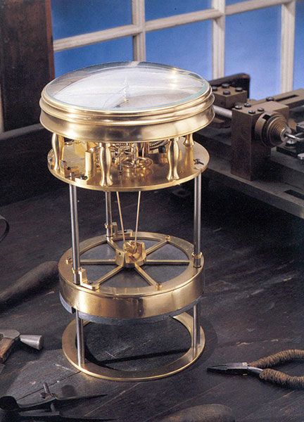
    Navigating at Sea is an immersive environment that suggests a walk through a 19th-century sailing vessel. Visitors will learn how centuries ago navigators at sea relied on chronometers and measurements of celestial objects to determine location. This section includes a mariner’s astrolabe, dating from 1602; a Ramsden sextant and dividing engine; several chronometers; a model of Galileo’s pendulum clock; and the earliest sea-going marine chronometer made in the United States, produced by Bostonian William Cranch Bond during the War of 1812. It also features an interactive display that allows visitors to use a sextant to navigate with the stars.

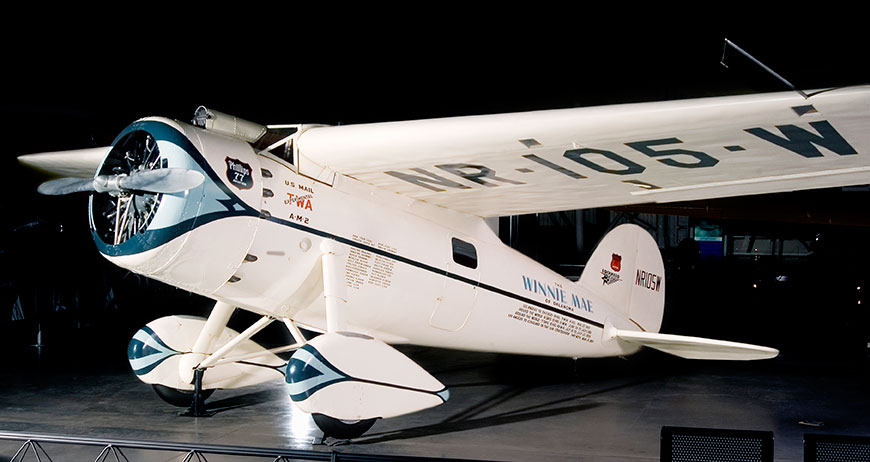
    Navigating in the Air relates how air navigators struggled with greater speeds, worse weather and more cramped conditions than their sea-going predecessors. It tells the story of the innovations that overcame these challenges, as represented the gallery’s largest artifact, the Lockheed Vega “Winnie Mae,” flown by Wiley Post and Harold Gatty, shattering the around-the-world record in 1931. Visitors will learn that Charles Lindbergh required navigational tutoring after he flew to Paris and how he paved the way for a new system of navigation in the process. A personal account by a WWII navigator highlights wartime innovations. This section ends with an explanation of how clocks with tiny quartz crystals opened an entirely new era of navigation in the form of LORAN (LOng RAnge Navigation).

    Wiley Post’s Winnie Mae circled the globe two times, shattering previous records. The first time was in 1931 with Weems associate Harold Gatty as lead navigator. The second was a solo flight in 1933 assisted by “Mechanical Mike,” one of the world’s first practical autopilots.
    Wiley Post’s Winnie Mae circled the globe two times, shattering previous records. The first time was in 1931 with Weems associate Harold Gatty as lead navigator. The second was a solo flight in 1933 assisted by “Mechanical Mike,” one of the world’s first practical autopilots.

    Navigating in Space traces how teams of talented engineers invented the new science of space navigation using star sightings, precise timing and radio communications. This section includes an Apollo sextant, a space shuttle star tracker, timing equipment used at a ground tracking station and a flight spare (duplicate spacecraft) of Mariner 10, the first spacecraft to reach Mercury.

    Inventing Satellite Navigation describes how traveling in space inspired plans to navigate from space. Innovators found that time from precise clocks on satellites, transmitted by radio signals, could be used to determine location. The U.S. military combined several breakthroughs to create the Global Positioning System. Some of the artifacts in this section are the NIST-7 atomic clock that served as the U.S. time standard in the 1990s, the navigation system from the nuclear submarine U.S.S. Alabama, a satellite from the Transit system used for global navigation before GPS and a test satellite global navigation built at the Naval Research Laboratory.

    An official DARPA photograph of Stanley at the 2005 DARPA Grand Challenge. Stanley, created by the Stanford University Racing Team, won the race.
    An official DARPA photograph of Stanley at the 2005 DARPA Grand Challenge. Stanley, created by the Stanford University Racing Team, won the race.

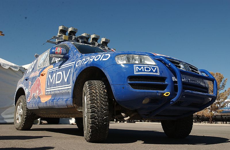
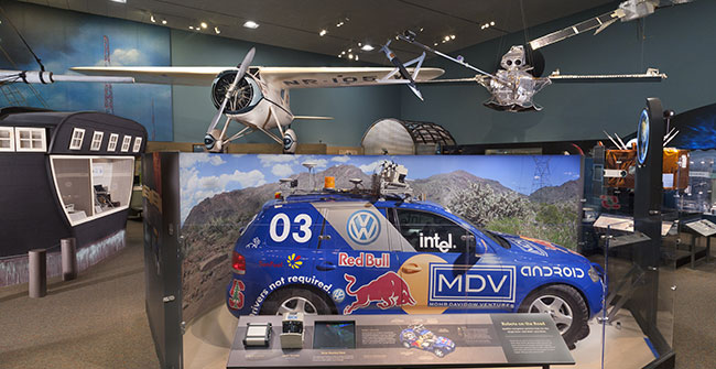
    Navigation for Everyone tells the stories of real people — a fireman, a farmer and a student — who use modern navigation technology in their everyday lives. It also addresses what might come next: the story is not over yet and many new technologies are being developed. This section includes a disassembled mobile phone with a diagram showing all its parts and depicts how hundreds of years of navigation technology are now in the palm of a user’s hand. It also features “Stanley,” the robot car that won the 2005 Grand Challenge, a robot race sponsored by the Defense Advanced Research Projects Agency.

    The exhibition is made possible through the support of Northrop Grumman Corporation; Exelis Inc.; Honeywell; National Geospatial-Intelligence Agency; U.S. Department of Transportation; Magellan GPS; National Coordination Office for Space-Based Positioning, Navigation and Timing; Rockwell Collins; and the Institute of Navigation.

    The National Air and Space Museum building on the National Mall in Washington, D.C., is located at Sixth Street and Independence Avenue S.W. The museum’s Steven F. Udvar-Hazy Center is located in Chantilly, Va., near Washington Dulles International Airport. The National Museum of American History collects, preserves and displays American heritage in the areas of social, political, cultural, scientific and military history.

  • Trimble Introduces All-In-One Device for Mobile Communications and Surveying Data Collection

    Trimble Slate Controller.
    Trimble Slate Controller.

    Trimble has introduced an all-in-one device for mobile communications and surveying data collection — the Trimble Slate Controller. The Trimble Slate Controller combines the convenience and ease-of-use of a smartphone with rugged durability. Optimized for Trimble Access field software and the Trimble R4 GNSS receiver, the Trimble Slate Controller supports a surveyor’s everyday workflows.

    “Surveyors require mobile, rugged solutions that can readily withstand and perform in the toughest of conditions,” said Erik Arvesen, vice president of Trimble’s Survey Division. “With the introduction of the Trimble Slate Controller, we are providing a rugged handheld device designed to run survey workflows while also delivering the capabilities and convenience of a smartphone.”

    Offering voice, SMS text, and 3.75G cellular data transfer capabilities on GSM cellular networks worldwide, the rugged Trimble Slate Controller enables enhanced connectivity in the field. Its wireless communication capabilities keep surveyors connected to the office. An integrated 8-megapixel camera offers enhanced job documentation and point attribution by providing geotagged, high-quality digital photos. 

    The Trimble Slate Controller’s slim, ergonomic design is easy to hold while its screen provides superior sunlight readability enabling all-day use by survey professionals. Designed to withstand even tough conditions, a 4.3-inch capacitive touch Gorilla glass display covers the entire front surface, increasing readability without sacrificing durability.

    Trimble Access field software available on the Trimble Slate Controller offers a variety of features and capabilities to streamline topographic, stakeout, control and other surveying applications. Partnered with Trimble Access and the Trimble R4 GNSS receiver, the Trimble Slate Controller provides a dedicated GNSS solution that is effective for both real time and post-processed GNSS surveys, Trimble said.


  • Shark in the Water! Find out Where

    Shark in the Water! Find out Where

    Did you just watch Jaws? Are you worried your trip to the beach might be interrupted by an unwelcome guest? Now you can go online and see if any great white sharks are visiting nearby waters (the tagged sharks, at least.)

    The Ocearch Global Shark Tracker is a global project to tag and track the navigational patterns of great white sharks in the world’s oceans. The team is currently tracking nearly 40 sharks. The team of scientists have 15 minutes to pull a shark from the water, tag it, and release it, a process which was highlighted in an ABC Nightline feature.

    Ocearch’s founder is Chris Fischer, former star of the History Channel reality TV show “Shark Wranglers.” Ocearch is “seeking to attain groundbreaking data on the biology and health of sharks, in conjunction with basic research on shark life history and migration,” according to its website.

    On the Shark Tracker, sharks that have been tagged appear as bright colored dots. Orange means a ping is less than 72 hours old, green means a ping is less than 30 days old and blue means a ping is more than 30 days old.


  • Handheld’s Ruggedized Computers and Smartphones Have u-blox GPS Inside

    Swedish-based Handheld, maker of mobile computers designed for extreme environments, has integrated u-blox’ GPS modules in four of its most popular products: the Algiz 7 and Algiz 10X tablets, Algiz XRW notebook, and Nautiz X1 smartphone. These tough computers are designed for and used in demanding environments such as polar expeditions, marine exploration, and rescue operations, as well as outdoor industrial applications such as utility maintenance and logistics. The devices depend on u‑blox’ LEA, NEO, and AMY families of compact, high-performance GPS modules to provide reliable navigation and positioning in challenging conditions.

    “Handheld is proud to have achieved an industry-leading position for dependable, ruggedized mobile computers that can be trusted to work in the most hostile environments” said Jerker Hellström, CEO Handheld Group, “To achieve this extremely high-level of performance, we only select components with the highest reliability on the  market. GPS positioning is one of the most important functionalities of our products. For this mission-critical feature, we chose u-blox.”

    Handheld’s lineup of rugged PDAs and mobile computers is specifically developed for use in tough environments in industries such as geomatics, logistics, forestry, public transportation, construction, mining, field service, utilities, maintenance, public safety, military and security.

  • Trimble Acquires Penmap Software for Survey and Cadastral Markets

    Trimble has acquired a suite of software solutions from Penmap.com Ltd. of Bradford, United Kingdom. Penmap.com’s solutions include both office and field data collection software specifically designed for the cadastral and surveying markets. The comprehensive software suite enables Trimble to further address local application requirements and customer needs by providing complete customized surveying software solutions for the cadastral market, the company said. Financial terms were not disclosed.

    The software solutions include:

    Penmap encore: A new solution specifically designed for PDAs and handheld GPS receivers running Windows Mobile operating system. The software’s revolutionary user-friendly interface takes advantage of virtually the entire display screen to maximize map real-estate and is designed for fingertip operation.

    Penmap encoreT: A new premium data collection software specifically designed for tablet PCs running Windows 8, 7, Vista or XP operating system. Its user interface shows collected data on the map in real-time. This feature gives users peace of mind that they have collected data correctly before leaving the site, Trimble said.

    Penmap Office: An intuitive office platform for Penmap encore software. The office software streamlines the land administration professional’s workflow — from project preparation and importing data to managing large raster and vector background maps collected in the field, Trimble said.

    “Penmap.com has built a very close and successful relationship as a customer of Trimble for many years,” said Erik Schütz, managing director for Penmap.com Ltd. “Since Penmap.com was founded, our vision has been to focus on the local requirements of the regional markets we serve and provide those customers with a fine-tuned and easy-to-use solution. The software is an ideal fit within the Trimble portfolio of solutions to address the cadastral market.”

    “The acquisition of Penmap.com’s software suite of office and field solutions reinforces Trimble’s continued commitment to the cadastral market, as well as our focus on providing customers with complete solutions that are customized for local market requirements,” said Matt Delano, business area director for Trimble’s Land Administration Solutions. “Penmap.com’s strength lies in its ability to customize surveying software applications for regional markets, providing users the most intuitive work processes for optimal efficiency and productivity, making it a perfect fit for our customers.”

  • Topcon HiPer SR and Pocket 3D Provide Help to Construction Sites

    HiPer SR_construction_Topcon
    Topcon HiPer SR and Pocket 3D in the field.

    With the introduction of a new version of Pocket 3D software for its HiPer SR GNSS receiver, Topcon Positioning Systems is expanding the delivery of high-accuracy 3D positioning technology to contractors needing a low-cost, one-man layout and measurement system.

    Pocket 3D is powerful, easy-to-use data collection and control software for grade checking and other measurement applications on a job site. Version 10.0.2 makes it fully functional with the HiPer SR receiver, introduced in August.

    The new receiver is not only “perfect for contractors, but also for other non-traditional GNSS users such as landscape architects, law enforcement forensics projects or any others requiring high-accuracy 3D positioning,” said Tony Vanneman, Topcon construction products marketing manager.

    Its field-rugged and fully-integrated design delivers a 1,000-foot working radius through Topcon’s new LongLink technology. “This innovative wireless data link was developed specifically for the HiPer SR, and provides reliable and interference-free base-to-rover communications that don’t require an FCC license to operate,” Vanneman said.

    “We took the best signal tracking technologies and packaged them in a small, energy-efficient design,” he said.  “Anyone looking for a rugged, easy-to-use, low-cost 3D GPS system will find what they need in the HiPer SR.”

    Additional key features of the HiPer SR include:

    • Shock-resistant magnesium alloy housing – allowing the HiPer SR to take a 6 ft. (2m) pole drop onto concrete;
    • Weighs 1.8 pounds (0.8kg);
    • 226-channel Vanguard technology, featuring Universal Tracking Channel technology, supports all satellite constellations;
    • Fence antenna technology;
    • Quartz lock loop technology for superior GNSS tracking in high-vibration environments, such as on a four wheeler;
    • Capable of simultaneous LongLink operation with multiple rovers;
    • Sealed battery pack provides more than 15 hours of operation.
  • HiPer V Featuring Vanguard Technology Offered by Topcon

    HiPer V Featuring Vanguard Technology Offered by Topcon

    Topcon has introduced the HiPer V receiver, which features Topcon’s Vanguard technology. The HiPer V provides users with the choice of GPS and GLONASS signals (as well as Galileo when operationally available), and also includes a variety of choices of internal radio, cellular and Bluetooth communication options and what Topcon calls a state-of-the-art power supply.

    The core of the HiPer V is the new Vanguard GNSS technology, according to Ewout Korpershoek, Topcon senior vice president and chief marketing officer. With its 226 channels and Universal Tracking, the Vanguard chipset is future proof, as it will track signals from all available and currently planned GPS, GLONASS and Galileo satellites.

    “Topcon’s Universal Tracking provides a whole new definition of ‘channel technology.’ There is nothing available like it. Universal Tracking allows a single receiver channel to ‘automatically’ select and track any satellite signal,” Korpershoek said. “Because our channels are not pre-programmed to receive only one specific signal or a type of signal, Topcon users will always receive the maximum number of signals at any given time. In addition, Topcon’s Universal Tracking will automatically weigh the best combination of available signals based on health, geometry and application, providing unmatched accuracy, speed of initialization and fixing. HiPer V will work at places where other receivers will not, at highest accuracy, and with greatest ease of use.”

    Other features include the rugged, durable magnesium alloy housing, the choice of communication options, “and longest life rechargeable battery while maintaining the lightest weight in its class,” Korpershoek said.

  • Esri Announces 24 Organizations to Receive $2 Million in GIS Imagery Grants

    Esri and PCI Geomatics announced they have selected 24 organizations to develop and apply innovative methods for using GIS to analyze imagery for land-use management. Through the Esri Natural Resources Imagery Grant Program, Esri, the world leader in GIS, and PCI Geomatics, the world leader in geoimaging, provide each grant recipient with software and data valued at $100,000.

    “Esri is committed to the development of tools and processes that advance the use of imagery for geospatial analysis,” said Lawrie Jordan, Esri’s imagery solutions director. “The applications that participants design will offer proof-of-concept models useful to imagery analysts worldwide.”

    According to the announcement, participants are required to improve efficiency, productivity, or accuracy for detecting and analyzing land-cover change using MDA synthetic aperture radar (SAR) imagery from RADARSAT-2 and 5 m multispectral imagery from RapidEye. They will use Esri and PCI software to process and analyze imagery. Grant participants, project titles, and organizations are listed on the Esri Natural Resources Imagery Grant Program web page.

    “Imagery provides a cost-efficient means to monitor and measure what is happening on the ground and can be integrated with GIS to make better decisions,” said Terry Moloney, president and CEO of PCI Geomatics. “Our partnership with Esri on this program will significantly change the GIS approach participants will apply to land-use management, planning, and policy making.

  • Avenza Releases MAPublisher 9.1 for Adobe Illustrator

    New ability to export HTML5 web maps and enhanced MAPublisher LabelPro features.

    Avenza Systems Inc., producers of the PDF Maps app for iOS and geospatial plugins for Adobe Creative Suite, including Geographic Imager for Adobe Photoshop, has released  MAPublisher 9.1 for Adobe Illustrator.  MAP Web Author now has the ability to export HTML5 web maps (in addition to the already available Flash output), which are suitable for mobile devices such as tablets and smartphones. In addition, the MAPublisher LabelPro extension has been updated to include the ability to use label filters and expressions for even more detailed labeling as well as a redesigned and more flexible user interface.

    “MAPublisher 9.1  now supports the export of HTML5 web maps. We’ve seen a growth in online mapping and the upward trend of using HTML5 technology to make websites more interactive and interesting. More importantly, map makers and webdesigners alike can extend their HTML5 web maps to smartphone and tablet browsers without the need for additional plug-ins,” said Ted Florence, President of Avenza. “With this new version, we are seeing increased labeling performance, detail, and flexibility.”

    Enhancements and new features of MAPublisher 9.1: MAP Web Author HTML5 export; MAPublisher LabelPro redesigned interface, new label filters feature, and improved performance; Various user interface and performance enhancements to improve usability

    MAPublisher for Adobe Illustrator is powerful map production software for creating cartographic-quality maps from GIS data. MAPublisher tools leverage the superior graphics design capabilities of Adobe Illustrator to manipulate GIS data and to produce high-quality maps with accuracy and efficiency.

  • SuperGIS Engine 3.1 Beta Version Released

    SuperGeo’s beta version of SuperGIS Engine 3.1, the collection of COM GIS components for customizing GIS applications, is now available.

    Integrating with map and GIS technologies, SuperGIS Engine 3.1 is the collection of COM-based components developed by SuperGeo. As the product of core components in SuperGIS series software provided for developers, SuperGIS Engine 3.1 can be embedded into programming language under Windows developing environment to integrate with other systems and enhance efficiency of system developing.

    SuperGIS Engine 3.1 provides 32-bit and 64-bit developing components that enable developers to develop GIS applications they need in common development environments such as Visual Studio 2005/2008/2010 Visual Basic, VB.NET, Visual C# and so on.

    Furthermore, SuperGIS Engine contains hundreds of GIS-related objects that allow developers to customize various applications elastically and achieve diverse GIS manipulation functions like layers overlaying, map viewing and querying, geoprocessing, etc.

    SuperGIS Engine 3.1 Beta is released. Users, who are interested in SuperGIS Engine 3.1, please visit SuperGeo website: http://www.supergeotek.com/ProductPage_SE.aspx , or contact us with e-mail: [email protected] .

  • Leica Geosystems Opens Online Store

    Leica Geosystems Inc. has announced the launch of the e-commerce site for Leica Geosystems Solutions Centers. The grand opening of the Leica Geosystems Solutions Center is marked by an unprecedented online-only promotion.

    Providing 24/7 personalized access to the products essential to the surveying, engineering, and construction industries, the site is a resource for more than purchases. It also enables customers to compare thousands of products based on features, shipping options and availability, and to create wish lists.

    The Leica Geosystems Solutions Centers e-commerce site offers a range of supplies, accessories and rentals, from paint and flagging, safety supplies, total stations and GPS systems for surveying, construction lasers and building layout systems. Relevant products and pricing are presented based on each customer’s unique profile, and subscription and quick-order capabilities make it easy to reorder frequently needed products.

    “We are committed to continually delivering value to our customers, and it is exciting to respond to customer needs by bringing this e-commerce site to the market,” said Mike Strom, general manager, Solutions Centers for Leica Geosystems. “Our customers are busy, and they often need to place orders outside of standard business hours. Our new e-commerce website provides customers a more convenient way to buy from us, and we will be offering online-only promotions on a regular basis — similar to the tremendous grand opening deals — so it’s easier than ever for customers to begin reaping the benefits of Leica Geosystems solutions.”

    The Leica Geosystems Solutions Center is factory-owned and operated, which guarantees that customers will receive the quality products and service expected from Leica Geosystems, the company said. Additionally, because support is critical at every step of the way, even during the purchase process, the site features multiple avenues to online support: customers get answers from factory-trained experts.

  • Nokia To Acquire earthmine 3D Imaging Company


    earthmine, Inc., announced today that it is has entered into an agreement to be acquired by Nokia. earthmine, based in Berkeley, California, is a privately owned company that develops a powerful end-to-end 3D street level imaging solution — from collection hardware to processing workflows, cloud hosting and client software.

    The earthmine team is expected to join the Nokia location and commerce business, and Berkeley will become a key site for the development of 3D reality capture technology. “We are very excited to be joining Nokia, a company with a huge presence and vision in mapping,” said John Ristevski, co-CEO of earthmine Inc. “We could not hope for a better place to fulfill and accelerate our mission of indexing the world in 3D.”

    The transaction is expected to close by the end of 2012. The terms of the transaction are confidential.

    earthmine, Inc., provides 3D street-level imagery, delivering an end-to-end solution including 3D mobile mapping systems, automated data-processing pipelines, cloud-based hosting services and server software, desktop software, client-side developer tools, and direct integration with GIS software. earthmine technology is being used in local search, mobile, mapping, GIS, safety, and security markets in the United States, Mexico, Brazil, Canada, France, Australia, Japan, Malaysia, Singapore, Korea, Saudi Arabia, as well as other countries around the world.