Swift Navigation has partnered with Taiwan Mobile, a major telecommunications company in Taiwan, to introduce the Skylark Precise Positioning Service to the Taiwanese market. This collaboration aims to meet the increasing demand for high-accuracy positioning solutions across various industries.
Skylark is a real-time GNSS correction service that enhances positioning precision to the centimeter level by correcting signal errors from GNSS. It is the first cloud-based precise positioning service developed specifically for large-scale applications, designed to deliver accuracy, reliability, and safety worldwide. The service utilizes advanced atmospheric modeling to reduce errors from ionospheric disturbances, clock drift and satellite orbit inaccuracies, improving location accuracy from several meters to just a few centimeters.
The service is supported by a carrier-grade network consisting of modern ground reference stations, which have been designed and operated collaboratively by Taiwan Mobile and other mobile network operators globally. Skylark’s highly reliable and precise positioning capabilities are expected to support emerging applications in automotive, robotics, and fleet management sectors. In automotive applications, it is the first and only automotive safety integrity level (ASIL) certified, real-time cloud-based positioning service compliant with ISO 26262:2018, enabling safe operation of advanced driver-assistance systems (ADAS) and autonomous vehicles.
For robotics, Skylark’s proprietary atmospheric modeling offers centimeter-level accuracy with extended baselines and automatic failover, ensuring reliable performance for devices such as robotic lawnmowers and surveying drones. In fleet management, the service provides a cost-effective, dependable positioning solution optimized for battery-powered devices, facilitating efficient last-mile and final-inch logistics, and integrating with a broad range of compatible GNSS hardware.
A roundup of recent products in the GNSS and inertial positioning industry from the December 2024 issue of GPS World magazine.
Mapping
Photo: SPH Engineering
GPR System For terrestrial and airborne applications
The Zond Aero 500 NG is a versatile ground penetrating radar (GPR) system designed for both terrestrial and drone-mounted surveys, suitable for applications such as utility scanning, sinkhole detection, glaciology and geological studies. It operates in dual mode, allowing for ground-based and airborne surveys, enhancing data collection flexibility. Key specifications include a center frequency of 500 MHz, an operating bandwidth of 200 MHz – 900 MHz, a sampling rate of 25,600 samples per second and a scan rate of 50 scans per second, with depth penetration up to 4 meters in average soil conditions. The system features advanced electronics for real-time data collection, which can significantly improve the signal-to-noise ratio. It is compatible with DJI Matrice 300/350 UAVs for airborne applications.
Streamlined Lidar Mapping YellowScan’s Surveyor Ultra integrated with DeltaQuad Evo
Integrating YellowScan’s Surveyor Ultra with the DeltaQuad Evo platform allows users to collect high-precision, high-density data across 1,200 hectares in a single flight while simultaneously capturing lidar and RGB data.
DeltaQuad Evo’s long-range flight capabilities and efficient vertical take-off and landing (VTOL) design, paired with the Surveyor Ultra’s lidar technology, allow users to streamline their workflows to reduce time spent in the air and on post-processing tasks, making it particularly beneficial for large infrastructure projects, forestry analysis and environmental monitoring. The system can be used for surveying, construction, forestry and environmental research.
Airborne Mapping System With a ‘cross-fire’ scan pattern
The VQ-1560 III-S is a dual-channel laser scanning system designed for airborne mapping applications. Its “cross-fire” scan pattern allows for simultaneous forward and backward viewing at the edges of the swath, along with a nadir view in the center. This configuration optimizes point distribution for effective target sampling. With pulse repetition rates reaching up to 4.4 MHz, the VQ-1560 III-S can operate at altitudes of up to 1,600 m above ground level (AGL). At a lower pulse repetition rate of 560 kHz, it can function at altitudes as high as 3,900 m AGL.
The system features inertial measurement unit (IMU) and GNSS integration, with the option to include one or two high-resolution RGB/NIR cameras. It is ideal for professionals in fields such as urban planning, forestry and environmental monitoring.
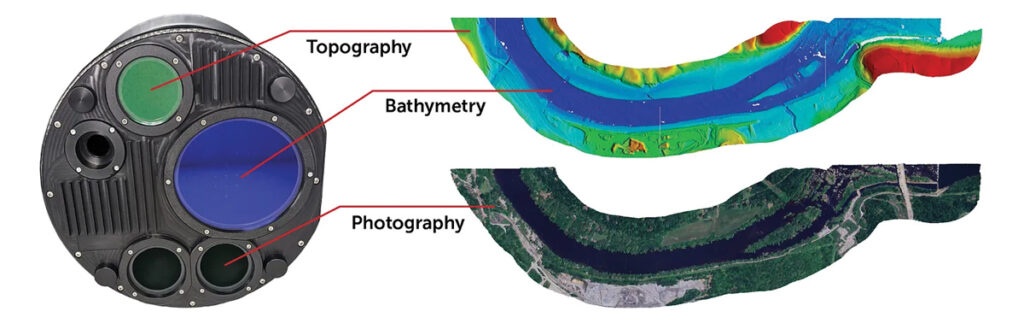
This bathymetric lidar system is designed for coastal and inland water mapping. It combines high-resolution topographic and bathymetric capabilities, allowing for seamless data collection across land and sea. It can be used for coastal zone management, environmental monitoring, infrastructure planning and more.
Fathom delivers data quickly by leveraging real-time quality control with Onboard and scalable processing with a CARIS workflow. It also includes a built-in topographic lidar and a multispectral camera for coastal surveys at a coverage of 50 km2/hour.
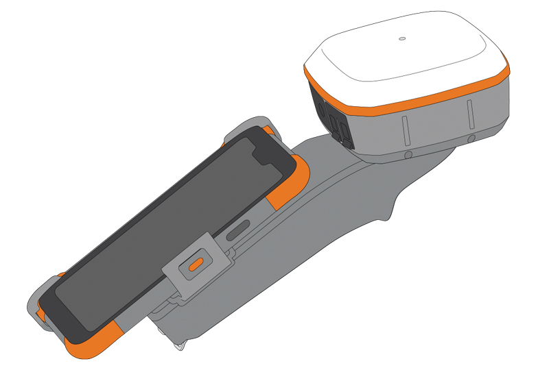
The Geode Grip is a mounting accessory featuring a specialized bracket. It allows users to securely attach smartphones directly to Juniper’s Geode GNSS receivers, offering an integrated and streamlined data collection solution.
The Geode Grip is a tool designed for professionals in surveying, mapping and geographic information systems (GIS) to enhance mobile data collection. It replaces the traditional survey pole with a handheld setup that aims to improve ergonomics. It is ideal for field projects that require precise location data and mobile data collection, such as environmental research, land surveying, agriculture and infrastructure engineering.
New Product Bundle For high-accuracy GNSS applications
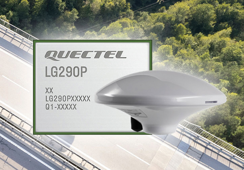
Quectel Wireless Solutions has unveiled a new product bundle designed to facilitate the development of high-accuracy GNSS applications. The bundle includes the LG290P GNSS module, which is a quad-band, multi-constellation device capable of receiving signals from various satellite systems, including GPS, GLONASS, Galileo, BDS, QZSS and NavIC. The LG290P is engineered for high precision and supports RTK positioning, allowing for centimeter-level accuracy even in challenging environments. It can be used in diverse applications, such as autonomous vehicles, precision agriculture and surveying.
In addition to the LG290P module, the bundle includes options for either the YEGN103W8A geodetic antenna or the YEGD006U1A patch antenna. Both antennas are designed to operate within the same frequency bands as the GNSS module and are compliant with environmental regulations such as RoHS. This pre-integrated solution simplifies developers’ procurement and integration process by providing a one-stop solution that combines antennas with GNSS modules and RTK correction services.
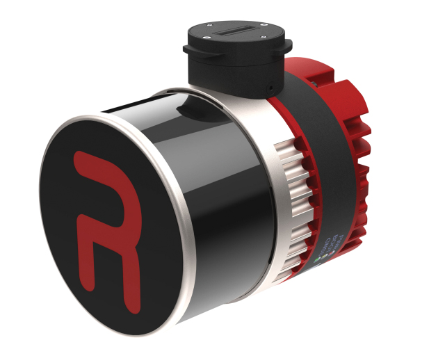
Lidar Camera Payload For surveying and mapping applications
The RESEPI Ultra LITE is a lightweight payload combining lidar and camera technology for advanced surveying and mapping applications. The system integrates the XT-32 lidar scanner to offer users advanced data accuracy and point density across various operational modes.
It has a compact design with a 5MP colorization camera, making it ideal for small unmanned aerial systems (SUAS) with strict volume constraints. It can be used for aerial and ground-based applications, including utility mapping, construction volumetrics, precision agriculture, forestry, site surveying and mining. Designed for seamless integration, the system is compatible with a wide range of platforms such as Freefly, WISPR, DJI, Sony and mobile setups. Inertial Labs’ proprietary SnapFit adapters ensure quick and secure mounting to enhance the system’s adaptability.
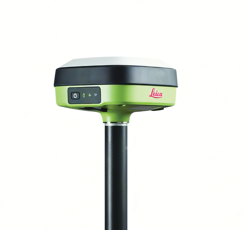
The Leica GS05 is a compact and lightweight GNSS smart antenna designed for surveying tasks, featuring calibration-free tilt compensation. This robust device allows for accurate measurements even when the survey pole is tilted up to 30°, enhancing data collection in challenging environments. Its integration with Leica Geosystems’ portfolio, including Leica Captivate software and total stations, seeks to maximize efficiency. The GS05 can function as both a base and an RTK rover, supporting single base stations and RTK networks such as Leica SmartNet.
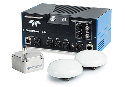
Intrepid is a GNSS/INS system integrated with the SeaBat T20-ASV processor and includes a compact IMU and two GNSS antennas, ensuring reliable and precise positioning.
It can automatically stream data to third-party software. This eliminates the need for manual sensor interfacing and reduces downtime. The Intrepid GNSS/INS benefits users in marine surveying applications by providing the precise navigation necessary for operational efficiency. Its intuitive design allows for simple configuration.
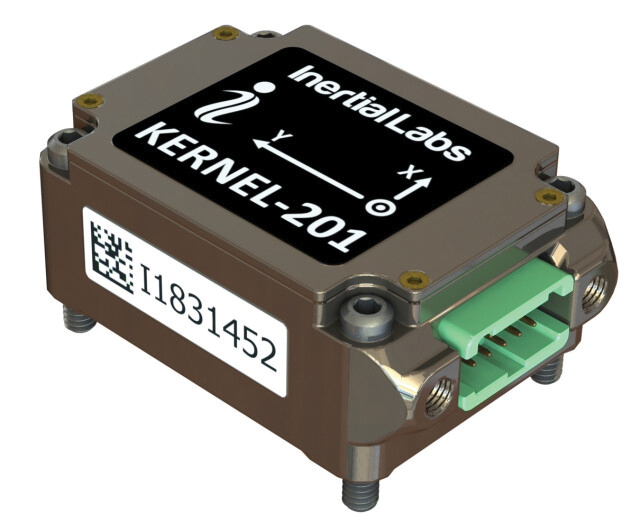
Miniature MEMS Sensor-Based IMU Can withstand high shock and vibrations
The KERNEL-201 features three-axis MEMS accelerometers and gyroscopes that offer ultra-low noise, high bandwidth and minimal latency. These characteristics make it ideal for applications such as pointing, stabilization and navigation in systems where performance and size are critical. Its volume of 0.38 cubic inches offers a high dynamic range.
Fully calibrated and temperature-compensated, the unit offers consistent, precise measurements even in challenging environments. It features an in-run bias stability of up to 0.7 deg/hr for gyroscopes and 0.005 mg for accelerometers, along with a low angular random walk (ARW) of 0.065°/√hr and velocity random walk (VRW) of 0.015 m/sec/√hr.
The unit is designed to withstand high shock and vibration while maintaining peak performance, making it suitable for a wide range of challenging applications. The KERNEL-201 can be integrated into various high-level systems, such as motion reference units (MRUs), GPS-aided inertial navigation systems (INS) and attitude and heading reference systems (AHRS). It offers continuous built-in testing (BIT), customizable communication protocols and flexible power options.
Smart Choke Antenna Offers comprehensive GNSS signal reception
The VCS6000XF full band smart choke antenna is engineered for CORS applications. It combines Tallysman Verachoke antenna elements with Septentrio’s Mosaic X5 full-band receiver to offer an integrated solution for OEM CORS systems.
The VCS6000XF offers comprehensive GNSS signal reception, including GPS/QZSS L1/L2/L5, GLONASS G1/G2/G3, Galileo E1/E5a/E5b/E6/E5 AltBoc, BeiDou B1/B2/B2a/B3, NavIC L5, SBAS and L-Band correction services.
The antenna features a 0.5 mm phase center variation and utilizes Calian’s eXtended filtering for near-band signal interference mitigation. The integrated Septentrio Mosaic X5 receiver provides capabilities such as anti-jamming, anti-spoofing, scintillation mitigation and receiver integrity by combining the antenna and receiver in the choke ring antenna.
Do you remember the free-standing car navigation devices that were popular for a while, such as those made by Garmin and Magellan? Few people use them anymore because to find our way when driving, most of us use our smartphones instead.
Smartphones now have a plethora of sensors, including inclinometers, accelerometers, magnetometers, barometers and light sensors. However, cost and size constraints (the insides of those small devices are so crowded!) limit the accuracy of smartphones’ GNSS receivers.
Therefore, to accomplish professional mapping tasks, it is now increasingly common to pair a smartphone — which provides computing power, a display, motion sensors, a camera and Internet connectivity — with an external GNSS receiver and antenna.
This and other changes in the industry make product categories long in use obsolete or, at least, less compelling. What is a mobile GNSS solution? Are the terms “mapping grade” and “resource grade” still useful? Who is using which devices for which tasks?
I discussed these issues with Bernhard Richter, VP Geomatics at Leica Geosystems, which is part of Hexagon, and with Igor Vereninov, CEO of Emlid.
— Matteo Luccio, Editor-in-Chief
Leica Geosystems: Conversation with Bernhard Richter, VP Geomatics at Leica Geosystems, part of Hexagon
We used to divide GNSS receivers into consumer grade, resource grade (for GIS data collection) and survey grade.
Those lines don’t exist anymore to the same extent. Some of the lower-cost chipsets — which were originally built for mobile phones and Garmin devices and lower-accuracy stuff — can now provide higher accuracy. We call them industrial-grade chipsets. The need for UAVs, e-scooters, e-bikes, automotive applications, etc., triggered their development. They are coming closer to the premium boards — let’s call them the multi-frequency, multi-constellation receivers that were always built for real-time kinematic (RTK)-type applications.
So, it’s the bottom that’s coming up.
There is still a need for single frequency code-only chips on the one hand for the mass market and, on the other hand, for premium devices from companies such as NovAtel (part of Hexagon), Trimble, Hemisphere and Septentrio. There is a new tier, which we call industrial grade, from companies such as u-blox and Unicore, which come a bit closer to the premium segment.
I’ve always thought of location-based services (LBS) as using consumers’ locations to connect them with retail and services. People use their smartphones to find the nearest coffeeshop, but what has not happened is coffeeshops saying, “Hey, I see that you are within 500 feet of our store. You should come in, because we’ll give you a discount.”
In our field, we make money by providing decimeter- or centimeter-level solutions to our users for surveying, machine control, GIS, etc. When it comes to needing locations for other applications, such as retail, everything is already nicely integrated in smartphones, and consumers just utilize what is there.
In order to get a better precision than the one provided by the cellphone, you need a small, extra GNSS device connected to the cell. Then, instead of using the position provided by the phone, the application will use that much better position. That trend will go on for quite a while. This is the change to what was standard in the last decade, when we built dedicated handheld controllers with fairly high-cost chipsets to enable GIS applications. These GIS devices seem to be disappearing. It’s either an Android or iOS-based phone or tablet, and now you add a hockey puck-type GNSS antenna. Then, you override or mock the position that is coming from the internal chipset on the phone, and the app uses that more precise position. That is the new standard for GIS, so to speak.
Analogously, for a decade we had dedicated car navigation devices. They disappeared because our phones now do that.
Exactly. Where we can really add is in providing that extra bit — not only hardware, but also software and services. Decades ago, we developed the HxGN SmartNet RTK service. Now, we also have HxGN SmartNetGlobal, which is both a terrestrial-based service and augmented by a satellite-based precise point positioning (PPP)-type service. Simple car navigation devices such as those by Garmin or dedicated GIS controllers have almost vanished. It’s always a smartphone or a tablet plus, if a centimeter-level solution is needed, an additional device.
It does not make a lot of sense to fully integrate high-precision GNSS into these mobile devices, because the customer group who really needs a centimeter-type solution is too small, and it would put an extra burden on the engineering for the tablet or the smartphone. Nobody complains if you attach a device that weighs a few hundred grams. I also think that you shouldn’t integrate things that don’t belong together. The different components have different life cycles. A smartphone today is old when it’s 18 months old, right? But, with the volume that’s sold to customers needing high precision, we cannot renew the equipment every year.
Are you talking about a smart antenna?
Today, a GNSS chipset can be as small as a two-Euro coin. However, if you want to do high-precision GNSS, you still need a decent-sized antenna. So, you cannot go to a fingernail size with the antenna element. If you need a good amount of multi-pass mitigation in the analogue way, you need a beer coaster-sized ground plane. Now, typically, you also put in a MEMS-based inertial measurement unit (IMU), so that you do more than just the pure GNSS position — pitch, roll and yaw are important as well.
Phones already have IMUs.
It’s always a matter of what you want. Do you want five meters or one meter or sub-decimeter repeatable at high reliability? Then you need to add more, higher-value components, right? Also, if you just take what’s in an iPhone, it’s not so easy to calibrate those MEMS. Engineers could probably solve the problem, but precision is never the primary goal for a smartphone and would increase complexity.
In addition, in an iPhone, you don’t really worry about aging of the components or whether they can survive a fall from 1.5 m. So, we look at the application and the environment in which the customers are using it, then we select the best components to really add value to, let’s say, the existing iPhone’s position.
In September, we released a high-grade antenna about the size of an ice hockey puck with a very small and tightly integrated GNSS chipset and inertial measurement unit (IMU). Then, of course, we have our own processor to run our positioning engine. It brings in all the corrections that we can provide with our SmartNet service. So, we provide a centimeter solution and pitch, roll and yaw in the most compact form.
Then the phone becomes just the interface.
Yeah, the phone position gets mocked by the position, for example, from a FLX100 plus, and the app takes the better position.
The app is the user’s interface with the puck.
Yes, but the survey device — the “GNSS puck” together with the phone running the app — is only one element of what a typical GIS user needs. Most important are the data themselves and the cloud system that hosts them. The data are the key enablers. If you think of Esri, for example, their value is hosting the data, having the geospatial relationship between the data and enabling decision-making.
The geospatial acquisition part became really easy and can even be done in a tilt-compensated way, so you don’t even need to level your survey pole. The surveyed points are typically automatically synchronized or uploaded to the cloud system. So, if you say that the phone is just the user interface, I kind of disagree.
A utility technician using the Leica GS05 GNSS receiver for the surveying and utility industries, which Leica released in September. (Photo: Leica Geosystems)
You’re collecting data and feeding them to the cloud, but they are also on the device to display.
The data themselves are only stored inside the app or in the cloud and can be displayed. The GNSS device itself keeps streaming the position but nothing gets stored there.
How much do you collaborate with ESRI, in terms of their application and the data?
Jack Dangermond [Esri’s co-founder and president] once said, “portal to portal is key these days.” At Hexagon, we have our applications, our industries and our focus areas, and ESRI has its. To me, the way to be successful is to have systems that are compatible and portals that can talk to each other. So, to me, portal to portal is and will be key.
You mean the portals in the cloud?
Yes, they have an API interface and they can talk to each other. I’ll give you one concrete example. We have a product called the FLX100. It is a little puck, has a helix antenna, a receiver engine, but does not have a cellular phone integrated. We’re using the cellular connection of the user’s mobile phone. So, you connect the mobile phone to the FLX100.
We have software called Zeno Mobile One that has an Esri interface. So, we can immediately synchronize everything we measure with ArcGIS Online and ArcEnterprise. This is how we developed our GIS asset collection software. We need an accurate position, of course, which we provide through the hardware that we sell with the FLX100 plus. It can also connect to any RTK service — but, ideally, we connect to our own SmartNet service. As soon as we collect an asset — such as a pipe, a fire hydrant or a manhole — the operator annotates it, “This is a manhole, this is a gas pipe, this is a water pipe,” whatever. Then, the data can be uploaded immediately, already in the right file structure, e.g. into an Esri environment.
We can also run an Esri product, such as ArcGIS Field Maps, on the smartphone and still talk to our hardware. This is very interchangeable these days. If you’re not doing this, I think you limit yourself too much when it comes to data collection. We understand the whole workflow much better than in the past and can be open to certain services, such as Web Map Service (WMS) or Web Feature Services (WFS). You can download the map of your town, then download, let’s say, the entire public water system and load it into this map. Then you can make changes, add new pipes, etc. So, there are many services that enable you to add to an existing map.
So, you’re using Esri’s APIs like anybody else.
Theoretically, you’re right; we use those published interfaces. However, we are Esri Gold Partners, so we really work with Esri to make this happen. There are also open-source products, such as QGIS.
What do you mean by “industrial-grade” receivers?
UAVs doing high precision photogrammetry are one of the biggest market for RTK positioning. However, the highest-end boards from the likes of NovAtel (part of Hexagon) and Trimble are less often used in these applications nowadays. So, UAV manufacturers and operators switched to smaller, lower-cost chipsets. This is one area where this field developed. We are talking about hundreds of thousands of UAVs. So, it became a significant market.
Also, today lawn mowers do not just follow random patterns on lawns. They start integrating those more high-precision chipsets. These days, they are more and more multi-frequency, multi-constellation.
Who’s using something like the puck that you were describing earlier? It’s neither average consumers nor surveyors.
It’s a very good question. We still need to differentiate between the high-precision geodetic market or the scientific market where highest reliability is needed and the GIS market where reliability is of lesser priority. In many cases, such as high multipath, foliage coverage and jamming — there are typically no anti-jamming tools on these lower-cost chipsets — there is a strong need for highest end GNSS cards and a significant difference. Nevertheless, the GIS market is still of significant market size.
Every fiberoptic cable that’s being put underground these days in countries such as Germany, Austria and Italy must be mapped on the open trench. It would be quite costly for those companies who put the fiber optic cables into the ground to call a surveyor each time. So, they train their own technicians to do the job and need many handheld units. We have customers who need 100 crews equipped with the same GNSS equipment. That is the kind of customer group that needs this mid-tier of products.
There are other markets for the mid-tier products, such as photogrammetry, which is coming back because of the improvements in digital cameras and the power of the processors in the field, and then everything with augmented reality. This customer group still needs some control points or RTK positions, but they typically don’t want to spend too much on highest precision equipment.
What is new about the FLX100 plus?
We integrate it into the world of mobile devices in a new way. It is a change from an integrated handheld controller to something that’s separated from the tablet or the smartphone. From an accuracy point of view — if we’re not talking about very challenging cases such as heavy foliage or multipath and 50 km baselines — the FLX100 plus is really good. I think we are at the level where we were with the highest-grade GNSS equipment in 2005 or 2010.
At GPS World, we have used the term “mobile solutions” for a long time but, as the technology changes, it’s hard to use the same categories.
The mid-tier and high-end premium will increasingly blur. So, there isn’t such a clear line anymore. The distinction will disappear, not the equipment itself, for those who want the highest reliability — such as surveyors, who typically earn their living by putting their stamp on a map or a plan and are liable for errors. These customers want the best possible also under very difficult conditions.
Emlid: Conversation with Igor Vereninov, CEO at Emlid
What does Emlid do? How large is it? Where is it based?
We build high-precision RTK receivers and software for them. We are based in Budapest, Hungary, and we also have development offices in Belgrade, Serbia, as well as in Lisbon, Portugal. We are more than 100 people now. We are a diverse bunch, developing everything inhouse — including electronics, embedded software, mobile applications, cloud services and beautifully designed enclosures.
Why did you start the company?
I started the company with my co-founder out of my kitchen, 10 years ago. We started with the idea of making RTK more affordable. Back then, survey gear was very complicated, required a lot of training and was super expensive. We were maybe a bit arrogant, being just out of university, and we thought, “Yeah, we should definitely try to disrupt that.” We built super-affordable receivers, completely crowdfunded on Indiegogo, without any outside capital. Our personal money was very limited, so all the money we had in the company came from our future users.
At that time, our receiver was just a board, but from there we saw so much interest and the orders started to flow. We realized, “Okay, this is going to be big, so we better build a fully recognized and waterproof device that surveyors can use in the field and is not just for DIY hackers and geeks.” That’s how it started.
What came next?
We first had the Reach receiver, which was the board, then the Reach RS, the Reach RS+, the Reach RS2 and the Reach RS2+. Now, we have our Reach RS3, which is super-popular worldwide. We’re now widely known, and our receivers are still very affordable, robust, easy to use and as accurate as any other receiver out there.
To me, the term “mobile solutions” refers mostly to data collection for GIS, but these categories are very subjective. What are the key trends you see in the industry?
A big industry trend is that more and more people inside companies are interacting with centimeter accuracy and with RTK. Previously, it was only surveyors, but now we are seeing that an increasing number of people in the field will have access to accuracy. We play a large part in this story because we democratized RTK and brought it to other professionals outside of surveying.
Traditionally, we had RTK accuracy at one end of the spectrum, a GPS receiver inside your iPad or iPhone at the other end of the spectrum, and in between sub-meter devices, which traditionally occupied the GIS space. Now, customers and potential customers tell me that the sub-meter category is becoming less and less present and attractive. As the RTK technology becomes super accessible and affordable, all the consumers from the sub-meter space are shifting toward centimeter accuracy. Maybe they don’t really need it in the field, but they feel like …
They might as well have it!
Yes, why not just have it, right? It’s the same cost, so why not equip our field crews with centimeter accuracy? We now have easily accessible and affordable, or even free, correction networks. The devices themselves now cost less than $2,000 and are easy to use.
That’s the kind of conversation we are having regularly with customers and potential customers. They’re saying, “Why not have it?” They want to upgrade the accuracy of their mobile mapping device — typically, an iPad. It’s not enough to be able to tell, for example, on which side of the pipeline the valve or junction box is. They really would be fine with 10 or 20 cm of accuracy, but then why not go to that 1 cm level?
Another trend is using iPhones and high-precision GPS for site documentation. We now have deployments of hundreds of units in the field using a combination of an RTK GPS receiver with lidar and camera sensors inside consumer-grade devices, such as iPads or iPhone Pros, to document such things as accidents and construction progress — especially for large infrastructure projects, such as fiberoptic networks.
Your Reach RX, for example, is an external device that talks to a tablet, right?
Yes. We’re seeing the use of our receivers in combination with the sensors inside an iPhone to document objects with very high accuracy and with absolutely no training by the person doing the job. You really don’t need a trained person to do it. For example, an excavator operator — who is not typically doing any kind of mapping but is a professional in a different space — would be able to grab an iPhone with an external RTK receiver and map things with centimeter accuracy for reporting purposes.
I find it very exciting that we’re able to use this mix of consumer-grade technology with RTK that is rapidly becoming very affordable. Together, they give us a platform that allows us to document things super-efficiently and bring it into the hands of more professionals. We are seeing more and more startups in that space as well.
All your receivers are GNSS receivers, correct?
Yes, everything that we make is all-constellation and multi-frequency GNSS.
A surveyor using an Emlid mobile RTK network rover, a Reach RX, in an urban environment. (Photo: Emlid)
What are the main end-user applications for your devices?
We sell a lot to land surveyors and to drone pilots. Many drone pilots are increasingly becoming surveyors, and many surveyors are increasingly becoming drone pilots. So, those two groups of people are moving toward each other, and we are happy to serve both. Our devices are very popular and are the standard for drone workflows. This is a big market for us. Also, construction and mobile scanning.
What about utility companies mapping their assets?
Yes, we work with businesses that need to manage some kind of infrastructure or a large collection of assets. Water companies are very big users. They have many undocumented areas and a lot of people working in the field. For them, it’s crucial to have an affordable system that they can put in the hands of untrained people. Also, fiber optic networks, gas pipelines and agricultural companies have similar demands.
Today, a traditional RTK GNSS receiver costs at least $20,000. Our Reach RX is $2,000; our Reach RS3 with tilt compensation is $3,000. This completely changes the game. So, we are opening this field for professionals, for architects, for landscape designers, for agricultural applications. We’re seeing archeologists use it. These guys would have never bought a system for $20,000 or $30,000. Now that it’s $2,000 or $3,000, it’s a different story.
What do you make specifically for GIS?
We recently introduced the Reach RX MFI, which is certified for use with Apple devices. This Reach RX integrates natively with Esri’s ArcGIS Field Maps, the most common platform for GIS data collection workflows. It required certain hardware modifications to connect to iPhones natively and some integration work with Esri. It is another way in which our Reach RX receiver can be used. Every one of our Reach RX is now a Reach RX MFI.
Tell me about the Pix4D.
We have a kit that consists of two parts. The hardware part is our Reach RX centimeter-grade, survey RTK receiver. The software part is the PIX4Dcatch mobile app on an iPhone Pro or Pro Max, which has a lidar sensor and a very good camera. As a part of the kit, you receive a bracket to mount everything together, forming a unique system that is easy to use, accurate and affordable. It uses the lidar for scanning.
And the sensors in the phone to determine its attitude …
Yes, and the huge photogrammetry experience that Pix4D has. They’re using their full photogrammetry engine to process the pictures, along with the lidar from the iPhone and highly accurate GNSS, which allows them to stitch together essentially survey-grade models just using this simple set of equipment.
I’m very excited about this technology being so accessible and easy to use.
A roundup of recent products in the GNSS and inertial positioning industry from the May 2023 issue of GPS World magazine.
SURVEYING
Image: Septentrio
Corrections Program Provides documentation for GNSS receivers
The Agnostic Correction Partner Program facilitates the use of Septentrio GNSS receivers with high-accuracy services that provide varying levels of accuracy, coverage and delivery methods. This enables users to select the service that suits specific applications and business models. The program — which includes Polaris from Point One, Skylark from Swift Navigation, and PointPerfect from u-blox — provides documentation for the use of Septentrio receivers with these high-accuracy services. Agnostic corrections are useful in situations where multiple types of GNSS receivers are being used, such as in a large-scale surveying project. Septentrio, septentrio.com
Image: Inertial Labs
Multi-Application IMU A compact, self-contained strapdown, advanced tactical-grade IMU device
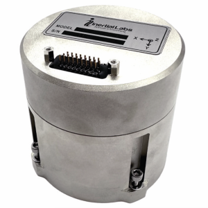
The IMU-FI-200C measures linear accelerations and angular rates with its three-axis, tactical-grade, closed loop, fiber-optic gyroscopes and three-axis, high-precision MEMS accelerometers in motionless and high dynamic applications. The IMU-FI-200C is fully calibrated, temperature compensated and aligned to an orthogonal coordinate system. It contains more than 0.5°/hr gyroscopes and less than 2 mg bias repeatability over operational range accelerometers with low noise and high reliability. Continuous built-in test, configurable communications protocols, electromagnetic interference protection, and flexible input power requirements make the IMU-FI-200C suitable for a wide range of integrated system applications. Inertial Labs, inertiallabs.com
Image: Inertial Labs
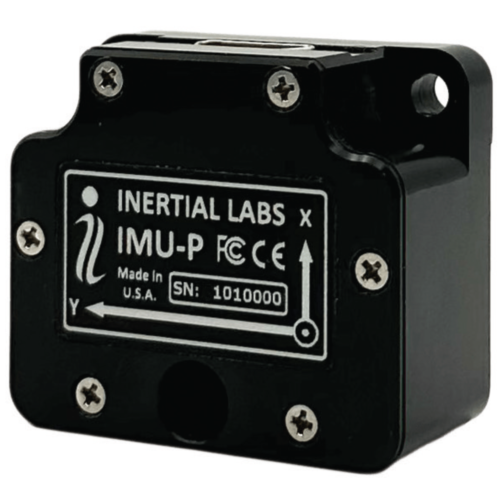
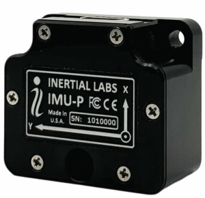
MEMS IMU Suitable for applications such as antenna and line of sight stabilization systems, GPS-aided INS and more
The inertial measurement unit-P (IMU-P) is an advanced MEMS sensors-based, compact, self-contained strapdown, industrial- and tactical-grade inertial measurement system and digital tilt sensor that measures linear accelerations, angular rates and pitch-and-roll with three-axis, high-grade MEMS accelerometers and three-axis, tactical-grade MEMS gyroscopes. Angular rates and accelerations are determined with high accuracy for both motionless and dynamic applications. The IMU-P is fully calibrated, temperature compensated, and mathematically aligned to an orthogonal coordinate system. IMU-P demonstrates less than 1 deg/hr gyroscopes and 0.005 mg accelerometers bias inrun stability with low noise and high reliability. The IMU-P models collect data from an external source of GNSS to output full spectrum inertial navigation system data consisting of positions, attitude, velocity and time.
Inertial Labs, inertiallabs.com
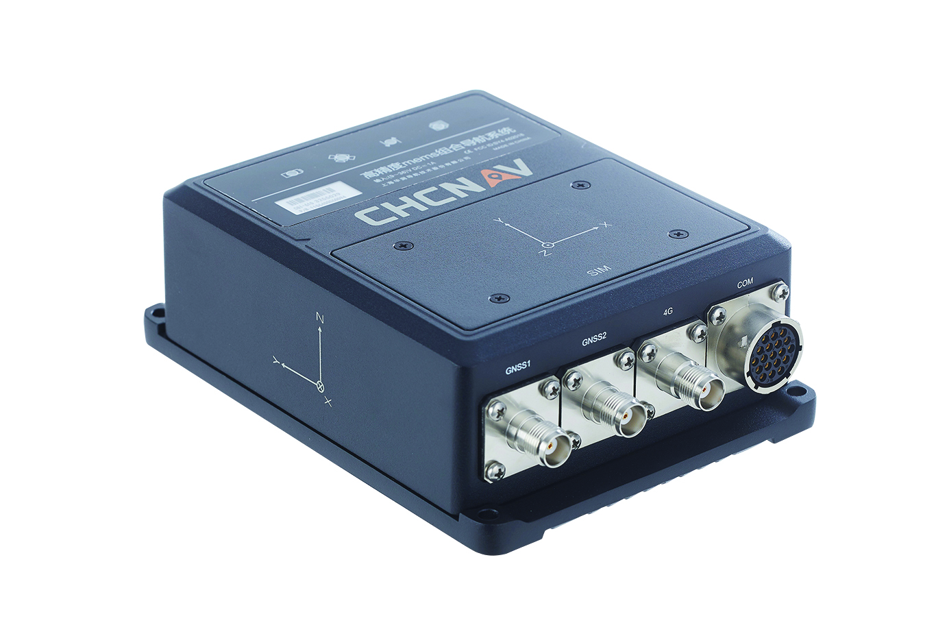
The CGI-610 GNSS/INS sensor is an advanced dual-antenna receiver designed for reliable and accurate navigation and positioning in challenging terrestrial, marine or airborne applications. Designed to meet the needs of 3D positioning and autonomous vehicle guidance applications, it provides high performance in urban canyons and other harsh environments where GNSS signals are lost or degraded. Incorporating GNSS technology and an industrial-grade inertial measurement unit, the sensor delivers accurate hybrid position, attitude and velocity data up to 100 Hz, driven by CHC Navigation algorithms. Its rugged and lightweight package ensures uninterrupted performance and meets high protection standards. CHC Navigation, chcnav.com
Image: uAvionix
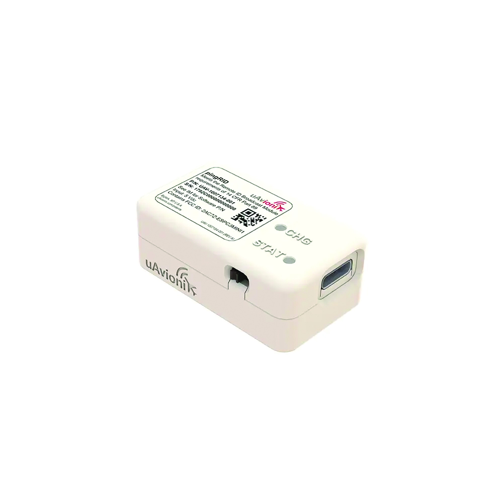
Remote ID Module
Meets FAA standards
The pingRID meets the Part 89 remote ID standards of the Federal Aviation Administration (FAA), which will become effective on Sept. 16, to keep operators safe and compliant throughout a flight. The pingRID comes pre-configured and ready for use out of the box. After assigning the pingRID unique identification number to the aircraft’s registration with the FAA, operators can attach the battery-powered device to their UAV and prepare for flight. A set of LED indicators provides status on the battery charge, device readiness for flight and inflight operations. The compact, lightweight design fits most aircraft without significantly impacting performance. The module also can be quickly recharged via USB-C. The FAA’s final rule on remote ID requires all UAV pilots to meet the operating requirements of Part 89. For most operators, this will require flying a UAV equipped with standard remote ID, a remote ID broadcast module such as the pingRID, or flying at a Federally Recognized Identification Area. uAvionix, uavionix.com
MOBILE
Image: Orolia
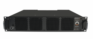
GNSS Simulator A positioning, navigation and timing test solution
GSG-7 delivers GNSS signal testing for location-aware applications and systems that require navigation or timing. The GSG-7 GNSS simulator features high-end performance with a 1,000 Hz simulation iteration rate, high dynamics, real-time synchronization, and simulation of all-in-view satellite signals. The GNSS simulator is suitable for development and integration projects that require high performance and an increased number of constellation licenses and satellites in view for a single antenna or trajectory. GSG-7 supports multi-constellation and multi-frequency GNSS simulations. It can be programmed to simulate operations with all current and future GNSS signals. Orolia, safran-navigation-timing.com
Image: Eos Positioning
GNSS Receiver Supports Galileo HAS
The Arrow Gold+ enables users to achieve better than 20 cm accuracy with 95% confidence using Galileo HAS. The Arrow Gold+ is one of the first high-accuracy GNSS receivers that supports Galileo HAS and is designed for the GIS market. Additional signal support for Arrow Gold+ includes: the concurrent use of the BeiDou B3 and GPS L5 signals as well as GLONASS, BeiDou, QZSS and IRNSS signals. Eos Positioning Systems, eos-gnss.com
Image: Pasternack
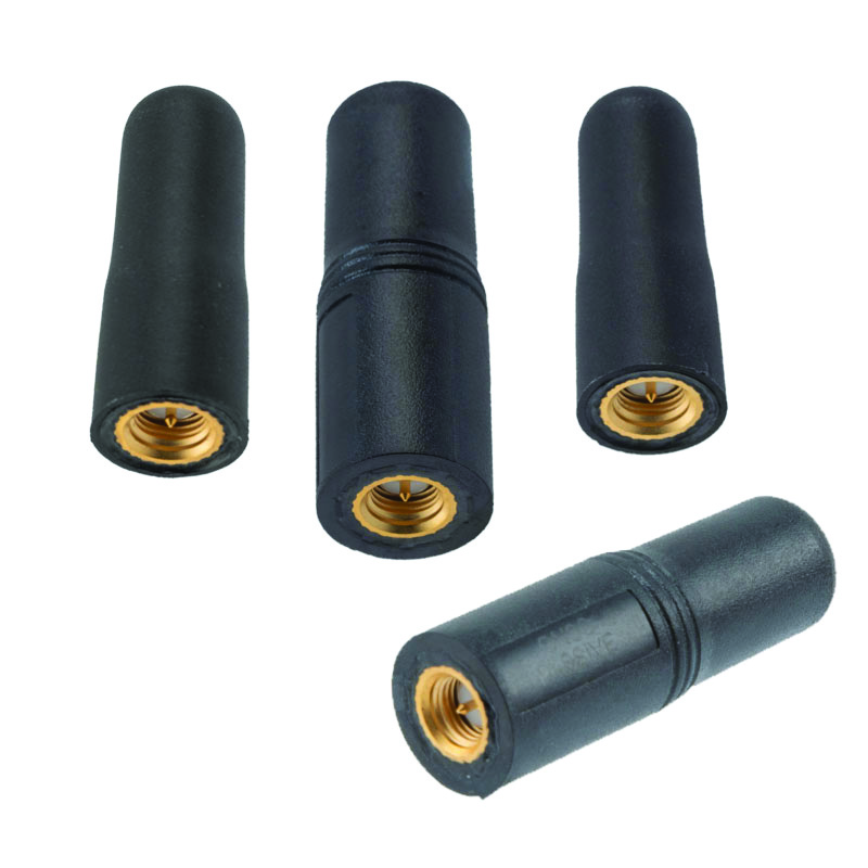
Mil-Spec GPS/GNSS Antennas Meets military specifications for use in several small form factor and mobile applications
The PEANGPS1006, PEANGPS1007, PEANGPS1008 and PEANGPS1009 mil-spec GNSS antennas are engineerered
for environmental performance according to the MIL-STD-810G standard and include multi-standard GPS L1, Galileo E1 and GLONASS options. They are IP67 rated and available in passive and active versions and provide coverage from 1,597 MHz to 1,607 MHz. The GNSS antennas feature linear polarization for cross-polarized isolation, nominal gain options of -3 dBic and 10 dBic, and SMA mounts. The mil-spec GNSS antennas are available now.
Pasternack, Pasternack.com
TFX62.A. (Image: Taoglas)
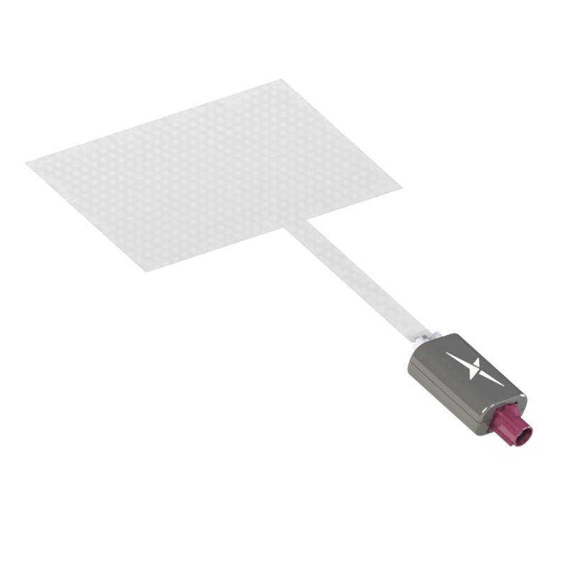
Near-Invisible Antennas Supports cellular Wi-Fi and GNSS technologies
The TFX62.A, TFX257.A and TFX125.A offer an alternative to standard opaque antennas, with “peel and stick” mounting capabilities to any nonmetal surface. The TFX62.A, TFX257.A and TFX125.A come with an adhesive and have an enclosed carrier terminated with a FAKRA connector for easy installation. The TFX series antennas leverage a sub-millimeter thick hybrid transparent conductive film that offers designers an invisible antenna solution. They are suitable for mobility, public infrastructure, medical devices, transportation and emerging IoT applications. Use cases for the antennas include electric vehicle chargers and parking meters, smart buildings and transportation vehicles.
Taoglas, taoglas.com
Image: CHC Navigation
3D Grade Control System For motor graders
The TG63 comes with a tightly coupled dual-GNSS positioning system and inertial sensor, and provides reliable 3D positioning and heading to ensure accuracy of the grader blade within ±2 cm. The TG63 is designed to withstand the harsh environment of construction sites and supports multiple applications, including real-time kinematic networked transport of RTCM via internet protocol and ultra-high frequency base stations.
CHC Navigation, chcnav.com
OEM
Image: ComNav Technology
GNSS Modules Now compatible with Galileo HAS
K8 series GNSS modules can use the Galileo High Accuracy Service (HAS) precise-point positioning (PPP). The PVT algorithm upgrade to the K8 series module supports Galileo HAS with an accuracy of 20 cm horizontally and 40 cm vertically. Galileo HAS provides free access to information necessary to estimate accurate positioning using a PPP algorithm in real-time through the Galileo signal E6-B and an internet connection. The improved performance capabilities provide a higher level of accuracy for industries such as UAV, autonomous driving, intelligent transportation, agriculture and more. ComNav Technology, comnavtech.com
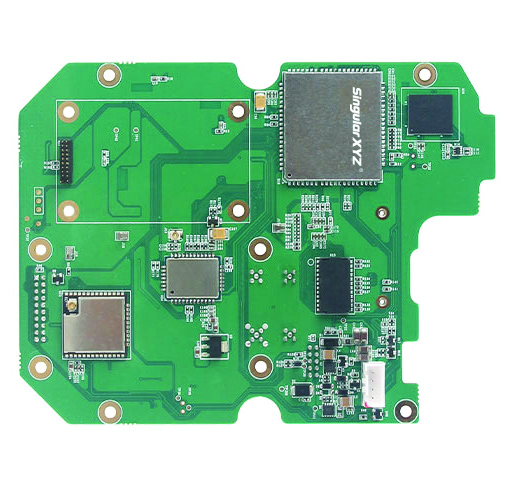
Images: SingularXYZ
Development Kit Designed for GNSS-related development integration
The DK100 development kit is a multi-functional kit with selectable single-antenna and dual-antenna modules, full constellation tracking and centimeter-level positioning. It is a ready-to-use kit designed to simplify integration efforts and increase compatibility with a variety of applications. The DK100 reserves standard adapter board interfaces to connect different GNSS modules and radio modules to meet specific needs. The development kits are coupled with a 4G module, Wi-Fi, Bluetooth, Ethernet modules, large memory and status indicators on a single PCBA. The DK100 comes with a web page for easy configuration. With Ethernet and Wi-Fi access, users can monitor device status and configure working mode and data transmission settings on the web page. The centimeter-level DK100 can be integrated in a range of horizontal and vertical applications, such as CORS construction, precision agriculture, construction machinery, smart navigation, monitoring, robotics, unmanned systems and more. Singular XYZ, singularxyz.com
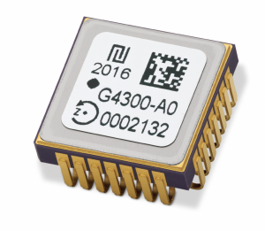
Image: TDK Corporation
Digital MEMS Gyroscope A high stability and vibration-tolerant gyroscope for dynamic applications
The GYPRO4300 features a ±300°/s input measurement range, 200 Hz bandwidth, and 1 ms latency with a closed-loop architecture that enables high linearity and stability. The GYPRO4300 has bias instability of 0.5°/h as a typical value and a maximum value of 2°/h. The GYPRO4300 is suitable for applications such as railways, land vehicles, vertical take-off and landing aircraft and UAVs, marine and subsea systems, borehole drilling and surveying instruments. The GYPRO4300 is available now for sampling and customer evaluations. Evaluations of the sensors also can be made with an Arduino-based evaluation kit that provides built-in testing functionalities such as output reading and recording, recalibration and digital self-tests. TDK Corporation, tdk.com
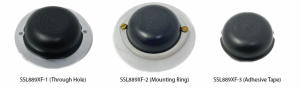
Image: Tallysman Wireless
GNSS Antenna Small, light, and dual-band
The SSL889XF employs Tallysman’s Accutenna technology providing GPS, QZSS L1/L2, GLONASS G1/G2/G3, Galileo E1/E5b, and BeiDou B1/B2b coverage. The SSL889XF antenna is designed for precision dual-frequency positioning where a light weight and a low profile are important. The SSL889XF antenna element is 48 mm in diameter and 20 mm tall and weighs ~50 g. It has a tight average phase center variation of less than 10 mm for all frequencies and overall azimuths and elevation angles. The SSL889XF is available in three versions. Model SSL889XF-1 has an integrated 61 mm ground plane and two mounting holes. Model SSL889XF-2 has a mounting collar, and model SSL889XF-3 is the antenna only and is attached using adhesive tape. All models have a female MCX connector. The SSL889XF antenna also supports Tallysman’s eXtended Filtering (XF) technology. Tallysman Wireless, tallysman.com
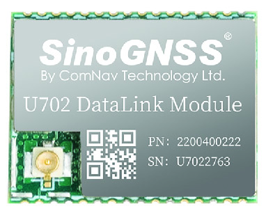
Image: ComNav Technology
Datalink Module Suitable for GNSS-based systems
The U702 datalink module is a RX/TX data link module that supports the LoRa modulation technique. Its compact, surface-mounted design and robust electromagnetic compatibility enable easy integration into GNSS systems such as robotic lawn mowers. With the LoRa modulation technique, the U702 has low power consumption, reception power of 0.025 w, and a working distance up to 1.5 km. It also enhances the ability to protect GNSS systems against various interference — making it possible to have high reception sensitivity, a low error rate, and high reliable data transmission even in harsh environments.
ComNav Technology, comnavtech.com
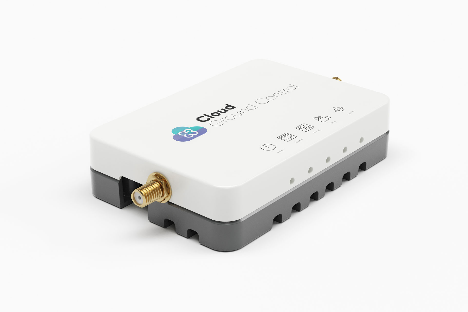
Image: Cloud Ground Control/Advanced Navigation
Fleet management device For air, land and sea vehicles
CGConnect can securely connect UAVs and vehicles into one autonomous fleet across land, sea and air, regardless of manufacturer or model. This provides mission planners and operators with full situational awareness for search and rescue, emergency response and disaster relief. Artificial intelligence (AI) algorithms are running in the cloud, relaying real-time camera feed data to the end user to support missions such as object detection, tracking and thermal imaging. The flexible and customizable open platform is operating on industry standards, which multiplies potential product applications and enables diverse autonomous vehicles and payloads to operate as a coordinated fleet. High-grade security safeguards data and IP from vulnerabilities and security breaches, helping users meet compliance obligations. Additionally, CGConnect supports edge AI to perform intensive object identification and classification directly on the vehicle for dynamic missions. CGConnect is available for pre-order. An OEM option is available. Cloud Ground Control/Advanced Navigation, cloudgroundcontrol.com/advancednavigation.com
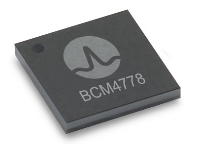
The BCM4778’s third-generation dual-frequency GNSS receiver features advanced multipath mitigation, L5 acquisition capability, LTE filtering and jamming protection
Broadcom Inc. has launched the BCM4778, its lowest power L1/L5 GNSS receiver chip optimized for mobile and wearable applications. Equipped with the latest GNSS innovations, the third-generation chip is 35% smaller and consumes five times less power than the previous generation.
Broadcom will be presenting further information on the chip in the Session B5, Panel: GNSS Chipset Technology – Trends, Opportunities and Challenges panel at the ION GNSS+ 2021 on Sept. 24.
Dual-frequency GNSS continues to be an important location feature for modern mobile and wearable devices, providing greater positioning accuracy for location-based applications. The advanced L5 signal enables sidewalk-level accuracy for pedestrian navigation in urban environments, as well as lane-level accuracy for vehicle navigation.
Reduction in GNSS power consumption is crucial to extending the battery life of a mobile or wearable device. Compared to GNSS receivers used in integrated platforms, Broadcom’s single-chip BCM4778 delivers significantly lower power consumption and higher performance while offering more advanced GNSS features, such as the next-generation Grid Tracking urban multipath mitigation technology.
“We are excited to see this impressive power reduction, combined with the L5 Grid Tracking technology in the new Broadcom GNSS chip. This will increase the impact of Google’s 3DMA ray-tracing for urban multipath mitigation,” said Frank van Diggelen, principal software engineer at Google.
Longer battery life. The BCM4778 increases the GNSS always-on battery life on a smartwatch by 30 hours compared to the previous generation chip operating on a 300-mAh battery. The extended battery life helps drive new experiences in smartwatches and phones, including keeping the GNSS always-on for fitness applications for multiple days on a single battery charge.
In addition, the BCM4778 features fully integrated LNAs for L1 and L5 bands, which reduces RF front-end BOM costs and footprint requirements, suitable for space-constrained applications. The chip offers increased flexibility to smartwatch and phone designers with its small size. Having the ability to place the BCM4778 closer to the antenna helps improve signal reception and enhances overall GNSS performance.
The BCM4778 dual-frequency chip is designed for small mobile and wearables. (Photo: Broadcom)
Product Highlights
7nm CMOS technology
Typical power consumption
4mW L1 band only
6mW L1+L5 simultaneous
FCBGA package
New Grid Tracking technology
Advanced multipath mitigation
Continuously tracks the full L5 channel
Capable of L5 acquisition
Increased processing capability and throughput
Advanced LTE filtering and jamming mitigation
Enhanced LTE Band 13 and Band 14 filtering
Spoofing and jamming detector
Jamming mitigation through multiband and multi constellation
Reduced BOM cost and footprint
Flexibility in using internal LNAs
Optional operation without interstage SAW filters
Integrated switching regulator with direct connect to battery
“With the launch of this third generation dual-frequency GNSS receiver chip, Broadcom continues the tradition of raising the bar for mobile GNSS,” said Vijay Nagarajan, vice president of marketing for the Wireless Communications and Connectivity Division at Broadcom. “Always-on dual frequency GNSS is a key request from mobile and wearable OEMs, and we are thrilled to deliver it.”
“Consumer electronic companies have been faced with the challenge of managing power consumption versus performance, often having to choose one over the other. Broadcom’s innovative approach to the BCM4778 allows their customers to realize improvements on both fronts,” said Ramon T. Llamas, research director for mobile devices at IDC. “The result: device manufacturers can enable new experiences and run applications over a sustained period of time. In addition, by reducing its BOM cost and its physical footprint, Broadcom is enabling further benefits from cost savings and design configurability.”
Broadcom is currently sampling the BCM4778 to its early access partners and customers. Please contact your local Broadcom sales representative for samples and pricing.
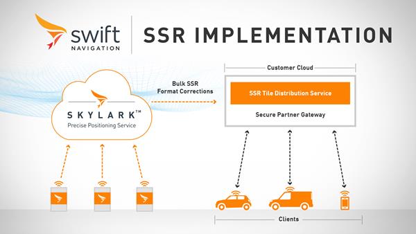
Swift Navigation has launched its production-grade SSR (state space representation) service across Swift’s coverage areas.
Swift is a San Francisco-based tech firm offering GNSS and precise positioning technology for mass-market applications in autonomous vehicles, mobile and internet of things (IoT).
SSR is a bandwidth-efficient format to deliver GNSS corrections to mass-market applications, such as for automotive and mobile customers. It is offered through Swift’s Skylark precise positioning service.
As a new option for corrections delivery available as part of Swift’s precise positioning service, SSR delivers seamless and homogeneous accuracy throughout a coverage area. To date, Skylark delivered corrections in OSR (observation state representation) format for compatibility with legacy equipment but with the introduction of SSR, the power of Swift’s cloud error modeling is now available in its native format.
SSR provides users with fine-grained information about GNSS error sources. SSR divides the coverage region into a series of “tiles” which can be broadcast to all users within that tile, enhancing scalability and minimizing bandwidth while maintaining the utmost security and privacy.
With the capacity to reach millions of connected devices in markets such as mobile and automotive, it is critical to provide both a scalable and secure solution. Swift’s Skylark can deliver bulk corrections data to enterprise customers’ backend for distribution, putting the customer in control of their own users’ privacy and security.
Swift’s enterprise-reference architecture code equips customers with the SSR Tile Distribution Server software that provides a seamless integration path to incorporate SSR corrections into their own cloud or on-premise solution.
Swift’s SSR solution is also based on the open standard from 3GPP. The significance of utilizing the SSR positioning standard from the 3GPP standards body is that it meets the interoperability requirements demanded by mass-market mobile and automotive applications.
“The team at Swift is excited to bring its production-grade, standards-based SSR service to market,” shares Fergus Noble, CTO at Swift Navigation. “The ability to deploy SSR to users in a scalable way, while maintaining privacy, makes it possible for automotive, cellular and IoT mass-market customers to integrate precise positioning into their service offering.”
Skylark is available for integration into wide-area, high-precision positioning applications across the continental United States and Europe and is available in the countries of Japan, South Korea and Australia, with plans to expand globally. Skylark is an ever-expanding service and is scalable to service millions of users. All eligible Skylark subscribers begin with a free trial or pilot program.
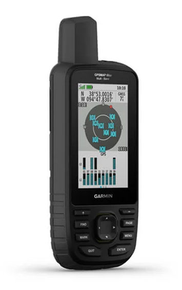
Garmin has debuted the GPSMAP 65, 65s and 66sr, three new portable devices with improved technology, precision and connectivity. GPSMAP is the company’s line of premium outdoor navigation units.
The GPSMAP 65, 65s and 66sr offer multiband technology for positioning and tracking anywhere. They are the first Garmin portable devices to receive and use multiple satellite navigation frequencies.
The multi-band technology and expanded GNSS support with addition of the L5 frequency (GPS, GLONASS, Galileo, QZSS and IRNSS) allows for reduced estimated position error, giving users improved accuracy and awareness of their surroundings.
The new models include TopoActive maps of Europe, smartphone notifications, color screens, battery improvement, compatibility with the Garmin Explore app and more. All three are rugged, dust, shock and water resistant (IPX71 rated).
“We are excited to grow our popular lineup of GPSMAP handhelds and introduce multiple GPS frequencies into the series,” said Dan Bartel, Garmin vice president of global consumer sales. “We’ve expanded our satellite support so you can explore with confidence, no matter where you go or what the conditions are.”
GPSMAP 66sr
The premium version, GPSMAP 66sr, has a 3-inch color screen readable in all lighting conditions and is compatible with night-vision goggles. In addition, it has been designed to military standards for thermal performance and resistance to shock and water (MIL-STD-810G), and includes a built-in S.O.S. LED flashlight for assistance. To give the user even more confidence, incorporates ABC sensors (3-axis electronic compass), accelerometer and barometric altimeter), allowing users to obtain the most accurate data available at all times.
GPSMAP 66sr also provides global forecasts and weather through the Active Weather feature, updated through wireless connectivity via Bluetooth and ANT +. Via the Wi-Fi connection, users can download satellite maps.
How will wireless technologies most significantly drive change and innovation in the surveying industry?
Miguel Amor
“GNSS by design, by physics, will always be challenged in urban settings. 5G and GNSS will provide a step to ubiquitous positioning in built-up areas — a blend of relative and absolute positioning, terrestrial and satellite-based measurements.” Miguel Amor Hexagon Positioning Intelligence
Greg Turetzky
“The improvements in bandwidth and latency of 5G will create new opportunities for edge and cloud-based computing advances such as AI and machine learning to penetrate surveying, as 5G is doing in other industries, to improve efficiency, accuracy and automation.” Greg Turetzky Consultant
Members of the EAB
Tony Agresta Nearmap
Miguel Amor Hexagon Positioning Intelligence
Thibault Bonnevie SBG Systems
Alison Brown NAVSYS Corporation
Ismael Colomina GeoNumerics
Clem Driscoll C.J. Driscoll & Associates
John Fischer Orolia
Ellen Hall Spirent Federal Systems
Jules McNeff Overlook Systems Technologies, Inc.
Terry Moore University of Nottingham
Bradford W. Parkinson Stanford Center for Position, Navigation and Time
The cellular 5G standard targets latencies under 1 millisecond, data rates of up to 10 gigabits per second, extremely high network reliability and better accuracy in positioning. With location awareness becoming an essential feature in many new markets, positioning is considered as an integral part of the system design of upcoming 5G mobile networks.
The cellular industry is currently implementing Long-Term Evolution (LTE)-Advanced, which might be called “4G” mobile broadband. Simultaneously, the industry is preparing the next step, a fifth-generation (5G) system. It will process communication 10 times faster than 4G, according to experts. 5G rollout will be complete in many international metropolitan areas by 2020.
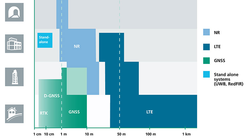
Positioning Performance for 5G NR and other technologies in different environments. (Image: Fraunhofer IIS)
Adaptive array antennas
In addition to the precise positioning it will afford, 5G shares another characteristic with GPS/GNSS: adaptive array antennas for digital beamforming (DBF). Adaptive arrays have many advantages for PNT, primarily in mitigation for multipath, jamming and spoofing.
Emerging applications of DBF in 5G involve dense networks of picocells, small cellular base stations that typically cover a small indoor area. Picocells extend coverage where outdoor signals do not reach well, and add network capacity in areas with very dense phone usage. 5G architectures will use adaptive array technology to achieve high data rates, spectrum reuse and communications robustness.
The implications for PNT are that 5G will require improved (relative) PNT to operate effectively, and picocells will be a source of PNT information in constrained environments.
5G involves massive directional communications via multiple-input, multiple-output (MIMO), enabling high-bandwidth communications in fading (multipath) channels by using multiple antenna inputs to adapt to channels. It can do this without knowledge of user location, but it adds to the processing complexity. The directional capability can enable multiple users to be serviced in a picocell at different frequencies, while permitting spectrum re-use by nearby picocells through narrow beamwidth and the limited range of millimeter-wave (mmWave) frequencies.
The PNT implications of 5G architectures, according to Gary McGraw of Rockwell Collins, are that 5G picocells will be synergistic with PNT in challenged environments — naturally, indoor and dense urban. They will necessitate development of distributed, networked PNT processing and infrastructure.
Fraunhofer
The 5G positioning framework will integrate a multitude of sensors into a hybrid positioning scheme, according to the Fraunhofer Institute for Integrated Circuits (IIS) in Germany. Fraunhofer IIS is currently prototyping low-latency and high-precision positioning systems for legacy LTE and future 5G New Radio (5G NR).
5G NR enables positioning by providing high bandwidths for precise timing, new frequency bands at mmWave, massive MIMO for accurate angle-of-arrival estimation and new architectural options that support positioning. Improved accuracy, robustness and latency can be achieved, according to the institute.
5G provides fast and reliable access to moving objects to achieve time-critical process control and optimization in industrial environments. Increased contextual awareness of goods, parts, machines and workers will enable new interaction and collaboration, the institute said.
Facebook’s Open Cellular group is developing a cost-effective, software-defined, wireless-access platform to improve connectivity in remote areas of the world, the company said.
The TW2643POC employs Tallysman’s Accutenna technology in a magnet mount, passive right-hand circularly polarized antenna for the reception of all of the GNSS constellations (GPS L1/GLONASS G1/ Galileo E1/ BeiDou B1) plus Iridum: 1559 to 1626.5 MHz frequency band.
According to Tallysman, it is certified and specially designed to maximize the performance of Iridium Voice and Data Modems plus the upper GNSS band (1559–1606 MHz).
The TW2643POC is housed in an IP67 compliant housing and is REACH and RoHS compliant.
Geographic data specialist Bluesky has secured funding from the United Kingdom’s innovation agency, Innovate UK, to investigate the potential of mobile phones for capturing accurate 3D spatial information.
Designed to reduce the costs of monitoring and managing essential infrastructure, such as overhead electricity cables, and mitigate the effects of potentially damaging vegetation, the Bluesky-led study will assess the feasibility of extracting 3D measurements from standard smartphone video footage.
Using specialist software and specially developed photogrammetric algorithms, it is possible to compute depth values for individual pixels within overlapping images taken from video to create dense 3D point clouds of an object or scene, Bluesky said.
Working in partnership with ADAS, an environmental consultancy, Bluesky will provide experience gained through previous data capture and management projects with electricity distribution network operator (DNO) companies in the UK and overseas.
The initial application of this innovative use of mainstream technology would be the accurate measurement of vegetation encroachment in the field for maintenance purposes. The company will also explore other applications of the solution in sectors such as forensics, insurance and emergency response.
World Market
DNO companies spend millions monitoring and maintaining clearance between trees and power lines, with the market potential in Europe alone estimated at £10 million per annum.
By using readily available mobile phone technology, Bluesky hopes to reduce this cost of overhead networks, both power and telecommunications, across the world, and provide managers with an easy-to-use and easy-to-update efficient audit trail.
Mobile World Congress, the world’s largest gathering for the mobile industry, will be held Feb. 27 to March 2 in Barcelona, Spain. Zack Weisfeld, Microsoft Ventures; Harper Reed, Paypal; and Reed Hastings, CEO and founder, Netflix, are delivering keynote addresses at the event, which last year had record attendance with visitors from 204 countries.
Organized by the GSM Association (GSMA), Mobile World Congress brings together mobile operators, including handset and device makers, software companies, equipment providers and internet companies, as well as organizations in adjacent industry sectors.