Mitch Narins, principal consultant & owner, Strategic Synergies LLC
Recently there have been conversations within the world’s position, navigation and timing communities regarding the use of the term “Gold Standard.” Many systems aspire to be a Gold Standard, but what does this mean and how should one rightfully claim this meritorious distinction? For me, to be called a Gold Standard, a system must meet a number of hard and soft performance requirements that instill users with trust and confidence. What are these performance metrics., and how should we measure them?
I propose that for a PNT system to be a Gold Standard, it must embody and embrace three basic operational aspects in its vision, mission and goals, which drive its design, development and operation:
Requirements. First, a PNT Gold Standard system must have clear, concise, published and independent operational requirements, established through recognized and appropriate standards — that is, the PNT “promises” of accuracy, availability, integrity, continuity and coverage provided by the system are available to all users, and any changes to these “performance requirements” are communicated and implemented in a formal and transparent process.
Monitoring. Next, a PNT Gold Standard must continuously monitor the system “health” to ensure that it is meeting all of its promised requirements (accuracy, availability, integrity, continuity and coverage). The measurements and monitoring information must be available to all users so they can, with confidence, independently verify performance in support of their missions and needs.
Transparency. Finally, and most importantly, a PNT Gold Standard must not only maintain transparency during normal operations, but at the most crucial times when the PNT system is not meeting its promised performance. When “things go wrong,” user communications and constant, continuous, and reliable information flows are essential to retaining trust (that is, the measure of the system operator’s integrity). “We don’t know what happened yet, but we will let you know as soon as we do” is acceptable; saying “no comment” is not. As soon as the cause of the problem is known, it must be promptly shared, in detail, along with the schedule for restoration of normal operations. All changes that will be implemented to preclude such an occurrence in the future and all lessons learned must also be communicated openly and honestly to users.
So, what is a PNT Gold Standard? It is a system that makes operational promises based on known and controlled standards and requirements and openly shares how performance against those promises is being monitored and assured. It is a system defined by mission, values, standards and operating principles that is committed to free and open communications when promised performance is being met and when it is not. It is a system that transparently documents, communicates, investigates and reports health and status to users without delay. It is a combination of known, measured and exceptional performance provided by a system operated with open, honest, inclusive, transparent and complete communications that evoke user trust. For me, that is what it means to be a PNT Gold Standard.
The European Space Agency (ESA) has launched a call for proposals to demonstrate the capabilities of new 5G cellular networks to support positioning and timing applications to complement satellite navigation.
5G will bring higher speed, larger traffic capacity and ultra low-latency (or signal delay) communications. 5G will also usher in a range of new possibilities for positioning, navigation and timing (PNT).
ESA is inviting proposals to implement pilot projects to demonstrate the viability of 5G PNT solutions in a number of use cases:
Indoor PNT for Industry 4.0, as needed to support the operations of smart warehouses and factories or smart city applications requiring transition from indoor to outdoor environments.
Outdoor applications where a robust back-up to satellite navigation is essential to meet safety requirements, such as autonomous driving or drone navigation.
Applications where robust time and frequency synchronization is necessary, both in outdoor as well as indoor environments, like smart energy grids or the 5G networks themselves.
5G networks will allow new types of measurements made possible by advanced antennas and by new positioning signals at higher frequencies, at both base stations and the user receivers. 5G networks will also bring enhanced connectivity to improve cloud-based positioning applications and value-added services.
While satellite navigation works optimally in outdoor environments with a wide view of the sky, 5G PNT has the potential to bring PNT to deep urban canyons in high-rise city centers and indoor warehouses, wherever 5G networks are deployed.
The combination of satellite navigation and 5G brings the promise of high performance, secure and resilient PNT services, as well as a seamless application of PNT applications from outdoor to indoor environments and from rural to urban areas, ESA said.
This call for ideas is supported through ESA’s Navigation Innovation and Support Programme (NAVISP), working with European industry and academia to develop innovative navigation technology.
Webinar on PNT 5G
To support the call, an information webinar is being held on 21 October, in which the various PNT 5G use cases will be presented by key speakers from each sector. Details of the call and how to apply will also be presented by ESA.
A networking platform has also been established to allow webinar participants and general stakeholders interested in the call to get in touch and discuss possible cooperation. This platform will be kept open during the entire period of the call’s duration.
For more information on the call and the agenda of the webinar visit ESA’s NAVISP website.
To register for the webinar and the networking platform, click here.
The United Kingdom will explore new options for satellite navigation and timing capability to support critical infrastructure, it announced in a press release.
The Space-Based Positioning Navigation and Timing Programme (SBPP) will explore new and alternative ways to deliver vital satellite navigation services to the U.K. for transport systems, energy networks, mobile communications, and national security and defense.
The SBPP also aims to boost the British space industry and develop the U.K.’s own capabilities in these services.
UK GNSS program reinvented
The new program follows the work of the UK GNSS program, which concludes Sept. 30. UK GNSS began in 2018 as a result of Brexit and the U.K.’s departure from the Galileo program.
UK GNSS is an exploration programme that has developed outline plans for a conventional satellite system as an alternative to American GPS or the EU’s Galileo. The program will now be reset as the SBPP to build on this work to consider newer, more innovative ideas of delivering global satnav and secure satellite services to meet public, government and industry needs.
In 2018, the government announced an 18-month program, led by the UK Space Agency, to develop a conventional GNSS, which could meet U.K. security requirements and support the U.K.’s sovereign space and cryptography sectors.
Work completed by the UK GNSS Programme so far has developed cutting-edge British expertise in areas such as spacecraft and antenna design, satellite and ground control systems, systems engineering and simulation, which have wider applications across the space sector, in addition to supporting specialist U.K. jobs and industrial GNSS capability.
The refocused SBPP program could include technology that supports people’s everyday lives, such as emergency services to locate incidents, financial services companies to regulate exchanges on the U.K. stock market, or energy networks to ensure households receive power. Satellite navigation systems are also necessary to unlocking future technologies such as driverless cars, smart cities and artificial intelligence.
Capitalizing on the ingenuity of British businesses and academics, the program will explore the use of different kinds of satellites at various levels of orbit by exploiting technologies offered by companies at the cutting-edge of innovation such as OneWeb, Inmarsat and Airbus.
A Cabinet Office Study examining the need for a U.K. space-based system for secure positioning, navigation and timing concluded that any solution would need to examine more options and further work is needed to determine what form a potential system takes so it provides value for money.
To meet U.K. industry and government needs for resilient global navigation and timing while also providing value for money to the public, the new SBPP will consider collaboration with international allies to share satellite navigation services, costs and technology.
“Satellites underpin so many of the services that we all use every single day, from precise train timetables on our phones and satnavs in our cars,” said Business Secretary Alok Sharma. “Through our Space-Based Positioning Navigation and Timing Programme, we will draw on the strengths of the U.K.’s already thriving space industry to understand our requirements for a robust and secure satellite navigation system. This includes considering low-orbiting satellites that could deliver considerable benefits to people and businesses right across the U.K., while potentially reducing our dependency on foreign satellite systems.”
“I am delighted to see a further boost to the U.K.’s already thriving space industry,” said Scotland Office Minister Iain Stewart. “The U.K. government works closely with industry and academia to support the sector. We have high ambitions for the U.K. to be a global sector leader. The U.K. government is expanding its plans to understand requirements for a satellite navigation system. Satellite navigation provides the core services that we all use every day such as our mobile networks and is the key to unlocking further technical innovation in the future. This new programme will potentially pave the way for greater independence from foreign systems such as the United States’ GPS or the EU’s Galileo system which will allow greater opportunities for British businesses.”
“Our work to date has developed cutting-edge U.K. expertise in satellite navigation spacecraft, antenna design and control systems, while supporting high-skilled jobs,” Graham Turnock, CEO of the UK Space Agency said. “Now is the time to drive this work further to look into wider, more innovative ways of delivering this important national capability — to help protect our critical infrastructure and put the U.K. at the forefront of the development of new space technologies.”
Currently, the U.K. is entirely dependent on foreign systems for these critical navigation services. SBPP will enable to the U.K. to build on its thriving space industry, home to global players such as Inmarsat, Airbus, Surrey Satellites (SSTL) and others, to become a global leader in space navigation technologies, developing new opportunities for businesses in the U.K. and overseas and creating new highly skilled jobs.
The government has made clear its ambitions for the U.K. to become a globally competitive space power and is taking action through the newly established National Space Council, emerging National Space Strategy and the Integrated Review of Security, Defence, Development and Foreign Policy, to create the conditions for a strong, secure and innovative space sector that delivers for the British people.
A government-backed study from London Economics estimated that sustained disruption to existing satellite navigation capabilities would likely cost the U.K. economy £1 billion per day. Investment in space technology and services will enable the U.K. to build back better, unleashing the country’s global competitiveness and underpinning growth and high-skilled jobs.
News from the British government appears to be a part of the United Kingdom’s diversification away from primary reliance on GNSS for positioning, navigation and timing (PNT) services, and toward a more diverse set of sources.
The nation has previously undertaken establishment of a National Timing Centre for distribution of time from suites of atomic clocks and has long transmitted an eLoran timing signal from a government facility in Anthorn.
Thursday’s press release, titled “Government to explore new ways of delivering ‘sat nav’ for the U.K.,” reinforces the government’s commitment to space-based PNT, but not necessarily from GNSS.
OneWeb satellites
The announcement follows significant criticism in Parliament of the nation’s purchase of a 45% share of the bankrupt communications satellite company OneWeb, with the India’s Bharti Holdings having the majority stake. OneWeb had 74 of its planned 648 satellites in orbit when it declared insolvency. With new ownership and financing in place, it plans to resume operations and launch another 36 satellites in December.
Prime Minister Boris Johnson’s motivation for making the investment was to offset Britain’s post-Brexit exclusion from Europe’s Galileo system. The idea was that OneWeb assets in low earth orbit (LEO) could provide a global British PNT capability.
This concept faced political and technical opposition from the start. Many technologists in the U.K. and elsewhere doubted that the constellation could be easily adapted to provide sufficiently accurate PNT services. The doubts were so serious that the senior career civil servant responsible for signing the agreement to invest in OneWeb took the very unusual step of refusing to do so without written direction from the political appointee she worked for.
Before the OneWeb investment, the U.K. government had been studying establish of its own GNSS like America’s GPS and Europe’s Galileo. Sources say the required investment was much higher than the nation wanted to make and would provide little added capability beyond that available from extant systems.
According to Thursday’s press release, the UK GNSS effort was exploratory and will end this month. It will be “reset” as the Space-Based Positioning Navigation and Timing Programme (SBPP). This project “will explore new and alternative ways that could be used to deliver vital satellite navigation services to the United Kingdom which are critical for the functioning of transport systems, energy networks, mobile communications and national security and defence, whilst boosting the British space industry and developing the U.K.’s own capabilities in these services.”
While the press release is short on detail, it does mention satellites at low earth orbit and that “a wider range of options” will be examined. This could suggest redoubling efforts on getting PNT from OneWeb, and/or investing in regional PNT satellites.
Galileo again?
The press release also says SBPP will “consider collaboration with international allies to share satellite navigation services, costs and technology.” This may signal reengagement with Europe on involvement with Galileo.
Some observers have said that Brexit did not have to automatically mean that the U.K. was excluded from the Galileo project. European Union membership is not required for participation in the European Space Agency which is responsible for Galileo. Switzerland and Norway, for example, are not EU members, but are members of ESA and sit on its governing board.
The U.K. government has been very concerned with PNT and GNSS vulnerability since at last 2012 when large solar flares became part of its National Risk Register. In 2017 a London Economics Report found that a five-day GNSS disruption would cost the nation more than $1.3B per day.
This most recent announcement indicates that Britain is still intent on going its own way and diversifying PNT sources, while still acknowledging the ongoing importance of GNSS and keeping its options open with allies.
Dana Goward is president of the Resilient Navigation and Timing Foundation. He is the proprietor at Maritime Governance LLC. In August 2013, he retired from the federal Senior Executive Service, having served as the maritime navigation authority for the United States. As director of Marine Transportation Systems for the U.S. Coast Guard, he led 12 different navigation-related business lines budgeted at more than $1.3 billion per year. He has represented the U.S. at IMO, IALA, the UN anti-piracy working group and other international forums. A licensed helicopter and fixed-wing pilot, he has also served as a navigator at sea and is a retired Coast Guard Captain.
1960: ARPA launched Transit, the first satellite in what would become the world’s first GPS. (Photo: U.S. Army/DARPA)
Sixty-three years ago, on Friday, Oct. 4, 1957, the Space Age began — most everyone alive today is a progeny. The Soviet Union sent a shiny, metal, beach-ball-sized sphere into orbit. Sputnik beeped every second for 21 days before going silent. Its beeps were heard ’round the world. Using the Doppler effect, a listener could tell whether the tiny satellite was moving toward or away from them. Scientists pinpointed the satellite’s exact location by observing it in a single pass, and realized the reverse could also be true. A terrestrial observer’s unknown location could be derived from the known orbit of a single satellite. That idea turned into the first satellite navigation system.
In 1964, the Navy Navigation Satellite System (NNSS) became operational. The highly classified system called Transit was built to support the Polaris ballistic missile submarine fleet. It operated on a small constellation of less than five polar orbiting satellites. With so few satellites in orbit, it could take more than an hour to get a positional fix. Twenty-meter accuracy could be attained by using specially encrypted signals, but these were restricted to submarines. All other users of Transit could only achieve accuracy within 200 meters.
Accuracy was a challenge. The problem was solved the same way John Harrison’s chronometer solved it 300 years earlier, threading together the past and present. More accurate location required more precisely measuring time (see geospatial-solutions.com/from-the-great-pyramids-to-gis-gps/). The problem was solved by two Timation satellites launched in 1967 and 1969 to broadcast a time reference signal. Essentially, the Timation satellites were space-based chronometers.
Timation improved location accuracy, even though it took hours to achieve sub-meter precision. It proved a success, and as a result, in 1967, Transit became available for non-military users, such as surveyors. In fact, everyone today who has ever worked with a reference system is familiar with WGS 84, which was originally based on “Doppler surveying receivers” called georeceivers, referring to measurements from the Transit system. Transit was also known as NavSat as it became more broadly adopted for civilian purposes such as commercial shipping.
In 1973 the Department of Defense sought to combine the success of Transit (NNSS) and Timation into one satellite system, which evolved into the NavStar-Global Positioning System. The first launches began in 1978 and reached a full constellation of 24 GPS satellites in 1993. Since that time, Russia, Europe, China, India and Japan have all created their own constellations. All of those systems combined with GPS make up the global navigation satellite system (GNSS), which totals more than 120 satellites.
Recognizing GPS’s sustained success and positive global impact, in February 2019 the Queen Elizabeth Award for Engineering went to four of the primary developers of the GPS program for their contribution to the world. These four gentlemen are Engineering Stars. On Feb. 12 of this year, President Trump signed an Executive Order further acknowledging the value of position, navigation and timing (PNT) as the invisible infrastructure of modern society. And, on July 1, Capt. “Sully” Sullenberger addressed the Space-Based PNT Advisory Board, stating how GPS has become a universal part of every facet of our lives including financial transactions, transportation, agriculture, rescue operations, surveying and construction.
The GPS satellites are our own constellation and each of them should be named in honor of a scientist or engineer who helped conceive and develop the Transit, Timation and GPS programs; even though the earlier systems no longer exist, their legacy should long be remembered.
From those Cold War origins of a chirping beach ball traveling through space 63 years ago, now more than 2,600 satellites enhance our terrestrial lives providing better communication, location and understanding. We are all children of the stars, albeit stars of our own making.
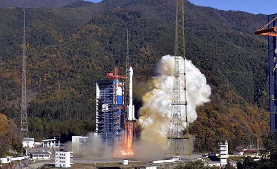
Recent completion of China’s BeiDou satellite navigation system has rekindled privacy and security concerns among some in the West. China has incorporated a two-way messaging capability into BeiDou that many fear will be used to track individuals and install malware on user devices.
Most satellite navigation experts view such concerns as far overblown.
At the same time, though little discussed, BeiDou’s completion does signal a new phase for China’s status as a world power and its ability to challenge the West on many fronts.
Two-way communications
It is possible for specially equipped receivers to communicate back to the BeiDou constellation. But this is not true for the vast majority of receivers (including those in cell phones). Industry experts say that all mass market chips for every GNSS system, including BeiDou, are “receive only.” Only specially equipped devices will be able to take advantage of its two-way communications capability, and it should be quite apparent to users when it is in operation.
Users, they say, should be much more concerned about location privacy and security issues that have been around for decades. Mobile phones have long reported user locations through the cellular network based upon information derived from GPS, WiFi ranging and other position calculations. The ability to hack and compromise a cell phone or other receiver will not be affected by the addition of BeiDou as a receive-only location source.
It is also important to note that using specialized equipment for two-way communication with a Global Satellite Navigation System (GNSS) is not something new to BeiDou. While the Chinese system may have improved upon the capability, users with the right equipment can send messages using the Search and Rescue functions to the United States’ GPS, Europe’s Galileo, and Russia’s GLONASS.
China has risen
Completion of BeiDou, unquestionably a significant technical achievement, does signal a significant step up for Chin’s status as a world power and influencer. It is a declaration of technical independence from the West with wide ranging geo-political impacts.
“(1) address national security requirements by ending military reliance on GPS;
(2) build a commercial downstream satellite navigation industry to take advantage of the quickly expanding market; and
(3) achieve domestic and international prestige by fielding one of only four such global navigation satellite systems (GNSS) yet developed”
Military Power and National Security. The Chinese military has long sought its own GNSS. This was amplified during a crisis in 1996 when it fired three missiles toward Taiwan as a warning. One struck the sea about 11 miles from a Taiwanese military base, but the other two disappeared. China claims that the United States interfered with GPS signals and was to blame. The Chinese military was both horrified and humiliated.
Having a sovereign GNSS eliminates the problem of relying on the U.S., Russia, or Europe for satellite navigation. That it is the world’s newest system also certainly has its advantages. China has undoubtedly incorporated state of the art anti-jamming and anti-spoofing capabilities into the version of BeiDou used by the military. After decades of observing others interfering with GNSS signals, and doing a fair bit of it on their own, it would be hard to imagine Chinese engineers not including the latest resilience features.
An operational BeiDou also means that China’s military is much freer to interfere with GPS and other GNSS in pursuit of tactical and strategic advantage without endangering its own services and infrastructure. It is likely that the levels of jamming and spoofing seen near the Spratley Islands and mainland ports will increase. Even if they do not, the increased possibility of Chinese interference will add yet another degree of complexity and uncertainty for western military forces.
Economic Power. The technological and commercial benefits of BeiDou for China are unquestionably substantial as well. Direct benefit from the manufacture and sale of equipment, plus spinoff industries and technologies, add to an already impressive national technology and economic portfolio. This is especially true since positioning, navigation, and timing (PNT) services are a “silent utility” underpinning so many network and other technological systems. The huge domestic market and robust overseas sales continue to grow (by 20% per annum according to Chinese reports) providing huge returns.
Prestige and Soft Power. “BeiDou launch marks China’s rise to ‘major space power’” read a recent headline in the Asia Times. This is perhaps understated as, with BeiDou complete, there is, technologically, little the West has achieved that China has not equaled. This has greatly enhanced China’s global standing and made it, in the eyes of many in the developing world, an ally and provider as good or better than the U.S. or Europe.
And China is eager to share its new PNT utility with others to further, not just its economy, but more importantly its long-term strategic interests.
Forsaking GPS
Regionally, China has been encouraging neighbors to adopt BeiDou for national PNT and forsake GPS. As one example it provided Thailand with nearly $300M in foreign aid targeted to promoting BeiDou use by Thai government organizations.
Writing in July in The Diplomat, Dr. Namrata Goswami observed
“… BeiDou is located within China’s ‘Information Silk Road,’ a subset of its land and maritime silk routes under the Belt and Road Initiative (BRI). China is now able to extend influence in a multidomain environment (land, sea and space) via its BeiDou space system, which provides navigation to aircraft, submarines, missiles, as well as commercial services dependent on such navigation. China’s Ministry of Industry and Information Technology sells the Information Silk Road, to include BeiDou and 5G networks, to global audiences as a completely self-sufficient technology infrastructure that anticipates life in the 21st century.”
This extends China’s influence through BeiDou even farther and has led a number of nations to seek closer ties with China through BeiDou.
Mohamed Ben Amor, secretary general of the Tunisia-based Arab Information and Communication Technology Organization, an organization of the Arab League, told GPSDaily.com, “Cooperation on the BDS is of special significance for the Belt and Road construction…The next step of the China-Arab cooperation is to achieve further connectivity and both sides can apply the BDS to promote regional technological and economic development.”
Iran’s view
Iran has had a Memorandum of Understanding with China about BeiDou since 2015. It provides for BeiDou ground stations in Iran, access for Iran to high-precision services, and establishment of an Iranian center for space data collection.
And In a tweet last week Iran’s Ambassador to China cited BeiDou’s completion as the “…end to the monopoly of the U.S.’s GPS.” He said, “There is great potential for aerospace cooperation with China,” and went on to suggest that Iranian aerospace students could work as a bridge between the two countries.
Similar comments have been published from entities in India, Indonesia, Malaysia, and throughout Southeast Asia.
China is indeed to be congratulated for a significant achievement with the completion of BeiDou. Even more noteworthy, though, is how it has integrated BeiDou seamlessly into its national plans for technology, economic, military and diplomatic efforts — a comprehensive, coordinated program to boost its standing in the world, especially relative to the United States and Europe.
Dana Goward is president of the Resilient Navigation and Timing Foundation. He is the proprietor at Maritime Governance LLC. In August 2013, he retired from the federal Senior Executive Service, having served as the maritime navigation authority for the United States. As director of Marine Transportation Systems for the U.S. Coast Guard, he led 12 different navigation-related business lines budgeted at more than $1.3 billion per year. He has represented the U.S. at IMO, IALA, the UN anti-piracy working group and other international forums. A licensed helicopter and fixed-wing pilot, he has also served as a navigator at sea and is a retired Coast Guard Captain.
New players are offering GNSS correction services — pushing prices down and offering new business models. What opportunities does this open up?
Jules McNeff
“This trend is encouraging, as new entrants bring energy and new ideas, keeping the PNT technology sector fresh. GNSS corrections enhance the value of dynamic mapping coupled with grid-coordinate systems such as the U.S. National Grid in producing user-friendly geolocation values for delivery of people and things and especially enabling efficient, precise, land mobility activities such as spatial awareness for autonomous vehicle movement and command and control of emergency response operations.” — Jules McNeff Overlook Systems Technologies
Greg Turetzky
“In a 5G world where most devices regardless of size are connected, it make sense that those devices that are mobile are going to need to be located. Correction services are key to providing enhanced accuracy, and new business models are needed to address these new markets that are fundamentally different than traditional high-accuracy markets.” — Greg Turetzky Consultant
Jean-Marie Sleewaegen
“Traditional correction services rely on bidirectional communication between a user and a local correction provider. They offer centimeter accuracy over small regions. Instead, new services broadcast corrections applicable to larger areas and with flexible accuracy levels, from centimeters to decimeters. They bring benefits not only in pricing, but also in terms of accessibility, scalability and ease of use. They make accuracy transparent to the user, opening up the opportunity of high accuracy to mass-market and industrial applications.” — Jean-Marie Sleewaegen Septentrio
The U.S. Department of Homeland Security “did exactly what was required by Congress” in issuing its report in June on positioning, navigation and timing (PNT), according to a letter sent by numerous PNT companies to the DHS.
The July 17 letter to Chad F. Wolf, acting secretary of Homeland Security, refutes a previous letter from Congressional representatives that the report contained numerous errors and failed to address many of the things Congress had required.
“We believe that some key claims made in the members’ letter of June 9 are either exaggerated, irrelevant to the report’s Congressional tasking, or simply wrong,” states the July 17 letter, which is signed by senior executives of Satelles, Orolia, Iridium, Navsys, Jackson Labs, Seven Solutions and Qulsar.
The group takes on the claims of the representatives point by point, finding them exaggerated, irrelevant or incorrect.
For instance, the letter critical of the DHS report states:
“The report focuses on the needs of ‘industry’ largely ignoring the needs and impacts on public services (including first responders), government operations, and individual citizens.”
In response, the industry representatives state:
“The focus of the report, as directed by the NDAA, is on the requirements of the owners and operators of national critical infrastructure. This includes “public services, government operations,” and its beneficiaries, “individual citizens.” To the extent that the report focuses on incentivizing the industry, it is in order for it to be able to meet these requirements.
“While the report only highlights PNT use cases from a subset of the 16 critical infrastructure sectors, their pragmatic recommendations address a range of requirements across all sectors. With respect to PNT needs for backing up GPS, DHS acknowledges the differences between and commonalities among the sectors and offers exceptional guidance for leveraging the capabilities of diverse forms of commercially available alternative PNT rather than endorsing a single, anti-competitive, government-imposed solution.”
Not just supporting players, alternative positioning, navigation and timing (PNT) systems strengthen, augment and — when needed — replace GNSS. GPS World explores how companies are using alternative PNT, and talks with John Fischer of Orolia about the company’s latest developments.
GPS World: What are Orolia’s latest advances and products regarding alternative PNT?
John Fischer: Regarding timing, which we have been doing for decades, our big alternatives to GNSS are internal atomic clocks and network-based timing, such as precision time protocol (PTP). Regarding positioning and navigation, the two areas on which we focus are IMUs and getting updates from GNSS, so that, when you lose GNSS momentarily, you have something on which to coast. The breakthroughs in MEMS technologies are astounding —they are getting better and cheaper every day. That shows wonderful promise.
The other area is doing satellite navigation using low Earth orbit (LEO) satellites, which are much closer to the Earth than GNSS ones and give you 30 dB or more of signal strength. We are focused the most on the Satellite Time and Location (STL) signal because it is available today. Supplementing your navigation system with updates from LEO satellites provides you some great non-GNSS navigation capability.
GPS World: The positions of LEO satellites are not monitored as closely as those of GPS satellites. Is that an issue?
JF: That is correct. You are losing accuracy by using what is available today because you do not know the positions of those satellites as well as you know those of the GNSS satellites and maybe you do not have the best geometry. All the GNSS satellites are in medium Earth orbit (MEO) because they have much better geometries for a small constellation. With just 24 satellites in MEO orbit, you get great geometries. When you go lower, you need an increasingly greater number of satellites.
The first generation of LEO satellites, the Iridium STL, are a much larger constellation, with 66 satellites, but still not enough to give you the good geometries. Today, you are getting less accuracy, but there are all kinds of new satellites being launched and the capability to track them will improve. We expect to be able to use signals from hundreds, if not thousands, of LEO satellites, so the geometry problem will start to go away and there are other things we can do to improve the accuracy. Meanwhile, we can get rather good performance with what we have today.
GPS World: What are some of your most recent advances, releases or products?
JF: On the timing side we have what we call a mini-Rubidium, the mRO-50, which we launched on June 4. Smaller, better, cheaper atomic clocks are coming out very soon.
GPS World: Do you have any comments on the recent executive order on resilient PNT?
JF: We coined the term “resilient PNT,” so we are glad to see it in use. We fully support those efforts.
GPS World: What about other alternative sources of PNT data, such as radar, lidar and signals of opportunity?
JF: Yes, they are that next level. Loran is ideal because it is so different from GNSS. When you are trying to design a reliable system, you want a lot of diversity, because if two systems have the same kinds of failure modes you have not gained in redundancy. Loran is literally at the other end of the spectrum from GNSS: It is a low-frequency microwave system. Instead of being space-based, it is land-based; instead of being low power, it is high power. However, there still are no stations up. It requires big equipment, so it will take some time.
When it comes to what you can do today, Loran does not contribute much. We support efforts to implement Loran very much, because we do need non-GNSS ways to make things resilient. Prior to GPS, we had to depend only on Loran. Today, with modern digital signal processing (DSP) techniques and receivers, I think we can expect the new Loran system to have much better accuracies than we had in the bad old days of the first generation of Loran.
The auto industry is doing a marvelous job of doing navigation using lidar or cameras. They are pretty much navigating driverless cars the way that humans drive, by just using visual cues. Those things have promise in certain unique areas.
On June 25, 1945, ION held its first organizational meeting on the Los Angeles Campus of the University of California.
According to ION, 55 people attended this meeting, where a “temporary” organization was established until a general meeting could take place in the fall when articles of incorporation could be drafted and adopted, council members elected and the vision for ION could begin to take shape.
The global impact of ION has been documented in its more than 2,600 technical papers that have been published in Navigation, the Journal of the Institute of Navigation. Navigation was first published in March 1946.
The Institute of Navigation is a non-profit professional organization advancing the art and science of positioning, navigation and timing.
Orolia will host a second industry discussion on the positioning, navigation and timing (PNT) Executive Order, a federal initiative to protect critical infrastructure from GPS/GNSS jamming and spoofing threats, and other PNT service disruptions.
Speakers include:
John Pottle, Director, Royal Institute of Navigation
Greg Gerten, Director of PNT Operations, Centauri Corp.
Tyler Hohman, Director of Products, Orolia Defense and Security
The first Orolia PNT Coffee Talk, which focused on jamming and spoofing, is available here.
The second session — which takes place July 16, 2 p.m. EST — will explore the importance of vulnerability testing to protect critical infrastructure with Resilient PNT technologies. The defense industry has addressed complex GNSS and PNT threats longer than any other sector, and experts will share their insights and best practices to help inform the protection strategy for critical infrastructure identified in the Executive Order.
Vulnerability testing with GNSS simulation is essential to protect critical infrastructure. However, there is no one-size-fits-all approach. This testing requires the ability to customize scenarios per application. It also needs to identify gaps across a variety of unique and geographically distributed systems.
Test results provide the basis to select the best PNT technologies to increase resilience, while ongoing regular testing ensures that critical systems can adapt and overcome evolving threats.
The Orolia PNT Coffee Talk is for those interested in learning more and discussing the latest developments in this national priority from industry and government perspectives.
Orolia PNT Coffee Talk
Vulnerability Testing for Critical Infrastructure: Lessons Learned from Defense
NASA will be hosting the national space-based PNT advisory board meeting on July 1. The meeting will be held virtually, rather than in-person, 11 a.m. to 3 p.m. Eastern Time.
NASA sponsors the advisory board on behalf of the National Executive Committee for Space-Based PNT. Advisory board members are nominated by the agencies of the National Executive Committee and appointed by the NASA administrator.
According to NASA, this meeting will be formally called the “24th Interim Meeting” in preparation for the 25th meeting in the fall of 2020.
The meeting will cover a number of topics, including:
Updates on emerging U.S. PNT policies;
the status of GPS constellation services and modernization;
techniques to protect, toughen and augment to GPS/GNSS services for multiple user sectors;
alternative or complimentary PNT signals sources to GPS/GNSS signals in a stressed spectrum environment;
opportunities for enhancing the interoperability of GPS with other emerging international GNSS constellations; and
emerging trends and requirements for new PNT services in U.S. and international fora.
Those participating must use a touch-tone phone. Any interested person may dial the USA toll-free conference call number 1-844-467-4685 or toll number 1-720-259-7012, passcode 106724, to participate in this meeting by telephone.
For more information, contact James J. Miller, Designated Federal Officer, Human Exploration and Operations Mission Directorate, NASA Headquarters, Washington, DC 20546, (202) 358-4417, fax (202) 358-4297, or [email protected].