Orolia has launched the virtual Orolia Air Show, which will take place June 23-26. The free event aims to connect the global aviation industry.
“As the aviation industry is deeply impacted in daily operations and trade shows are on hold, Orolia is highlighting the importance of aviation technologies with this global event,” the company said.
Attendees will have the opportunity to catch up on the latest industry updates and compliance requirements in a series of one-hour sessions.
Session topics will include the next generation emergency locator transmitters for commercial airlines; combat search-and-rescue beacons to support critical military missions; advanced GNSS anti-jamming and spoofing solutions for commercial and military critical infrastructure; and timing and synchronization embedded systems.
Founded in 2006 and headquartered in France, Orolia provides resilient positioning, navigation and timing solutions.
Through the ION Online Job Board, ION corporate members can post job listings for free. For a limited time, non-ION corporate members can also post job listings for free. The job postings will expire automatically after 14, 30 or 60 days, depending on which expiration date the job poster chooses.
“To meet the burgeoning demand for a targeted talent pool specific to the PNT community, the new ION Online Job Board will help connect qualified job seekers with exciting and diverse employment opportunities for this niche audience, and in turn will help our corporate members continue to build talented teams to better ensure the success of their business,” said Lisa Beaty, executive director at ION.
The The Institute of Navigation is a not-for-profit professional organization dedicated to advancing the PNT industry.
The BroadSim Advanced GNSS Simulator (Photo: Orolia)
Orolia Defense & Security offers a range of solutions that support critical positioning, navigation and timing (PNT) systems for Navigation Warfare (NAVWAR) domains. Orolia is approved to work on the full spectrum of U.S. government classified and unclassified projects and is positioned to support strategic partnerships in the development of key positioning, navigation and timing (PNT) technologies for the defense market.
BroadSim Advanced GNSS Simulator. Powered by the Skydel software engine, BroadSim provides software-defined features and benefits, with additional capabilities and specifications for applications requiring maximum security and compliance. With 100+ units fielded, BroadSim is trusted by the U.S. government, military and industry.
Broadsim supports encrypted signals (Y-code, M-AES, and M-MNSA) and provides advanced jamming and spoofing simulation. Scalable configurations for testing CRPA/antenna electronics systems (anechoic and wavefront) are available. BroadSim has four independent RF outputs and runs on a custom Linux operating system.
Interference Detection & Mitigation (IDM). Orolia’s IDM technology is patented, rigorously tested and field proven for more than a decade, while regularly updated to conform to new and emerging threats. BroadShield provides embedded GPS jamming and spoofing detection, serving as a kill switch. BroadSense offers mobile detection for situational awareness, and ThreatBlocker provides protection with in-line detection and suppression.
Resilient PNT. Orolia’s resilient PNT solutions improve the reliability, performance and safety of customers’ mission-critical operations for air, land, sea and space applications.
The 8230 AJ GPS/GNSS anti-jam outdoor antenna is a high-gain (40-dB) GNSS outdoor antenna with a unique conical pattern that rejects interference from the horizon. IP67-rated, it is designed for harsh environments.
The VersaPNT provides a rugged and resilient PNT source. The all-in-one customizable system delivers accurate, software-configurable PNT signals and high-performance for mobile applications in GNSS-degraded and denied environments.
With the first GPS Block III satellite SVN 74 being set as healthy and active in January, GPS has reached another important milestone. Setting the vehicle healthy and active makes the satellite available for use by military and civilian GPS users around the world. GPS has been a hugely successful system, consistently exceeding its performance specification and providing users with levels of accuracy and availability that would have seemed astonishing only a few short years ago.
Despite these successes, the limitations of GPS and other GNSS have been highlighted by a catalog of real-world well-documented jamming and spoofing incidents, some of which have had serious impacts. With this increase of incidents, the military and commercial worlds have become increasingly aware of the vulnerabilities of sole reliance on GNSS. Interference with GNSS is a critical risk to not only business continuity, but to the safety of the world.
Image: Spirent Federal
Simply trusting the output from a GNSS receiver without question is no longer acceptable in safety- or liability-critical applications. The focus of many manufacturers and developers has been on assuring the integrity of reported GNSS PNT data.
Recently, more systems have begun using non-GNSS data sources to augment the GNSS solution. A GNSS receiver becomes one of the many sensors used in a system that combines their inputs to provide an assured, trustworthy source of precise positioning and timing data even when GNSS is disrupted. There are also active global initiatives in both commercial and military domains worldwide to seek and develop direct replacements for GNSS-based navigation and timing systems.These systems eliminate the use of GNSS completely and are termed “alternative navigation systems.”
Whether assured, augmented or alternative, these PNT systems need careful assessment. Their performance, robustness and resilience need to be measured in normal conditions and with interference.
Spirent is actively working to develop new, relevant test frameworks and designing the next generation of PNT test equipment that can easily integrate with and assess more than one technology. From inertial integrated with GPS to a number of alternative PNT systems that are being analyzed by the U.S. government, Spirent is working to unlock the maximum benefits of the next generation of PNT solutions.
Roger Hart, director of engineering, joined Spirent Federal in 2015. He has worked in development of spacecraft navigation systems, including GPS, for civil, NASA and defense applications since 1986. Guy Buesnel is Spirent’s specialist PNT Security Technologist covering the areas of PNT threats and mitigation.
The PNT Coffee Talk event will be held online and is open to those interested in learning more and discussing this national priority from the industry and government perspectives.
The Executive Order, issued Feb. 12, is a federal initiative to protect critical infrastructure from GPS/GNSS jamming and spoofing threats, and other disruptions to critical PNT services. These threats can deny access to, or compromise, essential PNT data that critical infrastructure needs to operate.
This initiative, titled “Executive Order on Strengthening National Resilience through Responsible Use of Positioning, Navigation and Timing Services,” includes the following critical infrastructure: defense, homeland security, transportation, power grids, communications/mobile, precision agriculture, weather forecasting and emergency response.
Key actions include assessing jamming, spoofing and other PNT disruption risks across these critical infrastructure programs, developing customized PNT profiles to address risks, and deploying Resilient PNT technology to increase resilience.
Survey seeks feedback. Orolia asks those interested to share questions and comments and let the company know what you’d like to discuss during this PNT Coffee Talk event through an anonymous survey.
Government officials, advisors and congressional staff gathered at NASA’s Langley Research Center on March 13. They were there to discuss the Department of Transportation’s (DoT’s) GPS Backup Technology Demonstration program and view the offerings of six different companies.
A second event to view and discuss technologies offered by the other five companies in the program is scheduled (as of this writing) for Friday, March 20, at Joint Base Cape Cod, Massachusetts.
View from Washington, D.C.
The day began with remarks by Karen Van Dyke from the U.S. Department of Transportation, as well as remarks prepared by Colonel Joseph Frankino, deputy director of the National Coordination Office, a multi-agency staff that supports the National Space-Based Positioning, Navigation, and Timing (PNT) Executive Committee, whose members were unable to attend.
Van Dyke provided an overview of the program and pointed out the increasing importance of resilient PNT. As just one example, improvements in autonomy and self-driving cars are entirely dependent upon consumers having confidence in the entire system, much of which is underpinned by PNT.
Col. Frankino’s remarks reflected the Defense Department’s commitment to and support of DoT’s resilient PNT efforts. He pointed out that the nation’s military depends upon the defense industrial base, which depends upon uninterrupted PNT.
Volpe Transportation Systems Center
The technology demonstration effort is being coordinated by Andrew Hansen from DoT’s Volpe Center. Dr. Hansen pointed out that the ongoing effort, the analysis and assessment of which is expected to be concluded in May, is a series of demonstrations vice tests. This means that the companies involved were showing what their systems could do, vice being measured against set criteria.
He also mentioned that the maturity of all the systems involved seems to have improved significantly over the last year. All are at Technical Readiness Level 6 or better. Also, that things so far had gone very smoothly with no need for any “re-dos.”
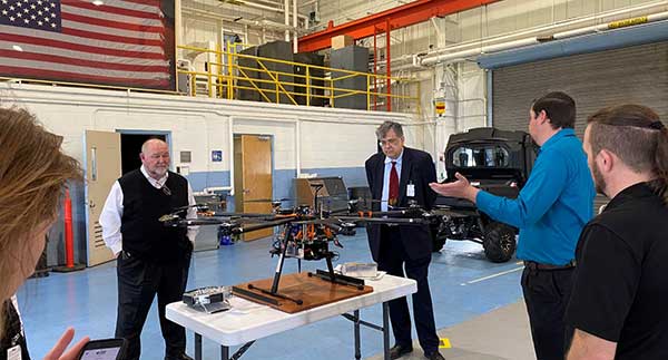
GPS and a cesium clock were being used as reference standards for the demos. Two of the systems, NextNav and Skyhook, were also demonstrated on a drone at Langley’s 150 acre open air site.
Report and Transparency
Data from the demos is not proprietary and belongs to the government which intends to make “as much of it available as possible.” DoT representatives mentioned several times their desire for maximum transparency.
Admiral (ret.) Thad Allen (left), chair of the National PNT Advisory Board, was among the attendees learning about DoT’s GPS Backup Technology Demonstration project at NASA’s Langley Research Center. (Photo: RNT Foundation)
Attendee Observations
After a day of viewing and discussing the six different technologies with their vendors, the group reconvened to offer feedback. All agreed the day was very worthwhile and complemented DoT and NASA on the event.
Kicking off the discussion, the DoT hosts remarked that the department is fully committed to GPS and its modernization. That said, there is broad recognition of the importance of other PNT systems. This is evidenced by the recent White House Executive Order on PNT.
Also, that there is no single solution that will fill the PNT needs of everyone. In fact, GPS does not serve the PNT needs of everyone. The need across sectors for a wide variety of sources to “backup” GPS is why the demonstration project includes some systems that only provide time, or only positioning.
Feedback from attendees included:
The reason for this project is that we have a 20th-century GPS and 21st-century threats. New technologies need to be examined for vulnerabilities. Security must be “baked in” from the beginning. Moderators commented that the DHS Conformance Framework was one of the tools that would help with this.
Rural and other underserved areas (such as wilderness, remote transportation networks, maritime) need PNT and should be a part of the government calculus.
Many systems depend upon infrastructure provided by others versus being self-sufficient.
In the view of many in Congress, it is good to see the demos going well. Overall, though, things are about two years late. Members and staff are very interested in when there will be an RFP and schedule for implementing the timing system mandated by the National Timing Resilience and Security Act of 2018.
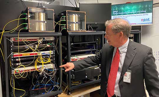
Monty Johnson of the company OPNT demonstrates precise time transfer through 100 kilometers of spooled fiber-optic cable. (Photo: RNT Foundation)
Systems Demonstrated at NASA Langley
During the course of the day, attendees had the opportunity to interact with representatives from the following companies and their systems.
Specifically, Booz Allen’s work will aid in the development and modernization of GPS systems through major programs such as Military GPS User Equipment (MGUE), GPS III and Next Generation Operational Control System (OCX).
The NIWC Pacific Positioning, Navigation, and Timing (PNT) Division is the Navy’s principal research and development center for navigation sensors and systems.
SMC is the center of technical excellence for developing, acquiring, fielding, and sustaining resilient and affordable military space systems.
With this contract, Booz Allen will continue to serve as a key mission partner for NIWC Pacific and SMC on the important endeavor of modernizing PNT systems for U.S. and Allied warfighters.
To execute this highly complex scope of work, Booz Allen will provide a range of essential services, including system definition, requirements synchronization, capability improvement, cybersecurity engineering, platform integration and testing, and acquisition program management.
“Booz Allen’s robust track record of work in both systems engineering and cybersecurity continues to inspire trust from our clients,” said Vice President Brian Zimmermann. “Our deep bench of leaders and technical experts reassures our clients that no project is too big or too complex. It’s our privilege to help the Navy and Air Force modernize GPS systems that are so vital to the security of our nation.”
Read more about Booz Allen’s work with PNT systems here.
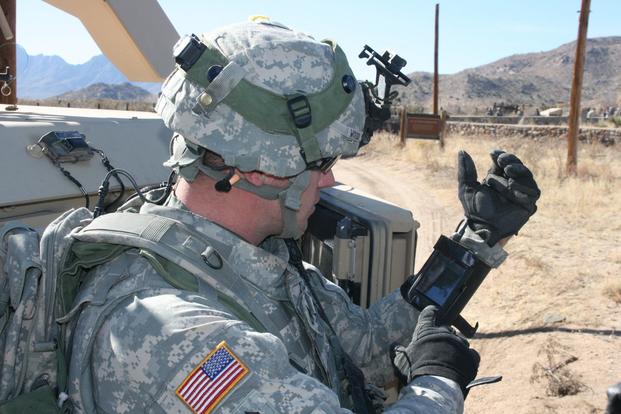
Staff Sgt. Reag Wood of 1st Combined Arms Battalion, 5th Brigade, 1st Armored Division, illustrates how he uses an iphone to obtain a visual image of a mock with insurgent activity during a field training exercise at White Sands Missile Range, N.M. (Photo: U.S. Army/Lt. Col. Deanna Bague)
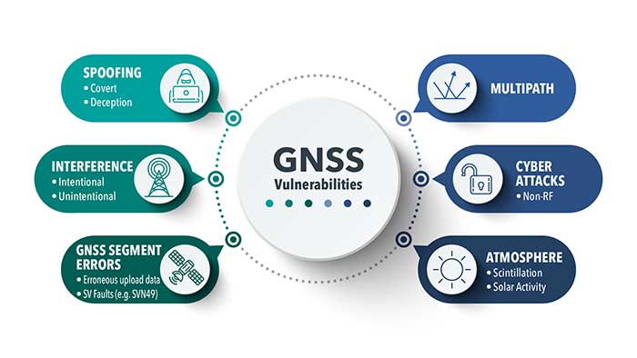
In 2019, military forces witnessed the global threat of GPS/GNSS interference grow, with more sophisticated threats and increasing military demand for assured operations in Navigation Warfare (NAVWAR) and GPS-denied environments.
Enemy forces are deploying more advanced jamming and spoofing technologies worldwide, jeopardizing the security and reliability of positioning, navigation and timing (PNT) data that feeds into GPS receivers, downstream networks and subsystems.
Military forces must vigilantly protect their information advantage from malicious attacks by delivering situational awareness, mission planning and warfighter solutions.
For these priorities, proven and efficient signal integrity solutions will be even more critical in 2020.
Requirements to Ensure Signal Integrity in 2020
Any critical system that relies on PNT data should go into the field with two known states:
First, it should withstand a GPS outage during testing and simulation — including rigorous jamming and spoofing simulation to predict how the system will react under various conditions. Simulation scenarios can vary in complexity, and newer software-defined simulators provide flexibility to meet current requirements while future-proofing investments in test equipment.
Second, the system should have a signal threat detection and alert mechanism. Critical systems also need backup layers such as anti-jam antennas, threat mitigation technology and alternative encrypted signals to ensure continuous operations, even in compromised environments.
Going into 2020, GNSS simulation and interference detection and mitigation (IDM) will continue to adapt to emerging threats and provide the essential foundation for Assured PNT.
For more about Resilient PNT and NAVWAR solutions, visit www.Orolia.com.
By Javier Benedicto
Head, Galileo Programme department,
European Space Agency
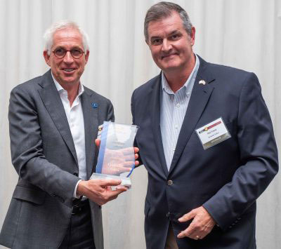
Javier Benedicto, left, accept the 2018 GPS World Satellites Leadership Award on behalf of Giuliano Gatti of the European Space Agency, from Phil Froom of Rockwell Collins. (Photo: Melanie Beus)
Since the Galileo initial services declaration in December 2016, the Galileo Program has been providing global PNT and search-and-rescue services for users worldwide. The European GNSS Agency (GSA) just issued its GNSS 2019 Market Report in October, providing a complete overview of the current status and trends of the GNSS worldwide market with focus on European GNSS (Galileo and EGNOS) applications and services.
In parallel with service provision, the Galileo Program is undertaking extensive infrastructure development and deployment activities to reach Full Operational Capability (FOC), incorporating new service capabilities, but above all aiming at increasing the robustness and resilience of the system infrastructure, operations and service provision.
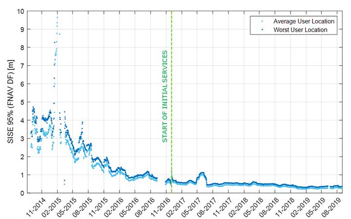
Galileo’s signal-in-space quality has steadily improved over the past few years, reaching in 2019 a best signal-in-space error (SISE) of about 0.25 meters (95%, global average; Figure 1). This has been achieved through a combination of several factors, including the increased number of operational satellites, enhanced versions of the Ground Mission Segment, and higher uplink rate of the navigation message (lower age of data). This performance is well within Galileo’s initial service accuracy commitments, as defined in the public Open Service – Service Definition Document (OS SDD).
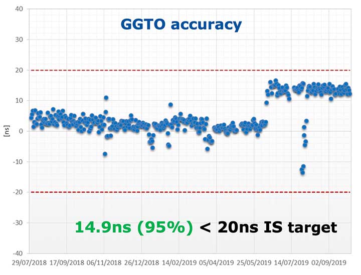
Figure 1. Long-term historical SISE plot over a 30-day sliding window, constellation averaged. (Image: ESA)
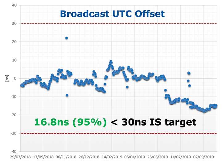
Figures 2 and 3 (see page 40) show Galileo’s timing performance as broadcast UTC offset and GGTO accuracy. The evaluation was performed with calibrated GPS/Galileo timing receivers operated in UTC(k) laboratory (PTB, INRIM). Again, the initial timing service commitments have been fully met.
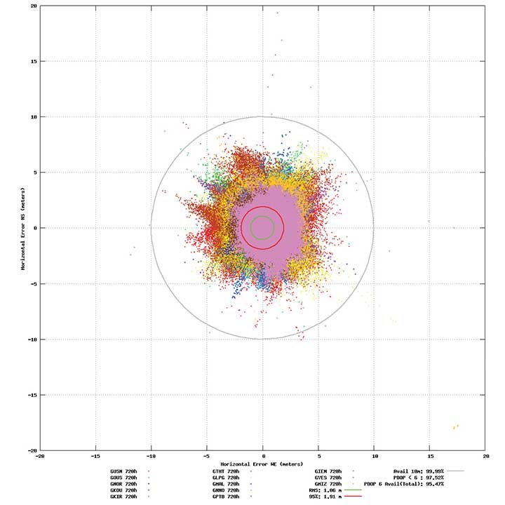
Probably the most significant discriminator of Galileo compared to other GNSS is its capability to broadcast multi-frequency (E1, E6, E5) signal components on all operational satellites. The position performance of a dual-frequency user receiver on-ground is shown in Figure 4. This measurement from June 2019 demonstrates a Galileo position accuracy well below 2 m (95%).
Figure 4. Galileo position accuracy performance, dual-frequency, June 2019. (Image: ESA)
With the aim of further improving the Open Service (OS) performance, three newly introduced I/NAV message improvements on Galileo E1-B are under implementation, namely FEC2 Reed-Solomon Clock and Ephemeris (CED), Reduced CED, and Secondary Synchronization Pattern (SSP). Galileo Open Service (OS) users will benefit from improved robustness in terms of navigation data retrieval in challenging environments, in addition to facilitating a reduced time to first fix. Those I/NAV improvements on Galileo E1-B are backwards compatible with previously released OS SIS ICDs.
In addition, Galileo infrastructure is currently being upgraded to provide means for OS authentication. The protocol proposed uses the E1B External Data Broadcast Service (EDBS) to provide authentication data to the user. The OS Navigation Message Authentication (NMA) is based on an adaptation of the Timed Efficient Stream Loss-tolerant Authentication (TESLA) protocol.
Beyond the OS, the Galileo system has been designed to allow for the dissemination of value-added data, such as high accuracy and authentication, in the E6B signal component. The component has been designed to broadcast the Galileo High Accuracy Service based on the provision of accurate satellite data (clocks, orbits and biases) and atmospheric data (mainly ionospheric corrections) to enable multi-frequency multi-constellation PPP with correction data transmitted through an open format in the Galileo E6B signal.
The introduction in early 2020 of the automatic acknowledgment of the SAR/Galileo Return Link Message (RLM) as part of the Cospas-Sarsat system will enable space assets to be used for search and rescue — persons in distress will get swift acknowledgement that their alert has been detected and located. The Return Link is the means to interact with a SAR beacon, improving the effectiveness of SAR operations. Extensive testing has demonstrated that the median latency for the reception of a return link message on the ground is 14.2 seconds, while 99% of messages are received within 57 seconds, after the request for the RLM transmission is delivered to Galileo (from Cospas-Sarsat to the RLSP). At the same time, the measured rate of reception was 100%, considering line-of-sight availability, thanks to the very robust Galileo navigation data link. This performance has been demonstrated to be uniform across the globe, as shown in Figure 5.
Figure 5. Beacon activation map and RLM delivery latency through the Galileo system. (Image: ESA)
Following the re-profiling of the Galileo Safety-of-Life (SoL) service, Galileo is meant to be exploited through dual-frequency multi-constellation (DFMC) SBAS and will support the provision of integrity through the concept of Horizontal Advanced Receiver Autonomous Integrity Monitoring (H-ARAIM). To allow the exploitation of Galileo for these SoL applications, a thorough analysis of the actual signal-in-space (SiS) performance and of potential feared events critical for SoL users is key. In this context, the Galileo Integrity Failure Mode and Effect Analysis (IFMEA) process is implemented through measurements and review of the system design, including feared-events characterization.
Ground Segment Brings Robustness
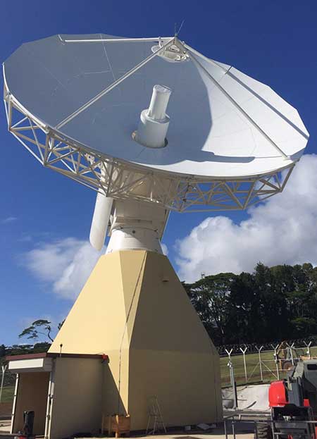
Galileo telemetry and telecommand ground station. (Photo: ESA)
Galileo’s Ground Segment is being upgraded to fully redundant control centers. These include processing and storage, monitoring and control facilities, and security monitoring centers. A worldwide network of Galileo Sensor Stations (GSS) allows monitoring and measuring of satellite signals; uplink stations allow dissemination of the navigation message to users through Galileo satellites; and telemetry, tracking and control (TTC) stations allow monitoring and control of the satellites.
Ground segment upgrades under production by Thales Alenia Space France (in charge of the ground mission segment and security monitoring) and GMV Spain (in charge of the ground control segment) are addressing increased service robustness, through the introduction of a more flexible infrastructure with a significant technology refresh, improved security, service continuity, enhanced service performances, and enhanced operability features.
One important objective of the ongoing upgrades is to implement a modern infrastructure, based on leading virtualization technologies. This modernized infrastructure will make it possible to easily accommodate hardware and software changes without requiring significant redesign or requalification, and will minimize the impact to Galileo service operations — under responsibility of Spaceopal GmbH — during future deployment activities.
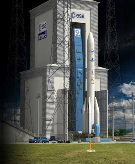
Batch 3, Ariane 6 Under Production
Ariane 6 on the launchpad. (Artist’s concept: ESA)
The production of Batch 3 of 12 additional Galileo FOC satellites is proceeding, aiming at readiness for launch by the end of 2020 onward. The satellite design includes a selected number of improvements compared to the 22 FOC satellites launched previously and built by the same satellite manufacturer OHB Systems.
The different stages of assembly, integration and initial test phase in the OHB production plant in Bremen have already started, before shipment to ESA-ESTEC in the Netherlands for the environmental test campaign consisting of thermal vacuum, mechanical tests, interface verification with the launcher and system end-to-end performance tests with the elements of the Galileo ground segment.
Following the phasing out of the Ariane 5 SE launcher, the third batch of Galileo satellites will be progressively launched with the new Ariane 62 launcher vehicle, the two solid-booster variant of Ariane 6 now in the final stages of development.
Evolution to Meet User Needs
The Galileo Second Generation roadmap has achieved maturity in 2019 and is now entering the preliminary design and implementation phase. Based on the EU’s H2020 Galileo Second Generation activities managed by ESA, and the GSA prospective market analysis, the European Commission, in close consultation with EU member states, has agreed on an ambitious set of long-term PNT goals for the future European GNSS infrastructures.
Technology pre-developments, critical engineering activities and synergic design activities between space and ground infrastructure are being conducted. This will translate into the progressive deployment of a complete set of space/ground infrastructure that is tailored to satisfy the diversified user needs in four main dimensions:
Satellite and ground segment infrastructure with capabilities that can dynamically adapt to current and future user needs. Key drivers are flexibility and robustness, ensuring fast time to market to meet user needs.
Full synergy between GNSS and SBAS systems infrastructure, to complement and enhance the service portfolio. This will allow segmentation and complementarity of safety-critical services and extension to all new PNT services available today, including high-accuracy positioning integrity.
Enhanced integration with terrestrial systems — 5G/6G, signals of opportunity (SOOP), terrestrial beacon systems (TBS). ESA and GSA have been actively leading the 5G positioning standardization worldwide in collaboration with public and private institutions inside 3GPP and will soon move toward the start of standardization of 6G terrestrial positioning and GNSS interconnection technologies.
Full complementarity with external sensors (such as INS, barometer and lidar) and application environments (low-power devices and internet of things) so that the Galileo Second Generation Infrastructure enhances and complements the capabilities provided by these external means.
A key pillar for this long-term strategy is the Galileo transition satellites. The competitive procurement procedure for the first batch of transition satellites is coming in 2020. The flexibility and robustness of these satellites will allow the European PNT infrastructure to satisfy all the different user needs in the next decade. This procurement — together with others at system, ground segment and technology level — will enable the start of the in-orbit validation of second-generation capabilities from 2025 onward.
Additional ground and test infrastructure are in early engineering analysis, design and technology development, in order to proceed with additional procurements for experimental and operational usage, starting early in the 2020s.
TDKC has proven capabilities in microelectronics trust and assurance, space domain awareness, and advanced visualization for enhanced situational awareness. PreTalen’s core competencies are the related practices of cyber warfare, navigational warfare, and positioning, navigation and timing (PNT) techniques and technologies in support of defense and offensive operations to counter adversaries.
Both companies are headquartered in Dayton, Ohio.
The acquisitions more than double the number of Centauri employees in the region to more than 300, supporting customers across the space, cyber and intelligence markets.
In addition, to bringing TDKC and PreTalen’s capabilities to bear for Centauri’s broader customer base, Centauri is building additional research and development labs, and secure facilities in the Dayton region to expand innovation and cutting-edge solutions for Centauri’s customers.
“Both TDKC and PreTalen have exceptional talent and share a common culture of innovation in pioneering new capabilities for the warfighter” said Dave Dzaran, CEO of Centauri. “With TDKC, we are building world-class capability to help ensure trusted microelectronics in the supply chains for the defense and intelligence communities. Their expertise in space domain awareness brings additional AI and machine learning technology to further strengthen Centauri’s existing space-related mission capabilities focused on the next generation of solutions that will serve this rapidly-evolving domain.”
“Similarly to TDKC, PreTalen’s unique skill sets relating to all aspects of the PNT architecture serve as a true differentiator on their programs,” said Dennis Kelly, president and COO of Centauri. “PreTalen has built a critical mass of the most innovative employees in both PNT and cyber, and we are excited to facilitate collaboration not only with our Dayton operations but also across the rest of our company.”
Greg Gerten, CEO of PreTalen, and Dan Schiavone and Eric Loomis, founders of TDKC, as well as both of their leadership teams, including Bruce Hart, will become a part of Centauri’s growing operations in the region.
This investment in the Dayton region comes on the heels of Centauri’s hiring of Col. Elena Oberg, former vice commander of the Air Force Research Laboratory, headquartered just outside Dayton at Wright-Patterson Air Force Base.
With the addition of TDKC and PreTalen, Centauri now has more than $475 million of annual revenues and 1,650 employees, approximately 20% of which support customers located in the Dayton market.
“I speak for all of PreTalen when I say that we are extremely excited to be joining forces with Centauri,” Gerten said. “Our team is eager to apply our core capabilities to the space and Intelligence communities, and we look forward to replicating our past success for an ever-increasing number of customers. Furthermore, Centauri’s focus on innovation meshes well with what we’ve spent 12 years building here at PreTalen, and I’m thrilled to continue our journey with their support.”
What is or would be the best policy response from Congress and/or executive branch agencies to the growing threats to GPS from jamming and interference?
Brad Parkinson
“Homeland Security has declared GPS to be an essential system to virtually all of our infrastructure. It is time to install a national system to identify and shut down interference. As part of that, all cell phones should periodically report interference to that national system and allow law enforcement to pinpoint and eliminate offenders.”
-Bradford W. Parkinson
Stanford Center for Position, Navigation and Time
Allison Brown
“On Dec. 5, 2018, the president signed into law the National GPS Timing Resilience and Security Act tasking the Secretary of Transportation with establishing a backup timing system for GPS within two years. To date, only limited technology demonstrations have been performed. Congress needs to fund the Department of Transportation to rapidly acquire and deploy a back-up timing capability, using available commercial solutions, to assure resilience within the Air Traffic Control system and other critical infrastructure to GPS jamming or spoofing.”
-Alison Brown
NAVSYS Corporation
Members of the EAB
Tony Agresta Nearmap
Miguel Amor Hexagon Positioning Intelligence
Thibault Bonnevie SBG Systems
Alison Brown NAVSYS Corporation
Ismael Colomina GeoNumerics
Clem Driscoll C.J. Driscoll & Associates
John Fischer Orolia
Ellen Hall Spirent Federal Systems
Jules McNeff Overlook Systems Technologies, Inc.
Terry Moore University of Nottingham
Bradford W. Parkinson Stanford Center for Position, Navigation and Time
The U.S. Department of Transportation “…is seeking the best solutions to ensure that America has a combination of PNT [positioning, navigation and timing] systems which, when used together, will be difficult to disrupt” according to remarks made at a recently concluded conference.
Diana Furchtgott-Roth
Diana Furchtgott-Roth is the department’s Deputy Assistant Secretary for Research and Technology. She made the comments during a keynote address at the Royal Institute of Navigation’s annual conference in Edinburgh mid-November.
Trained as an economist, Furchtgott-Roth noted that Edinburgh was the home of Adam Smith who in the 1700s referred to the efficiency of free markets as an “invisible hand” guiding economies. She regularly referred to GPS as “the invisible hand” guiding individuals, transportation, and technologies across the globe.
Citing GPS as a “one of the great and heroic systems of our times,” she also acknowledged wide and generally unconscious reliance on GPS signals, and its vulnerabilities. “A lot of the work in research and technology at the Transportation Department…assumes the existence of GPS. It assumes that GPS will continue to work, sight unseen, without interference.”
A dedicated GPS-only receiver “sounds as outdated as a pager.”
While PNT is essential now, she said, it will be even more important in the future as it becomes essential for even more safety applications.
“Public confidence in these will be critical. People will not be comfortable getting into an automated vehicle or with platooning driverless trucks heading down the highway if they think that their invisible hand is not reliable and that their GPS might be spoofed.”
As part of this, development and adoption of a wide variety of space-based, terrestrial, and self-contained navigation sensors must be deployed and widely adopted. A dedicated GPS-only receiver, she said, “sounds as outdated as a pager.”
She also echoed the theme of protecting frequencies, toughening receivers, and augmenting GPS signals as a way of achieving greater PNT resilience.
The department let a contract in November for demonstration of 11 technologies that could serve as a GPS augmentation/backup system. Furchtgott-Roth said, “This effort will inform implementation of a system that by law is required to be terrestrial, wireless, have wide area coverage, be difficult to disrupt, and be capable of expansion to provide positioning and navigation services.”
Departing from her prepared script, she added, “The Department of Transportation hopes to come to a decision by next May. Then we will get together with the Defense Department and the Department of Homeland Security and chose a technology or combination of technologies… And then we hope that our Congress will allocate funds to purchase this equipment. Our top priorities are national and economic security. We cannot have GPS be a single point of failure for transport and other critical infrastructure.”
The United States published its National PNT Architecture Study in 2008 citing the need for an integrated and resilient approach. Despite its call for use of multiple phenomenologies and an implementation plan signed several years later little has been done as of yet now.
Furchtgott-Roth’s comments came roughly a month after a Chinese representative to a Stanford symposium that here nation was developing a national “comprehensive PNT” after the fashion of what was called for in the U.S.’s 2008 study.