SOAR Oregon, a non-profit organization focused on the development of the unmanned aircraft systems (UAS) industry in Oregon, has given the city of Pendleton a grant for the establishment of a FutureFarm project at the Pendleton UAS Test Range.
The Oregon UAS FutureFarm is a real-world proving ground designed to help digital agriculture pioneers accelerate product development, reduce cycles and expand market growth.
SOAR Oregon is exhibiting at AUVSI Xponential 2016, being held in New Orleans this week.
Pendleton Mayor Phil Houk (right) signs the FutureFarm grant agreement with SOAR Oregon. SOAR Oregon’s John Stevens (front left), Roundup City Development Corporation’s Mike Short (back left), and Pendleton UAS Range’s Steve Chrisman (back right) were on hand to witness the signing.
Once established in June, it will be the only digital agriculture proving ground of its caliber in the United States, SOAR Oregon said. Developers of agriculture-focused unmanned robotics and data systems will find the Oregon UAS FutureFarm has a broad spectrum of high value and commodity crops, multiple layers of remote sensing for benchmarking, and access to the agricultural knowledge base they need to test, validate and innovate the next generation of interconnected unmanned and automated agricultural systems.
The Oregon UAS FutureFarm features a network of research-friendly farmers growing a large variety of irrigated and dry-land crops in both traditional and modern farming infrastructures. Strategic partners include the City of Pendleton, Digital Harvest, SOAR Oregon, Blue Mountain Community College, Oregon State University and USDA Columbia Basin Agricultural Research Center.
“We believe that the Oregon UAS FutureFarm fills a clearly defined market niche for UAS platform and payload developers who are working on the next generation of technologies for precision agriculture,” said SOAR Oregon Executive Director Chuck Allen. “We are especially pleased that this project is taking place at one of Oregon’s FAA-designated UAS test ranges.”
“We are pleased to be supporting the Oregon UAS FutureFarm as both a partner and user,” said Young Kim, CEO of Digital Harvest. “The fact that the test range includes high-value tree fruit orchards, premium wine grape vineyards, hundreds of automated irrigated plots, and hundreds of thousands of acres of dry land farms makes it a unique and special zone.”
“The Oregon UAS FutureFarm is open to UAS developers, sensor makers, robotics companies, universities and any others who are looking for a real-world digital agriculture proving ground that is supported by a collaborative innovation focused community,” said Jeff Lorton, Oregon UAS FutureFarm project manager.
Pendleton Mayor Phil Houk signed the agreement with John Stevens and Mike Short from SOAR in attendance. “The FutureFarm represents what we’d hoped the Pendleton UAS Range could become — not just an environment for the development of technology, but the place where real-world questions could be solved with unmanned aircraft,” said Steve Chrisman, Pendleton director of Economic Development. “We are excited about the potential of this project to develop solutions which benefit growers across the Northwest.”
Numerous factors will impact the economics and logistics of how farmers and growers will use drones in 2016 and beyond, according to a new report offered by the Commercial UAV Expo.
In “Above the Field with UAVs in Precision Agriculture,” author Jeremiah Karpowicz examines factors such as:
Potential impact of new FAA regulations
Capabilities created or augmented with new sensor technology
The best approach to get in the air.
Download this free report, UAVs in Precision Agriculture and discover how UAVs are set to revolutionize this multi-billion market.
Farmers and growers are starting to use UAVs to increase both productivity and profitability with real-time data, to improve decision making in areas such as for crop scouting, nutrient management, field mapping and water drainage.
By Yacine Bouroubi Effigis Chief Scientist, Earth Observation Division
Canadian agriculture has an international reputation for being highly productive and modern. It plays a major role in the country’s economy, and contributes to 8 percent of GDP and 12 percent of jobs.
Everyone involved in Canada’s agricultural sector is aware of the environmental issues associated with farming. To optimize performance and revenue while respecting the environment, for the past few years producers have been counting on a new ally: precision agriculture.
Using technologies such as GPS, auto-guidance, variable rate technology, yield sensors, satellite images and drones, precision agriculture is now part of the day-to-day life of farmers. The application of agricultural inputs based on the four Rs (the right source at the right rate, in the right place at the right time) must be based on scientific knowledge and technical know-how. Such knowledge and know-how are based on reliable, accurate and complete information, which is often necessary on a global scale, but with a rather fine spatial resolution. Satellite images are the ideal tool to provide much of the information required.
The SCAN program extracts agronomic knowledge related to nitrogen fertilization to make more accurate models. (Image: Effigis)
Using Satellite Images. For about 15 years now, sensors on very high spatial resolution (VHR) Earth observation (EO) satellites have been offering a source of data that can provide information on soils and crops at adequate spatial scales (around 2 meters using multispectral imagery) with an unbeatable price/quality ratio. Products derived from satellite images for estimating the quantity of nitrogen fertilization to meet plants’ nutritional requirements are a concrete example of an operational use of this data.
Determining the optimal dose of nitrogen is not easy, since it depends on complex interactions between plants, the soil, weather conditions and management practices. By wanting to avoid performance loss due to nitrogen deficiencies, current practices favor overfertilization, which leads to unnecessary costs as well as serious environmental problems.
Agriculture and Agri-Food Canada developed a model based on statistical analyses for understanding the direct relationship between the properties that influence nitrogen requirements (soil, growth, weather and management) and the response to nitrogen fertilization, based on a large number of fertilization trials. These relationships were implemented in a system called SCAN (Soil, Crops and Atmosphere for Nitrogen). Satellite imagery acquired at a specific growth stage provides information required for the operation of SCAN.
SCAN includes two major innovations: extracting agronomic knowledge related to nitrogen fertilization and modeling this knowledge in the form of inference rules in a fuzzy logic system. Work is ongoing to advance these two aspects of SCAN and validate it for various agricultural regions, as well as adapt it to various types of crops.
A SCAN web platform will be tested by 100 users starting in the summer of 2016, in anticipation of its commercial use in 2017.
Topcon Positioning Group has released a new 3D dozer machine control system — 3D-MCMAX. The system is driven by dual IMUs (inertial measurement unit) designed to increase on-grade performance where speed and blade response is maximized, while eliminating the need for a mast on the blade.
The system uses Topcon 3D-MC2 technology with the dual IMU sensors and new, unique algorithms to deliver an integrated solution that locates the sensitive GNSS technology safely inside the cab instead of out on the harsh environment of the blade.
“The 3D-MCMAX is the next generation of dozer grading solutions that redefines the concept of machine control,” said Jamie Williamson, executive vice president and general manager of the Topcon Precision Automation Group. “It provides high-accuracy elevation, slope, and blade rotation sensing in an integrated configuration resulting in maximum speed, maximum control and maximum grading performance.”
The system is designed to let operators work confidently in rough or fine grade applications, slope conditions, and in restricted sight environments without the visual obstruction of masts or risks to hanging cables.
“This advanced system is a result of our clear understanding of how technology is driving the evolution of the construction world, and focusing our improvements on smart algorithms in our firmware and software to increase the productivity of the hardware — a full systems approach,” said Williamson. “The added bonus is a clean integration onto the equipment. Gone is the need for daily installation and removal of antenna, cables, and mast. With 3D-MCMAX, the operator just climbs on and gets to work — downtime is minimized.”
AgStudio can now read as-applied maps and production data from Connected Farm. Previously, AgStudio software users could only read harvest data from Connected Farm.
Users with current subscriptions to AgStudio software are able to communicate seamlessly with Trimble field devices and wirelessly transfer field data, as-applied maps and production data from planters, spreaders and sprayers as well as combines for harvest data.
The recent integration taps into the new Trimble Connected Farm file transfer API, which provides data sharing access with the Connected Farm solution, and offers AgStudio software users more flexibility in importing data from an even wider variety of company systems.
“This integration with Trimble’s Connected Farm solution allows our customers greater access to information that streamlines production management,” said Ted Macy, vice president of operations at MapShots. “Whether it’s variable rate seeding, variable rate fertility, or managing harvest data, AgStudio software users now can import even more valuable information and make decisions based on activities carried out by Trimble guidance and steering systems.”
Trimble’s Connected Farm solution combines industry-leading hardware and software to increase efficiency and enable better decision making. Together, the two companies allow agricultural providers to better manage production data.
“The integration with MapShots AgStudio software fits into Trimble’s Connected Farm strategy to provide growers a more complete picture of their field activities while allowing them a choice of software tools to analyze data and make production decisions,” said Pierre-Andre Rebeyrat, strategic marketing director of Trimble’s Agriculture Division. “We are excited to welcome MapShots to the growing list of companies that have taken advantage of the Connected Farm file transfer API.”
For further information, users can contact their regional MapShots sales representative at 678-513-6093 or e-mail MapShots at [email protected].
Reynolds is director of Inta Communication Ltd. and a long-term Brussels observer writing on many aspects of European government policy and implementation for a range of clients and publications. He is the contributing editor for GPS World’s new quarterly e-newsletter, EAGER: the European GNSS and Earth Observation Report.
The annual summit, held in the historic Munich Residenz, is an conference with global impact dealing with satellite navigation. The one-of-a-kind convention of high-ranking worldwide speakers from industry, science and governments provides the participants with a broad overview and different perspectives on the latest developments in the field of GNSS.
Reynold’s session, GNSS and Sciences for Life, will cover maritime search and rescue (SAR), precision agriculture and livestock management, personal fitness and emergency medical attention.
Other sessions include:
GNSS Program Updates — Global systems, chaired by Hank Skalski, Department of Transportation, DOT Liasion to Air Force Space Command, Peterson Air Force Base, USA
GNSS Program Updates — Regional and augmentation Systems, chaired by Dr. Todd Walter, Stanford University, CA, USA
GNSS in the Southern Hemisphere and Equatorial Regions, chaired by Prof. Vidal Ashkenazi, Chief Executive of U.K.-based Nottingham Scientific Ltd, Nottingham, UK
Precise Positioning Technology in Agriculture and Forestry, chaired by Dr. Herbert Landau, Managing Director, Trimble Terrasat GmbH, Hoehenkirchen, Germany
Legal Issues of GNSS Timing, chaired by Dr. Ingo Baumann and Dr. Oliver Heinrich, Partner, BHO Legal, Cologne, Germany
Plus, expect a brand-new conference format for this session:
The GNSS Knowledge Triangle: Tying the Knot Between Education, Research and Industry, chaired by Dr. Fabio Dovis, Associate Professor, Politecnico di Torino, Turin, Italy
The summit is part of the efforts of the Bavarian government and the cluster on aerospace and satellite navigation to stimulate applications and services in this high-tech field.
HarvestMaster, provider of agricultural data collection solutions, has introduced a new field applicator that applies various treatments to specific field plots. The field applicator is easily controlled from within HarvestMaster’s Mirus field data-collection software using a software plugin.
Using the Mirus field applicator plugin, users can select which treatments to apply to individual plots from within the Mirus dashboard, and can choose to control the field applicator either manually or automatically, based on GPS location. The system significantly reduces error in treatment applications and improves productivity by streamlining the application process in the field, according to Juniper Systems, parent company of HarvestMaster.
Compatible with a wide range of research spray systems, the Mirus field applicator plugin eliminates the usual bulky and often confusing toggle switch boxes that are typically used to control field applicators. The user imports a file that specifies which formulation is to be applied to each plot, then selects whether to control the applicator either manually or through GPS positioning data, and the system is ready to go.
As technology continues to march forward, and storage and data evaluation use grows, the surveyor and the farmer will begin to use each other’s skillsets to increase their own productivity. So how do we get there? First, we must establish how each side uses their prospective GPS tools.
As a child, I spent several summer vacations at my relatives’ farms in central Illinois. My early impression of working on a farm was one of long hours and hard work. Work and chores completed by my family members was very physical with no set hours to look forward to. My uncles didn’t get to set the schedules for rain and sun and had no say in whether or not a piece of equipment would break down.
What I encountered as a child taught me that there was no technology in farming; it was nothing but hard work. The thought of using something as high-tech as GPS would have made most old-time farmers laugh you right out of the coffee shop.
My career as a land surveyor has had its share of hard work at times, but it has been the technology that has always fascinated me. When I began as a rodman, the electronic distance meter allowed surveyors to measure distances more than a mile instead of hand taping the entire way, and with much more accuracy. Along the way, I’ve watched computer technology grow, with total stations that incorporate cameras and video and GPS receivers that provide accurate locations instantaneously.
That brings us to our modern-day crossroads. As surveyors, we are constantly trying to find ways to incorporate our skills into other occupations to increase productivity. We also see the modern farmer moving away from small family operations with only several hundred acres, morphing into farm management corporations with tens of thousands of acres as well as millions of dollars of equipment.
Efficiency is what they are after, and they are spending significant amounts of money on technology to make it happen. My own curiosity and research has opened my eyes to how far the farming profession has grown, and in many ways surpassed the land surveyor with technology. But I think there is still common ground that needs to be explored, so let’s start at the root of each profession.
The Farmer and the Surveyor
As different as the two professions may seem, farming and surveying have one large common link: data. More specifically, the tools, methods and procedures they operate to acquire the data used in their everyday jobs and projects.
The implementation of GPS equipment and the ability to collect location data has greatly improved the productivity of both professions, but for drastically different reasons. However, as technology continues to march forward, and storage and data evaluation use grows, the surveyor and the farmer will begin to use each other’s skillsets to increase their own usefulness.
So, how do we get there? First, we must establish how each side uses their respective GPS tools.
The Land Surveyor
The land surveyor and his or her staff use GPS daily, with varying degrees of accuracy. Here are a few examples:
Mapping-Grade GPS Device (>= 3 meters)
This handheld unit is primarily used for mapping utilities and improvements that don’t require high accuracy. The data and attributes acquired by this unit will be inserted into geographic information system (GIS) databases for inventory, and maintenance logs for future review and upgrade needs. Surveyors use these units for mapping items that require additional attributes and information necessary to improve the overall usefulness of a GIS database.
Differential GPS (<= 1 meter)
Differential GPS provides live positional solutions for applications that require more accuracy than mapping-grade GPS, at a reasonable equipment and operational price. These systems are used by aeronautical companies for mapping assistance, logistics companies for asset tracking, and emergency operations for 911 systems. These systems are also used by hydrographic surveyors for use in mapping lake and river bottoms as well as surveyors working in open pit mines, producing existing condition maps and volumetric surveys.
Survey-Grade GPS
Surveyors began implementing GPS equipment into their measuring repertoire in the mid 1980s with the introduction of data collection by static methods. This technique allowed for long-distance measurements with good accuracy and precision, but it came at an incredibly expensive cost.
By the mid 1990s, real-time kinematic (RTK) equipment was introduced, and gave the land surveyor a new gateway into long-distance measurement with shorter occupation time and less cost. Additional enhancements to RTK systems included on-the-fly initialization, increased data-collector capability, and cellular/long-distance radio networks.
These improvements allowed increased data-collection productivity, including mobile collection on all-terrain and survey vehicles. A topographic survey of a 40-acre parcel that would take several days of walking now is completed in less than 6 hours on an ATV. Boundary retracements of large parcels that used to take weeks of traversing the perimeter can now be done in a few days.
Many credit GPS technology and functionality for greatly improving land surveying production as well as increasing accuracy and precision of the work.
Farming has been passed down from generation to generation for hundreds of years. History tells us this has been a hard life for many of these families as manual labor was at the root of the occupation. Livestock and family members were used to pull the necessary implements for planting each year’s crop, with most harvesting being done by hand.
The Industrial Revolution brought the tractor and planting and harvesting equipment. After World War II, equipment manufacturers retooled their factories to increase the size and capacity of tractors. Even with the reduced manual labor that a farm tractor allowed, it was still a physical burden on the farmer planting crops and driving the miles of rows necessary to plant fields.
Also, many agricultural areas became more organized, with local farm bureaus and associations being formed to help the farmer. These organizations provided information on how to increase yields in their crops; this data became the basic form of a GIS database for soils and drainage mapping well before digital mapping. These databases provided the initiative for the farmer to analyze planting methods and rates; herbicide, pesticide and fertilizer applications; and to review crop yields for notable increases and deficiencies.
In the 1980s, yield monitoring equipment became a new tool for the forward-thinking farmer to invest in, analyzing how well his crops were producing. The only negative was the inability to accurately map the location of the various yield rates that would occur in the harvest. The farmer was forced to spend more time reading the yield analyzations in smaller parts of his fields in order to identify where adjustments were needed for increasing the output. Many farmers didn’t see the return on investment for this system, and those who did purchase such a system soon gave up.
In the early 1990s, Rockwell International debuted the Vision System, a GPS unit using a U.S. Coast Guard correction system paired with a yield monitoring unit to map the location of yield rates during field operations. Trimble, John Deere and others were soon developing their own systems. All of these systems were expensive, delicate and too complex for most farmers to justify installing in their tractors.
However, new discoveries in GPS technology during the late 1990s brought sweeping changes to this new tool for the farmer. While the term “precision agriculture” had floated around for a while, it wasn’t until the introduction of high-accuracy GPS that the statement reflected correctly on the industry.
Differential GPS (<= 1 meter)
John Deere began its pursuit of GPS technology in the early 1990s along with many others, but the company’s decision to continue pursuing this competitive edge is what led to several advancements for the farming industry. Deere’s work with Stanford University and NASA led to the revision of differential corrections for GPS locations to gain additional accuracy for a guidance system for Deere equipment.
By 1998, John Deere presented a differential GPS system that provided 1-2 meter accuracy to assist farmers with smaller tolerances of precision field planting and harvesting. Innovations such as this led to many more advancements in the farming industry.
Real-Time Kinematic (<= 2.5 centimeters)
Today’s precision farming is more accurate than ever, with RTK networks providing a bulk of the coverage necessary to supply the farmer with corrections. In places where a local correction provider is not available, the farmer has choices of setting up his own base for correction or subscribing to other real-time networks via cellphone coverage. These systems allow for highly accurate mapping and guidance systems so the farmer has more control and information on his field and crops than ever before. Farmers now using GPS control in precise methods have more tools for increasing yields and production, including crop planning, soil sampling, pesticide/herbicide/fertilizer application and harvest analyzation.
Crop planning used to be strictly in the hands of the farmer who drove his tractor in his field in an effort to follow the lay of the land. Today’s farmer uses topographic maps, aerial photography and mapping software to create planting patterns that make farming more efficient. By maximizing the planting configuration, this is also an opportunity to minimize fuel consumption. Soil sampling and weed mapping are now staples of many farmers’ activities.
The farmer uses these methods to reduce the number of contaminants within the crop. He can also analyze the field’s health in order to apply the appropriate amount of necessary chemicals. These procedures are now computer controlled to vary the rate of application depending on the location within the field.
Harvest analyzation has become the biggest source of data collected. Yield monitoring equipment was the first tool introduced into the electronic farming age. Now, coupled with GPS mapping of yield rates and volumes, farmers can accurately predict spot, regional and overall crop production from their fields. This data, along with soil mapping, is reviewed after the harvest and is used to determine a strategic plan for the next year’s planting.
The biggest improvement, in most farmers’ opinions, is the implementation of steering-guidance systems. Initially produced to be strictly a guide to the driver, systems are now automated into the steering system to follow a predetermined path within a 1-inch tolerance. This frees the driver to monitor planting, spray application and harvesting operations.
By turning the driving over to an automated system, field row overlap is reduced by up to 30 percent. This decreases double coverage of seed and spray application and it minimizes fuel consumption. This system also allows for less driver fatigue with the ability to work around the clock as needed or conditions dictate. Coupling this steering system with variable rate planters and sprayers, the farmer has a system that allows him to be more effective in managing and monitoring operations.
Bringing the Two Occupations Together
Both of these noble professions are using a highly accurate form of measurement and data recording, but we must review further how they can help each other. To do that, we must analyze what each is doing with the technology.
Surveyors and GPS Use
Roles of the surveyor are to measure land, provide his professional knowledge regarding parcel boundaries, and collect data for engineering and drainage purposes. A majority of this data is now collected by GPS methods and is in NAD83 state plane coordinates with NAVD88 elevations. This information can be supplemented by county and state GIS data as well. Surveyors also have knowledge of existing monuments by local, state and federal authorities tied to these coordinate systems/datums so all future surveys can be related to each other geographically.
Farmers and GPS Use
Farmers who have embraced GPS technology now have the power not only to map and collect data, but to also utilize previous data for crop efficiency. This ability to run a more efficient farming system is happening now for many farmers. The farmer is educated in regard to seed germination, weed and bug prevention, and maximizing crop yields so collecting this data has become a necessary task.
The Farmer and the Surveyor — Harvesting Data
The farmer and the surveyor can use their knowledge in many ways for the mutual benefit of increasing crop yields, efficiently working the land, and maximizing production.
The surveyor’s knowledge of topography and drainage can assist the farmer with shaping of land to minimize water runoff and loss of key nutrients in the soil. This loss is estimated to be an average of two to three tons of soil per acre per year. Installation of drainage tile in addition to grading can be a critical part of minimizing soil loss, and the surveyor can help with this analysis.
Accurate boundaries allow the farmer to know the limits of his property. The surveyor can provide this information so the farmer can maximize his planting configuration, yet not encroach on the adjacent property. The surveyor can also help with the creation of land-management systems to help farmland owners plan for financial decisions and tax strategies.
The biggest opportunity for the surveyor is to offer assistance to the farmer who has little or no knowledge of data collection. This geospatial data can be confusing to those not familiar with this information. Farmers who become educated in analyzing and reading crop data can increase production and yields.
Surveyors have the math skills and background to assist with the management of the data from a location standpoint. This effort will help the farmer know soil conditions, germination, spray application and harvesting to maximize the cost effectiveness of his investment in the land.
Together, the farmer and the surveyor can create a successful partnership that can increase crop production worldwide. Data is the crop that brings them together, and planted with the right amount of care and nurturing, this data can become more valuable than ever.
Google and the big automakers might get the lion’s share of attention when it comes to autonomous road vehicles, but John Deere has been making self-driving tractors for more than 15 years.
Among them is the 9RX tractor, which can steer itself, freeing the farmer to focus on business. The 9RX, introduced in August, features an articulated steering system and an optional Active Command Steering (ACS), which improves maneuverability in the field and line-holding ability at transport speeds.
Hands-free driving: Ag companies take the wheel. (Photo: John Deere).
Farmers don’t need to navigate other traffic, just make optimal use of fields. Before farmers began using GPS to plan routes, a few feet would get reworked in every row. With GPS-based auto-driving accurate down to the inch, missed spots and repetition are avoided, saving farmers time, fuel and money.
With a tractor the only moving object in a vast acreage, collisions are highly unlikely. Still, a driver still needs to be at the tractor’s wheel. Unlike consumer vehicles being developed for autonomous operation on public roads, the tractors don’t have external sensors on all sides to prevent collisions. A fully autonomous tractor, which doesn’t require a driver, probably won’t hit the market before 2025, according to John Deere.
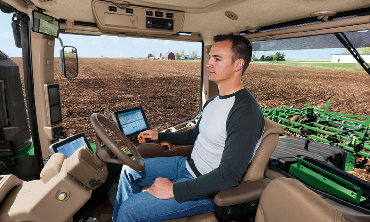
Inside the cab, farmers can equip their tractors with a variety of modular systems that allow computers control over operations, starting with a basic satellite guidance system and a touchscreen interface. From there, an add-on lets the tractor make precise turns autonomously, and another uses radio base stations set up around fields to supplement navigational accuracy. Besides the high-tech features, cabs of the 9RX have luxury touches such as an integrated refrigerator and high-quality sound.
Laser Navigation
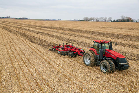
Other companies that offer auto-steering include Case IH and Autonomous Tractor Corporation.
Case IH offers guidance and steering for use on tractors, such as its Magnum 340 Tractor. (Photo: Case IH)
Case IH provides steering and guidance tools for tractors, combines and sprayers. Its AFS AccuGuide auto guidance enables repeatable accuracy down to sub-inch levels. AFS RowGuide works with AFS AccuGuide to provide accurate, hands-off steering for corn harvests. Two mechanical touch sensors mounted on the corn-head dividers sense row position and provide guidance input in concert with GPS.
Autonomous Tractor bills itself as a non-GPS system without dead spots or signal interference. Instead, it uses a proprietary laser-radio navigation system (LRNS) for sub-inch positioning data, along with its own FieldSmart software that allows farmers to “train” the tractor without programming.
Sonar systems provide full perimeter safety, and pan-tilt cameras communicate via cellular to allow the farmer to monitor progress and remotely resolve issues.
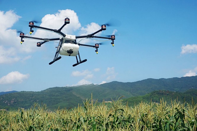
Unmanned aerial vehicle maker DJI has launched of a smart, crop-spraying agricultural drone. The DJI Agras MG-1 is dustproof, water-resistant and made of anti-corrosive materials. It can be rinsed clean and folded up for easy transport and storage after use.
The eight-rotor Agras can load more than 10 kilograms of liquid for crop-spraying and can cover between seven and 10 acres per hour. It is more than 40 times more-efficient than manual spraying, according to DJI. The drone can fly up to eight meters per second and adjusts spraying intensity to flying speed to ensure even coverage.
The Agras features DJI’s flight-control system and microwave radar to ensure centimeter-level accuracy. During flight, the drone scans the terrain below in real time, automatically maintaining its height and distance from plants to ensure application of an optimal amount of liquid. DJI’s real-time Lightbridge 2 transmission system is also onboard.
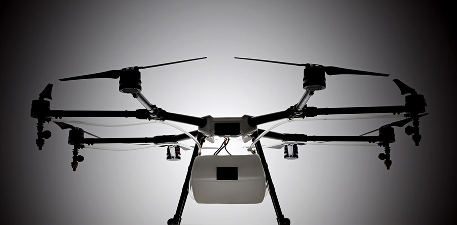
The DJI Agras MG-1.
Users can select automatic, semi-automatic or manual operation modes, depending on terrain, with uniform spraying carried out via the drone’s nozzles. The drone has four replaceable, ceramic nozzles, each powered by a motor. The included nozzles can be used for thousands of hours of spraying. Downward airflow generated by the rotors increases spraying velocity and ensures the agent will reach plant stems and leaves near the soil.
The Agras MG-1’s body is sealed, and features an integrated centrifugal cooling system designed to extend motor life by up to three times. Triple-filtration cuts off intake of mist, dust and large particulates to reduce wear from impurities. As the drone flies, air enters the aircraft body via the front inlet. It is then filtered and passes through each of the aircraft’s arms to the motors, capturing heat from all components and the entire structure. Heat is then dissipated by venting into the surrounding air.
The DJI Agras MG-1 is designed for crop spraying.
The drone’s intelligent memory function means after the Agras MG-1 is brought back to base for refill or recharge, it will return to its last memory point to pick up spraying where it left off.
Users control the Agras with a custom DJI remote. Its low-energy display panel gives real-time flight information and lasts for extended periods on a single charge.
The Agras MG-1 will initially be available in China and Korea and later in other markets.
Deere & Company and The Climate Corporation, a subsidiary of Monsanto, have signed definitive agreements for Deere to acquire Monsanto’s Precision Planting LLC equipment business and to enable near real-time data connectivity between John Deere farm equipment and the Climate FieldView platform.
This news comes after a Nov. 2 announcement that the company had acquired Monosem, a European precision planting company. John Deere said it will work with Monosem’s existing engineers to further develop its precision planting technology.
The agreements represent the industry’s first and only near real-time in-cab wireless connection to John Deere equipment by a third party.
“To maximize the value of digital agriculture, farmers need solutions for simple and seamless collection of in-field agronomic data,” said Mike Stern, president and chief operating officer for The Climate Corporation. “As a result of these milestone agreements, farmers will experience the fastest, most frequent and highest resolution third-party connectivity between John Deere’s equipment and the Climate FieldView platform.”
“The agreements we are announcing allow John Deere to extend the range of retrofit options available from Precision Planting to many more products and into new geographies,” said John May, president, agricultural solutions and chief information officer at Deere. John Deere strengthens its position as the most open platform in the industry both in our equipment and the cloud-based data management solution known as the John Deere Operations Center.”
Under the terms of the agreements, Deere will purchase Precision Planting while Climate will retain the digital agriculture portfolio that has been integrated into the Climate FieldView platform. The acquisition is subject to customary closing conditions, including the approval of the relevant antitrust authorities to the extent required.
Stern said, “Our agreements enable farmers to combine the industry-leading technology of John Deere equipment with Climate FieldView, the platform that offers farmers the broadest equipment connectivity in the industry backed by data science. This connectivity allows farmers to collect and directly share data to the Climate cloud, enables data visualization in the cab and supports the development of customized data science-driven insights.”
“This strategic acquisition expands the John Deere precision agriculture business and accelerates our momentum as a market leader,” May said. “Strategic use of information is an important factor in successful agriculture. Today’s actions demonstrate John Deere’s ongoing investments to enhance the product and service solutions we offer our customers.”
The companies said customers will have the option to share their current and historical agronomic data between the John Deere Operations Center and the Climate FieldView platform and seamlessly execute agronomic prescriptions with John Deere equipment.
Trimble will acquire the assets of privately held AGRI-TREND of Red Deer, Alberta, Canada, which operates the largest network of independent agricultural consultants in North America. The acquisition will enable Trimble to provide agronomists and other crop advisors with a stronger set of brand-agnostic tools they can use to advise growers on how to better manage their operations, Trimble said in a news release.
The acquisition is expected to close in November 2015. Financial terms were not disclosed.
AGRI-TREND’s network of more than 200 specialists spread throughout the U.S. and Canada includes 110 independent “coaches” specializing in agronomy, precision farming, crop marketing and farm business management. Coaches are supported by a team of science specialists comprised of 30 Ph.D.s and M.Sc.s providing in-house research, training and insight support for both the coaching network and the AGRI-DATA Solution platform — a proprietary farm data-management solution. As a result, AGRI-TREND’s solutions enable growers to make informed business decisions that better allocate scarce resources to produce safe and environmentally sustainable food.
“Trimble’s acquisition of AGRI-TREND is another step towards total farm management for the grower. Together with Connected Farm, we will provide growers and their trusted advisors with a combined offering that is unique in the marketplace today,” said Joe Denniston, vice president for Trimble’s Agriculture Division. “AGRI-TREND is a leader in providing expert advice and decision support for growing crops, marketing commodities and managing a farm’s finances. Trimble is a leader in precision agriculture technology that precisely applies those decisions whether it is seed, nutrients or water. Together, Trimble and AGRI-TREND will enable the integration of decisions and execution to give greater control over the outcome, resulting in maximized productivity for the grower.”
“AGRI-TREND has been working side by side with farmers for over 17 years. With the strength that Trimble provides, we aim to help even more farmers as the move to precision agriculture continues to gain momentum globally,” said Rob Saik, founder of AGRI-TREND. “The combination of our advanced agricultural technical expertise and Trimble’s exceptional precision agriculture tools provides us with a platform that will support production practices that are sustainable both from an environmental and financial perspective for today’s farmers. We’re excited to be a part of the future of agriculture, and we’re pleased to work with the great people at Trimble.”
Full Farm Support
Grow the Crop: To assist in optimizing crop growth, AGRI-TREND has a network of experienced agronomists who serve as a personal Agri-Coach to help farm customers assess the performance of every acre on a yearly basis. Agri-Coaches work on the analytics, looking at the cost of production as well as nitrogen and water use efficiency, interpreting the data and making customized recommendations for each field. Recommendations are then followed up with field scouting and performance tracking to ensure farm goals are met.
Sell the Crop: To maximize crop sales, AGRI-TREND creates a Strategic Marketing Plan that includes business analysis, operational strategy, risk management and a harvest review. This customized plan is developed by an AGRI-TREND Market-Coach who works closely with each farm client to understand the unique situation of their farm and the cost of production for each field. The AGRI-TREND Market-Coach then provides advice on how to best achieve better selling prices, risk mitigation and optimal cash flow for their farm customers.
Manage the Money: In order to enable farmers to better manage their money, AGRI-TREND provides a network of business-coach professionals, which consists of experts in specialized areas such as accounting, banking, corporate finance and insurance. The business-coach starts by gaining an understanding of the farm business including strengths and weaknesses, measuring the farm’s performance against benchmarks, creating the Strategic Farm Business Plan and then implementing the farmer’s long-term growth plan.
The AGRI-DATA Solution
The AGRI-DATA Solution is a complete farm management platform that focuses on the unique agronomic challenges that farmers face every year as they work to maximize yields and profits. This platform is the foundation for AGRI-TREND advisors as they work on crop planning, crop input tracking, soil sampling, tissue testing, manure analysis, fertilizer blending, field scouting, harvest data tracking and more. The platform supports over 75,000,000 legacy acres with over eight million acres added in 2015. Farmers have also adopted the AGRI-DATA mobile applications for both Android™ and iOS devices, preferring to work with their information on the go.
Trimble Connected Farm Advisor
Trimble Connected Farm Advisor — a field data management tool for the farmer’s trusted advisor — will be integrated with the AGRI-DATA platform to empower AGRI-TREND coaches with a greater toolset to deliver more services to their growers.