Tag: precision agriculture

  • ‘Advancements’ with Ted Danson explores autonomous tech with Septentrio

    An upcoming episode of “Advancements” with Ted Danson will explore recent developments in autonomous vehicles such as drones, cars, trucks, excavators and other heavy machinery.

    The episode is scheduled to broadcast in the fourth quarter of this year.

    Image: Advancements
    Image: Advancements

    The segment will focus on Septentrio’s secure GNSS technology for unmanned systems. Septentrio is a designer and manufacturer of GNSS receivers and surveying equipment, delivering accurate and precise GNSS positioning scalable to centimeter-level even in challenging environments.

    Advancements will educate viewers about Septentrio’s GNSS technology, which provides both the accuracy and robustness required, while integrating and synchronizing seamlessly with navigation systems and payloads.

    “In a few years, autonomous cars will be driving us around, with greater safety, efficiency and comfort than ever before,” said Jan Van Hees, director of marketing and business development, Septentrio. “All of these vehicles depend critically on a multitude of sensors to determine where they are, with robust GNSS sensors at the heart of the system. It is critically important that the GNSS technology used supplies not just highly accurate data, but also a high level of reliability. That’s where the technology from Septentrio comes in.”

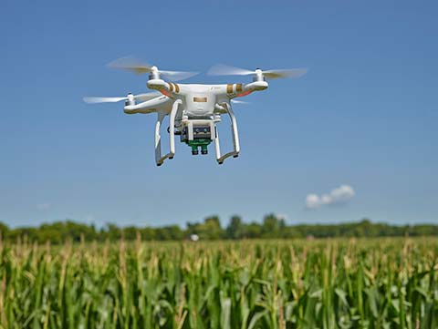
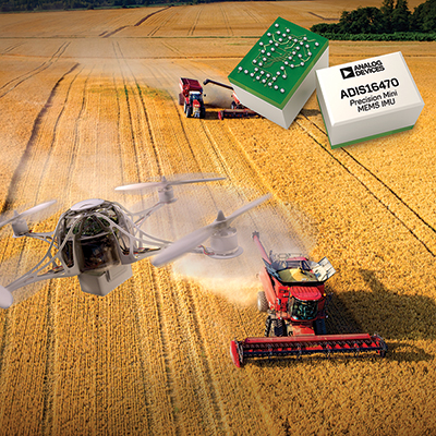
    Autonomous trucks and agricultural machines are already being used to make worker activities safer and more efficient. Drones can go to places that would otherwise be too expensive or dangerous for human workers to reach.

    Farmers use unmanned systems to survey and even spray crops; NGOs employ them to launch search and rescue operations in disaster zones; event coordinators monitor crowds with them at major musical festivals, and conservationists can track and protect endangered species better in risky areas with them.

    Advancements logo“For many years now, driven by our customers, we have been developing GNSS technology for industrial applications that is not only very accurate, but also reliable in the harshest of environments,” Van Hees said. “With the advent of drones and the interest in developing autonomous cars and trucks, this focus on secure GNSS is becoming ever more important. It’s exciting to see this technology affecting our daily lives more and more.”

    “UAVs and other autonomous systems have an enormous potential in aerial surveying, inspection, and a host of other industries,” said Rochelle Hyman, senior producer for the Advancements series. “The autonomous industry is important to Septentrio, and we look forward to sharing the innovative technologies that have been designed and developed by the company.”

    The Advancements series is an information-based educational show, targeting recent advances across a number of industries and economies. Featuring state-of-the-art solutions and important issues facing today’s consumers and business professionals, Advancements focuses on cutting-edge developments, and brings this information to the public with the vision to enlighten about how technology and innovation continue to transform our world.

  • University of Nottingham GNSS project to boost precision agriculture in Brazil

    Photo: University of Nottingham
    Photo: University of Nottingham

    The University of Nottingham is working with Brazilian and European Union (EU) partners to solve atmospheric interference problems that hamper satellite-based positioning in equatorial countries like Brazil.

    The research network will support the advancement of precision agriculture, which aims to make crop farming practices cheaper, greener and more efficient using satellite positioning and remote sensing.

    These technologies rely on GNSS (such as GPS and Galileo) to obtain centimeter-accurate coordinates on Earth. Farmers then use this real-time precise data to optimize fertilizer use, to steer driverless machinery and for soil mapping to maximize crop production in a bid to feed a rising world population.

    Despite its revolutionary potential, precision agriculture adoption rates in countries on equatorial regions such as Brazil are hindered by ionospheric scintillation in the Earth’s upper atmosphere.

    Ionospheric scintillation affects the integrity, availability and accuracy of satellite positioning. Specifically, it causes interference with the propagation of satellite signals as they pass through the ionosphere, making it difficult for GNSS receivers to lock onto satellites and track their signals. This results in not only large errors but sometimes to service outages.

    “The strong signal fluctuations that characterize ionospheric scintillation are caused by the irregular behavior of the ionosphere that is typical of the equatorial latitudes, affecting most of the Brazilian territory, hence the importance of the bilateral collaboration in the PEARL network,” said project leader Marcio Aquino from the Nottingham Geospatial Institute at the University.

    The PEARL network, which is funded by the European Commission’s INCOBRA project, aims to tackle this problem head on to ensure high-accuracy positioning by satellite is robust and achievable in real time in Brazil.

    “Solutions arising from the research will have a positive impact not only in Brazil but in the whole of Latin America, due to its geographical location near the equator and corresponding disruptive ionospheric effects,” Aquino said. “It could play a pivotal role in promoting the uptake of satellite-based positioning and the broad acceptance of the new EU system Galileo, paving the way for service implementation in other similarly affected parts of the world, such as southern China, India, Indonesia and Malaysia.”

    Research and industrial partners from both Europe and Brazil will come together on the seven-month initiative to develop strategies to map the causes of ionospheric scintillation and specialized algorithms to model and mitigate their effects on satellite-based positioning.

    These strategies will be part of a large Brazil-EU collaborative proposal to be submitted to the forthcoming H2020 SPACE-EGNSS call due out in October 2018.

    Network members include small to medium enterprises in Europe and Brazil that are keen to incorporate new solutions that will improve their satellite-based services.

    The PEARL network encompasses:

    1. University of Nottingham, UK; Sao Paulo State University and Universidade do Estado de Mato Grosso, Brazil.
    2. National Institute of Geophysics and Volcanology and SpacEarth Technology (an SME), Italy.
    3. Space Research Centre of Polish Academy of Sciences, Poland.
    4. Three small and medium-sized enterprises (SMEs): Geo++, Germany, and Alezi Teodolini and MC Engenharia Ltd, Brazil.

    The European Commission funds the INCOBRA project to increase and enhance Research and Innovation cooperation activities between Brazil and the European Union. PEARL is one of INCOBRA’s bilateral R&I cooperation networks, led by the University of Nottingham, addressing one of INCOBRA’s priority areas, namely bio-economy, food security and sustainable agriculture.

    According to the latest issue of the GSA GNSS market report (issue 5, 2017), revenue for GNSS device sales in precision agriculture will grow to nearly €3 billion by 2025, quadrupling from €750 million in 2013 (based on GNSS receiver sales to just this market segment).

  • Harxon smart antenna provides RTK positioning for agriculture

    Harxon smart antenna provides RTK positioning for agriculture

    Harxon Corporation is launching the single-frequency, multi-GNSS real-time-kinematic (RTK) enabled Smart Antenna TS300 series, designed for manual guidance and autosteer agriculture applications that benefit from scalable performance in positioning accuracy.

    The TS300 series smart antennas are designed for manual guidance and autosteer agriculture applications.
    (Photo: Harxon)

    The TS300 series is a multi-GNSS compatible system using GPS, GLONASS, BeiDou and Galileo for simultaneous satellite tracking to offer RTK positioning.

    It is able to track any visible satellites under challenging conditions, ensuring a stable signal quality with higher precision and reliable data. Farm tractors and machines can still receive a healthy signal when the sky is partially visible or there are obstructions around the farmland.

    The TS300 series features patented T-DIFF technology, providing smooth positioning and exceptional pass-to-pass accuracy. Its steady, smooth output is well suited for autosteer applications and helps the machines operate in a steady path. By reducing the impact of machine vibration during farming on complex landforms, T-DIFF technology ensures machine controlling and positioning accuracy at a centimeter level.

    Powered by the latest stand-alone algorithmic technology, the TS300 series can maintain the RTK positioning accuracy for a certain period when the RTK difference link is disconnected during machine operation. It guarantees that farm machines operate effectively and accurately under poor positioning conditions.

    Moreover, the TS300 series can output real-time tilt information for machines on rugged farmland. By optimizing the backend operation, it is convenient for users to improve positioning accuracy through a tilt compensation algorithm.

    The data links — 3G/4G modules, external/internal radio transmission modems and Bluetooth — of the TS300 series are designed as multiple selections as required, allowing customers flexible and convenient operation in different environmental conditions.

    Purpose-built for challenging environments, TS300 Series has built-in magnets to simplify mounting;  fixed mounting options are also available as 5/8-inch screws and M4 screws, providing convenient and quick installation. Its IP67 ruggedized enclosure works reliably in harsh environments and is designed for professional precision agriculture applications requiring high-precision RTK positioning.

  • Sentera adds elevation maps to AgVault platform

    Elevation variance maps are now available within the Sentera AgVault platform, offering agronomists, crop consultants and growers additional field insights.

    Topography and elevation data helps agriculture professionals increase operating efficiencies when building variable rate prescriptions, creating drainage or land-leveling plans, and designing subsurface drainage.

    Elevation maps are ordered within AgVault and are delivered as both a color-mapped topographic map image and a set of industry-standard shapefiles.

  • Raven grows precision ag facility in South Dakota

    Raven Industries has given South Dakota State University (SDSU) $5 million to establish a precision agriculture facility within the College of Agriculture and Biological Sciences on its main campus in Brookings, South Dakota.

    SDSU is the first U.S. land-grant university in the country to offer both a four-year degree and a minor in precision agriculture.

    The facility will be the nexus for innovation and collaboration across several disciplines, including engineering, agronomy, horticulture, mathematics and the decision sciences, according to SDSU President Barry Dunn.

    It will enhance innovation and the development of educational programs that will deliver applications to enable data-driven decisions in precision farming, ranching and conservation, as well as promote collaboration between faculty, students and industry experts.

  • Precision agriculture market to reach $5B in 2021

    The global market for precision agriculture solutions is forecast to grow from €2.2 billion ($2.6 billion) in 2016 at a compound annual growth rate (CAGR) of 13.6 percent to reach about €4.2 billion ($5 billion) in 2021, according to a research report from the market analyst firm Berg Insight.

    A set of technologies are applied in precision farming practices that are aimed at managing variations in the field to maximize yield, raise productivity and reduce consumption of agricultural inputs. While solutions such as auto-guidance and machine monitoring and control via onboard displays are mainstream technologies in the agricultural industry, telematics and variable rate technology (VRT) are still in the early stages of adoption.

    Interoperability between hardware and software solutions remains a challenge, although standardization initiatives led by organizations such as Agricultural Industry Electronics Foundation and AgGateway are making progress.

    Most major agricultural equipment manufacturers have initiatives related to precision agriculture, although strategies vary markedly. Leading vendors include agricultural equipment manufacturer Deere & Company, followed by the U.S.-based precision technology vendors Trimble, Topcon Positioning Systems, Raven Industries and Ag Leader Technology. Hexagon further holds a strong position in the positioning segment through its subsidiary NovAtel.

    A group of companies have emerged as leaders in the nascent market for in-field sensor systems. These include Davis Instruments, Pessl Instruments with its METOS brand, Semios, Hortau, AquaSpy and CropX.

  • Harxon releases frequency-hopping OEM modem

    Harxon has launched the HX-DU2017D, a frequency-hopping OEM modem designed to provide strong anti-jamming and signal receiving capability for complex data-intensive applications.

    HX-DU2017D is a miniature, dual-frequency, software-selectable 840 MHz and 900 MHz data link modem. It provides a power switching of 0.5 W, 1 W and 2 W, 20 ms/30 ms/40 ms/50 ms/ frequency hopping interval, and supports point-to-point, point-to-multipoint network.

    Its full duplex mode ensures secure data transferring and stable long-range communication, the company said.

    HX-DU2017D also provides short latency of data transmission and communication recovery in millisecond level.

    According to Harxon, HX-DU2017D allows fast and secure, simultaneous data communication for mission-critical applications, especially in the fields of precision agriculture and UAVs, including unmanned plant surveys, UAV plant protection and automatic mowers.

    It could easily be placed on a UAV with its extremely small footprint for tight OEM integration and design flexibility. Meanwhile, its frequency hopping transmission ensures the data security and flight stability.

  • Tersus kits include centimeter-accurate GNSS OEM RTK boards

    Tersus kits include centimeter-accurate GNSS OEM RTK boards

    Tersus GNSS Inc., a GNSS positioning solution provider, has introduced three new GNSS kits. The BX305, BX306 and BX316 HRS kits feature high-precision BX305, BX306 and BX316 GNSS RTK boards.

    The HRS kits consist of RTK receivers, GNSS antennas, RS05R radio station modems, radio station antennas, and related cables and converters.

    Embedded in the receivers are the Tersus RTK boards. They are compact-design, energy-efficient, centimeter-level accurate GNSS real-time kinematic (RTK) boards, bringing high-precision positioning accuracy to the market, the company said.

    Different from the standard BX305/306/316 GNSS kits, the new HRS versions are equipped with RS05R, lightweight and robust UHF, which is a rover radio solution for wireless application.

    It provides reliable data communication for demanding conditions that require a combination of stability, high performance and long-range operation.

    With complete components and accessories in the kits, they can be used in a variety of applications, such as unmanned aerial vehicle (UAVs), surveying, mapping, precision agriculture, construction engineering and deformation monitoring.

    Tersus GNSS BX316-HRS kit. (Photo: Tersus)
    Tersus GNSS BX316-HRS kit. (Photo: Tersus)
  • German ag society approves NovAtel receiver in automatic steering test

    A new report describes the benefits growers can experience using NovAtel’s TerraStar-C and TerraStar-L precise point positioning (PPP) technology with a SMART6-L GNSS receiver for automatic steering.

    The report, “DLG Test Report 6802, NovAtel SMART6L receiver PPP Automatic Steering Test,” was issued by the German Agricultural Society or Deutsche Landwirtschafts-Gesellschaft (DLG).

    DLG promotes technical and scientific progress in the agriculture and food sectors. Set up to test equipment and machinery, the DLG Test Center Machinery and Farm Inputs provide impartial information for practitioners.

    DLG awards a DLG-APPROVED quality mark to farm machinery that passes a limited test programme within a DLG usability test. Using a Fendt 828 Vario tractor, combined with the Fendt “VarioGuide RTK” steering system and the NovAtel SMART6-L receiver, steering accuracy was tested using both TerraStar-C and TerraStar-L correction services.

    NovAtel’s TerraStar-C correction service provides a 5 cm or less (95%) position accuracy, and TerraStar-L provides a 50 cm or less (95%) position accuracy with a 15-cm pass-to-pass accuracy. The DLG test is designed to measure steering accuracy under various conditions as part of the criteria to receive the DLG-APPROVED quality mark.

    The DLG test reported that NovAtel’s TerraStar-C correction service achieved 2-3 cm system steering accuracy on an A-B run on an even track at 8 km/h, and a 3.4 cm accuracy at 15 km/h. The long-term accuracy was reported at 3-4 cm over a 24-hour period. Also, the pass-to-pass error was less than 3 cm over the duration of an hour.

    The DLG test reported NovAtel’s TerraStar-L correction service at 17-18 cm accuracy during an hour A-B run on an even track at 8 km/h, and 10-11 cm accuracy on a contour run at 5 km/h. The pass-to-pass error remained below 15 cm for the duration of the tests.

    NovAtel’s SMART6-L was awarded the DLG-APPROVED quality mark after successfully completing the PPP autosteering test.

  • Analog Devices provides IMUs for autonomy

    Analog Devices has produced a series of five high-performance inertial measurement units (IMUs) for industrial applications that address the navigation- and safety-related needs of industrial applications in several emerging markets, while also reducing their system complexity and cost.

    The IMUs provide six-degree-of-freedom (DoF) sensing via triple-axis MEMS-based accelerometers and gyroscopes, and are focused on the demands of the industrial “internet of moving things” and its need for precise geolocation.

    The ADIS16470, ADIS16475 and ADIS16477 IMUs have standard surface mount assembly. The three models are optimized to provide a range of performance, cost and application-suitability needs.

    The ADIS16465 and ADIS16467 IMUs offer similar performance advantages in a more ruggedized enclosure option.

    Together, the products bring a previously unavailable performance-for-cost ratio to unmanned aerial vehicle (UAV) applications where designers have previously struggled with costly, risky and sub-par performance solutions from integrating consumer-grade sensors, which also fell short of reliability goals.

    These new IMUs bring the same benefits to autonomous machine applications in fields such as smart agriculture, where the demands of such rugged equipment previously forced a choice between cost-challenged, highest-grade sensors or performance-limited commercial sensors.

    All of the IMUs provide six degree-of-freedom (DoF) sensing via triple-axis MEMS-based accelerometers and gyroscopes, and are focused on the demands of the industrial “Internet of Moving Things” and its need for precise geolocation. Their performance allows systems to characterize motion accurately despite turbulence, vibration, wind, temperature and other environmental disturbances, resulting in more accurate navigation and guidance and instrument stabilization.

    The ADIS1646x and ADIS1647x IMUs are specifically designed to reject what are otherwise significant error sources, such as ‘g’-influence, cross-axis sensitivity and temperature and mechanical stress-related drifts.

  • DOT plans 3-year, 5+ participants for drone pilot program

    U.S. Secretary of Transportation Elaine Chao provided further details of the department’s new Drone Integration Pilot Program at a public event held Nov. 2 at the U.S. Department of Transportation (DOT) headquarters in Washington, D.C.

    Chao was joined by hundreds of drone operators, industry leaders, members of the public, law enforcement and first responders, and local, state, tribal and federal officials.

    The pilot program is designed to safely test and validate advanced operations through various partnerships across the country with oversight by the Federal Aviation Administration (FAA).

    A Federal Register notice lays out the timeframe, requirements, and goals of the new program, which will pair local, state, and tribal entities with private sector players in the drone industry to develop and deploy new operational concepts that are not currently in widespread use.

    The first step is for government officials to complete a Notice of Intent, signifying their intention to complete a full program application. Applicants will have 20 days to complete a Notice of Intent, followed by the requirement that they complete an application through the FAA/UAS Portal within 57 days. Within 180 days, initial program applicants who receive approval could begin deploying drones under the limitations coordinated and agreed to with the FAA. The program will last for three years.

    After evaluating all the applications, DOT will select a minimum of five partnerships. Full details of the Federal Register Notice and Application process can be found here.


    Webinars Scheduled. The FAA is hosting three webinars providing an overview of the program, application process and specific criteria and deadlines that must be met. The webinars will be held on the following times.

    • Friday, November 3 at 9:00 a.m. ET
    • Friday, November 3 at 3:00 p.m. ET
    • Monday, November 6 at 3:00 p.m. ET

    Registration is required to attend.


    The pilot program will evaluate a variety of operational concepts, including night operations, flights over people, flights beyond the pilot’s line of sight, package delivery, detect-and-avoid technologies, counter-UAS security operations, reliability and security of data links between pilot and aircraft, as well as local management of UAS operations subject to FAA oversight.

    Industries that could see immediate opportunities from the program include commerce, photography, emergency management, precision agriculture, and infrastructure inspections and monitoring.

    The program will help tackle the most significant challenges in integrating drones into the national airspace while reducing risks to public safety and security. The program is designed to provide greater regulatory certainty and stability to local governments and communities, UAS owners and operators who are accepted into the program.

    In less than a decade, the potential economic benefit of integrated unmanned aerial systems into the nation’s airspace is estimated to equal up to $82 billion and create up to 100,000 jobs,, according to AUVSI’s The Economic Impact of Unmanned Aircraft Systems.

    Chao told attendees the program application and deployment process will move quickly because a priority for DOT is encouraging innovation in the drone industry while maintaining safety for communities involved.

    “The drone pilot program will accelerate the safe integration of drones into our airspace by creating new partnerships between local governments, the FAA, and private drone operators,” Chao said. “These partnerships will allow local communities to experiment with new technologies like package delivery, emergency drone inspections, and more, on terms that work for them and in ways that support a unified and safe airspace.”

    “This program will put community and industry partnerships at the leading edge of aviation technology,” said FAA Administrator Michael P. Huerta. “What we learn through testing operational concepts in these communities will be invaluable and give us clarity on rules that ensure safety and continued innovation.”

    “More and more businesses and public safety providers are embracing UAS to expand and enhance their service offerings,” said Brian Wynne, president and CEO, Association for Unmanned Vehicle Systems International. “This growing demand illustrates a new renaissance in aviation and technology, which requires sustained collaboration and support by government at all levels.”

  • Harxon showcases GNSS products at Intergeo 2017

    Harxon is showcasing a series of GNSS antennas and wireless data-link modems at 2017 Intergeo, being held Sept. 26-28 in Berlin, Germany.

    The products aim to provide the user better industrial solutions in the fields of surveying and mapping, precision agriculture and unmanned aerial vehicles (UAVs).

    The Harxon D-Helix Antenna.

    D-Helix Antenna: The multi constellation antenna is capable of superior tracking signals from 4 satellite constellations, including GPS L1/L2 L-Band, GLONASS L1/L2, BDS B1/B2/B3 and Galileo. The innovative quadrifilar helix antenna design of low wind-resistance is ideal for aerial photographs, telemetry technology, disaster monitoring and security monitoring industries. Its 3.5dBi peak gain ensures exceptional low elevation tracking performance. The low noise figure enhanced transmission interference reduction and improve the signal quality.

    The Harxon GPS 1000 Survey Antenna.

    Survey Antenna GPS 1000: The all constellation GNSS antenna has passed the NGS certification, which receives GPS L1/L2/L5 L-Band, BDS B1/B2/B3, GLONASS L1/L2, Galileo E1/E2/E5a/E5b signals. It can be used in land survey, marine survey, channel survey and agriculture applications, with a consistent performance across the full bandwidth. GPS 1000 has high gain and wide beam width to ensure the signal receiving performance of satellite at the low elevation angle, and the phase center remains constant as the azimuth and elevation angle of the satellites change. The influence of measurement error can be minimized via the multi-feed design and embedded multi-path rejection board.

    Rover Radio HX-DU1603D: The high-speed, Bluetooth-enabled ruggedized UHF rover radio is designed for GNSS/RTK surveying and positioning. It ensures the data communication between 410MHz and 470 MHz in either 12.5KHz or 25 KHz channels. HX-DU1603D is equipped with a Bluetooth transceiver for wireless communications of external devices, features a 6800mAh rechargeable internal battery and configurable transmit power between 0.5W and 2W, also the IP67 waterproof capability allows outdoor long operational hours.

    Harxon Frequency Hopping Module HX-DU1018D/HX-DU2017D.

    Frequency Hopping Module HX-DU1018D/HX-DU2017D: The built-in frequency hopping transceiver modules are small size, light weight, low power consumption and strong resistance to disturbance. They provide a reliable, high speed and low latency data transmission, which are suitable for UAV flight control. These modules support a band range among 400MHz, 840MHz and 900MHz and long distance of communication. Besides, HX-DU1018D/HX-DU2017D can realize a switchover between air baud rate and serial port baud rate.

    Harxon Smart Antenna.

    Smart Antenna: It is a multi-functional GNSS product which is integrated by multi-frequency OEM antenna, OEM receiver and frequency hopping transceiver. Smart Antenna utilizes the dual anti-multipath antenna to receive stable GNSS signals under the bad-signal environment and precisely output the direct information with a centimeter-level positioning accuracy. The IP67 waterproof design allows the smart antenna for a long time outdoor operation.

    The Harxon H-RTK.

    H-RTK: H-RTK is for UAV positioning and navigation, which reaches the positioning accuracy to a centimeter level. It is integrated with positioning, height setting and heading functions to provide accurate, reliable solutions. H-RTK ensures the positioning accuracy to a centimeter level for a more stable flightpath. Also, it provides the reliable height information and solve the height-error problem to prevent air turbulence. H-RTK outputs precise navigation information with powerful magnetic disturbance resistance, it enables the flight reliability under a magnetic disturbance environment, and avoid security risks. The built-in anti-interference frequency hopping transceiver helps data transfer back to the base station, and supports the frequencies of 400 MHz, 840 MHz and 900 MHz.

    For more information,visit Harxon’s booth at Intergeo in Hall 4.1 booth C4.013.