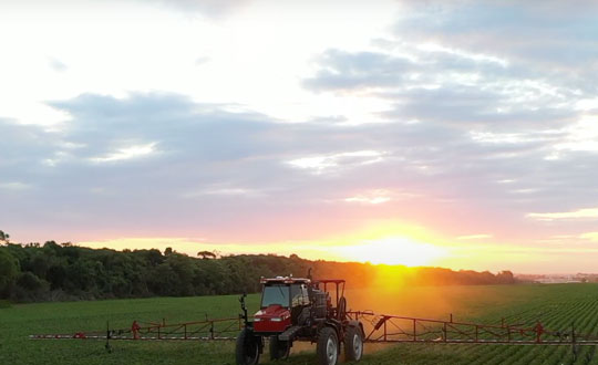
Precision agriculture — which promises to reduce inputs of water, fertilizers and pesticides by matching them to variations in soil conditions, thereby reducing environmental impacts, while increasing yields and productivity and reducing fuel consumption —has been around for a long time. This magazine published a few issues of a special supplement on the subject more than 20 years ago. In recent years, the convergence of enabling technologies — including improved satellite-based sensors, unmanned aerial vehicles, ground-based sensors, and GNSS corrections services — and greater demand has made agriculture one of the largest users of GNSS.
Compared to autonomous vehicles on public roads, autonomous tractors, sprayers, combines, and other farming equipment pose much lower safety concerns, because they need not deal with the vagaries of traffic, accidents and construction. They also are not subject to the kind of signal occultation and multipath that is the bane of GNSS navigation in urban canyons and, at least for now, they are not at significant risk of jamming or spoofing. However, they face other challenges, including severe roll and pitch due to bumpy terrain, some multipath from silos and other tall structures, occasional signal interference, occasional dense tree canopies, the requirement to maintain exact heading at very low speeds, the need to receive corrections over very large areas, complicated weather conditions (including rain, fog and dust clouds) and, like every other sector, cost constraints.
Despite this, guidance for farm vehicles must be consistently accurate at the decimeter-level, lest the machines damage the valuable crops that they are designed to service.
In the following articles, seven companies briefly describe their advancements in precision agriculture:
Automated steering systems have been widely deployed in advanced industrial countries and on large farms to improve agricultural productivity. However, technological and price barriers have constrained their wider adoption. Reliable RTK positioning and the expected accuracy of automated steering systems enable farmers to optimize their work efforts while reducing input costs and fuel consumption.
CHCNAV customer Niva LLC in Voronezh, Russia, was particularly interested in acquiring an automated steering system able to provide consistent high accuracy, even in scattered fields over long distances and with unstable coverage for GSM (the Global System for Mobile communication, a cell phone standard used in most of the world). Some systems Niva tested would lose GNSS RTK network correction signal reception while working in difficult terrain with gullies. A dual GNSS RTK correction source was therefore a key technical feature to ensure uninterrupted auto-steering operation in all terrain configurations.
The CHCNAV NX510 SE’s built-in connectivity modules include a 4G modem and an additional UHF radio module to allow farmers to work with RTK correction sources from local RTK networks or GNSS RTK base stations for no additional cost. As a result, the NX510 SE can receive GNSS RTK corrections from various GNSS network operators as well as from a local radio modem input to compensate for possible poor GSM coverage. The system’s combined GNSS+INS terrain-compensation technology ensures automated steering accuracy of 2.5 centimeters and offers excellent performance in ditching, seeding and harvesting applications.
Niva also wanted an auto-steering system that could be quickly and easily mounted on a variety of tractors and other farm vehicles at a price that would allow for rapid return on investment. The NX510 SE can be moved from one tractor to another in less than 40 minutes, as farming operations change. The software’s user interface for controlling field operations is designed for both experienced and casual users to allow even greater flexibility.
Intelligent navigation-based automation is redefining the farmer’s humble tractor to robotic status. This results in significantly faster field preparation and cropping and dramatically reduced labor costs.
Any autonomous vehicle requires the highest levels of navigational accuracy, control and safety. For farming applications, this typically means maintaining exact heading at very low speeds, often over bumpy terrain. These requirements make using the right navigational equipment critical to success. The key challenge is maintaining precise placement and movement of the tractor relative to crop rows and field boundaries. Failure to maintain precision can cause rows to be damaged or planted seedlings to be uprooted. The typical accuracy required for precision farming is position to within a decimeter (10 cm) — well beyond basic GNSS. This requires real-time kinematic (RTK) positioning and advanced signal processing.
Sabanto, a U.S.-based farming as a service (FaaS) start-up, was facing this exact challenge. The company needed a precise and reliable navigation solution for its fleet of driverless tractors deployed in a growing number of U.S. states, including Illinois, Iowa, Nebraska and Minnesota.
“The reliability of Advanced Navigation’s GNSS Compass gave us the peace of mind required to operate fully autonomously from Spring to Fall of 2020,” explained Craig Rupp, CEO of Sabanto.
Thanks to its dual-antenna GNSS and RTK corrections, the GNSS Compass can offer high-accuracy heading. Accurate position is maintained using real-time correction data, delivered from nearby ground base stations, resulting in near-centimeter accuracy under the most demanding conditions.
Furthermore, the GNSS Compass includes an integrated inertial navigation system (INS) to ensure consistent position accuracy of the tractor in the event of degraded or lost signals from GNSS satellites from heavy canopy or steep terrain. Roll, pitch and heading data also improve the stability of the autonomous platform over difficult terrain.
Sabanto engineers can now deploy and remotely monitor their fleet of autonomous tractors 24/7. Operators can simply pre-program the itinerary and field boundaries, as well as when to lift and lower tillers, resulting in the tractors planting up to two hectares (five acres) per hour.
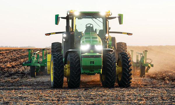
John Deere has revealed a fully autonomous tractor ready for large-scale production. The machine combines Deere’s existing 8R tractor, a TruSet-enabled chisel plow, a GPS-based guidance system, and new advanced technologies.
The autonomous tractor has six pairs of stereo cameras, which enable 360-degree obstacle detection and the calculation of distance. Images captured by the cameras are passed through a deep neural network that classifies each pixel in 100 milliseconds and determines whether the machine continues to move or stops, depending on whether an obstacle is detected. The autonomous tractor continuously checks its position relative to a geofence, ensuring it operates where it is supposed to, and is within less than an inch of accuracy.
John Deere Operations Center Mobile provides access to live video, images, data and metrics on a mobile device. Using the app, farmers can swipe from left to start the machine. While the tractor is working, the farmer can leave the field to focus on other tasks, while monitoring the machine’s status.
The app allows a farmer to adjust speed, depth and more. In the event of any job quality anomalies or machine health issues, farmers will be notified remotely and can make adjustments to optimize the performance of the machine.
Unveiled at the 2022 Consumer Electronics Show in Las Vegas on Jan. 4, the autonomous tractor will be available to farmers later this year.
By J. David Grossman Vice President of Regulatory Affairs Consumer Technology Association
This January, the annual Consumer Electronics Show (CES) — owned and produced by the Consumer Technology Association (CTA) — returned to Las Vegas. As the premier global platform for innovation, each year CES showcases the latest and greatest consumer technologies, from smartphones and wearables to self-driving trucks and electric cars.
GPS continues to play a central role in the technology we use daily. At CES, GPS-enabled technologies are found in nearly every product category, including 5G, internet of things (IoT), smart cities, vehicle tech and fitness wearables.
They are also among the CES 2022 Innovation Awards honorees, such as a connected bracelet that can alert emergency contacts and a robot that can identify the difference between crops and weeds.
How did GPS come to play such a critical role in devices as diverse as drones and smartphones?
Over the past 40 years, GPS has transformed from its origins as a military technology to one that no consumer or business can live without. During the 1990s, CTA members such as Panasonic and Sony pioneered commercially available GPS receivers.
At CES 1998, Garmin introduced StreetPilot, described as “one of the first practical and affordable GPS-based road navigation devices” and paved the way for huge growth in the consumer GPS market.
By the 2000s, GPS was no longer just a stand-alone technology. Following new Federal Communications Commission requirements, GPS-enabled smartphones opened the door for all-in-one devices. These products could deliver turn-by-turn navigation or identify the location of a lost or stolen device. In more recent applications, GPS technology provides the foundation for ever-more-complex mobile applications.
Opening of the 2022 Consumer Electronic Show. (Photo: Consumer Technology Association)
Foundational Technology
The evolution of GPS reflects a broader industry trend: innovators integrate foundational technology into successive generations of products, spurring development of new products and services. We’ve seen the same pattern play out for Wi-Fi, Bluetooth and Near Field Communication (NFC), which enables the latest tap-to-pay technologies. Hundreds of companies simply would not exist without free, global access to GPS signals!
With GPS, ridesharing companies such as Lyft match drivers and passengers, lead drivers to a precise pick-up location, and chart out a safe and efficient driving route. GPS-integrated smartwatches allow runners and cyclists to easily track pace and distance, a huge boon for many of us in the pandemic era. Closer to home, GPS-enabled pet collars help families keep tabs on their furry friends.
Revolutionary
Beyond the technology we use daily, GPS technology is also revolutionizing such industries as agriculture. Thanks largely to GPS, centuries-old businesses are now technology companies. For instance, John Deere leveraged its 185-year history of building tractors and combines GPS with other location technologies to steer semi-autonomous tractors with centimeter accuracy. In addition to the time and efficiency benefits for farmers, technologies like these support sustainable agriculture by reducing the use of pesticides, water, seed and fertilizer.
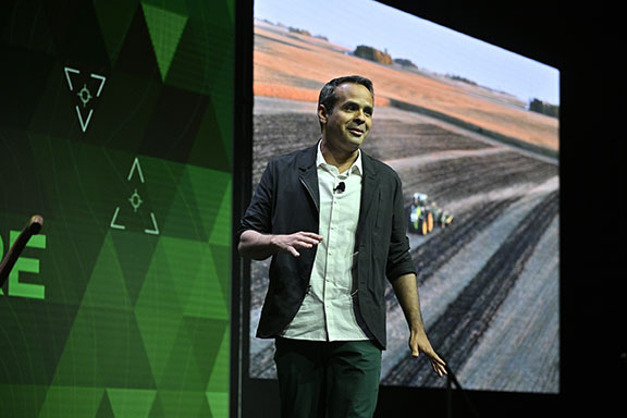
John Deere held a Media Days press conference at Mandalay Bay during CES 2022. (Photo: Consumer Technology Association)
The success of GPS is important for our industry’s success, and I am proud of the role GPS plays in everyday life. Modernization of GPS, supported by the U.S. government and industry, will enhance the accuracy, reliability and resiliency of the technology, which in turn will ensure GPS remains central to the innovation economy.
Trimble’s new GNSS base station gives users improved satellite tracking and remote operation for civil construction, geospatial and agriculture applications
Photo: Trimble
Trimble has introduced the Trimble R750 GNSS modular receiver, a connected base station for use in civil construction, geospatial and agricultural applications. The R750 provides high-accuracy base station performance, giving contractors, surveyors and farmers more reliable and precise positioning in the field.
The R750 can be used to broadcast real-time kinematic (RTK) corrections for a wide range of applications, including seismic surveying, monitoring, civil construction, precision agriculture and more. Access to all available satellite signals provides improved performance and reliability when used with a Trimble ProPoint GNSS rover. ProPoint gives users improved performance in challenging GNSS conditions, with improved signal management.
Featuring a built-in LTE modem, the R750 can provide corrections via the internet, making it easier to extend the range of a base station anywhere with cellular coverage. The built-in modem also provides remote access and management, delivery of email alerts and notifications, and data transfer capabilities between the field and the office.
“The R750 delivers significantly improved satellite tracking and connectivity, while also providing a vastly improved user experience,” said Scott Crozier, vice president of Trimble Construction Field Solutions. “The ability to manage the base station remotely, and to receive status notifications about the unit while in the office reduces downtime and the need to travel to the site. The new Trimble R750 is a game changer, especially for users who manage base stations in remote locations.”
For monitoring applications, the R750 provides precision capabilities for construction and geospatial customers deploying automated systems. Combined with Trimble 4D Control real-time monitoring software, users can capture high-frequency 3D positions for alarming and reporting on movement. The R750 offers multiple communication methods that provide flexibility for customers on how they deploy their monitoring system.
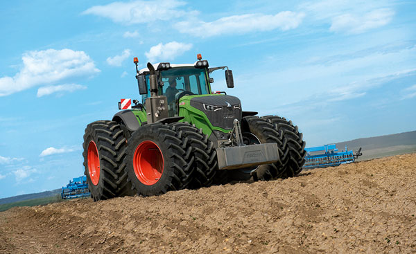
New Inmarsat research reveals a rapid increase in levels of industrial IoT maturity in 2021, with agricultural businesses accelerating IoT adoption in response to COVID-19
Research by Inmarsat, a global mobile satellite communications company, reveals a rapid increase in the maturity level of the industrial internet of things (IoT) across the agricultural sector since the start of the COVID-19 pandemic, with 86% of ag business accelerating or intending to accelerate deployment.
Respondents in the report, “Industrial IoT in the Time of COVID-19,” include crop producers, OEMs, service providers and livestock businesses, who report that COVID-19 demonstrated the importance of IoT to their businesses.
According to the research, adoption has seen huge progress from 2020 to 2021, with automation and cost savings the greatest drivers. Four-fifths (80%) of agricultural respondents have now fully deployed at least one IoT project, with 53% having achieved this in the 12-month period from the second quarter of 2020. Of the remaining 20% of agricultural respondents that have not yet adopted IoT in any form, all of them are either currently trialing it, or plan to deploy or trial at least one IoT project in the next two years.
Chart: Inmarsat
A further 86% of agricultural respondents indicated they have or they intend to accelerate the adoption of IoT in response to challenges related to COVID-19. This figure includes 46% who have already accelerated IoT adoption to respond to COVID-19, versus 29% who will accelerate over the next 12 months and 11% who will accelerate beyond the next 12 months.
The 46% that have already accelerated IoT adoption are less likely to state that COVID-19 has negatively impacted their ability to operate, demonstrating a link between IoT and business continuity during the pandemic. Additionally, more than half (60%) of respondents in the sector indicated that business and operational challenges related to COVID-19 have underlined the importance of IoT.
“We have seen agricultural producers take on more and more solutions that allow them to operate remotely, from autonomous irrigation control to the latest precision farming technologies, demonstrating increased faith in the technology,” said Steven Tompkins, Director of Market Development at Inmarsat.
As part of the research, Inmarsat is offering businesses the opportunity to measure their IoT readiness compared to the respondents in the survey, using their free IoT maturity tool.
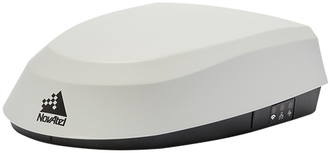
Fendt machines in North America, Europe and the Middle East equipped with Fendt Guide guidance systems powered by Fuse Smart Farming now come with NovAtel’s SMART7 GNSS receiver as the default configuration choice.
“We have been working with NovAtel for years, and their support and willingness to adapt to meet our needs makes them the key GNSS receiver supplier for our Fendt Guide guidance system,” said Bernhard Schmitz, director, FendtONE Market Readiness and Agronomy EME. “They are easy to work with and have high-quality products that integrate seamlessly into our machines.”
The SMART7 combines a powerful GNSS receiver with a precision antenna in a durable, all-in-one enclosure designed to stand up to the vibration, weather and temperature demands of harsh agricultural environments. Delivering exceptional positioning, the SMART7 is optimized to succeed in demanding agriculture and off-road applications.
Photo: NovAtel
The SMART7 uses multi L-band tracking to access TerraStar Correction Services globally, bringing repeatable centimeter-level accuracy to any application, anywhere in the world. Access to multi-frequency GPS, GLONASS, BeiDou, Galileo and QZSS signals provides better satellite availability in challenging environments.
Resiliency to radio frequency interference is ingrained in NovAtel’s hardware designs, and the company’s Interference Toolkit firmware suite provides detection and additional protection from any potential intentional or unintentional interference.
Powered by NovAtel GNSS+INS technology, the SMART7 uses an optional integrated inertial measurement unit (IMU) to provide continuous 3D positioning, velocity and roll/pitch/azimuth for deeper integration with vehicle guidance and steering systems. Additional optional features on the SMART7 include Wi-Fi and Ethernet for remote connectivity and monitoring.
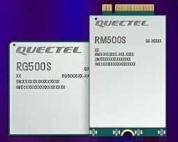
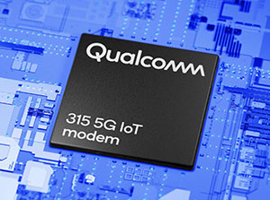
Quectel Wireless Solutions, a global supplier of modules for the internet of things (IoT), has announced the release of two new 5G New Radio (NR) module series, the RG500S and RM500S.
Based on the new Qualcomm 315 5G IoT Modem-RF System, both modules can support customers in building dedicated 5G devices for a variety of verticals including industrial IoT, retail, smart energy, private 5G networks, and many others.
The RG500S and RM500S both integrate a multi-constellation GNSS receiver, which simplifies the product design and provides accurate positioning services for users.
Utilizing the powerful Qualcomm 315 5G IoT modem, the RG500S and RM500S support extended-life software maintenance, helping create long-lasting IoT devices for the duration of their life span. Offering seamless integration, the RM500S is pin-to-pin compatible with Quectel’s LTE Cat 4 module EM05, Cat 6 module EM06, Cat 12 modules EM12-G/EM12xR-GL, Cat 16 module EM160R-GL and 5G module RM500Q, which provides more competitive 5G solutions to the IoT market. These features will help accelerate the 5G IoT market in the industrial and consumer IoT segments with use cases across robotics, automation, intelligent manufacturing, energy distribution, precision agriculture, construction, and mining.
Photo: Quectel
The RG500S and RM500S modules support 5G NR sub-6GHz bands in stand-alone mode offering backward compatibility with LTE networks. With network slicing in stand-alone mode, the two modules are able to offer end-to-end traffic isolation for critical traffic, guaranteed data rates and bandwidth, and lower latency than in non-standalone mode, which meets the demands of ultra-reliability and service-level agreements of typical industrial and enterprise scenarios.
The two modules are embedded with rich interfaces and incorporate high-speed USB 3.0/3.1, PCIe 3.0, U(SIM), RGMII and more, making them suitable for diversified industrial and consumer 5G applications such as industrial routers, robots, automation, intelligent manufacturing, smart cities, energy distribution, precision agriculture, construction and mining.
“Quectel has long been collaborating with Qualcomm Technologies to support the enablement of the 5G market in IoT,” said Patrick Qian, CEO, Quectel. “Based on the latest Qualcomm 315 5G IoT modem, the RG500S and RM500S are able to offer greater possibilities for the industrial and commercial IoT verticals. Features such as high performance and low latency as well as extended life software maintenance address the existing IoT market needs and can power a range of new 5G IoT use cases.”
“The Qualcomm 315 5G IoT modem solution was introduced to stimulate and scale the 5G IoT industry and enable the transitions needed to make 5G for IoT a reality. This solution is pin-to-pin compatible with legacy modules, which can accelerate device development and commercialization and promote growth and expansion in the 5G IoT industry. Integrating Qualcomm Technologies’ purpose-built modem into Quectel’s RG500S and RM500S modules will help deliver 5G to the IoT industry across industrial and enterprise applications,” said Jeffery Torrance, senior vice president, product management, Qualcomm Technologies.
Aceinna and Point One Navigation launch hardware and software platform for precise positioning in agriculture, construction, mapping, surveying, robotics and trucking
The OpenARC positioning service is now commercially available. OpenARC is a precise-positioning hardware and software platform for system integration of GNSS corrections with high-performance inertial navigation system (INS) and real-time kinematic (RTK) hardware.
OpenARC is offered by Aceinna, a developer of inertial-based guidance and navigation systems, and powered by Point One Navigation.
With an RTK positioning engine and GNSS corrections delivered from a ground-based network of secure base stations, OpenARC will reliably improve position accuracy for autonomous vehicles to centimeter-level accuracy. The platform combines Point One’s Polaris GNSS correction service with Aceinna’s OpenRTK330 hardware and software solution for developers of autonomous systems in trucking, precision agriculture, construction, mapping, surveying and robotics.
OpenARC provides high-precision positioning and localization applications, enabling centimeter-level accuracy for challenging tasks such as lane keeping, precision agricultural guidance, and UAV landing maneuvers.
OpenARC is integrated into the OpenRTK330LI navigation module to provide a secure, vertically integrated and easy-to-use positioning platform. OpenARC is very scalable, supporting single-unit installations and high-volume deployments.
Point One’s proprietary Polaris GNSS cloud correction service delivers superior station density in areas where operators need it the most, including urban centers and suburban surrounding areas, enabling cold convergence times of under 10 seconds.
Polaris provides continuous position monitoring and tracks all modern satellite constellations. Its base-station technology includes advanced anti-jam, interference mitigation, security and integrity monitoring. Its architecture allows for GNSS corrections in RTK or state space representation (SSR) configuration. Its open-source interfaces are compatible with multiple receivers and chipsets, and the service is compatible with any NTRIP/RTCM3 compliant receiver.
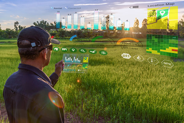
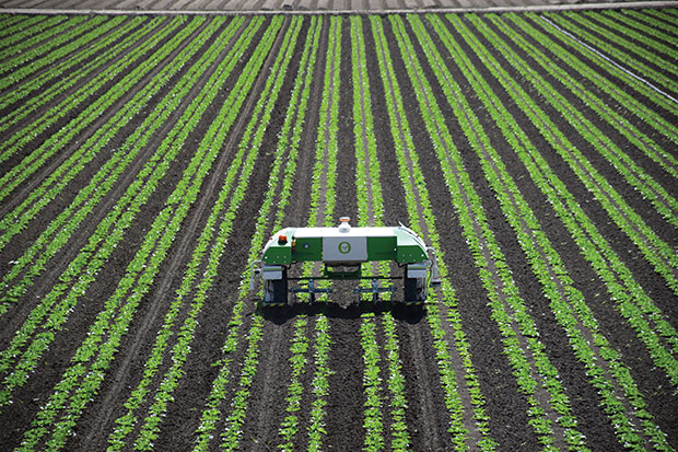
Centimeter-level positioning and high-accuracy orientation of machinery enable automation of many construction, mining and farming tasks, and take them one step closer to being performed by autonomous machines. Machine control increases jobsite safety, operational efficiency and productivity.
Using data from GNSS satellites, total stations and 3D models, machine-control hardware and software solutions determine a machine’s current position on the Earth and compare it with the desired design surface, mining task or cultivation technique. They also monitor and sometimes control the position and orientation of implements — such as blades, buckets and seeders — with respect to the machine. By talking directly to the machine’s hydraulics, machine automation shifts responsibility for accuracy and speed from the operator to the technology.
On construction sites, automation guides motor graders, excavators, dozers and other heavy machines, making operations easier to manage. This makes contractors more productive and experienced operators more efficient. With this technology, less experienced operators are able to take on more complex tasks, and all operators become more accurate. Machine automation also increases the capabilities of the machines themselves, so that excavators and compact machines are now doing finish grade work once reserved for larger and more expensive dozers.
Operators in the cab and engineers and supervisors at their desks can control and monitor progress in real time, with views of the whole layout as well as specific slopes, roads, ditches and other elements, including those under water.
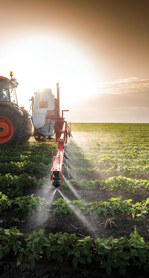
Using GNSS guidance to aid application of fertilizer, pesticides and herbicides saves time and money. (Photo: Septentrio)
About half of all motor graders and a third of all dozers use positioning sensors and a display to provide operators with the position of the blade with reference to the target grade. A typical machine control set-up consists of a GNSS receiver and a display (jointly referred to as a “cab kit”) and inertial measurement units (IMUs) on the blades and other implements.
From the display, the operator loads a project design, which tells the system the cut, fill and other design information it needs. The operator then chooses a lane and may choose a vertical offset, which temporarily adjusts the design grade, making it possible to accomplish the work in steps, from rough to finish grading. Operators can also record points and scan a pavement in real time as they repair it.
While used by the construction industry on earthworks equipment since the late 1990s, machine control has recently benefited from:
The increase in the number of GNSS signals available, particularly on the new L5 frequency
IMUs, which measure blade movements with respect to the machine 100 times per second, one order of magnitude more than non-IMU grade-control systems
The growing availability of continuously operating reference stations (CORS) and other GPS networks, which eliminate the need to set up a base
New mastless systems, which integrate a receiver into the top of the cab and connect it wirelessly with IMUs to orient the blade, obviating the need to install a long mast pole on the blade and connect it by cable to the receiver and improving safety, visibility and equipment durability
New interfaces designed to be as easy to use as a cell phone, shortening the operators’ learning curve.
While these developments are hastening the advent of autonomous construction, mining and farming machines, remaining barriers to this vision include hardware and software issues as well as questions of data exchange, legal liability and operator training — issues analogous to those facing the development of autonomous cars and trucks.
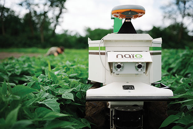
The DINO is a one-ton farming robot made by NAIO Technologies that operates autonomously using GNSS positioning and maps for navigation. Of the 170 NAIO farming robots currently in operation, about 30% are DINOs, which are typically used on large farms.
In 2016, NAIO and Septentrio, a manufacturer of industrial high-end GNSS technologies, began to research the integration of full GNSS solutions into NAIO’s robots.
Today, the DINO carries a Septentrio NR3, consisting of a GNSS receiver and antenna in a single housing, which provides it with RTK centimeter-level positioning accuracy. Farmers can use the NR3 to map their fields, then attach it to the DINO to guide it.
The DINO automates weeding within complex and quickly changing environments. NAIO plans to soon add seeding and fertilization to its robot’s capabilities.
To operate reliably in the narrow lanes between crops, the DINO requires an accurate GNSS receiver with strong resistance to multipath and jamming.
The safety of field hands and the protection of the crops also require the receiver to have good integrity, which is a measure of the trust that can be placed in the correctness of the information it supplies. Accuracy, robustness, and integrity are all strong suits of Septentrio’s NR3.
While the DINO mostly operates continuously, it sometimes stops to avoid animals or humans, or for other safety reasons. A major advantage of the NR3 and other sensors that NAIO is using, is that they enable the robot to perform cold-starts very rapidly and with a stable heading.
Machine control, guidance and automation defined
Using GNSS guidance to aid application of fertilizer, pesticides and herbicides saves time and money. (Photo: fotokostic/iStock/Getty Images Plus/Getty Images)
The terms machine control, machine guidance and machine automation are not interchangeable.
Machine control is a generic term that refers to the integration of positioning tools into a construction, mining or farming machine to determine its position on the Earth and relative to a desired design surface, mining task or cultivation technique.
Within machine control, machine guidancesystems display these data in the cab — assisting the machine’s operator in steering the machine and in maneuvering its implements to shape the ground, mine minerals, plant seeds or perform other related tasks — while machine automation systems directly steer the machine, achieving greater levels of precision than human operators could. The term automated machine guidance (AMG) is sometimes also used.
While farmers work on growing and gathering their crops in the most efficient ways possible, other people key to the agriculture industry are hunters. These hunters seek the most efficient and groundbreaking ways to carry out such tasks as plowing, planting, fertilizing, weeding and, finally, gathering.
This month, among other machine-control applications, we focus on using GNSS technology to improve agricultural efficiency. According to research firm MarketsandMarkets, the precision farming market is estimated to be $7 billion in 2020 and is projected to reach $12.8 billion by 2025, growing 12.7% every year between.
Factors driving growth include increasing farm mechanization in developing countries, rising labor costs, increasing strain on the global food supply, substantial cost savings associated with smart farming techniques, and government initiatives to adopt modern agricultural techniques. For a look at today’s technology, see our cover story.
James Litton
Sadly, this month we also say goodbye to a pioneer in the precision ag field. James D. Litton founded NavCom Technology in 1995 with three partners, Ron Hatch, KT Woo and Jalal Alisobhani.
Litton’s career began at Magnavox in the early days of GPS, where he worked on the original proposal for GPS Phase I and helped develop new and advanced commercial navigation and survey receivers for both the Navy’s TRANSIT system and the Air Force’s GPS.
In 1992, Litton opened a consulting firm, and in 1994, he and his partners founded NavCom with Litton as CEO. Under contract, NavCom developed a single-frequency WAAS-capable GPS aircraft navigation receiver.
“His work transformed agriculture into a data-driven, technological industry.” — Brad Parkinson
NavCom also began a relationship with Deere & Company, supporting more efficient and productive agriculture. This relationship was so successful that Deere, which recognized GNSS tech as a smart investment, purchased NavCom in 1999.
Litton continued to lead the company and serve as part of Deere’s senior management team for eight more years.
Among his many contributions to the GNSS field, his impact on global agriculture might well have been his greatest, according to Brad Parkinson, the original chief architect for GPS and Editorial Advisory Board member.
“His work transformed agriculture into a data-driven, technological industry that was incredibly more efficient,” Parkinson said. “The cost savings and increases in productivity have impacted billions around the world.”
Litton also authored several articles for GPS World.