Tag: precision agriculture

  • Hemisphere GNSS provides do-it-yourself installation

    Hemisphere GNSS provides do-it-yourself installation

    AC110 application controller. (photo: Hemisphere GNSS)
    AC110 application controller. (Photo: Hemisphere GNSS)

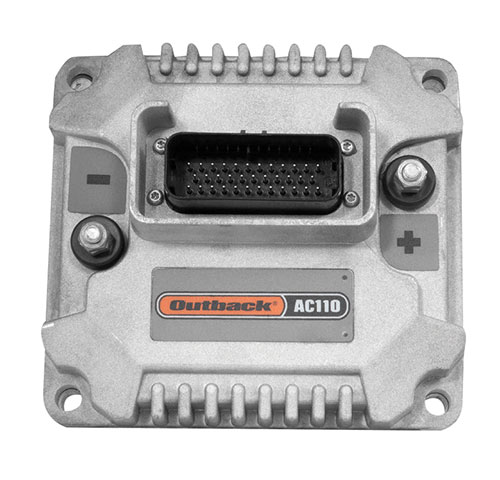
    Hemisphere GNSS is primarily known for its Outback brand. It includes the Outback Guidance autosteering solution (a smart antenna that combines a GNSS receiver and a GNSS antenna in a single housing), the ESI² electric wheel that steers a tractor, the AC110 application controller that controls the rate and section, and the Rebel terminal in the cab that runs the application software. Hemisphere’s A222 smart antenna is being used by Raven and AgJunction.

    “We put these product components together in different configurations for the solutions,” said Miles Ware, the company’s marketing director. “We support hundreds of tractor models with this type of solution or using our terminal for a steer-ready integration, in which you just plug our terminal and steering controller right into the tractor’s interface and it sends the commands to the hydraulic steering.”

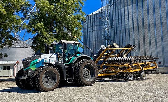
    One of the challenges with guidance for precision agriculture is that people think that tractors always operate in a wide-open field, where satellite availability is not a problem, Wares explained. That is often not true, however, due to obstructions such as tree canopies.

    That is particularly an issue when using real-time kinematic (RTK) corrections for planting and seeding, which require a couple of centimeters of cross-track accuracy. Farmers want to quickly acquire a line and then maintain it. “All those functions are immediately impacted if you have challenges in the positioning solution,” Wares said.

    The Outback Guidance brand offers three different packages:

    • Atlas Broad-Acre farming for uses that require sub-meter accuracy, such as large seeders or fertilizer sprayers;
    • Atlas H10 or the Atlas Row-Crop Service for row crop-level accuracy, for example to plant corn; and
    • a sub-inch package that uses RTK technology for automated steering.

    One of the key benefits of automated steering is less fatigue for the driver, explained Roland Moelder, Hemisphere GNSS’ product manager for Agriculture Technology. “Especially when it is dark, it is very hard to do a proper job, minimizing the overlap but also not leaving gaps.”

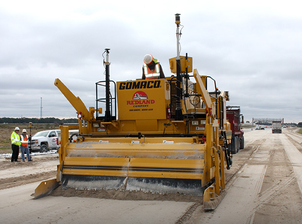
    Automated steering also enables farming practices that require more accurate driving than is humanly possible, such as for strip till, the practice of driving on exactly the same lines year after year.

    Application-Guided Planting. Hemisphere’s devices can monitor, control and manipulate implements that use ISOBUS standard communications. Operators can select the attributes of their planter in the application; the display will then show them the planter’s location and which sections are active.

    For example, if they are approaching a section of the field that they already planted, the AC110 control will turn off some of the seeding heads during the turn.

    The same applies to spraying. The product automates the section control and coordinates it with the centimeter-accuracy steering.

    Hemisphere’s solution is built around an after-market, so that farmers are not forced to buy the latest and greatest piece of equipment to take advantage of its technology, Wares added. “They can take a lot of their existing equipment, on which they may have already achieved the return on investment or are close to it, and add our solution.”

    These two plots show how signals from additional GNSS constellations improve mapping. The map on the left is based on only GPS and GLONASS signals, which is typical. The one on the right is improved by adding signals from Galileo and BeiDou. In both images, the green lines are converged/fixed. In the image on the left, the yellow lines are converging/floating. (Images: Hemisphere GNSS)
    These two plots show how signals from additional GNSS constellations improve mapping. The map on the left is based on only GPS and GLONASS signals, which is typical. The one on the right is improved by adding signals from Galileo and BeiDou. In both images, the green lines are converged/fixed. In the image on the left, the yellow lines are converging/floating. (Images: Hemisphere GNSS)

    Do-It-Yourself. To facilitate the installation of its smart antenna, Hemisphere works with all the manufacturers of tractors, sprayers, combines and other field vehicles to make kits that enable customers to perform the installation themselves.

    “We take pride in that,” Moelder said, adding that some installations are done by dealers. The ESI2 electric wheel solution is a much easier installation than a hydraulic one. “We also support a list of ‘steer-ready’ vehicle installation kits, which are kits that utilize pre-existing components that are already on the OEM machine, where we just plug-and-play components and make it very easy for the customer to use what is already there.”

    Historically, many of these solutions were built around adding hydraulic valves to a tractor, which was a lot of work. “Now, we can communicate directly to the smart valves on steer-ready models,” Wares said, “and it does not require, say, extra hoses, valves and brackets.” Electric wheels, which have tens of thousands of teeth, can manipulate the hydraulics with even finer resolution and are much easier to install than hydraulic valves.

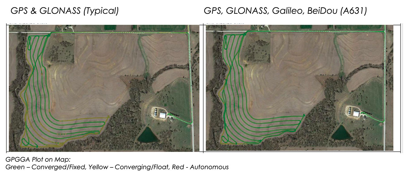
    Multi-GNSS technology has a big value for precision agriculture, Moelder said. He cited Hemisphere’s new S631 smart antenna, which tracks all available signals, greatly speeding convergence and maintaining it much better in challenging environments.

    Unlike other corrections systems, Hemisphere’s Atlas uses all the available GNSS constellations. “If you are not taking advantage of them, you are really missing out,” said Wares. You cannot take full advantage of a multi-GNSS receiver without multi-GNSS corrections, he pointed out.

  • Harxon introduces TS112 family for agricultural machine autosteering

    Harxon introduces TS112 family for agricultural machine autosteering

    Harxon TS112 smart antenna family. (Photo: Harxon)
    Harxon TS112 smart antenna family. (Photo: Harxon)

    Harxon has introduced its TS112 family of smart antennas for demanding applications such as agricultural machine autosteering systems that require high positioning-accuracy. Harxon made the introduction in a virtual meeting on Jan. 13 from Shenzhen.

    The TS112 family features Harxon’s latest GNSS positioning technology and offers scalable positioning solutions with increased GNSS availability, reliability and accuracy.

    Each of the three models embed Harxon X-Survey four-in-one technology. The high-gain and wide beamwidth multi-constellation GNSS antenna integrates 4G, Bluetooth and Wi-Fi in one compact unit. They feature multi-point feeding technology, ensuring high phase-center stability and real-time kinematic (RTK) centimeter-level positioning accuracy.

    TS112 Smart Antenna Family Specifications. (Chart: Harxon)
    TS112 Smart Antenna Family Specifications. (Chart: Harxon)

    The TS112SE, as the most affordable solution of the three, provides flexible positioning solutions via standalone positioning or dual-frequency precise point positioning (PPP) with accuracy from sub-meter to centimeter level while using Sapcorda’s SAPA (Safe and Precise Augmentation Service). Its comprehensive support and L-band augmentation service ensure solid satellite tracking without signal outage even in difficult terrains or problematic environmental conditions.

    SAPA works as a reliable alternative economical positioning option with wide service coverage in the application environment that has poor LTE network coverage.

    The TS112 integrates a high-precision GNSS module with multi-band GNSS receiver and Harxon’s four-in-one multifunctional GNSS antenna in a compact housing. It supports dual-frequency multi-constellations for consistent and robust satellite signal tracking and delivers RTK-level positioning accuracy for precision agriculture equipment and machine control. It offers a 4G and UHF radio modem for flexible correction transmission as well as wireless Bluetooth technology for easy connectivity in the field.

    The TS112 PRO employs a future-ready Hexagon OEM GNSS module, offering precise positioning and advanced interference mitigation for space constrained applications and challenging environments.

    With centimeter-level positioning utilizing TerraStar satellite-delivered correction services, Harxon’s TS112 PRO ensures globally available, high performance positioning without the need for network infrastructure. Harxon’s TS112 PRO also support NTRIP service, so in application environments where using a base station is not feasible, the NTRIP differential corrections could be transmitted to a rover using 4G networks and enable users reaching ultimate centimeter level positioning accuracy.

    The TS112 PRO also features Hexagon’s Glide smooth positioning that offers superior pass-to-pass accuracy down to 20 centimeters for applications where relative positioning is critical.

    All models in the TS112 family support Harxon Slide technology to provide smooth positioning and exceptional linear accuracy so that the guiding system can continue to guide during satellite signal outages or in challenging environments.

    The newly released family also support Harxon terrain compensation algorithm that is capable of correcting deviations that caused by vehicle’s roll and pitch while working on uneven grounds or slopes. It helps users increase operational efficiency and saving cost in the field.

    Adopting ruggedized and IP67 standard housing, the TS112 family equip NMEA0183 and NMEA2000 CAN ports, RS-232 serial ports for easy connectivity.

  • Topcon Agriculture offers enhanced in-cab displays

    Topcon Agriculture offers enhanced in-cab displays

    Photo: Topcon
    Photo: Topcon

    Topcon Agriculture has released new in-cab displays — XD and XD+ touchscreen consoles — with an upgraded user interface experience, Horizon 5.

    With Topcon Agriculture Platform (TAP) integration, the consoles are designed to provide farmers with full-feature customization to optimize their investment by paying only for capabilities they need.

    “As a farmer’s needs grow, often times they’ve had to use multiple single-function consoles. In recent years, Topcon has offered the X family of consoles designed with all-in-one capability to resolve this issue, reducing clutter, improving setup, updates, support, and reducing overall hardware costs,” said Brian Sorbe, vice president of global production solutions. “Now with the additions to the series, Topcon is further simplifying cab control and it’s a modular approach with future needs in mind for each unique farming operation.”

    Farmers can immediately take advantage of off-the-shelf features such as basic guidance, task management, universal ISO-UT compatibility, and TAP Fields to manage farm data. Additional features are unlockable for use with the full range of Topcon sensors and application control technology.

    “TAP is a digital farm management system and it’s a way for a farmer to organize, visualize and make decisions and it begins with the touch of the console in the cab, and now with the new user interface and digital system all integrated, it will be simpler and easier to setup and get to work,” Sorbe said.

    The new consoles are designed to be ready for any application such as soil preparation, seeding, crop care, harvest, weighing and data services.

    The consoles are available in 7-inch and 12.1-inch screens, including new day and night modes.

  • Smart agriculture market estimated to reach $29M by 2027

    Smart agriculture market estimated to reach $29M by 2027

    Photo: artiemedvedev/iStock / Getty Images Plus/Getty Images
    Photo: artiemedvedev/iStock / Getty Images Plus/Getty Images

    The global smart agriculture market size was valued at $16,747.7 million in 2019 and is estimated to reach $29,234.6 million by 2027, with a CAGR of 9.7% from 2021 to 2027, according to Valuates Reports.

    The market is expected to rise as a result of rising population, increasing strain on the food supply system, the growing use of new technology in agricultural products and farmers’ growing focus on tracking livestock.

    According to the report, the global competition between players will be increased by new players joining the global smart agriculture market, which will in turn increase advancements in technology. Top companies in the smart agriculture market include Trimble, Deere & Co., Topcon Positioning Systems, DeLaval, AgEagle Aerial Systems, Afimilk, Raven Industries, Ag Junction, AGCO Corporation and GEA Group, the report said.

    Current trends influencing smart agriculture market size include the growing adoption of automation and control systems, such as GPS/GNSS receivers, irrigation controllers, and guidance and steering systems, has created a new approach to farming practices. The report said it also expects growing investment, R&D spending on agricultural technology and increased popularity of land-based recirculating aquaculture systems to fuel market growth.

    The report also touched on COVID-19’s impact on the smart agriculture market, noting the market is expected to see a marginal fall in 2020 as movement restrictions and lockdowns have led to supply chain disruptions.

    Despite this, the precision farming segment held the largest market share in 2019 and is expected to retain its dominance during the forecast period, the report said. North America is expected to hold the largest smart agriculture market share during the forecast period, and Asia Pacific is expected to witness the highest growth during the forecast period.

  • GPS technology will continue to transform agriculture

    GPS technology will continue to transform agriculture

    By Al Savage, John Deere

    Headshot: Al Savage
    Al Savage, John Deere

    While GPS technology originally started as a product of the space race, it has transformed in recent decades to be used in a variety of different industries. Its positioning and navigation capabilities make many everyday tasks easier to achieve. One industry that has continuously benefitted from this technology is agriculture.

    The world’s population is expected to reach nearly 10 billion people by 2050, effectively increasing global food demand by 50%, according to the United Nations. To meet these demands, global agricultural productivity will need to increase by 1.75% a year.

    Currently, productivity is only growing at an average rate of 1.63%, according to the Global Harvest Initiative. Precision agriculture and advanced technologies, such as automation, computer vision, artificial intelligence (AI) and machine learning are already on the farm helping farmers meet this demand, and GPS technology plays an especially significant and transformative role in making this happen.

    Game-Changer

    The development of automated driving and self-driving tractors has changed the game for farming by allowing technology to drive the machines with great accuracy, while farmers focus on other value-added tasks.

    Over time, that technology further developed in conjunction with other technology on the farm, such as GPS. Having a reliable way to keep equipment from running over crops is incredibly important to farmers.

    The GPS technology we use at John Deere is accurate within centimeters and complements the computer vision and sensors within the tractors with precise positioning in the field. This allows the farmer to drive faster without running over and damaging the crop. It also means farmers no longer cover the same ground twice.

    Other technology has also been installed on farming machines to provide added value, especially when paired with GPS. When used alongside sensors, GPS offers the potential to enable real-time data collection. Sensors throughout the field let farmers know things such as where each seed was planted or environmental conditions while spraying nutrients on their crops.

    Historical data from the farmer and garnered through the technology are turned into maps that, when combined with real-time information from the sensors, enable farmers to have even more accurate and precise information about what is happening next in the field, to ultimately optimize operations. This is critical as almost every job that gets done on the farm has to be completed in short time windows.

    Spatial intelligence provides a more vivid representation of what is happening in the field at all times so the farmer can make real-time decisions and plan for the future.

    Tasks such as tilling, planting, spraying and harvesting are easier when farmers have a more precise way to track their position. GPS technology, working in conjunction with computer vision cameras and sensors, allows crops to be distributed more evenly across a field and enables seeds to be planted at exactly the correct spacing and position to maximize yield.
    All of these tasks boost productivity and sustainability on the farm by providing farmers with the data to make informed, sustainable decisions.

    Photo: John Deere
    Photo: John Deere

    Machines Talking to Each Other

    Technology on farms has evolved to the point where machines can wirelessly communicate to each other in the field. This concept, known as machine-to-machine (M2M) communication, is also linked closely to GPS technology. Enabling machines to know where in the field another machine is and what work it has done in real time means the machines work as a team to get the job done in the most efficient way possible with no overlap. Coordination among machines helps farmers avoid redundant effort and the overuse of valuable inputs, which allows for more efficient use of resources and unlocks the potential of automation.

    As the agriculture community continues to work to meet the rising demands for food, fuel and fiber, GPS technology will play a key role to help farmers make more food more efficiently, sustainably and with greater consistency in results. This not only benefits the farmer’s business, but it impacts every single person in the world.


    Al Savage is the StarFire Network manager at John Deere.

  • Agriculture groups join Keep GPS Working Coalition to reverse FCC Ligado decision

    Agriculture groups join Keep GPS Working Coalition to reverse FCC Ligado decision

    Photo: artiemedvedev/iStock / Getty Images Plus/Getty Images
    Photo: artiemedvedev/iStock / Getty Images Plus/Getty Images

    Several agriculture groups have been added to the Keep GPS Working Coalition, which was launched in June to protect GPS users from harmful interference resulting from the Federal Communications Commission’s (FCC) decision to permit Ligado Networks to operate a terrestrial wireless network in the band adjacent to GPS.

    The groups added to the coalition include the Agricultural Retailers Association, American Soybean Association, Equipment Dealers Association, Iowa-Nebraska Equipment Dealers Association, National Corn Growers Association, National Cotton Council of America and USA Rice Federation.

    The new members from the agriculture sector join the Association of Equipment Manufacturers, American Farm Bureau Federation, American Road & Transportation Builders Association, Aircraft Owners & Pilots Association and Boat Owners Association of The United States in urging the reversal of the FCC’s Ligado order.

    “The FCC’s decision represents a sweeping governmental and regulatory assault on farmers who are already facing unprecedented challenges including severe weather, low commodity prices and supply chain vulnerability as a result of COVID-19,” said Dale Leibach, spokesperson for the Keep GPS Working Coalition. “The order must be stopped. The FCC’s decision must be reversed.”

    According to the coalition, farmers are increasingly relying on precision agriculture applications that deliver centimeter-level accuracy that enables farmers to maximize crop yields while lowering costs and environmental impact. Precision farming also reduces costs for consumers, delivers economic benefits for rural economies and enables the efficient production of the foods required to meet a growing global demand for food, fiber and fuel, the coalition added.

    “Ag retailers often fill a role as trusted advisor to their farmer customers, suggesting new and emergent technologies in the precision ag space,” said Daren Coppock, president and CEO of the Agricultural Retailers Association. “Without the GPS location services needed for proper planning and implementation of these resources, farmers may not have the tools they need to increase crop yields, lower input loads and decrease inefficacies. ARA stands behind the coalition’s work to protect GPS as a valuable resource to farmers.”

    Agriculture industry leaders and a member of the House Committee on Agriculture will participate in a conversation discussing how the FCC’s decision to allow Ligado Networks to operate a terrestrial wireless network will threaten the reliability of GPS receivers used in precision agriculture at 11 a.m. EDT on Oct. 1. Details can be found here.

  • Hexagon launches autonomy kits for agriculture with demo tractor

    Hexagon launches autonomy kits for agriculture with demo tractor

    Hexagon’s Autonomy and Positioning division has launched its first autonomy positioning and sensing kits for the agriculture market and validated these solutions in its new autonomous research and development tractor.

    Through collaboration between NovAtel and AutonomouStuff, both part of Hexagon, the autonomous positioning and sensing kits were developed as part of Hexagon’s Smart Autonomous Mobility solutions portfolio launched at CES in early 2020. NovAtel and AutonomouStuff created the solutions with agriculture machinery OEMs and robotic machinery manufacturers in mind.

    As a demonstrator vehicle for Smart Autonomous Mobility, the autonomous tractor features object detection and classification, simultaneous relative localization and mapping, absolute positioning through GNSS technology, and localization sensor fusing. Built to illustrate the viability of new positioning and sensing kits, the tractor incorporates safety-critical learnings with situational and environmental awareness, and manual remote control when needed. This platform validates how these solutions and capabilities accelerate autonomous development.

    Hexagon's autonomous research and development tractor validated the new kit. (Photo: Hexagon)
    Hexagon’s autonomous research and development tractor validated the new kit. (Photo: Hexagon)

    The positioning and sensing kits are optimized for autonomous agriculture applications, including products like the Smart7 antenna and autonomous robotic capabilities through the NovAtel OEM7 driver powered by the Robot Operating System (ROS). The kits also feature TerraStar GNSS Correction Services, ALIGN heading and relative positioning firmware, and SPAN GNSS+INS technology. Though designed for agriculture, the kits integrate seamlessly into other off-road autonomy applications.

    “These positioning and sensing kits provide developers with technology bringing assured positioning to autonomy in agriculture,” explained Michael Martinez, agriculture segment manager at Hexagon | NovAtel. “Robotic-machinery manufacturers or those experienced in autonomy may be unfamiliar with the unique challenges facing agriculture applications. Conversely, those experienced with agriculture may not have the expertise to integrate positioning and sensing products within autonomous solutions. We can help in both cases through these positioning and sensor kits, as demonstrated by our autonomous tractor.”

    The new autonomous positioning and sensing kit. (Photo: Hexagon)
    The new autonomous positioning and sensing kit. (Photo: Hexagon)

    “We’re excited to use this tractor as a platform to validate the human identification, obstacle detection and enhanced environmental awareness that our sensing kits add to our assured positioning solutions in agriculture,” said John Buszek, VP of products and services at Hexagon | AutonomouStuff. “The sensing and positioning technologies we’ve integrated on this demonstration platform showcase the Smart Autonomous Mobility portfolio, which enables and accelerates the development of autonomy in agriculture applications from prototyping to production.”

    For more than 30 years, NovAtel has delivered GNSS positioning solutions as a trusted provider for top precision agriculture companies. Combined with AutonomouStuff’s decade of expertise in autonomy and sensor fusion, they significantly reduce the barrier of entry into autonomy to accelerate the time to market for autonomous solutions in agriculture, construction, mining and other off-road applications.

    Learn more about their agriculture autonomy capabilities by taking a virtual tractor tour via their 3D interactive app or online at novatel.com/ag-autonomy.

  • UP42 partners with Vultus for precision ag solutions

    UP42 partners with Vultus for precision ag solutions

    Photo: UP42
    Photo: UP42

    UP42 has partnered with Vultus, which specializes in precision farming technologies.

    According to UP42, its customers can now use Vultus Fertilization Zoning Maps algorithms to fine-tune crop management — with more agricultural technologies coming soon.

    Founded in 2016 in Lund, Sweden, Vultus AB provides a geospatial infrastructure for precision farming. Vultus analyzes Earth observation satellite data with advanced artificial intelligence algorithms to give farmers insights into the health of crops within small sections of their fields, enabling them to apply fertilizers variably across the field.

    “Growers reduce nitrogen-based fertilizer use by up to one third while increasing yield by three to five percent with the Vultus technology,” said Robert Schmitt, Vultus CEO. “This results in lower operating costs and significantly less environmental harm.”

    Fertilization Zoning Maps — the first in a series of proprietary algorithms Vultus brings to UP42 as a partner — shows farmers which parts of their fields need more or less fertilizer. Fertilization Zoning Maps divide fields into five zones that are classified according to the variable fertilization rate the soil requires, Vultus said.

    By partnering with Vultus, UP42 also brings precision farming technologies to the users of its geospatial developer platform and marketplace for Earth observation data and analytics. With the addition of Vultus technologies, UP42 customers can now pick and choose combinations of data and processing algorithms for their area of interest and retrieve results on a single scalable platform.

    “We’re very happy to announce a new partnership with Vultus, an emerging leader in the agritech industry,” said Sean Wiid, UP42 CEO. “Our partnership is a key step towards providing UP42 users with a simplified way of building precision agriculture solutions. We look forward to launching new capabilities and supporting the agritech industry together.”

  • Number of trained US geodesists at crisis level

    Number of trained US geodesists at crisis level

    By David Zilkoski, contributing editor, survey scene

    David B. Zilkoski
    David B. Zilkoski

    I attended The Ohio State University (OSU) to obtain my graduate degree in Geodetic Science in 1979. Therefore, I will admit that I am a little biased — once a geodesist, always a geodesist. The basic definition of geodesy is the applied science for determining the size and shape of the Earth, designing and realizing reference frames, and determining where you (and anything else) is on the Earth.

    In OSU’s geodesy heyday (1960–1990s), many Americans trained were sent by federal agencies: National Geospatial-Intelligence Agency (NGA), NOAA/National Geodetic Survey (NGS), USGS, Army, Navy and Air Force. During the 1970s, NGS was sending two employees back to school every year. These agencies needed geodesists because they were undertaking major projects such as NGS’ to readjust the U.S. national horizontal (NAD83) and vertical geodetic (NAVD88) networks.

    I was one of the employees that NGS sent to OSU to be trained to support the NAD83 and NAVD88.

    The advancements in satellites and computers have enabled geodesy to expand into many different disciplines. Geodetic science and technology now underpin many sciences, large areas of engineering (such as driverless vehicles and drones), navigation, precision agriculture, smart cities and location-based services. Geodesy is actually more important than ever.

    Today, the environment is different. U.S. federal agencies still need geodesists for developing enhanced and refined geodetic models and tools. However, major U.S. companies, such as Google and FedEx, as well as the automobile industry, precision farming companies and mining companies also need more accurate geodetic models, tools and algorithms. Therefore, these companies also need trained geodesists to perform important research on topics that address their specific geodetic requirements.

    Today, OSU’s Geodesy Department is training very few American citizens. As the U.S. moves toward achieving geodetic-grade positioning in real-time in support of new applications such as driverless vehicles and drones, the number of trained geodesists should be increasing, not decreasing [Note: In 1990, there were 92 geodetic science graduate students. In 2019, there were 25; only three were U.S. citizens]. OSU and other universities need to educate and train the next generation of the nation’s scientific workforce of highly skilled research geodetic scientists that will expand industry’s research expertise.

    The shortage of American geodesists poses a significant economic risk for the U.S. Europe and China train many more geodesists than the US. There are very few geodetic science programs in the U.S. today, and education in geodetic proficiencies has been fragmented. The OSU graduate program is one of few surviving geodetic science programs.

    Users of geodetic products and services need to support geodetic departments in universities so that U.S. geodesy programs can grow to meet the geospatial demands of the future. The geospatial component of the economy is worth about $500 billion/year. So why are we allowing its foundational discipline to shrink in this country?

  • Quectel, Broadcom launch GNSS positioning module for eMobility

    Quectel, Broadcom launch GNSS positioning module for eMobility

    Quectel Wireless Solutions, a global supplier of cellular and GNSS modules, has released the LC29D module.

    Photo: Quectel
    Photo: Quectel

    The LC29D is a sub-meter level GNSS module that integrates dead reckoning (DR) and multi-band (L1/L5) real-time kinematic (RTK) algorithm technologies with fast convergence times and reliable performance. The module supports dual-band GNSS raw data output and integrates 6-axis IMU sensor to deliver high-accuracy positioning performance in seconds.

    Based on the Broadcom BCM47758 GNSS chip, the LC29D can concurrently receive signals from up to six constellations (GPS, GLONASS, Galileo, IRNSS, BeiDou and QZSS) at any given time, which maximizes the availability of sub-meter level accuracy.

    Combining GNSS signals from dual-frequency bands (L1/L5) and RTK technology enables the LC29D to achieve high performance even in difficult conditions such as dense urban canyons. The module can also mitigate multipath effects in urban cities.

    The LC29D offers a position update rate of up to 30Hz (fusion output), enabling dynamic applications like shared eMobility, delivery robots and precision agriculture to receive position information with lower latency. By enabling easy integration of advanced RTK multi-band algorithms, the module helps developers quickly bring their devices to market.

    The high-precision module offers better performance than products in the market in positioning precision, sensitivity, time to first fix (TTFF), update rates and latency.

    Embedded with 6-axis MEMS sensor, devices powered by the LC29D can quickly report motion, which enables consistent high-precision positioning capabilities when combined with the DR algorithm, even in weak-signal environments such as tunnels and underground parking structures.

  • How machine control and precision agriculture are changing job sites

    How machine control and precision agriculture are changing job sites

    Photo: Trojak Communications
    Photo: Trojak Communications

    GNSS, coupled with inertial systems and software, is enabling greater accuracy in construction and agriculture. Other markets using machine control include unmanned vehicles, mining, surveying, mapping and defense.

    At construction sites, GNSS receivers can be found in heavy equipment such as bulldozers, excavators, graders and pavers. On farms and in orchards, GNSS increases productivity of machines ranging from tractors to UAVs.

    A new MarketsandMarkets report predicts the machine control system market will grow to $6.6 billion by 2024, a compound annual growth rate (CAGR) of 8.16%.

    For precision agriculture, the outlook is even brighter. Grand View Research anticipates the market will reach $12.9 billion by 2027, a CAGR of 13% over the period.

    Machine control speeds projects and increases efficiency under tight timelines. Using GNSS to guide the heavy lifting also alleviates safety concerns related to workers and construction machinery, and provides situational awareness to field operators.

    In this month’s feature, we share case studies from companies that specialize in these markets, provide product details, and review the status of real-time kinematic (RTK) GNSS in agriculture.

    Check out some use cases for how GNSS, inertial systems and software are enabling greater accuracy in construction and agriculture.

  • GNSS key to farm of the future

    GNSS key to farm of the future

    Photo: Kamada Kaori/iStock / Getty Images Plus/Getty Images
    Photo: Kamada Kaori/iStock / Getty Images Plus/Getty Images

    GPS World spoke with Guillermo Perez-Iturbe, Trimble’s marketing director – agriculture, about the challenges for farms in adopting precision agriculture, including time, cost and connectivity issues in rural areas.

    What technical challenges are faced in applying GNSS?

    GNSS technology is at the center of precision agriculture and is one of the key enablers for the farm of the future. GNSS helps boost productivity, environmental sustainability and economic competitiveness.

    Trimble’s GNSS agriculture solutions provide reliable, accurate positioning that can be tailored to meet specific needs, including different crops (broadacre vs. row crops) and activities (such as tilling, planting or fertilization). Trimble’s portfolio connects farming operations and includes guidance and steering; grade control, leveling and drainage; flow and application control; irrigation; harvest solutions; desktop and cloud-based data management; and correction services.

    However, one of the challenges to fully realize the benefits of the future farm is connectivity. Typically, ag customers are in rural areas, where the available communications infrastructure to support Wi-Fi or cellular data communications varies widely. This can impact the ability to share information between field and office as well as between machines in the field.

    But connectivity challenges have a lower impact on GNSS positioning. For example, farmers can leverage satellite-delivered corrections provided by Trimble RTX correction services using a compatible GNSS receiver and subscription service. This plays an important role in areas such as rural North America, Latin America and Australia. In many areas in Europe, farms can utilize a virtual reference station (VRS) for precise GNSS. There are also farms globally that operate their own GNSS reference networks or base stations to support accurate, high-precision, real-time positioning.

    What are the remaining obstacles to adoption?

    There is little resistance to the technology per se. The performance and value of precision farming are well known. Adoption rates can range from 80% to less than 40%, depending on geographic location, farm size (small family or large corporate farm), types of machines or crops, and etc.

    Obstacles can come from multiple forms. For example, in some parts of the world farm staff may lack the skills or qualifications needed to operate the systems efficiently. To lower the barrier to entry, Trimble has designed intuitive user interfaces and displays based on an Android operating system. In some regions, taxation and import restrictions hinder attempts to implement GNSS into precise farming. There are also business-related issues. For example, a smaller farm must prioritize its investments, and improving or repairing a planting machine might be more important than installing GNSS technologies.

    What does VerticalPoint RTK offer?

    Trimble developed VerticalPoint RTK Grade Control to help farmers mitigate issues in water management and land forming. It provides centimeter accuracy in the vertical component. This accuracy level enables the precise grading needed to provide shallow flow and slow water movement.

    When using VerticalPoint RTK, the GNSS rover receives and combines data from multiple reference stations to develop precise vertical measurements. It provides high confidence and can be used for grading, levees and berms, tile applications, and ditches. For larger-scale land forming based on precise terrain mapping, machines using VerticalPoint RTK can reduce the number of passes needed to bring the land to the designed grade and shape.

    Do you have any other RTK services for precision ag?

    The RTK technology used in Trimble agriculture solutions is consistent with RTK across other segments (construction, surveying, mapping and more). The differences are in the application and location, where we provide a variety of receivers, user displays, machine interfaces and software to produce accurate, reliable performance. The activities can range from tillage and grading to planting, adding inputs such as fertilizer or weed control — all the way through harvest. It is just a matter of talking with the farmers to understand their operations; we can then select and integrate components to optimize the solution.

    As part of this, farms using Trimble RTX correction services can choose different levels of service based on their needs. This approach enables farmers to achieve (and pay for) only the accuracy they need. For example, some basic tillage operations can use RangePoint RTX with good results. Other applications, such as fertilizing row crops, may require the 2.5-centimeter accuracy provided by Trimble CenterPoint RTX corrections service.