OriginGPS, maker of small-format GNSS modules and cellular internet of things (IoT) systems, presented new products with customized IoT and GPS demonstrations at Embedded World 2019, Nuremberg, Germany, Feb. 26-28, Hall 3, Booth 3-121.
OriginIoT systems enable developers to rapidly develop IoT products with stackable add-ons, while all data is configured from the cloud, and no additional embedded code or RF knowledge is required.
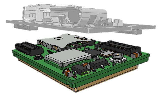
OriginGPS’ latest release is the multi-constellation ORG1518-MK06 module. It combines low power modes for extended battery life, 8MB built-in Flash memory, AGPS support for extended ephemeris improving position calculation, and UART+I2C or UART+SPI interfaces.
Selectable add-on sensor boards click on the OriginIoT cellular IoT system, offering backward compatibility with 2G, 3G, CAT1 and CAT M. (Image: OriginGPS)
An ultra-sensitive integrated patch antenna easily switches over to an external antenna via an integrated RF switch.
The ORG1518-MK06 is suitable for solutions requiring multiple antenna options, such as automotive aftermarket and agriculture applications.
Addressing the global IoT market with fast data transmission, the OriginIoT NB-IoT/CAT M with 2G fallback will be suited to devices that are battery-powered and transmit data only occasionally, such as parking and agriculture applications, resulting in a very long sensor battery life, typically 10+ years. The new model will be released later this year.
“The new products are based on OriginGPS patented technologies and retain the miniature footprint for which the company has become synonymous,” said Robert van Tilburg, vice president, Global Sales and Business Development, OriginGPS. “We are excited to offer our customers additional features and options to choose from, enabling them to reduce overall solution costs. 2019 is going to be an exciting year with technology advancements facilitating our product offering with more personalized IoT and GNSS products.”
OriginGPS partner Gemalto will also be presenting OriginIoT demos at Hall 3, Booth 3-438. Gemalto’s Cinterion LTE-M module is integrated in the OriginIoT systems to provide 2G, 3G, Cat1, Cat-M and NB-IoT cellular communication.
Airbus Defence and Space has launched The OneAtlas Platform, a collaborative environment to access premium imagery, perform large-scale image processing, extract insights and benefit from Airbus assets for solution development.
OneAtlas is offering a 30-day free trial, giving customers streaming access to imagery, sample change detection reports, and global imagery and data layers, including the basemap and the WorldDEM.
Besides access to a comprehensive archive with premium imagery, users can try services such as:
Ocean Finder for the maritime industry
Verde for precision agriculture
Starling for forest management
Earth Monitor for tracking changes over an area of interest
The developer portal provides more information through API documentation and discusses how to benefit from the imagery either in streaming or download format.
The Ocean Finder provides a satellite-based maritime ship detection service. (Photo: OneAtlas)
DIRT, the AMW Machine Blade Control Solution. (Photo: AMW)
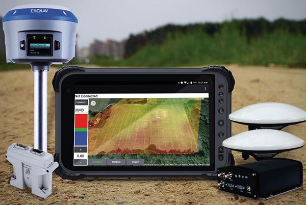
AMW Machine Control Solutions, a subsidiary of CHC Navigation, has introduced four new solutions for the survey, construction and agriculture markets, all of which run on Android and CHC Navigation GNSS tablet hardware.
GRADE I and II Products. GRADE I runs on a CHC Navigation industrial tablet and utilizes an internal meter-accurate GNSS receiver for field workers and supervisors to view layered maps including design files, topo or Google Maps for locating elevations and topographical features.
GRADE II adds centimeter elevation and positioning accuracy with an external CHC Navigation RTK-capable GNSS receiver that wirelessly communicates with the tablet.
GRADE II collects topographic data on the jobsite by walking or driving the area, eliminating surveyor stakes and providing accurate data for earth-moving operations. The density of elevation points can be adjusted. The GRADE II “Smart Base” allows a user to establish RTK control points.
DIRT I and II Products.
DIRT combines GRADE II mapping functionality with automatic blade control for skid steer, scraper, grader or dozer applications for rough and fine land-shaping activities on large or compact equipment. DIRT is available as DIRT I or DIRT II versions depending on the type of blade control needed. Utilizing additional sensors, DIRT II adds the ability to manage cross slopes.
DIRT includes an RTK GNSS, inclinometers, tablet computer, CANBUS controller and DIRT software running on a CHC Navigation tablet. The tablet wirelessly connects to the RTK receiver and other sensors, making the system easily portable so it can be reinstalled on other equipment.
For agriculture applications, AMW Solutions’ proprietary algorithm within the DIRT solution results in accurately graded surfaces within the limits of the equipment.
Industry experts share how GNSS can be used for precision agriculture.
Vazquez
EUROPEAN SATELLITE SERVICES PROVIDER (ESSP)
Juan Vazquez Team Leader, EDAS Service Provision
Pass-to-pass accuracy is the key performance indicator to assess the precision of guidance systems, characterizing the short-term dynamic performance determined from off-track errors along the straight segment passes (error with respect to the desired path in the direction perpendicular to the tractor trajectory).
The results of the tests reported in this article, jointly performed by Topcon Agriculture and ESSP, confirm that EDAS DGPS corrections can support a wide range of precision agriculture applications and represent a real alternative for cereal farms, when located in the vicinity (at least up to 260 km away) of an EGNOS reference station, complementing the benefits that the EGNOS signal-in-space is already providing to a large number of agriculture users in Europe.
EFFIGIS GEO-SOLUTIONS
Nicos Keable-Vézina Director of Precision Agriculture
Thanks to artificial intelligence, variable-rate application of nitrogen has made great strides in recent years. Science has demonstrated that effective nitrogen management requires an array of technologies, including massive databases. Data is geospatial (positioning signal and satellite imagery enabling the identification of changes in nitrogen requirements), agronomic (mainly soil texture and seasonal weather), and economic (grain and nitrogen price).
To automate extraction and analysis of such data, combining very low-cost positioning technologies, satellite imagery and artificial intelligence is paramount. A democratized access to technology has led to the development of scientifically proven nitrogen prescribing platforms, among them FieldApex, that calculate the most profitable nitrogen rates and generate prescriptions in seconds without soil sampling. Further technological and platform integrations are likely to bolster such innovation.
Rioja
TOPCON AGRICULTURE
Julian Rioja Channel Development and Business Intelligence Manager
All tests were performed using Topcon receivers, vehicles and auto-steering systems. Two different Topcon guidance systems on board tractors ran simultaneously to assess the EDAS DGPS positioning performance with respect to the reference provided by a real-time kinematic (RTK) system. Hence, two independent positioning outputs were continuously available (the receivers were placed along the same longitudinal axis on the roof of the tractor):
RTK position: provided by the AGI-4 receiver fed by Topcon’s Hiper V RTK base.
DGPS position: provided by the AGI-4 receiver fed by the EDAS Ntrip service.
On board the tractor, two Topcon X35 consoles were each connected to one of the receivers. A Topcon AES-25 electric steering system was installed on the tractor so that the selected navigation input (RTK or EDAS DGPS) could be used to automatically guide the tractor along the defined reference pattern.
McClure
HEMISPHERE GNSS
John McClure Engineering Manager, Precision Agriculture
Precision agriculture is expanding the use of ISOBUS for CAN communication between a common terminal and implements, to reduce clutter in the cab. These virtual terminals now act as display and user entry for multiple applications including GNSS receivers and factory or after-market steering systems.
INS-aided GNSS solutions, typically using RTK or satellite-based correctors such as Atlas, provide time/position data for rate and section control and auto-steering. CAN-based NMEA 2000 is the commonly used receiver protocol for position data, replacing serial NMEA 0183.
All major tractor, agricultural equipment, and GNSS manufacturers attend regular “Plugfest” meetings, organized by the Agriculture Industry Electronics Foundation, to test interoperability of products and set common standards.
Smart CAN dongles are being developed to read sensors and control systems, supplying positioned data via telematics as the Big Data for real-time and post analysis.
Agriculture equipment maker Case IH is enhancing the robustness of its RTK+ correction signal network by adding the European Galileo system to the compatible satellites with which it works.
The move will increase levels of signal reception and reliability for farmers using Case IH RTK+-guided autosteering and related technologies.
Real-time kinematic (RTK) systems typically depend on signals from the American GPS or Russian GLONASS satellite networks, both designed primarily for non-civilian use. To give European Case IH users a reliable alternative when using RTK+-guided steering systems with their sub-1.5-centimeter repeatable accuracy, Case IH AFS RTK+ now also uses Galileo.
The addition of Galileo to the global GNSS constellation helps minimize the risk of signal failure, a key driver for the integration of its signals into the Case IH AFS RTK+ signal system. European satellite network independence is a principal objective, but Case IH AFS RTK+ is also designed to be compatible with existing and planned GNSS satellites and interoperable with GPS and GLONASS.
Galileo benefits farmers by minimizing downtime from waiting for lost signals to be regained, and ensures consistent efficient use of seed, fertilizer and crop protection products through parallel passes with minimal overlap, thereby maximizing crop potential.
“The use of GNSS technology is opening up new productivity levels and opportunities in European agriculture, providing farmers with an unprecedented level of knowledge about their crops, livestock and operations while making the sector more efficient, economically competitive and environmentally sustainable,” said Maxime Rocaboy, product marketing manager, AFS technology, at Case IH.
“Enhanced RTK+ accuracy through incorporation of signals from the Galileo satellite system is a core way in which we can help Case IH tractor and combine users be innovative and competitive as they seek to help develop a sustainable agriculture to feed an ever-increasing world population in an environmentally responsible way,” Rocaboy said.
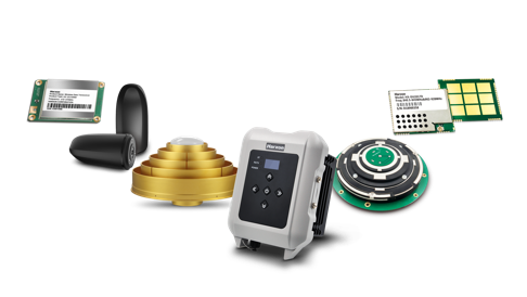
Harxon is showcasing high-precision positioning GNSS antennas and its latest wireless data transmission technologies for surveying applications at Intergeo, Oct. 16-18, in Frankfurt, Germany.
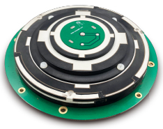
Image: Harxon
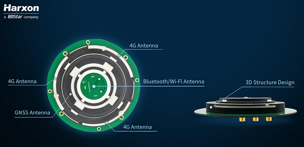
X-Survey is an 4-in-1 OEM antenna for both navigation and communication in the real-time kinematic (RTK) surveying applications. It provides standard Wi-Fi, Bluetooth, 4G, and multiple-constellation signal reception for GNSS positioning.
Its 3D design ensures a higher phase center stability and longer communication distance at a 360-degree direction, while lowering the impact of electromagnetic interference (EMI), hence increasing the overall machine efficiency and simplifying the RTK integration, the company said.
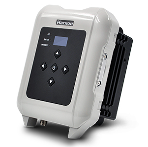
Photo: Harxon
The smart eRadio is a long-range and highly efficient radio modem designed to support RTK applications in surveying and precision agriculture. It can automatically identify RTK serial baud rate and provide a plug-and-play form for easy connection between eRadio and RTK.
According to Harxon, the eRadio’s diagnostic reporting software can configure data and update radio status, allowing users to effectively deal with potential issues. In addition, it is equipped with the unique ETALK communication protocol that increases the communication distance by 20 percent.
Other Harxon GNSS products showcased at Intergeo are for UAVs and precision agriculture, as well as surveying.
The D-Helix antenna HX-CHX600A is featured with its patented D-QHA technology.
Both 3D structured and mini-designed choke-ring antennas HX-CGX601A and HX-CGX611A can be used for base-station communication.
The multi-constellation survey antenna GPS 1000, frequency hopping modem HX-DU2017D and external radio modem HX-DU8608D are also popular products for high-precision performance.
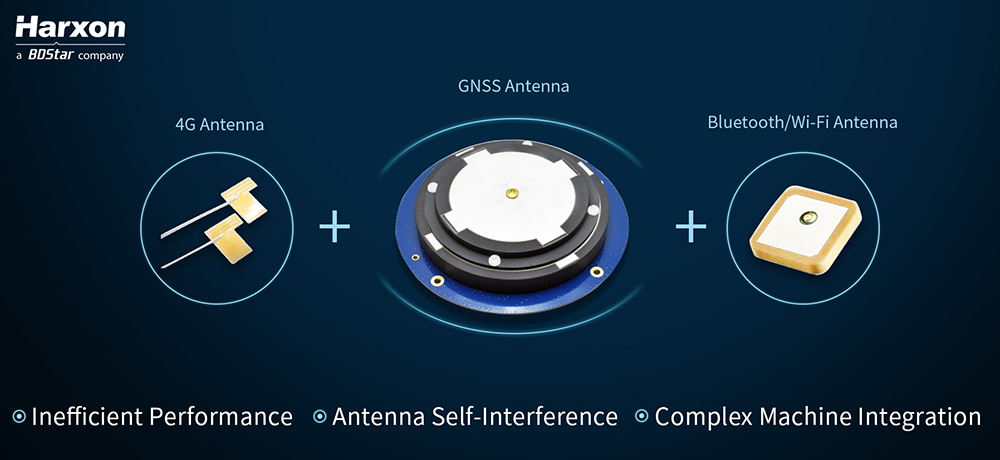
Real-time kinematic (RTK) integration usually uses separate antennas, which can lead to reduced efficiency because of electro-magnetic interference (EMI).
Image: HarxonImage: Harxon
Also, conventional antenna installation can result in unstable machine performance because of the problems of system compatibility between different antennas.
Harxon has overcome those difficulties with its integrated X-Survey antenna, a 4-in-1 OEM antenna for both navigation and communication in surveying applications.
It provides standard Wi-Fi, Bluetooth and 4G, plus multiple constellation signal reception for GNSS positioning.
The high-gain and wide-beamwidth GNSS antenna features a multi-point feeding technology, ensuring a high phase-center stability and positioning accuracy, the company said. Moreover, the array-arranged 4G antennas enables more stable signals and longer communication distance at 360-degree direction, increasing the overall machine efficiency over conventional antennas.
The X-Survey antenna provides high isolation among each antenna to prevent self-interference, improving RTK system compatibility. RF coaxial connectors are designed for plug-and-use, keeping high efficiency and lowering the impact of EMI.
The antenna low-noise amplifier features excellent out-of-band rejection performance, which can also suppress the EMI, providing reliable GNSS signals.
The unique structure design simplifies RTK integration, and minimizes the overall machine dimension. Harxon aims to bring system integrators high-efficiency performance of navigation and communication in surveying and precision agriculture applications.
4G bands can be customized according to different countries and regions, the company added.
NovAtel has introduced its SMART7 family of SMART antennas for demanding applications like precision agriculture and machine control.
The SMART7 family features NovAtel’s GNSS + inertial navigation system (INS) SPAN technology; future-ready GNSS; Wi-Fi and internet protocol connectivity; superior tracking performance; and TerraStar-C PRO corrections.
It is ready to increase GNSS availability, accuracy and reliability for major precision-agriculture equipment manufacturers, the company said.
“Manufacturers that serve these demanding industries can now take advantage of the best in precise positioning technology, with added next-generation features including wireless connectivity, SPAN GNSS+INS integration and superior tracking performance, in an even more robust format,” said Gordon Ryley, Precision Agriculture Segment manager at NovAtel. “With this combination of technologies, guidance systems can continue to steer during satellite signal outages and under challenging conditions.”
The SMART7-S includes NovAtel’s tightly coupled SPAN technology, an advanced GNSS+INS integration technology NovAtel said. SPAN provides accurate attitude information that can simplify the development of vehicle guidance systems and bridge GNSS signal outages.
For easier connection to mobile devices and cellular gateways, the SMART7-W includes Wi-Fi and an integrated NTRIP client; the SMART7-I model also incorporates Ethernet. A new advanced ISOBUS-compatible CAN interface also supports NovAtel logs, commands and firmware upgrades.
All models in the SMART7 family provide exceptional positioning availability using signals from all constellations and frequencies to deliver assured positioning anywhere.
Each model includes a VEXXIS antenna, and supports TerraStar-C PRO, the newest offering from TerraStar correction services, which delivers 2.5 centimeters and convergence times of less than 18 minutes in most regions.
As precision guidance, autonomous operations, high-definition geocoded images and high-volume data processing all improve, drone use will continue to increase. OEM receiver manufacturers, sensor suppliers and data-handling companies play key roles in development, and stand to profit thereby.
In particular, use of drones is growing in land management, construction, mining, and farming. An open-pit mine operation can be supported through detailed drone inspection producing high-resolution images. Processed images and data enable keeping tabs on inventory, site changes over time, identifying best areas for further extraction, and monitoring and managing vehicle movement. These tasks required huge amounts of time in the past. Drone overflight and processing tools condense all the effort as well as producing enhanced results to enable faster and clearer decision-making.
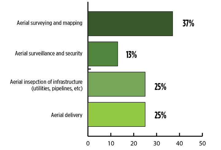
What is the biggest challenge for the UAV industry? (Source: GPS World 2018 State of the Industry survey)
Defense. Surveillance and reconnaissance are probably the biggest military drone applications. Carrying payloads that include color video cameras and infrared night vision cameras, more than 19,000 drones are now in the arsenal of the U.S. Army, Air Force, Marines and Special Ops, and more have gone to other nations’ militaries.
Flying at relatively low altitude, with somewhat limited range and powered by a single quiet electric motor, these drones have become essential in gathering forward-situation intelligence.
Other UAV craft provide higher altitude, longer-duration surveillance and reconnaissance over wider range: up to 20 hours, up to 15,000 feet, more than 60 miles afield. Civilian versions of these craft are in development.
Delivery. Respondents to our survey thought delivery will be a breakthrough application for drones. Amazon has several trials running globably. National civil aviation authorities need to move forward with plans to integrate drones into civilian airspace for this initiative to graduate to full-scale operations and achieve their objective of 30 minutes from order to delivery.
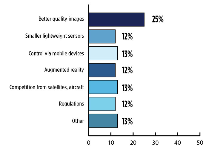
What is the killer app for drones? What professional UAV market sector will most powerfully drive adoption and influence new regulations for unmanned aerial vehicles? (Source: GPS World 2018 State of the Industry survey)
Precision Agriculture. One of the most significant applications which seems to be missing from survey responses is agriculture. Both quadcopters and hybrid fixed-wing/copter drones are in widespread use to capture image data overflying crops, and then process the data and build crop analytics. Graphic results point to how crops can be managed to increase yield.
Making this work is a combination of sensor payloads gathering visual, video, lidar, thermal and hyperspectral data; the secret sauce lies in how the data is processed and presented to farmers. Emphasis is placed on exactly how “green” crops appear when inspected by the various sensors. A number of companies offer services for farmers to optimize crop management.
All these areas are show significant drone growth. Let’s not forget facility, transmission line and pipeline inspection — tasks where drones excel at increasing efficiency and decreasing costs.
For more results from the 2018 State of the GNSS Industry, see this page.
Tony Murfin is a GNSS aerospace consultant with several decades experience at leading companies in the GPS/aviation and OEM sectors.
Hemisphere GNSS has closed its definitive agreement to purchase all of the assets of the Outback Guidance business from AgJunction Inc., along with a new technology licensing agreement.
The acquisition aligns well with Hemisphere’s continued push into the global agriculture market, the company said. In addition to the included IP (intellectual property) licenses for business into the dealer channel, a second license was finalized to allow agriculture steering solutions sales into OEM (original equipment manufacturer), VAR (value-added reseller), and all other segments of the agriculture supply chain.
Hemisphere has assumed ownership of the Outback assets, including a global sales channel, infrastructure and trademarks. Additionally, licenses to IP and related technology have been executed. Also included are two product development, sales and support facilities, including personnel, located in Hiawatha, Kansas, and Winnipeg, Manitoba, Canada.
“Outback’s highly knowledgeable personnel and dealer network will provide us with a key piece of the agriculture supply chain that perfectly complements Hemisphere’s current global agriculture strategy,” said Farlin Halsey, president and chief executive officer of Hemisphere GNSS.
Jeffrey Farrar will lead the Outback business as general manager. Before joining Hemisphere, Farrar was vice president of sales for AgJunction and served in a capacity of director and senior management-level positions for both sales and marketing for AgJunction and Hemisphere GPS. “Jeffrey’s previous leadership and history with the Outback business makes him the ideal person to direct the future growth of this business,” Halsey said.
“Outback has always been a household name in the agriculture space associated with simplicity, performance, and value, and we intend to keep it that way,” Farrar said. “I look forward to ensuring that the Outback business thrives and that the solution and technology offerings are maintained and supported, as we look to refresh and update product lineups. We are committed to helping and supporting our dealer network, farmers, and growers alike to ensure they continue feeding the world.”
The addition of Outback represents Hemisphere’s continued effort to make significant investments to expand its presence in the global agricultural market. Hemisphere has seen successful revenues and wide-reaching positive feedback in recent years with its OEM-focused agriculture products. Hemisphere seeks to further integrate its high-precision GNSS positioning technology via systems and services offered by the Outback dealer network.
The Outback channels of communication including customer support, sales and website, will remain as they currently operate. The Outback dealer network will not see any interruption during this transition period.
The transaction is expected to close in the third quarter, contingent on normal regulatory approvals.
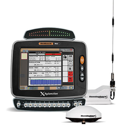
The Outback MAX terminal with ISOBUS. (Photo: Outback Guidance)
The acquisition aligns with Hemisphere’s continued push into the global agriculture market, Hemisphere GNSS said. In addition to the included IP licenses for business into the dealer channel, a second license was signed to allow agriculture steering solutions sales into OEM (original equipment manufacturer), VAR (value-added reseller) and all other segments of the agriculture supply chain.
As a result of these agreements, Hemisphere will assume ownership of the Outback Guidance assets, including channel, infrastructure and trademarks. Additionally, licenses to intellectual property and related technology have been executed.
Also included are two product development, sales, and support facilities, including personnel located in Hiawatha, Kansas, United States, and Winnipeg, Manitoba, Canada.
“The decision to acquire the Outback Guidance business will significantly accelerate Hemisphere’s expansion into the global agriculture market and allow stronger integration between Hemisphere’s core competency GNSS and Outback’s highly refined steering solutions,” said Farlin Halsey, president and chief executive officer of Hemisphere GNSS.
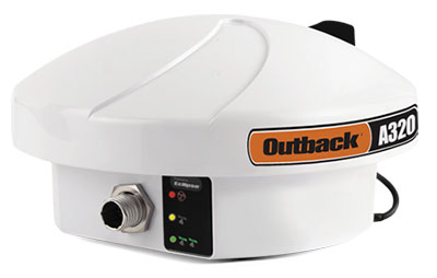
The Outback A320 smart antenna. (Photo: Outback Guidance)
“We are very pleased to be bringing on board additional seasoned personnel with strong agriculture domain experience, a strong product line with deeply embedded agricultural technology and a well-accepted, reputable brand in Outback,” Halsey said. “We will also be bringing back together many years of history and legacy between the two organizations.”
The addition of Outback Guidance represents Hemisphere’s continued effort to make significant investments to expand its presence in the global agricultural market. Hemisphere has seen successful revenues and wide-reaching positive feedback in recent years with its OEM focused agriculture products. Hemisphere seeks to further integrate its high-precision GNSS positioning technology via systems and services offered by the Outback Guidance dealer network, the company said.
The Outback Guidance channels of communication including customer support, sales, and website will remain as they currently operate. The Outback Guidance dealer network will not see any interruption during this transition period.
CHC Navigation has acquired the business assets and personnel of AMW Machine Control Inc. The business will now be conducted by AMW Machine Control Solutions Inc. as a subsidiary of CHC Navigation.
AMW Machine Control Solutions has more than 30 years of advanced machine guidance, machine control and GNSS experience. Its topographic and machine-control software solutions include grade, dirt, ditch, pipe, landfill and road. AMW Machine Control Solutions offers cost-effective solutions designed for equipment operators, the company said.
The offerings of AMW Machine Control Solutions will be based on turnkey, wireless CHC Navigation Android industrial tablets and CHC Navigation’s RTK GNSS receivers.
AMW Machine Control Solutions has appointed Phil Gabriel as president. Gabriel has more than 25 years of experience in the positioning industry. He previously served as president of Hemisphere GNSS Inc. and is currently serving as the general manager for CHC Navigation North America.
With these changes, CHC Navigation said it is poised to significantly grow its global market share in the agriculture civil engineering and construction industry, with products catering to small, medium and large enterprise farming and construction equipment users.
“Our customers really like CHC Navigation’s positioning products and their new Android tablets,” said Mark Williams, founder of AMW and now director of product management. “We have redeveloped our popular applications from the ground up to run Android while being more intuitive and wireless, wherever possible. With standardized hardware, AMW Machine Control Solutions will be able to better support our existing customers and to attract new ones.”
“AMW has been innovating in-machine control for many years. We are pleased to combine forces to offer the market incredible value and simple to use products,” Gabriel said.