The Notilo Plus team with the iBubble. (Photo: Notilo Plus)
Notilo Plus has launched iBubble, a fully wireless, autonomous and intelligent underwater drone. iBubble can accompany divers for up to an hour and down to 197 feet depth, acting as their personal cameraman and enabling superior underwater imaging.
Founded in 2016, Notilo Plus is a Marseille, France-based start-up created to develop intelligent underwater exploration technologies.
The remotely operated vehicle (ROV) was designed using Notilo Plus’ patented underwater localization technology, enabling subaquatic adventures without tethers. It comes with an advanced artificial intelligence system, offering total autonomy and self-learning capabilities.
The localization technology is mainly based on acoustic signal transmission and image recognition (video tracking). By combining these technologies, iBubble is able to locate precisely its target underwater and thus shoot perfectly stable footage.
iBubble is equipped with an obstacle avoidance system, which allows it to smoothly follow a diver, while obtaining images of unparalleled quality for personal or commercial use, the company said. It features real-time image recognition, a stabilization system and direct surface control, bringing outstanding performance to underwater imaging.
The iBubble ROV is an environmentally conscious device — it does not disturb the fragile marine ecosystem thanks to its minimal noise emission levels and its obstacle-avoidance capability.
iBubble can be used for sports and entertainment filming, diving instruction, wildlife protection, search-and-rescue operations, naval or underwater infrastructure maintenance, and subsea patrolling.
“We are excited to introduce to the world the first fully wireless, autonomous underwater drone,” said Nicolas Gambini, CEO of Notilo Plus. “With the countless cutting-edge technologies brought by the iBubble, coupled with its ability to bring exceptional pictures and video footage, this is a remarkable and versatile device for any diving activity.”
The device is now available for order globally. The first batches of iBubble drones will be delivered to the customers, including the Indiegogo crowdfunding campaign supporters, from mid-November 2018.
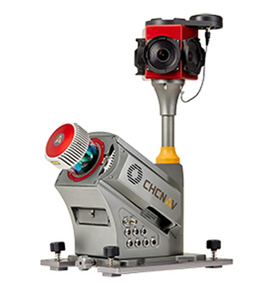
CHC Navigation has launched the Alpha3D Mobile Mapping solution, which provides a unique combination of sensor technologies and the company’s core GNSS expertise.
The Alpha3D is a high-performance, vehicle-independent mobile mapping solution that can capture mass data in continuously changing world environments, enabling geospatial professionals to get work done quickly and more accurately to increase their return on investment.
The Alpha3D can be mounted on a variety of platforms, including different type of vehicles, trains, railway trolleys and boats. It rapidly and efficiently collects high density, accurate point clouds and powerful image data. It also adds extra information from additional sensors, such as a high-resolution camera, thermal camera, echo sounder or extra profiler.
The Alpha3D combines high-performance hardware — including a long range, ultra-high speed, precise laser scanner, high-resolution HDR panoramic camera in combination with an advanced GNSS receiver and high-precision inertial measurement unit (IMU) — in one instrument in a light weight, compact yet rugged design, according to George Zhao, CEO of CHC Navigation.
“All theses features keep Alpha3D as one of most innovative system in market today,” Zhao said.
“With Alpha3D, users can collect more data faster and reduce time in the field more than 40% compared to traditional surveying instruments,” said Andrei Gobb, product manager of Mobile Mapping Solutions. “By combination of point clouds and high-resolution images, as well as information from additional sensors, there is no need to return to site for remeasurement.”
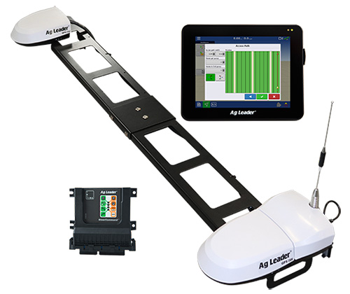
Ag Leader has unveiled new guidance and steering solutions for precision agriculture, including a dual-antenna automated steering system and the latest in GNSS technology.
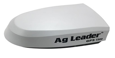
The GPS 7500 GNSS smart antenna. (Photo: Ag Leader)
The GPS 7500 is a field-ready, multi-frequency GNSS smart antenna providing the latest technology including access to multiple GNSS signals for up to sub-inch accuracy and increased performance in variable terrain.
When combined with NovAtel’s TerraStar-C PRO differential correction service, GPS 7500 receives multi-constellation support for better satellite availability.
A full range of performance accuracies are available from GLIDE to RTK, offering a variety of solutions for customers. Combined with SteerCommand, the GPS 7500 offers sub-inch real-time kinematic (RTK) accuracy using the Relay 400, Relay 900 or InCommand NTRIP Client.
The receivers with InCommand software. (Photo: Ag Leader)
Wi-Fi capability within GPS 7500 allows for base-station configuration from a smartphone or tablet.When uptime is valued over absolute accuracy, integrated StableLoc technology utilizes available correction signals to provide a seamless transition between correction sources — without position jumps — and maximize signal uptime.
“SteerCommand with DualTrac brings a dual-antenna offering to the market that provides RTK accuracy and meets the needs of many farmers requiring high-accuracy automated steering at low speeds,” said Bill Cran, Ag Leader product specialist. “New GNSS technology in the GPS 7500 was leveraged to make this possible and also adds new satellite and correction offerings including TerraStar-C PRO.”
The GPS 7500 supports the new TerraStar-C PRO service, available in 3-month and 12-month subscriptions. TerraStar-C PRO offers multi-constellation/multi-frequency positioning with greater accuracy, availability and reliability than before. Its convergence is 60-percent faster and accuracy 40-percent better than TerraStar-C to overcome challenging signal conditions such as multipath, shading, interference and scintillation.
SteerCommand with DualTrac. Combining the GPS 7500 receivers with SteerCommand and InCommand displays offers automated steering control with sub-inch accuracy at ultra-low speed (as low as 0.05 mph). SteerCommand with DualTrac is designed for operations requiring precise steering such as planting or harvesting bedded crops, installing drip tape or planting and harvesting specialty crops. It provides a stable heading, even when the vehicle is not moving, as well as rapid line acquisition in forward or reverse.
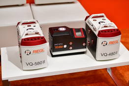
Riegl now offers several new sensors and systems for airborne data gathering at various elevations.
At Intergeo 2018, the company unveiled sensors designed for low-flight altitudes, such as with UAVs. Riegl also introduced sensors designed for medium-flight altitudes used in large UAS/UAV/RPAS with higher payload capacity or in manned helicopters, and scanners and systems for data acquisition at high flight altitudes using manned fixed-wing aircraft.
The Riegl VQ-480II and VQ-580 II on display at Intergeo 2018. (Photo: Riegl)
Medium altitude. The Riegl VQ-480 II (Mark 2) and VQ-580 II (Mark 2) are designed for airborne applications at mid-altitudes for use on both manned and unmanned aircraft. Based on the capabilities of their predecessors VQ-480 and VQ-580, their new, sophisticated designs lead the quality of the systems to a new standard of performance and user-friendliness.
Both offer a measurement rate of up to 1,250,000 measurement/second and a wide field of view of 75 degrees, suitable for corridor mapping, city modeling and applications in agriculture and forestry.
With approximately 10 kg of weight, they are ready for integration into helicopters as well as unmanned UAVs with a higher payload capacity, and are compatible with stabilized platforms and even small hatches.
The VQ-480 II and VQ-580 II are prepared for smooth GNSS/IMU integration, offer interfaces for up to five optional cameras, and are equipped with a removable storage card and an integrated SSD for data storage.
While the VQ-480 II works at a laser wavelength of 1550 nm, the VQ-580 II works at 1064 nm wavelength suited to measure on ice and snow.
Laser scanning. Riegl’s VUX series, focusing on unmanned laser scanning, has also been expanded. With the Riegl VUX-240, a new airborne lidar sensor with less than 4 kg weight and a sophisticated design offering 75-degree field of view is now ready to be integrated on both small manned and larger unmanned aircraft.
The high measurement rate of 1,500,000 measurements/second and a high scan speed of up to 400 lines per second are the basis for high scan efficiency, especially in applications like power lines, railway tracks, pipeline inspection or topography in open-cast mining. Interfaces for an optional GNSS/INS system integration and up to four optional cameras are further convincing key features of the new scanner.
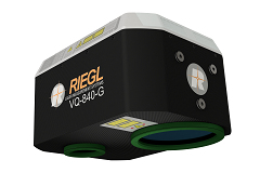
The Riegl VQ-840-G. (Photo: Riegl)
Bathymetry. For the bathymetric segment, the Riegl VQ-840-G has entered the marketplace. Designed for combined topographic and hydrographic surveys for use with large UAVs from lower flight altitudes, the scanner carries out laser range measurements for high-resolution surveying of underwater topography utilizing a green laser beam.
The scanner’s compact, lightweight and robust housing also can include an optional digital camera and an additional, fully integrated infrared laser rangefinder, and is compliant with typical hatches in aircrafts and with stabilized platforms.
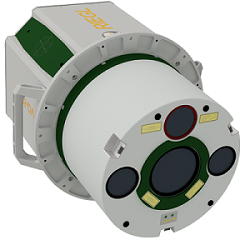
The Riegl VQ-880-GII. (Photo: Riegl)
Airborne laser scanning. The Riegl VQ-880-GII is a further improvement of the VQ-880-G topo-hydrographic airborne laser scanning system, offering online waveform processing and full waveform recording.
The improved setup includes a green laser channel, an integrated infrared laser channel, and an integrated dual camera system for RGB and IR. Typical applications include coastline and shallow water mapping, acquiring base data for flood prevention, and measurements for aggradation zones.
Also available are the VQ-780i airborne laser scanner and the VQ-1560i dual wavelength airborne mapping system.
Telit GE310-GNSS IoT Module fills European demand for GSM/GPRS compact form factors, and is part of Telit’s migration-support program that helps customers leverage 2G’s low cost and broad coverage while preparing for 4G and 5G.
The GE310-GNSS module. (Image: Telit)
Telit has released the GE310-GNSS, an internet of things (IoT) module with GSM/GPRS, multi-constellation satellite positioning and Bluetooth functionality in a 270-millimeter-squared form factor.
The GE310-GNSS enables original equipment manufacturers (OEMs) and system integrators in application areas such as asset management, utilities and telematics, meet strong demand for low-cost, highly compact devices without tradeoffs in performance, reliability and functionality, particularly in regional markets such as Europe, where 2G is forecast to remain in strong growth in number of IoT connections for many years.
The GE310-GNSS features a miniature form factor packaged in an LGA 94-round-pad format. It is designed to meet the robust demand in Europe, Latin America and other regional markets for compact devices such as health and wellness monitors, smart residential and commercial thermostats, commercial fleets and IoT-connected grid equipment for smart utilities.
With support for Europe’s Galileo as well as other satellite positioning constellations, the GE310-GNSS is suitable for IoT applications that require location awareness throughout Europe and the rest of the world. The module’s Bluetooth 4.0 capability makes it easy for OEMs to add connectivity to proximal area network devices, Telit said.
The GE310-GNSS is part of Telit’s future-proofing program, which helps customers leverage 2G’s low cost and gapless European coverage immediately while retaining absolute control of when they switch to a compatible 4G module in the Telit family lineup.
The lineup includes multiple roadmap paths to upgrade to 4G and later to 5G based on the customer business strategies and specific market conditions.
Research firm ABI Research estimated in its “ABI IoT Market Tracker – Worldwide – October 2018” that 2G cellular IoT connections will continue to grow in Europe from 100 million in 2018, reaching a peak of 148 million connected devices in 2022 before slowly dropping to about 89 million in 2026.
“The GE310-GNSS is the newest in our lineup of updated 2G modules for markets like Europe and Latin America which still show a sustained pull for over half a decade,” said Yossi Moscovitz, president products and solutions, Telit. “This svelte module combines proven, reliable 2G connectivity with the latest satellite positioning and Bluetooth technologies, all backed by Telit’s decades-enduring migration-support program. Telit has helped thousands of customers through cellular generational transitions and is now helping 2G customers in Europe, Latin America and other regions develop business-enhancing roadmaps to 4G and 5G.”
For more information about the GE310-GNSS and other Telit IoT solutions, visit booth A.b80 at European Utility Week, Nov. 6-8 in Vienna, Austria.
A roundup of recent products in the GNSS and inertial positioning industry from the November 2018 issue of GPS World magazine.
OEM
Simulator signals
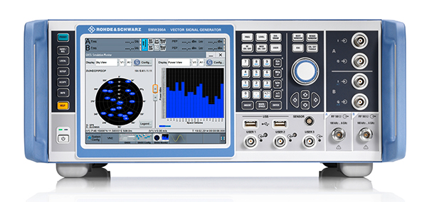
GPS L5 and Galileo E5 added to simulator
Photo: Rohde & Schwarz
Rohde & Schwarz has added GPS L5 and Galileo E5 simulation capabilities to its R&S SMW200A GNSS simulator. The R&S SMW200A GNSS simulator is designed for efficient test and characterization of multi-constellation and multi-frequency GNSS receivers. It now enables generation of complex and highly realistic test scenarios with up to 144 channels in the GNSS frequency bands L1, L2 and L5. In addition to GPS (L1/L2/L5), GLONASS (L1/L2), Galileo (E1/E5) and BeiDou (L1/L2), the R&S SMW200A also supports signal generation for QZSS and SBAS on L1. Channels can be routed to up to four RF outputs, so that even multi-antenna systems can be tested. The R&S SMW200A can generate complex coexistence and interference scenarios with multiple interferers.
The BlueSky GNSS Firewall enables critical infrastructure providers to harden the security of their operations from GPS threats and deliver a more reliable and secure service. The security-hardened system provides protection against GPS threats such as jamming, spoofing and complete outage. It also supports a range of precision timing technologies, including atomic clocks, to enable continuous operation when GPS may be completely denied for extended periods. The TimePictra software management suite provides centralized control and visibility of GPS reception across regional, national and global geographic areas. It can incorporate an optional internal miniature atomic clock.
For reference deployments, CORS networks and monitoring
The VeraChoke GNSS antenna. (Photo: Tallysman)
The VeraChoke is a high-accuracy choke ring antenna with a choice in form factor for reference and monitoring applications. The VC6100, the first model variant of the VeraChoke, shares a common high-efficiency element design with its counterpart VeraPhase. With the choke-style form-factor, however, the rings have been optimized for all GNSS signals and are slightly pyramidal in shape to improve reception of low-elevation satellites. The VC6100 offers a tight phase center variation (PCV) of no more than ±1 mm for every frequency. It is capable of receiving all GNSS signals, and achieves a very low axial ratio. The antenna also supports large and small SCIGN radomes.
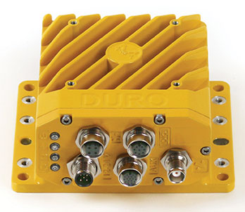
Duro Inertial is a ruggedized version of Swift Navigation’s Piksi Multi dual-frequency real-time kinematic (RTK) GNSS receiver combined with Carnegie Robotics’ SmoothPose sensor fusion algorithm, which fuses GNSS and inertial measurements into a combined solution. The blending of GNSS and inertial measurements provides a dead-reckoning capability that allows Duro Inertial to provide a highly accurate, continuous position solution during brief GNSS outages and to deliver a robust precision navigation solution in harsh GNSS environments.
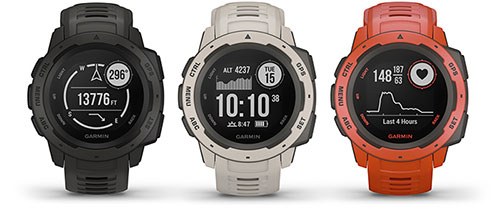
The durable Instinct has GNSS; three-axis compass; barometric altimeter; and wrist-based heart-rate sensor. The watch includes a built-in sports apps, smart connectivity and wellness data. It is built to endure challenging environments, and is constructed to military standards for thermal, shock and water resistance. The multi-GNSS feature helps users track their location in challenging environments, while the Garmin Explore app helps plan and track a trip.
The Navsight Land & Air Solution provides high-performance inertial navigation to make surveyors’ mobile data collection easier, whether for mobile mapping, GIS or road inspection. The solution consists of an inertial measurement unit (IMU), available at two different performance levels, connected to Navsight, a rugged processing unit embedding fusion intelligence and a GNSS receiver. It also has connections for external equipment such as lidar, cameras or computer. SBG’s fusion algorithms allow the company to get the best performance from inertial, odometer and GNSS technologies; exclude false GNSS fixes; and improve the trajectory in complicated areas such as urban canyons, forests and tunnels. The solution supports all GNSS constellations, and real-time kinematic (RTK) and precise point positioning services such as Omnistar and TerraStar.
iSTAR Pulsar is designed to capture 360-degree data while mounted on a vehicle, drone or on foot. An upcoming feature in cloud-based processing software VR.WORLD uses artificial intelligence and image recognition to analyze the images captured by iSTAR Pulsar so that objects like cars, trucks, traffic lights, road signs, pedestrians and cyclists can be automatically identified in images. Handheld 3D mobile mapping company GeoSLAM and mobile mapping software company Orbit GT have introduced integration with iSTAR Pulsar.
The SMART7 family features NovAtel’s GNSS + inertial navigation system (INS) SPAN technology; future-ready GNSS; Wi-Fi and internet protocol connectivity; superior tracking performance; and TerraStar-C PRO corrections. It is designed to increase GNSS availability, accuracy and reliability for major precision-agriculture equipment manufacturers. The SMART7-S includes SPAN technology, the SMART7-W includes Wi-Fi and an integrated NTRIP client, and the SMART7-I model also incorporates Ethernet. All SMART7 models provide exceptional positioning availability using signals from all constellations and frequencies to deliver assured positioning anywhere.
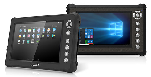
The DT301X rugged military-grade tablet is purpose-built to enhance the precision of 3D surveying, crime and crash scene reconstruction, and bridge and other construction inspections. An option is a dual-frequency GNSS module for real-time mapping and positioning. The tablet integrates the Intel RealSense depth camera, which provides real-time 3D imaging providing accurate measurements for CAD, engineering, design, utility management and crime-scene forensics. A high brightness 10.1-inch touchscreen offers flexible viewing in a wide range of lighting, and an Intel eighth-generation Core i5 or i7 processor offers high-performance while still being energy efficient. With high-capacity 60- or 90-watt hot-swappable batteries, the DT301X keeps working continuously, complemented with a variety of battery chargers so fully charged batteries are always available.
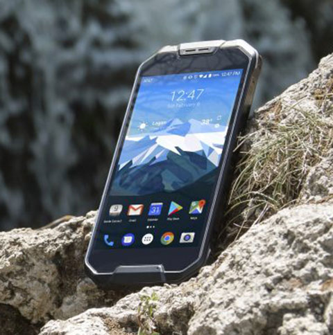
The Cedar CP3 rugged smartphone is capable of data collection and communication. It has a high-visibility 5.5-inch AMOLED display; 14- to 16-hour battery life operating at full brightness and running GPS; 16-megapixel user-facing camera and dual 12-megapixel rear camera; and 6 gigabytes of RAM with 64 gigabytes of internal storage.
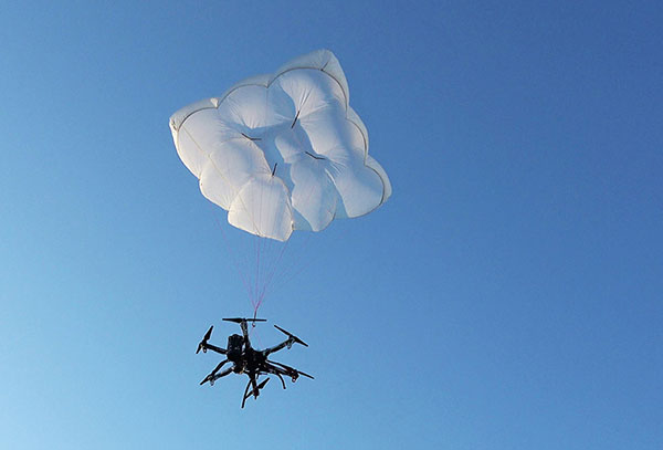
Parachute rescue system DRS-5 is designed for multicopters up to 8 kg; the DRS-10 for multicopters weighing 5–20 kg. The system consists of a carbon cage in which the parachute is stored as well as associated electronics. The electronics, including the sensors, monitor the flight status of a drone independent of the flight controller. A sophisticated algorithm merges this sensor data, enabling automatic crash detection and parachute ejection. All flight data and movements are recorded in a black box.
PrecisionPass assesses UAV data collected in the field. The toolkit lets pilots quickly determine if a data-collection job meets the required criteria or if it needs to be collected again. PrecisionPass assesses coverage, assesses image resolution and quality, reviews required metadata, speeds upload and processing times, and packages data for processing. The immediate feedback reduces the risk of failures during the analysis stage, all but eliminating the need to re-fly a mission, so customer needs are met in a timely and cost-efficient manner.
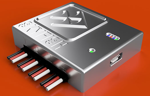
The Skyfish computing platform fully automates crucial infrastructure inspection and measurement tasks. It supports DJI and PixHawk flight controllers and other drone architectures, as well as 3D modeling software from companies such as Bentley Systems. Its easy-to-use interface enables anyone to fly, inspect and model complex infrastructure. The platform also pre-processes the collected infrastructure data and metadata to help create impeccable 3D models.
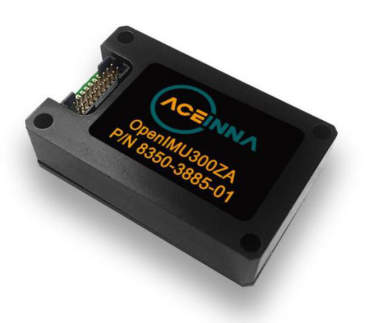
OpenIMU is a professionally supported, open-source GPS/GNSS-aided inertial navigation software stack for low-cost precise navigation applications. Integrating an inertial measurement unit (IMU)-based sensor network improves navigation and self-location capabilities. It is aimed at developing autonomously guided vehicles for industrial applications, autonomous cars, industrial robots and drones. OpenIMU enables advanced localization and navigation algorithm solutions; its extensible software infrastructure provides the code needed for algorithm development. A hardware development kit includes JTAG-pod, precision mount fixture, EVB and an OpenIMU300 module that features Aceinna’s 5 deg/hr, 9-Axis gyro, accelerometer and magnetometer sensor suite with an onboard 180-MHz ARM Coretex floating-point CPU.
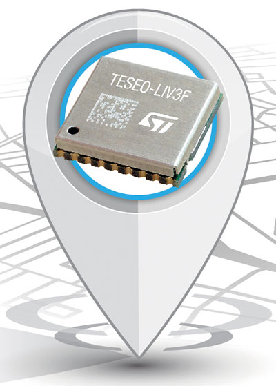
The Teseo-LIV3F module incorporates the Teseo III receiver. It speeds application development and adds up to 16 MB of Flash memory for firmware updating or data logging without a backup battery. Used by automotive and industrial sectors, the Teseo III multi-constellation receiver combines high accuracy with fast response time and low power consumption. The Teseo-LIV3F module enables makers and small engineering teams to leverage the Teseo III advantages in creating new products in the industrial and consumer market segments such as vehicle trackers, drones, anti-theft devices and pet locators, and systems for services such as fleet-management, tolling, vehicle sharing or public transportation.
Audi’s latest e-tron electric car will launch in Europe with a digital rear-view system. Developed by Ficosa, the camera monitoring system is made up of cameras and displays that replace traditional external side mirrors to increase safety and comfort. The vision system is comprised of two cameras, integrated into the sides of the car’s chassis, and two tactile displays inside the doors.
Skycatch has announced an on-premise data processing and GNSS base station, the Skycatch Edge1, manufactured in partnership with DJI and now available worldwide.
Edge1 base station. (Photo: Skycatch)
Tested and optimized for the Skycatch Explore1 and DJI Phantom 4 RTK drones, the self-positioning Edge1 allows commercial drone users the ability to process and receive data without the need for internet or cellular connectivity, the company said.
Field teams can fly their drone, process the data and receive centimeter-level data outputs in 30 minutes or less, directly to a tablet. 2D maps and 3D point clouds are available for viewing and sharing directly from the tablet.
The Edge1 concept began as a companion to the Skycatch Explore 1 drone. Now, a new generation of the Edge1 will support all DJI drones, including the recently released DJI Phantom 4 RTK, and will process any 2D geotagged images.
In addition to a survey-grade GNSS base station, the Edge1 includes built-in WiFi, LTE, reliable sub-5-centimeter accuracy, and delivers high-quality data outputs, the company added. Built around a state-of-the-art compute module, the Edge1 is also capable of running deep learning algorithms to extract more insights from collected data in near real time.
“It’s truly a revolutionary product that we’re excited to make available to the DJI community, and the construction and mining industry at large,” said Christian Sanz, founder & CEO of Skycatch. “With the partnership and support of DJI, the Edge1 will be assembled with precision execution in their world-class manufacturing facility, and will be available faster to the customer.”
“As the commercial drone industry has grown, the amount of data collected by our enterprise users is unprecedented,” said Jan Gasparic, director of strategic partnerships at DJI. “We are glad to work with Skycatch to manufacture the Skycatch Edge1 GNSS base receiver, enabling enterprise customers, especially those in the construction industry, to process data from their DJI drones on-site and in real-time.”
Skycatch is an industrial data collection and analytics company focused on indexing and extracting critical information from the physical world, using a combination of hardware, software and artificial intelligence. Built for enterprise, its turnkey solutions are deployed across global project sites with largest construction, mining and energy companies.
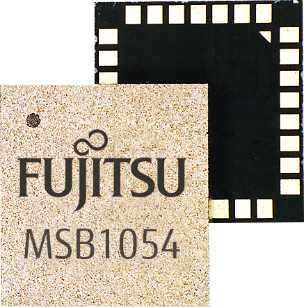
Fujitsu has introduced a low-power multi-GNSS module for consumer devices and asset tracking. (Graphic: Fujitsu)
The MSB1054 multi-receiver module requires no external components and has built-in Flash memory, meeting needs of smartwatches, fitness trackers, logistics and navigation.
Fujitsu Electronics Europe (FEEU) is expanding its ultra-low power portfolio to include a multi-receiver GNSS module: the MSB1054. The ability to receive signals from several satellite systems significantly reduces the time to first fix, providing for faster and more accurate positioning, the company said.
Photo: Fujitsu
Besides the GNSS device itself, the MSB1054 provides a built-in RF-front end (SAW filter, low-noise amplifier) as well as a temperature compensated crystal oscillator (TCXO), so with the exception of an antenna no external component is required.
Furthermore, Fujitsu’s GNSS module is equipped with a built-in Flash memory for quick “hot start” to save the navigation data and further optimize performance.
With its dimensions of 5.8×6.2×1 millimeters and 3.4 mA current in low-power mode (such as for tracking), the MSB1054 is designed for a variety of applications such as smartwatches, fitness trackers and asset tracking, and can navigate indoors or outdoors, the company added.
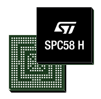
New connected-car automotive microcontroller (MCU) enables secure remote updates and high-speed in-vehicle networking.
Image: STMicroelectronic
STMicroelectronics (ST) has launched a new flagship SPC58 H Line as part of its Chorus series of automotive microcontrollers (MCUs).
The new line can run multiple applications concurrently to allow more flexible and cost-effective vehicle electronics architectures.
The SPC58 H line has three high-performance processor cores, more than 1.2MB RAM and powerful on-chip peripherals, the company said.
As critical vehicle powertrain, body, chassis and infotainment features increasingly become defined by software, securely delivering updates such as fixes and option packs over the air (OTA) enhances cost efficiency and customer convenience, the company said.
With high security and large on-chip code storage, ST’s Chorus automotive microcontroller is a gateway/domain-controller chip capable of handling major OTA updates securely.
Two independent Ethernet ports provide high-speed connectivity between multiple Chorus chips throughout the vehicle and enable responsive in-vehicle diagnostics. Also featuring 16 CAN-FD and 24 LINFlex interfaces, Chorus can act as a gateway for multiple ECUs (electronic control units) and support smart-gateway functionality via 2 Ethernet interfaces also on-chip.
“The way carmakers create, configure, deploy and maintain new vehicles is changing, as software-defined functionality makes advanced features, flexibility and convenience ever more widely accessible,” said Luca Rodeschini, microcontroller business unit director at STMicroelectronics. “Our latest and highest-performing Chorus microcontroller, being OTA-ready and with dual Ethernet ports up to Gigabit speeds, creates a state-of-the-art platform for seamless, safe and secure in-car connectivity and control.”
To protect connected-car functionalities and allow OTA updates to be applied safely, the new Chorus chip contains a Hardware Security Module capable of asymmetric cryptography. Being EVITA Full compliant, it implements industry-leading attack prevention, detection and containment techniques.
Some customers have received samples of the SPC58 Chorus H Line microcontrollers in the next generation of smart gateways and central body modules, and are also evaluating the devices for battery-management units and ADAS safety controllers.
DroneShield has launched DroneNode in response to end-user requirements.
DroneNode is an evolution of the company’s DroneCannon product. It is a portable, compact and inconspicuous counter-drone jamming device that law enforcement can use at large outdoor events without raising public concern.
DroneNode comes in a portable case approximately 50 x 50 centimeters square. It can be set up in seconds and requires very little training to operate, the company said.
It can simultaneously jam 2.4 GHz, 5.8 GHz and GNSS L1 and L2 bands up to one kilometer, causing drones to return to their point of origin or land. DroneNode is also effective against swarm attacks. Emergency broadcasts, cellphone communication and other dedicated channels will not be affected.
According to the company, DroneNode’s covert design makes it a suitable counter-drone solution for public events where protection from drone threats is a priority. Designed within a rugged carry case, DroneNode is easy to transport and is protected from the elements.
DroneNode is powered by a NATO-approved self contained battery with room for a second battery stored in the accessories tray.
“The release of DroneNode continues DroneShield’s leadership in drone security for public events,” said Oleg Vornik, DroneShield’s CEO. “DroneShield’s recent credentials in the area include the 2018 Olympics, the 2018 Commonwealth Games, 2018 ASEAN-Australia Special Summit, the 2017 Hawaii Ironman World Championship, and the 2015 to 2017 Boston Marathons. The company’s products are well positioned to protect large public gatherings globally.”
According to DroneShield, the product is particularly relevant given the recent drone attack on the Venezuelan president and the high-profile mail bomb terrorist attacks in the United States, heightening the awareness of law enforcement globally to potential threats to high-profile political targets.
A Venezuela soldier received head injuries in a the drone attack against the president. (Photo: Released by Xinhua News Agency)
FCC Authorization Pending. DroneNode and DroneCannon have not been authorized as required by the U.S. Federal Communications Commission (FCC). The devices are not, and may not be, offered for sale or lease, or sold or leased, in the United States, other than to the U.S. government and its agencies, until authorization is obtained.
The use of such devices in the United States by other persons or entities, including state or local government agencies, is prohibited by federal law. Laws limiting the availability of such devices of certain types of users may apply in other jurisdictions, and any sales will be conducted only in compliance with the applicable laws.
SmartDrive Systems, a video-based safety and transportation intelligence company, is collaborating with Geotab to provide fleets with integrated solutions that leverage the SmartDrive platform as a single on-board data collection hub.
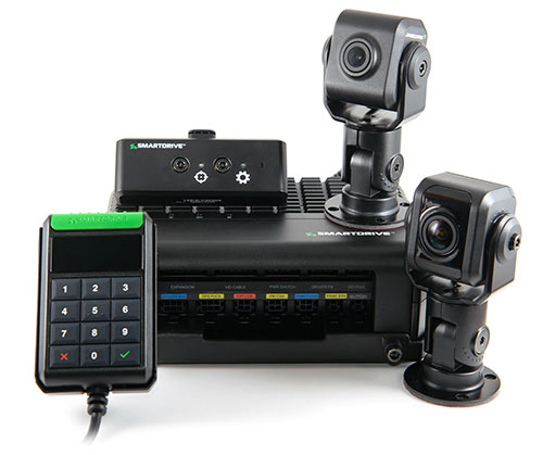
The SmartDrive SR4 video hardware platform. (Photo: SmartDrive Systems)
SmartDrive and Geotab are helping to simplify the on-board technology footprint, providing fleets the freedom to choose solutions that fit their business and their budget, and dramatically lowering the total cost of ownership.
SmartDrive offers a single integrated and aligned understanding of time, location and driver and vehicle performance to third-party applications. Fleets will be able to select solutions without incurring the additional costs associated with managing and maintaining multiple onboard devices.
“The ability to integrate and operate applications from a single data collection platform breaks through significant technology and operational barriers — unlocking efficiency gains for fleets across routes, drivers and risk,” said Steve Mitgang, SmartDrive CEO. “Collaborating with Geotab allows us to make good on the promise of convergence with a company that shares our commitment to providing open, connected and flexible solutions for fleets of every size. We believe this is a transformational shift — and it’s only the beginning of what is possible for our customers.”
With the growth of technology in the cab, fleets are struggling with how to manage the number of devices on the windshield and the connection of those devices in the vehicle.
Video-based safety cameras, electronic logging devices and advanced driver assist system (ADAS) sensors are causing fleets to look for integrated solutions that solve the hardware and data overload problem. Beyond the number of devices on the vehicle, fleets also are contending with the cost to install, maintain and train on each of these technologies. With the migration from 3G cellular networks to 4G, and resulting need to upgrade onboard hardware, fleets have an opportunity to re-think and streamline their technology strategy.
“For too long, traditional telematics systems have saddled fleets like ours with costly hardware that is expensive to maintain and upgrade, and monthly subscription costs that continue to escalate,” said Matt Penland, vice president of safety, Cypress Truck Lines. “There has to be a better way. Fleets should have the same freedom and flexibility to consolidate devices and applications that we all now have on our cell phones. The technology is available to make this possible.”
The SmartDrive platform provides a unified video and telematics data stream that can be leveraged by third parties to power their applications, the companies said. This same data stream powers the SmartDrive video safety program, ADAS and transportation analytics applications.
Through the collaboration, Geotab telematics and compliance offerings take advantage of the SmartDrive single box architecture and unified data stream, eliminating redundancy across hardware, cellular connectivity, GPS modules, connections to the ECU and cabling. It also provides data alignment across the two providers’ applications, unlocking new fleet performance insights and eliminating problematic data discrepancies.
As a result of the collaboration, fleets can benefit from:
The SmartDrive video safety program
SmartDrive SR3 or SR4 video hardware platform
“Single box” architecture enabling the convergence of data, devices and network connectivity
Analytics powered by SmartDrive SmartIQ
Geotab tracking, which delivers real-time and historical visibility to location, speed and geofencing information
Geotab regulatory compliance, including hours of service, driver vehicle inspection reports, International Fuel Tax Agreement (IFTA) recording and tax reports
Access and integration to Geotab Marketplace partners.
“Geotab’s open platform centers on a reliable, scalable and secure approach to data access for business solutions,” said Colin Sutherland, executive vice president of sales, Geotab. “We have always said that our hardware is agnostic. The SmartDrive video hardware integration is a solution that not only leverages Geotab’s platform strength to incorporate data from non-Geotab hardware, but it is a great example of telematics solutions that extend the capital investments across multiple solution providers.”
With more than three billion data points collected daily from over one million vehicles, Geotab helps companies access critical business intelligence and benchmarking data to help increase productivity, reduce fuel consumption, improve driver safety and strengthen compliance.
The integration with Geotab will be generally available early in the first quarter 2019, and the SmartDrive convergence early adopter program is in progress.
Current and prospective customers will be able to take advantage of the integration to Geotab from either the SmartDrive SR3 or SR4 platform.
Released in March 2018, the new SR4 hardware includes unprecedented compute power in a small, flexible footprint; new sensors for advanced risk identification and real-time driver-assist; innovative architecture enabling the convergence of data, devices and network connectivity; new analytics powered by SmartDrive SmartIQ; and a video safety program.
Tallysman, a manufacturer of high-performance GNSS antennas and related components, has introduced a high-accuracy choke ring antenna: the Tallysman VeraChoke.
Adapting existing innovations on its patented VeraPhase antenna, Tallysman’s VeraChoke offers a choice in form factor for reference and monitoring applications.
The VC6100, the first model variant of the VeraChoke antenna, shares a common high-efficiency element design with itsVeraPhase counterpart. With the choke-style form-factor, however, the rings have been optimized for all GNSS signals and are slightly pyramidal in shape to improve reception of low-elevation satellites.
The VC6100 choke ring antenna offers a tight phase center variation of no more than ±1 mm for every frequency. It is capable of receiving all GNSS signals and achieves a very low axial ratio, the company said.
According to Tallysman, the VC6100 is competitively priced to help increase antenna density for reference deployments, CORS networks and monitoring applications. The antenna also supports large and small SCIGN radomes.
Tallysman’s GNSS antennas are on display at Booth Number 12.0D.059 at Intergeo, taking place Oct. 16-18 in Frankfurt, Germany.