RealSense 3D camera is fully integrated to capture real-time detailed images
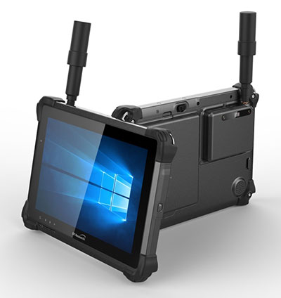
DT301X rugged tablet. (Photo: DT Research)
DT Research has released the DT301X rugged tablet, a lightweight military-grade tablet that is purpose-built to enhance the precision of crime and crash scene reconstruction, bridge and other construction inspections, and 3D surveying.
DT Research made the announcement at Intergeo, being held Oct. 16-18 in Frankfurt, Germany.
The DT301X rugged tablet has MIL spec and IP ratings, yet is lightweight — offering the versatility to be used in the field, office and vehicles, the company said. A high brightness 10.1-inch touchscreen offers flexible viewing in a wide range of lighting, and an Intel eighth-generation Core i5 or i7 processor offers high-performance while still being energy-efficient.
With high-capacity 60- or 90-watt hot-swappable batteries, the DT301X keeps working continuously, complemented with a variety of battery chargers so fully-charged batteries are always available.
The DT301X integrates the Intel RealSense depth camera, which provides real-time 3D imaging to shorten the workflow and create extremely accurate measurements for CAD, engineering, design, utility management and crime-scene forensics.
Scientific grade data, which is important for court evidence as well as building plans, just got easier and is now available to a wider group of workers. With this 3D camera technology, depth perception is integrated to add the most accurate image to make projects stay factual and consistent, DT Research said.
Optional data capture offered on the DT301X besides the 3D camera are a 2D barcode scanner for equipment/location tags, a dual-frequency GNSS module for real-time mapping and positioning, long-range Bluetooth for 1000-foot range, and 4G LTE mobile broadband for the latest in high speed communications.
The rugged tablet gives detailed accuracy combined with the latest 3D camera technology all in one device that is rugged and easy to use in the field.
“DT Research’s high-performance rugged tablet equipped with the RealSense depth camera combined with DotProduct’s Dot3D Scan software allows speedy and efficient field-to-office 3D workflows for a wide range of applications from construction verification to asset management to crime scene mapping,” said Tom Greaves, chief marketing officer at DotProduct.
The DT301X is built to operate in real-world situations, with an IP65 rating for water and dust, MIL-STD-810G for shock and vibration protection, and MIL-STD-461F for EMI and EMC tolerance. The tablet can be paired with a detachable keyboard for ease of use, and Wi-Fi and Bluetooth for smooth networking and constant communications.
The DT301X rugged tablet is compatible with existing applications with Microsoft Windows 10 IoT Enterprise operating systems for flexible integration, and it brings together the advanced workflow for data capture, accurate positioning and data transmitting.
Whether at the electrical substation, at the crash scene, or at the construction site, the DT301X is ideal for accurate measurements as well as other needed tasks, able to travel to wherever the work is.
The DT301X rugged tablet will be available in November 2018 from DT Research’s authorized resellers and partners.
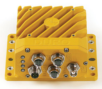
Duro Inertial is a ruggedized version of Swift Navigation’s Piksi Multi dual-frequency real-time kinematic (RTK) GNSS receiver combined with CRL’s SmoothPose sensor fusion algorithm, which fuses GNSS and inertial measurements into a combined solution.
The blending of GNSS and inertial measurements provides a dead-reckoning capability that allows Duro Inertial to provide a highly accurate, continuous position solution during brief GNSS outages and to deliver a robust precision navigation solution in harsh GNSS environments.
Duro Inertial is an evolution of Swift and CRL’s first joint product, Duro. Building on the on-board MEMS inertial measurement unit (IMU) that exists in Duro today, Duro Inertial harnesses CRL’s loosely coupled (LC) sensor fusion algorithm, SmoothPose, to blend GNSS and inertial inputs, providing a smoother, more available and more robust position, velocity and time (PVT) solution, the companies said.
Duro Inertial seamlessly blends CRL’s SmoothPose GNSS+INS algorithms with Swift Navigation’s Starling Positioning Engine to deliver a highly-accurate LC positioning solution even in GNSS / RTK denied environments.
The inertial aiding feature can operate with RTK, autonomous GNSS and satellite-based augmentation system (SBAS) position solutions from Starling. Duro Inertial also inherits the full set of features from Duro and Piksi Multi including the light-weight SBP communication protocol, interoperability with legacy protocols such as NMEA output and RTCMv3 input, compatibility with RTK corrections services such as Skylark, Swift’s Cloud Correction Service and many third-party corrections services, and quad-constellation dual-frequency RTK navigation.
The combination of Duro Inertial’s positioning accuracy and its ruggedized enclosure that protects against weather, moisture, vibration, dust and water immersion makes it suitable for construction, mining, logistics, positive train control, robotics and agriculture applications.
“We are excited to introduce our second collaboration with Carnegie Robotics and build on the success of the Duro ruggedized receiver launched last year,” said Timothy Harris, co-founder and CEO of Swift Navigation. “The combination of Carnegie Robotics’ advanced inertial technology and robotics expertise with Swift’s positioning solution will enable an even broader customer segment to benefit from highly-accurate positioning.”
“Duro Inertial is the culmination of our partnership with Swift over the past two years,” added John Bares, CEO of Carnegie Robotics. “Working together we are able to deliver a consistent and highly-accurate positioning solution to benefit a variety of robotics and industrial applications.”
Duro Inertial is scheduled to be available at for purchase in the fourth quarter and is now available for select customer testing.
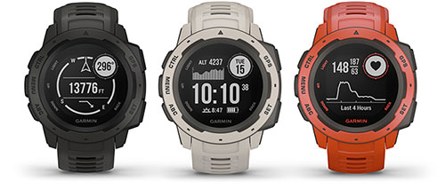
Garmin is now offering a GPS, GLONASS and Galileo watch called Instinct. Instinct is a strong and durable watch with GNSS support, plus built-in 3-axis compass, barometric altimeter and wrist-based heart rate sensor.
The watch includes a built-in sports apps, smart connectivity and wellness data.
Photo: Garmin
“We are thrilled to add Instinct to our adventure watch lineup, an approachable smartwatch that is rugged and reliable,” said Dan Bartel, Garmin vice president of global consumer sales. “Instinct is perfect for those who spend their time outdoors and demand a device built tough to stand up in the elements.”
The Instinct is built to endure challenging environments, constructed to military standards (MIL-STD-810G) for thermal, shock and water resistance (rated to 100 meters) with a fiber reinforced polymer case. The chemically strengthened and scratch-resistant display is readable in direct sunlight, and the fully vented silicone bands include two independent, removable keeper loops to ensure a secure fit.
The multi-GNSS feature helps users track their location in challenging environments. The Garmin Explore app helps plan the trip in advance, and the TracBack feature can navigate the same route back to the starting point.
The built-in heart-rate sensor helps monitor heart rate, steps taken, distance traveled, calories burned and more.
Hexagon’s Geospatial division has launched its total population and housing census management and workflow solution, HxGN Smart Census.
HxGN Smart Census makes each phase of the census process smarter and more manageable, the company said. HxGN Smart Census pricing is agile, taking into account a nation’s surface area, population, and Human Poverty Index to ensure that all countries can participate in the digitalizing of their census processes.
Image: Hexagon
HxGN Smart Census integrates traditional GIS functionality with a powerful workflow and workforce management tool to provide a total solution for census strategies: from pre-enumeration mapping, to digital enumeration, to post-enumeration dynamic mapping. It can be used on its own or integrated with a nation’s or organization’s existing GIS infrastructure.
The solution was developed in consultation with South African GIS experts GeoSpace International, and has already been procured by South Africa and Botswana.
“With HxGN Smart Census, the census gets completed much faster, and the mobile application has made things much simpler for the field workers who are conducting the interviews,” said Shonisani Maranda, senior GIS officer at Statistics South Africa. “It also significantly increased the data quality, which allows us to achieve the UN sustainable development goals more easily.”
“Census data informs policy development, the running of public services, and the allocation of resources within a country. It is vital that all nations are able to utilize the right technology to ensure an accurate and effective census,” said Mladen Stojic, president of Hexagon’s Geospatial division. “HxGN Smart Census is capable of democratizing the collection of accurate demographic data, and transforming this information into insights to make informed decisions to shape Smart Change.”
Caliper has released a free average annual daily traffic (AADT) map layer for Maptitude 2018 users.
The latest version includes fields with total AADT traffic count, semi-trailer truck count, single-unit truck and bus count, number of through lanes and road classification.
AADT is the total volume of vehicle traffic on a highway or road for a year divided by 365 days. It is a useful and simple measurement of how busy a road is, and is useful for:
selecting a new site or facility location, evaluating a site, or designing a territory
determining funding for highway maintenance and improvement
forecasting road maintenance needs and expenditure
identifying the best location for your business based on traffic patterns
analyzing how traffic may impact store construction
analyzing the environmental hazards of sound and pollution related to road transport
The downloaded layer can be added to any Maptitude 2018 map.
GIS software company Caliper has released new highway exit data for the United States and Canada.
Users of Maptitude 2018 with the Canada or United States country packages can download a free point layer containing all signed and numbered highway exits within their respective country.
The highway exits layer allows users to find the nearest highway interchange to a particular location or determine proximity to a desired interchange. Applications include site location assessment, commercial real estate, franchise development and accessibility studies.
The data can also be used in conjunction with the free U.S. traffic count data to determine traffic volumes around a chosen exit.
The Highway Exits and Interchanges layer can be added to any Maptitude 2018 map.
A roundup of recent products in the GNSS and inertial positioning industry from the October 2018 issue of GPS World magazine.
OEM
Anti-spoofing
Provides mitigation and reporting
Photo: Regulus
The Pyramid GNSS allows detection, mitigation and reporting of spoofing of the GNSS system, while still providing accurate positioning (jamming protection will be available in a future version). Version 2 of the Pyramid GNSS adds a software-only version, making it available to numerous applications and enabling GNSS to perform seamlessly under spoofing and jamming conditions. The device is designed for any system depending on GNSS navigation or precise timing, including cars, drones, ships, robots, financial institutions and stationary infrastructure, such as power plants and power grids. The Pyramid GNSS connects externally and integrates seamlessly with existing GNSS receivers, adding reliability and protection to the system. It offers full GNSS support including for BeiDou, Galileo and GLONASS.
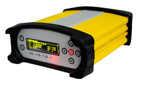
Swift Navigation has upgraded the firmware of its flagship product — the Piksi Multi GNSS receiver. This marks the sixth major release to Piksi Multi since it was launched in February 2017. The upgrade is available free of charge to Swift customers. The firmware release also enhances Duro, the ruggedized version of the Piksi Multi receiver housed in a military-grade, weatherproof enclosure for long-term outdoor deployments. Firmware Release 2.0 for Piksi Multi and Duro supports two additional major satellite constellations — Chinese BeiDou (B1/B2) which, once completed, will contain 37 satellites, and Europe’s Galileo (E1/E5b), which will eventually consist of 30 satellites. Piksi Multi’s performance will further improve for future satellites. The addition of BeiDou and Galileo creates more robust positioning in a variety of challenging sky-view environments.
The G300D gyro is a three-axis, inertial rate system gyroscope. Measuring 0.67 cubic inches, it features low power and high speed, making it suitable for image stabilization applications. The G300D has message timing under 150 microseconds and output data rates up to 8 kHz with external sync. A micro-electro-mechanical gyroscope, it has an ARW of <0.0028 degrees/sec/√Hz and an option for both 24 and 32-bit LSB for exceptional resolution. Users can configure the G300D using a software development kit or through software protocols to simplify the integration process. The G300D gyro is non-ITAR.
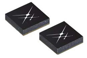
Two new GNSS low-noise amplifier (LNA) front-end modules, the SKY65933-11 and SKY65943-11, integrate Skyworks’ proprietary TC-SAW filters. The modules are designed specifically for internet of things (IoT) applications including smartwatches, action cameras, drones, asset trackers and personal navigation devices. They are designed for wireless module and IoT device manufacturers, providing a turnkey GNSS connectivity solution in a compact form factor. Both solutions offer integrated pre- and post-filter LNA and matching to reduce printed circuit board (PCB) area versus a discrete implementation; single DC supply for design flexibility and simplicity; multi-GNSS compatibility to cover GPS, GLONASS, Galileo, BeiDou and QZSS receiver applications in the 1559–1606 MHz frequency range; extremely low leakage current (1 uA max) benefitting battery-powered IoT devices; and highly manufacturable and low-cost surface-mount technology in a 2.5 x 2.5-millimeter multi-chip module package.
The Net20 Pro provides high-quality data for users interested in the proximity and reliability of a reference station while eliminating real-time kinematic (RTK) corrections service charges. It uses multi-frequency, 555-channel technologies in a rugged casing to deliver accurate and effective positioning data even in harsh environments. It can be configured for correction data reception in client mode to calculate a fixed RTK position and to monitor the antenna position while continuing to work as a GNSS reference server. With NTRIP Caster software, the Net20 Pro provides superior connectivity with an unlimited number of mount points. Users can have permanent transmission of RTK corrections with a local internet connection. Its 32-GB internal and 32-GB external memory is enough for permanent recording even at a 100-Hz high data sampling rate. Its web user interface features upgrade, status and settings management as well as data downloading via smartphone, tablet or other internet-enabled device.
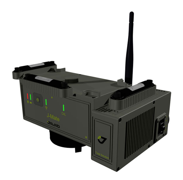
The J-Mate measurement module combines conventional measurement via laser scanning and photographic imagery with the multi-constellation location accuracy of the Triumph-LS receiver. It utilizes precision horizontal and vertical encoders for angular measurement, while the high-definition camera and laser module combine to locate the USB-powered target for accurate measurements. The target rests on top of the receiver and lights up for better visibility to the camera and sensor. The lighting power comes through the USB cord connected to the receiver. Coupled with the onboard data collector screen of the Triumph-LS, operation of the module is done visually with the LS mounted on top of the module or remotely on the J-Pod pole used for GNSS data collection. The module and software is also designed to be an efficient staking application.
The Trimble R10 Model 2 GNSS System is designed to help surveyors work more effectively by enabling reliable, fast and accurate data collection in the field. Enhancements in Model 2 include a custom Trimble survey GNSS ASIC with 672 GNSS channels including GPS, GLONASS, BeiDou, Galileo, QZSS and IRNSS as well as the full range of SBAS. It also will support planned GNSS signals. It has improved reliability against interference and spoofed signals, improved power management by 33 percent, and increased internal memory (6 GB) to store more than 10 years of raw observations. Support for Android and iOS platforms allow field crews to use their own mobile devices. The Trimble R10 Model 2 supports the recently released Trimble TSC7 controller and Trimble Access 2018 field software.
The TerraStar-C PRO correction service provides multi-constellation support, including GPS, GLONASS, Galileo and BeiDou. Combined with NovAtel’s OEM7 positioning technology, TerraStar-C PRO cuts initial convergence times by nearly 60 percent and offers 40 percent better horizontal accuracy than the current TerraStar-C service. In challenging signal conditions, it offers multipath, shading, interference and scintillation. High-rate TerraStar-C PRO corrections provide reconvergence in less than 60 seconds following brief GNSS signal interruptions. Corrections are generated using TerraStar’s proprietary global network of more than 100 GNSS reference stations. The data is delivered worldwide through overlapping geostationary satellites directly to a NovAtel receiver or via cellular IP network.
The C3UBE Command Center enables unmanned beyond-visual-line-of-sight (BVLOS) data collection and near real-time data streaming from almost any point within any critical infrastructure network. The mobile command and distribution center allows for the flight of unmanned aerial systems and is designed to not only allow AviSight to reach the maximum BVLOS distances permitted today, but also to expand its range for UAS operations as limits increase in the national airspace. In addition, it enables near-real-time transmission of data and imagery, which can be disseminated live to anywhere in the world via its proprietary distribution network located at Switch’s Tier 4 data center. It is aimed at the oil, gas, power, transportation and telecommunications sectors.
SimActive has updated its Correlator3D end-to-end photogrammetry software to include tools for users to generate precise statistics on mining activities, with improved volumetric calculation. The integrated tools allow users to generate precise statistics on mining activities. The Correlator3D software performs aerial triangulation and produces dense digital surface models, digital terrain models, point clouds, orthomosaics and vectorized 3D features. Applications like mineral extraction monitoring can be done seamlessly within the software. Users can process raw drone data, produce point clouds and DSMs, and perform volumetric calculations in the same Correlator3D workflow.
The improved TruPulse 360 laser features LTI’s TruVector 360° Compass Technology. The rangefinder measures slope distance, inclination and azimuth; instantly calculates horizontal and vertical distances; and calculates 3D missing line values. The enhanced device offers 33 percent increased distance accuracy, 25 percent better target acquisition and a higher azimuth accuracy of 0.5° root mean squared (RMS). Other features include reflectorless technology that enables data capture to any surface type; advanced targeting modes to achieve accurate, repeatable results of the intended target; seven-power superior optics technology that displays all measured and calculated solutions; and smart technology that recognizes adverse measurement conditions and prompts recalibration. Uses include forestry, utilities, construction and GIS mapping.
Synthetic aperture radar imagery from Maxar’s MDA RADARSAT-2 satellite is now available to SecureWatch subscribers. SecureWatch is DigitalGlobe’s powerful, cloud-based geospatial intelligence platform. The service has added the radar imagery to its high-resolution optical imagery, enabling defense and intelligence analysts to deliver actionable insights to decision makers regardless of weather and light conditions. The satellite will refresh hundreds of global sites on a weekly basis using a wide-ultra-fine format (3-meter resolution, 50-kilometer scene width). RADARSAT-2 imagery allows users to observe features and changes that go undetected using other imaging techniques, and provides day and night coverage regardless of weather. SecureWatch users can access timely RADARSAT-2 imagery using current subscription plans. When combined with 30-cm optical imagery, analysts will have a powerful and reliable toolset to make decisions with confidence.
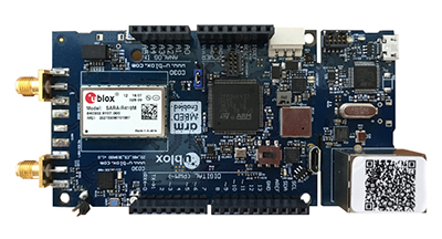
U-blox has introduced a toolset comprising the u-track software and the C030-R410M application board. The toolset is a rapid-prototyping platform that lets product designers test and optimize the position accuracy and power consumption of wireless location tracking applications that use LTE-M and NB-IoT cellular networks, as well as GNSS technology. The toolset targets product engineers working on battery-powered applications such as sport, people and asset trackers. An increasing number of battery-powered consumer and industrial products feature integrated GNSS receivers. These products include virtual reality headsets, smartwatches and devices to track elderly people, containers or parcels. With the ongoing roll-out of low power wide-area cellular networks (LPWAN) such as LTE-M and NB-IoT technologies around the world and the extremely low power consumption they enable, the range of use cases for wireless location trackers is expected to expand further. The u-track software runs from embedded firmware on the new u-blox C030-R410M application board. The board, specifically designed to rapidly prototype applications for the internet of things (IoT), includes an ultra-small, low-power u-blox ZOE-M8B GNSS receiver and a size-optimized SARA-R410M LTE-M/NB-IoT cellular communication module, and u-track includes a PC software application that lets users log, retrieve, and visualize power consumption, accuracy, and other important values, such as the GNSS time to first fix.
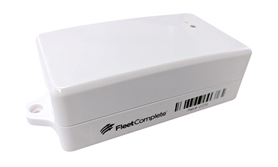
Add-on to AT&T Fleet Complete platform or for separate use
Photo: AT&T
The new GPS Asset Tracker One (AT1) from AT&T and Fleet Complete can track transportation as well as agriculture, food services, pharmaceuticals and emergency services. Users can monitor their assets through the Fleet Complete mobile app. Besides tracking location in near real-time, it also captures humidity, temperature, light exposure and more. AT&T’s nationwide LTE-M network is designed for devices that require low-cost, extended battery life, coverage underground and inside buildings, and carrier-grade security. Two high-capacity Lithium AA batteries power the AT1. They can last up to five years with a once-a-day use.
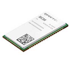
The MC90 is a quad-band GSM/GPRS/GNSS/Wi-Fi module that supports hybrid positioning technologies including GNSS, Cell ID and Wi-Fi aided positioning. It integrates the multi-GNSS system, including GPS, GLONASS, Galileo and QZSS, which makes it suitable for urban areas with high-rise buildings and complex environments. The MC90 also adopts Wi-Fi hotspot positioning technology for blind spots and satellite coverage. It integrates multi-aiding positioning technologies to offer customers with optimized GNSS performance. It also supports EPO technology, which provides predicted Extended Prediction Orbit to speed up TTFF without the need of an extra server. The MC90 features a compact design and lower power consumption, and supports dual SIM single standby function.
TomTom will offer free maps and traffic tiles on its mobile software developer kit (SDK) in both Android and iOS. With global coverage, the Mobile Maps SDKs and its free map tiles will guide developers of mobility and ride-sharing apps. The TomTom Maps APIs (application programming interfaces) also play a role in the internet of things, where traffic data is needed to enable self-driving cars and smart city planning.
MAGNET Inspect is designed for UAV data collection. (Photo: Topcon)
MAGNET Inspect software is designed to facilitate the data-processing workflow for UAV (unmanned aerial vehicle) infrastructure inspection by efficiently managing large UAV data sets to create inspection reports. It allows operators to visually navigate UAV photos, aligning 3D reality meshes with raw georeferenced images in one location and filtering them based on selected criteria including field of view. When combined with Intel Falcon 8+ Drone – Topcon Edition and Topcon ContextCapture, powered by Bentley Systems, the software enables operators to navigate, annotate and create reports with inspection photos, creating a strong end-to-end inspection workflow.
Site Scan Esri Edition is a custom version of the Site Scan iOS app for drone flight planning and data capture that works seamlessly with Esri’s ArcGIS Online and Drone2Map for ArcGIS. The Site Scan Esri Edition app complements Esri’s Drone2Map for ArcGIS software by providing full drone project mission planning and a simple workflow for transferring drone captured data into Esri ArcGIS. Users will be able to connect to ArcGIS Online with an Esri sign-in. The app will allow users to directly use Esri data layers from ArcGIS Online as base and reference data for their drone flight planning mission. Esri customers can use any drone supported by Site Scan, including a variety of DJI drones. Site Scan also supports a custom version of the new Yuneec H520 commercial drone by 3D, which is based on the Dronecode PX4 software and designed to be an open and secure drone option for use on U.S. government projects.
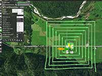
UAS mission-planning software company UgCS has joined with disaster response expert Airborne Response to develop a comprehensive search capability for drones. The search-pattern software, a new feature of the UgCS platform, allows remote pilots to more effectively conduct search-and-rescue operations. Customizable search patterns such as the “expanding square” and “creeping line” can be deployed. Based on the flight altitude input by the operator, the UgCS software will automatically calculate the course heading and track spacing necessary to provide the prescribed coverage area for a search target. UgCS software allows central management of all types and manufacturers of unmanned vehicles, enabling a user to control one or a fleet of drones on a single mission in multi-operator mode and multi-platform environments. Airborne Response will offer the UgCS mission planning software and associated training to public safety and emergency response professionals throughout the U.S.
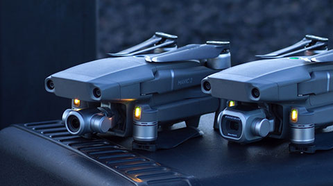
The Mavic 2 Pro is designed for professionals, aerial photographers and content creators. With a folding design, the Mavic 2 is a powerful platform with new gimbal-stabilized cameras and advanced intelligent features like Hyperlapse and ActiveTrack for easier and more dynamic storytelling. Flight time is 31 minutes. Co-engineered in partnership with Hasselblad, the Mavic 2 Pro houses a 1-inch CMOS sensor with a 10-bit Dlog-M color profile. It can capture 20-megapixel aerial shots with utmost color accuracy using the Hasselblad Natural Color Solution (HNCS) technology, while an adjustable aperture from f/2.8-f/11 provides control across a wide variety of lighting conditions.
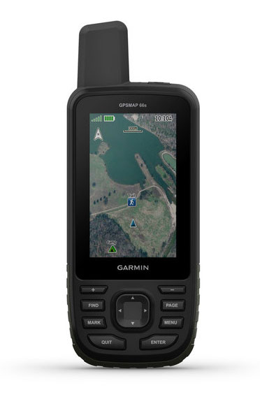
Garmin International is offering a new outdoor GPS handheld that can log raw measurements in RINEX form, the GPSMAP 66.
“We’ve had good success achieving carrier-phase ambiguity resolution with the unit, and I suspect many readers will be interested in this feature from a purpose-built device,” said Jared Bancroft, GNSS sensors & algorithms, Garmin, in an email to GPS World. “We’ve observed accuracies down better than 30 centimeters.”
The GPSMAP 66 is a premium outdoor handheld with expanded wireless connectivity, direct-to-device access to BirdsEye satellite imagery and a 3-inch sunlight-readable color display. The handheld comes in two models, the GPSMAP 66s and GPSMAP 66st. The latter offers preloaded topographic maps for U.S. and Canada.
Professionals and serious GPS enthusiasts will appreciate the inclusion of RINEX data logging, which allows for sub-meter accuracy of GPS position after post processing, Garmin stated in a press release.
“The GPSMAP 66st builds on the GPSMAP series heritage by adding new and requested features like a bigger screen, weather forecasting and easy direct-to-device access to satellite imagery,” said Dan Bartel, Garmin vice president of global consumer sales. “Between multi-GNSS network support and connectivity to the new Garmin Explore app, the new GPSMAP 66s and the GPSMAP 66st are reliable companions for any adventure.”
The handheld can receive weather updates for real-time forecast information by being paired via Bluetooth to a compatible mobile device. It will also provide predictive maps for temperature and wind speed/direction, as well as live weather radar.
Other new GPSMAP 66s/st connected features include Geocaching Live and compatibility to the Connect IQ platform, giving users access to 9 million trails through the preloaded Wikiloc app. The devices all pair with the inReach Mini, allowing the user to send and receive messages directly on their 66s/st device via the Mini.
Between the multi-GNSS satellite support and altimeter, barometer and compass sensor capabilities, the GPSMAP 66s/st will track an entire journey. The handheld devices have 16 hours of battery life in full GPS mode and can track the user’s position for up to one week using Expedition mode on a single set of AA batteries, the company said.
The devices include an LED flashlight and SOS beacon that can be used to signal for help. It is built to military standards for thermal, shock and water performance (MIL-STD-810G).
U-blox is collaborating with LynQ, which developed a location tracker that doesn’t use cellphones, networks, apps or monthly fees. By syncing up the devices before heading out, group members can find each other within a five-mile radius and link up again.
LynQ surpassed its fundraising target on the Indiegogo crowdfunding platform, raising more than $1.5 million, and is now on pre-sale.
The device uses the u-blox CAM-M8Q GNSS receiver, a GPS/GLONASS/BeiDou positioning module with an embedded antenna. With its slim size of 9.6 x 14 x 1.95 millimeters, it is easy to integrate it into handheld devices, u-blox said.
The first generation of the weather-proof tracker uses long-range, low-power radio frequencies to connect devices. Up to 12 people can join a group, split up, and use the only button on the clip-on device to toggle through the group members and find out in which direction and how far away each one is.
LynQ’s crowdfunding success shows the extent to which the company’s founders uncovered an unmet demand on the market. While smartphone-based solutions to locate friends and family, for instance in a crowd, abound, they are limited by the availability of mobile network reception.
LynQ’s location tracker helps friends regroup outdoors or at crowded events, parents keep an eye on their children, and caregivers watch over the safety of people with special needs, elderly family members, or loved ones suffering from diseases such as Alzheimer’s.
The tracker has been field-tested on numerous continents and in most topographies and use cases.
“We found the u blox CAM-M8Q to be the best solution for us to achieve the requirements our use cases demand,” said Drew Lauter, COO at LynQ. “We’re extremely price sensitive, yet we need a highly dependable GPS module; u-blox worked closely with us to deliver that.”
For u blox, accompanying LynQ in the development of its product has been an exciting adventure, said Suresh Ram, president of u-blox America. “We’re thrilled to see how well their idea has been received by the public and look forward to our continued collaboration in the future.”
Quectel Wireless Solutions, a global supplier of internet of things (IoT) modules, has launched the EG18, an LTE Category 18, high-speed module that offers 1.2Gbps downlink and 150Mbps uplink peak rates.
EG18 module. (Photo: Quectel)
The EG18 supports Qualcomm IZat location technology Gen8C Lite (GPS, GLONASS, BeiDou, Galileo and QZSS). The integrated GNSS greatly simplifies product design, and provides quicker, more accurate and more dependable positioning capability, Quectel said.
Based on Qualcomm’s SDX20 chipset and fully compliant with 3GPP R12 specification, EG18 supports wireless technologies such as carrier aggregation (CA), 4×4 multiple-input multiple-output (MIMO) technology and 256QAM.
Quectel EG18 is a series of LTE Advanced modules optimized specially for M2M and IoT applications which support industrial operating temperature range of -40 to 85˚C.
The EG18 is designed for ultra-high-speed industrial routers, in-vehicle video surveillance systems, cloud-based 4K IP-cameras and other applications that require very high throughput and low latency.
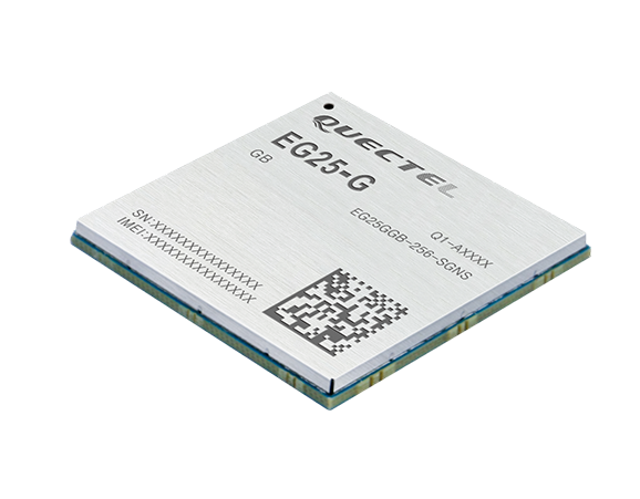
EG25-G module. (Photo: Quectel)
EG25-G module. Quectel also launched an LTE Cat 4 module to provide global connectivity on up to 30 bands with LTE, 3G and 2G coverage all from a single SKU. This “all-in-one” module EG25-G is designed to improve the efficiency of global IoT deployment at optimized cost.
EG25-G is the latest addition to Quectel’s comprehensive LTE portfolio based on Qualcomm MDM9x07 chipset. Adopting the 3GPP Release 11 LTE technology, it delivers 150 Mbps downlink and 50 Mbps uplink peak data rates, with an optional GNSS receiver including GPS, GLONASS, BeiDou, Galileo and QZSS to provide quick and accurate positioning, the company said.
The new module supports FDD LTE frequency bands of B1/B2/B3/B4/B5/B7/B8/B12/B13/B18/B19/B20/B25/B26/B28, TDD LTE bands of B38/B39/B40/B41, WCDMA bands of B1/B2/B4/B5/B6/B8/B19 and quad-band GSM/EDGE. This ensures devices with EG25-G inside can operate on networks of major global carriers like AT&T, Verizon, Telstra, Vodafone and T-Mobile. The EG25-G supports multi-carrier switch by detecting (U)SIM card.
Designed in a compact LGA form factor measuring 29.0×32.0×2.4 mm, EG25-G is pin-compatible with Quectel’s EC2X family, allowing flexible migration. It also offers Mini PCIe form factor with built-in sim card holder to provide a better plug-and-play experience.
“A growing number of today’s IoT developers tend to design and manufacture devices that can operate globally with a single hardware design. Our EG25-G was created to address such needs,” said Delbert Sun, Quectel product and marketing director. “We are pleased to see that customers will achieve simplified production and testing processes, and save distribution costs due to the need for just one single SKU.”
EG25-G has a rich set of Internet protocols, industry-standard interfaces, abundant functionalities and extended life cycle, and is designed for verticals including industrial routers, industrial PDA and video surveillance.
Europe-based Airbus Defence and Space has entered into a partnership with Orbital Insight, a U.S.-based geospatial analytics company, to build a suite of geospatial analytics services and tools.
The agreement will provide Orbital Insight with access to Pleiades and SPOT satellite imagery at scale, and provide Airbus with analytics services, making Orbital Insight the first analytics partner for the Airbus Digital Platform OneAtlas.
The OneAtlas Platform is a collaborative environment enabling users to easily access constantly updated satellite imagery, perform large-scale image processing, extract industry-specific insights, and benefit from Airbus assets to develop tailored solutions for a wide range of markets in both commercial and government sectors, the company said.
“Under this agreement, we will offer premium analytics capabilities to a large range of users, powered by Orbital Insight’s services and tools,” said François Lombard, director of the Intelligence Business at Airbus Defence and Space. “The OneAtlas Platform is definitively the cornerstone to leverage both Airbus and partner assets to support our customers’ business development and growth.”
“We’re proud to be Airbus’ first geospatial analytics partner on the OneAtlas Platform,” said James Crawford, Orbital Insight’s CEO and founder. “Along with our new satellite imagery agreement, this partnership drives customer value for those looking to better understand what’s happening on and to Earth.”
Aerial imagery specialist Spookfish has expanded its capture program into New South Wales (NSW), now covering the NSW coast and Sydney’s entire metropolitan area. Spookfish’s coverage in NSW now spans from Newcastle to Kiama and from Lithgow to Manly.
The expansion into NSW marks the next stage of a nationwide rollout for Spookfish. In the past 12 months, the company has expanded coverage into the South Australian, Victorian, Australian Capital Territory and now NSW markets, in addition to its Western Australian coverage.
The expansion of coverage will give businesses and government agencies across Sydney and regional NSW the opportunity to access high-resolution aerial imagery and save thousands of dollars by reducing the time spent on site.
Spookfish now covers the entire Sydney metropolitan area, home to 71% of the NSW population. The city’s growth presents development opportunities for businesses, all of which need to fit within city planning regulations. High-resolution aerial imagery will play an important role in the planning stages.
Spookfish also captures regional cities and towns, including Albury and Wagga Wagga, at the same consistent specification as capital cities.
With the addition of Perth, Melbourne and Adelaide’s entire metropolitan areas, Spookfish offers users access to more than 55,000 square kilometers of high-resolution imagery across Australia. The platform provides customers a clear view on any device with no data caps to give users access to unlimited high-resolution aerial imagery without the risk of unexpected costs.
“Sydney has the greatest population density in Australia, and continues to grow with new projects commissioned to meet this growing population,” said Jason Waller, Spookfish CEO. “We are very pleased to be able to offer businesses access to high resolution imagery of this unique city, to help drive effective and precise planning of developments and urban areas.
“Every day our platform is being discovered by many Australian businesses, helping them save time and money by providing precise aerial imagery with the timeliness and convenience of cloud delivery. We offer our customers a service like no other, where they can access extremely high resolution images at an affordable price across very large areas, with no data caps.”
Spookfish utilizes a fleet of specialized planes to capture imagery for its platform. With regular updates in capital cities across Australia, customers have an up-to-date and evolving view of their world.