Hexagon’s Safety, Infrastructure & Geospatial division has released for Android defense applications. The platform is designed for the development of mobile applications for dismounted soldiers in the field.
With LuciadCPillar, developers can build applications with 2D and 3D views. It features military symbology and supports many geospatial data types including vector data, raster data, elevation data, point clouds and 3D meshes. It has the same capabilities found in desktops, in-vehicle and browser applications built with LuciadLightspeed, LuciadCPillar and LuciadRIA.
The platform offers capabilities to match high-resolution screens, graphic processing units and multi-core processors including the ability to display 3D data in mobile applications. LuciadCPillar supports ARM processors and an application programming interface, which aligns with the Android developer experience.
Impact, a French system integrator, partnered with Hexagon to test LuciadCPillar and will integrate it into its Delta Suite product, which is used by the French Special Operations Command.
LuciadCPillar is part of Luciad 2022.1, which is available now globally.
A roundup of recent products in the GNSS and inertial positioning industry from the January 2023 issue of GPS World magazine.
SURVEYING & MAPPING
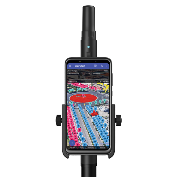
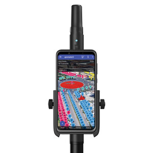
Image: Geometer International
Dual-Frequency Receiver
Receives all GNSS constellations plus SBAS
The Walker RTK is a dual-frequency GNSS receiver (L1, L2) for high-precision coordinate surveying in real-time kinematic (RTK) mode. It comes with a helical antenna, a bracket for attaching a smartphone, and the Geometer SCOUT mobile app. A classic geodesic antenna can be connected through the SMA connector. The Walker RTK has a rugged aluminum alloy casing with a shock-resistant coating, yet weighs only 250 grams. GNSS signals processed by the Walker RTK GNSS receiver include GPS (L1C/A, L2C), GLONASS (L1OF, L2OF), Galileo (E1B/C, E5b), BeiDou (B1I, B2I), QZSS (L1C/A, L1S, L2C) and SBAS (L1C/A). A built-in rechargeable battery provides 24 hours of continuous operation without recharging.
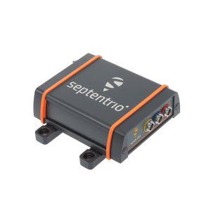
The AsteRx SB3 ProBase creates high-quality measurements for real-time kinematic (RTK) and differential corrections. The IP68-housed GNSS base station receiver features the latest quad-constellation GNSS technology and complements the SB3 receiver family: the AsteRx SB3 Pro rover receiver, the AsteRx SB3 Pro+ rover and base receiver, and the AsteRx SB3 CLAS for the Japanese market. The SB3 ProBase is easy to configure, the company says. It comes with Septentrio’s GNSS+ technologies, including anti-jam and anti-spoofing technology (AIM+) for robustness and reliability. AsteRx SB3 products are pin-to-pin compatible with the AsteRx SB ProDirect receiver and the recently released AsteRx SBi3 GNSS/INS system.
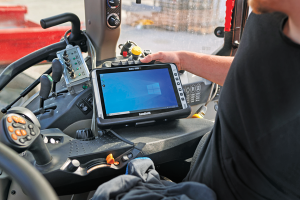
The Algiz 10XR is a rugged 10-inch Windows tablet that combines durability with a GNSS receiver and 5G communications. It was developed for challenging environments in logistics, mining, public transport, public safety, waste management or geographic information systems (GIS). The 10xR is customizable and has a dedicated multiband GNSS u-blox NEO-M8U receiver for accurate positioning as well as untethered dead-reckoning technology. The high-resolution, sunlight-readable 10-inch touchscreen has super-hardened glass and rain-and-glove mode. The tablet also has 4G/LTE high-speed data, Wi-Fi and Bluetooth.
The VZ-600i terrestrial laser scanner has a 3D position accuracy of 3 mm and less than 30 seconds of scan time for high-resolution scans with 6 mm point spacing at 10 m. This enables more than 60 scan positions per hour with real-time registration. Weighing less than 6 kg (13 pounds), the VZ-600i has a 2.2-MHZ pulse repetition rate, three internal cameras and an integrated GNSS receiver. It also includes key features to speed up workflows in indoor and outdoor applications such as architecture, engineering, construction, building information modeling, as-built surveying, forensic and crash scene investigation, archaeology and cultural heritage documentation and forestry.
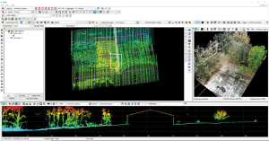
The LP360 Drone software system provides a geospatial-data workflow for UAV lidar and photogrammetry data processing. It provides powerful point cloud visualizations with multiple, synchronized windows. It can transform lidar and imagery data into survey-grade deliverables including visualization, quality checks, classification, analysis and 3D editing. For users of larger datasets, LP360 Geospatial can process captured lidar data or images from any aircraft or mobile sensor and analyze and extract values.
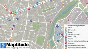
Free library offers data on healthcare, business, traffic
The extensive Maptitude library of free mapping databases has been updated for 2022 and is available for download, supporting insightful business development analysis. The data is available free to users of the latest version of the Maptitude mapping software. The data are also available as shapefile, KML, KMZ or GeoJSON for a fee. Maptitude includes business-critical data such as demographics, boundaries, streets, and the most ZIP Code/postal boundaries. Also available is a catalog of free premium datasets that can be used in other GIS applications, on the web, or in corporate databases.
Indoor and outdoor tracking of low-power, small IoT devices
Traxmate is integrating Nestwave GNSS location technology into its asset-tracking platform for seamless indoor and outdoor positioning, tracking and routing of small, low-power and battery-powered devices for the internet of things (IoT). Nestwave’s NestCore IP and NestCloud cloud services enable power-efficient geolocation solutions, while Traxmate (pictured) is a comprehensive data-processing hub that simplifies setup of tracking environments and provides real-time visualization of device location. The resulting geolocation solution is suitable for applications ranging from carrier tracking to tracking individual parcels and packets. Traxmate is simple to use and set up, requires no coding, and provides an out-of-the-box feature set that includes dashboards, alerts and processing rules for taking actions on incoming data. Nestwave’s trackers include ThinTrack, an ultra-low-profile, compact GPS tracking solution that integrates an LTE-M/NB-IoT modem, antenna, battery and SIM into a device that measures 82 mm x 35 mm x3 mm and weighs 15 g.
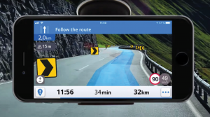
Provides guidance even without an internet connection
The Sygic GPS Navigation app uses a smartphone’s camera and augmented reality to display navigation instructions over the view ahead on the windshield. The head-up display is especially useful at night, enabling recognition of critical speed limit, road work or traffic restriction signs. Cockpit is a powerful tool that shows the real-time performance of the car, measuring the G force and actual speed to help users drive economically. The Dashcam feature records the road ahead and automatically saves the video in case of an accident. An Electric Vehicle Mode locates nearby charging stations.
Enhanced data-based rule implementation for fleets
An enhanced SureCam video telematics integration provides fleet managers with access to new capabilities to keep drivers safe and maximize fleet efficiency. The solution features a method for capturing video footage from SureCam cameras using Geotab’s powerful telematics device and rule-based system. The result is a seamless display of video within the MyGeotab platform. The enhanced SureCam fleet video solution leverages Geotab’s numerous data-based rules, such as improper seat belt usage and speeding. It uses G-force triggered alerts that detect unsafe driving behaviors and automatically captures video footage that can be reviewed later on the MyGeotab platform and alert managers to incidents when necessary. Camera configuration and customized triggers are managed directly within MyGeotab.
Driver 2.0 is a Level 4 production-ready autonomous driving solution that can operate in complex and challenging traffic environments. Demonstrations with Driver 2.0 showed an autonomous vehicle could maneuver around double-parked cars, e-scooters and pedestrians, negotiate oncoming vehicles to calculate the right timing and trajectory to pass busy intersections, and make multiple lane changes and unprotected left turns. In the case of long tail scenarios, the system will alert the remote monitoring center to intervene or take other safety measures. Driver 2.0 includes five solid-state lidar units, eight cameras and other sensors, and a computing platform integrated with a proprietary inference engine. The perception algorithm with sensor fusion can achieve precise object detection up to nearly 220 yards. The planning and control algorithm based on game theory can choose optimal routes and make decisions based on real-time situations when negotiating with oncoming vehicles and other road agents.
Provide improved signal gain for automotive antennas
Two new compounds could improve signal-gain performance compared to ceramics in second-generation automotive GNSS antennas. The new compounds — LNP Thermocomp ZKC0CXXD and LNP Thermocomp ZKC0DXXD — help enable the design and molding of antenna substrates with more complex pattern markings that add effective surface area, a critical factor in enhancing signal capture. They also provide flexibility to produce smaller parts with the same performance as ceramic, or equal-size parts with better performance. The LNP Thermocomp compounds feature electroplating capability, good thermal resistance for reliability, and the design freedom and production efficiency of thermoplastics. Both are well-suited for shark-fin-style and new conformal antenna designs.
SABIC, sabic.com
AUTONOMOUS
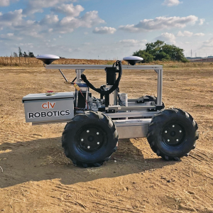
Image: Civ Robotics
Robotic Surveyor
Precisely marks thousands of coordinates per day
The CivDot unmanned ground vehicle (UGV) is designed for civil engineering and infrastructure projects such as solar farms, roadways, data centers, power plants and more. The autonomous surveying robot is designed to increase efficiency, productivity and safety on the job. Augmenting the surveyor’s work, CivDot marks thousands of coordinates per day precisely and efficiently, while delivering layouts faster than traditional methods. Civ Robotics uses Trimble’s high-precision GNSS positioning technology and surveying software.
The compact DJI Mavic 3E and 3T drones have been designed for an array of commercial missions. Flight time is 45 minutes. Both models have a real-time kinematic (RTK) module that enables surveying professionals to achieve centimeter-level accuracy with support for network RTK, custom network RTK services, and the D-RTK 2 Mobile Station. The D-RTK 2 Mobile Station is DJI’s upgraded high-precision GNSS receiver that supports all major GNSS, providing real-time differential corrections. The DJI Mavic 3E enables efficient mapping and surveying missions without the need for ground control points. The DJI Mavic 3T is engineered for aerial operations in firefighting, search and rescue, inspections and night missions.
Cepton has released a new lidar solution, Vista-X120 Plus, which is a slim, software-definable, automotive lidar for real-time adaptive 3D perception. This solution will expand Cepton’s line of commercially scalable Vista-X90 lidar solutions and will be deployed in its advanced driver assistance lidar series production program.
The Vista-X120 Plus includes a software-definable region of interest, which enables higher dynamic perception capabilities. Its adjustable central field of view with increased angular resolution improves accuracy in the detection and classification of objects when driving. The region of interest is also configurable in real time in both horizontal and vertical directions.
The lidar solution is 140 x 30 mm, making it slim and compact. The small size improves OEM integration and placement options without disrupting vehicle appearance.
At its <18 W power consumption, the Vista-X120 Plus offers a 200 m range at 10% reflectivity, 120° x 25° field of view, and a data rate of more than six million points per second.
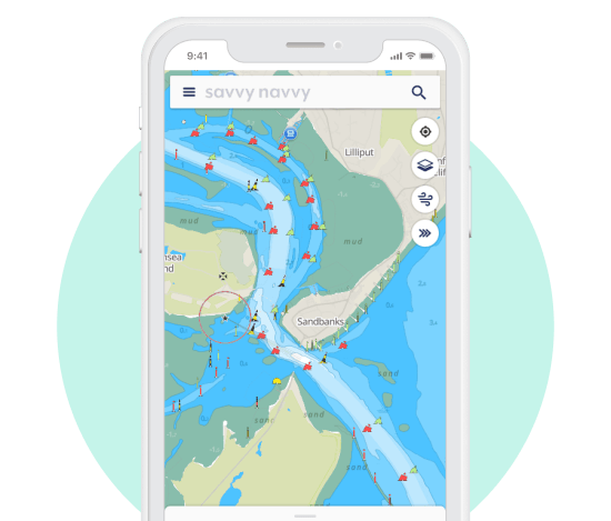
A new partnership between all-in-one navigation app and Waterway Guide gives U.S. boaters an enhanced user experience, integrating comprehensive marina details and user reviews into the navigation app.
The savvy navvy app, described as “Google Maps for boaters”, has grown by 132% this year in the United States.
Waterway Guide is a resource for cruising boaters. Its data on more than 4,000 marinas and thousands of anchorages are now integrated into the savvy navvy app for all the users to access.
“One of the most significant factors in deciding where to go with your boat is reviews from other boaters,” said Jelte Liebrand, CEO and founder of savvy navvy. “With a wealth of information on all marinas and anchorages and honest reviews, it’s an amazing addition to our offering for our growing American customer base.”
Image: savvy navvy
Liebrand, a former Google software engineer and avid sailor based in the UK, developed and launched savvy navvy, bringing an all-in-one navigation solution to the market. This season alone savvy navvy users have plotted more than 40 million nautical miles of routes. Earlier this year, the navigation app launched a freemium plan and functionalities for paddleboarders, kayakers and jet skiers.
Waterway Guide is continuously updated by a network of on-the-water contributors, marina partners, NOAA data, the Waterway Guide team, and crowd-sourced information.
Data from the Waterway Guide is live in the savvy navvy app for users to see now when pressing the blue POI icons across the United States and Canada, giving users information on services and facilities alongside marina reviews.
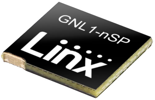
Linx Technologies, now part of TE Connectivity, has expanded on its Splatch antenna series with the release of the ANT-GNL1-nSP, a surface-mount embedded GNSS antenna supporting GPS, Galileo, GLONASS, Beidou and QZSS in the L1/E1/B1 bands.
“The new linear GNSS antenna from Linx expands upon our already robust embedded PCB antenna portfolio of customer favorites like the uSP410, SP610 and the nSP250, by adding a GNSS solution,” said Rick Stuby, vice president of product management. “The antenna displays high performance in a compact surface-mount package, making it especially well-suited for small devices in the growing internet of things market.”
The ANT-GNL1-nSP antenna exhibits notable performance in a compact size (10 mm x 8 mm x 1 mm) and features linear polarization and an omnidirectional radiation pattern. The antenna is available in tape and reel packaging and is designed for reflow-solder mounting directly to a printed circuit board for high-volume applications.
The new GNSS antennas are available now via Linx Technologies’ distributor and manufacturer representative networks. For larger quotes, email Linx Technologies at [email protected].
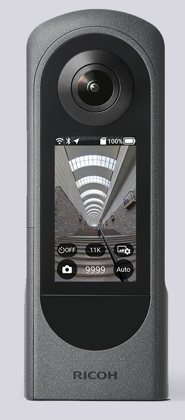
The Ricoh Theta X 360° camera uses a u-blox module for its location metadata. (Photo: Ricoh)
The ZOE-M8B GNSS module from u-blox is integrated into the new RicohTheta X camera. The camera allows users to shoot high-quality 360-degree spherical images and videos in one click and visualize them immediately on an LCD touch panel.
The u-blox ZOE-M8B enables the Ricoh Theta X’s built-in location system, one of its key features. The module is listed on the u-blox site as receiving GPS, BeiDou and GLONASS signals as well as QZSS, but the Ricoh Theta X specifications list only GPS + QZSS along with assisted GPS.
The u-blox receiver automatically embeds highly accurate location information for each image taken, without the need for a smartphone or another external device.
An icon on the LCD touch panel displays the availability of the GPS signals depending on the user’s location, ensuring the location information has been reliably acquired before shooting begins. The location is accurate down to a 5-meter radius, suitable for a wide range of industrial and consumer applications.
The u-blox ZOE-M8B GNSS module is an ultra-small (4.5 mm x 4.5 x 1.0 mm) system-in-package offering highly accurate positioning with concurrent reception of up to three satellite constellations. The Super-E (Super-Efficient) mode guarantees power consumption as low as 12 mW, and built-in SAW and LNA make it suitable for passive antennas. The u-blox ZOE-M8B targets applications that require a small size without compromising performance.
Part of a 360° spherical image shot with the Theta X. (Photo: Ricoh)
“We chose the u-blox module because of the highly accurate location information it offers, alongside easy integration and low power consumption,” said Kenji Daigo, GPS Function Developer for Theta X at Ricoh.
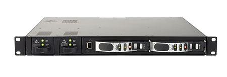
Femtocell cellular base stations used by Global Medical Response (GMR) in their Dallas, Texas, offices are receiving high-accuracy GPS location and timing signals from RF-over-fiber links from ViaLite Communications.
The GPS signals help GMR provide emergency quality medical care at a moment’s notice, primarily in the areas of emergency and patient relocation services in the United States and around the world.
The Local Integrated GPS Splitter. (Photo: ViaLite)
The highly reliable system consists of a ViaLite GPS Link that sends the GPS and timing signals from the rooftop antenna down an optical fiber to a Local Integrated GPS splitter situated in the building. The splitter then distributes the timing data to multiple femtocells.
“The efficiency of ViaLite’s signal distribution techniques is second to none, and in this emergency support application, when action at a moment’s notice can be vital, our equipment’s reliability and performance are crucial,” explained Craig Somach, ViaLite sales director.
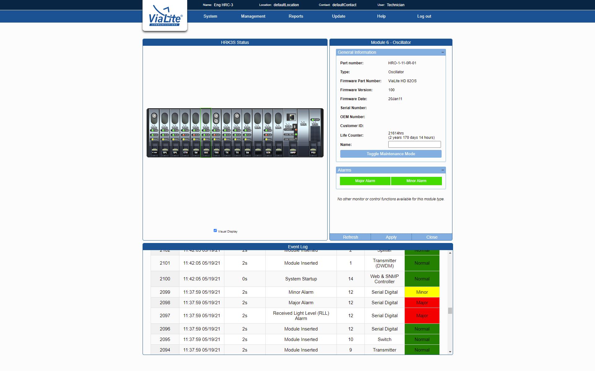
A monitoring and control module is built into the GPS splitter. (Photo: ViaLite)
Use of the high-tech splitter, which features a built-in monitoring and control module, also eliminates the need to install multiple antennas on the rooftop, avoiding the appearance of an antenna farm.
“As a first-time customer, we found the deployment was as smooth and simple as ViaLite had promised,” said Dan Cottom, senior manager of communication systems at GMR. “The GPS distribution is working great.”
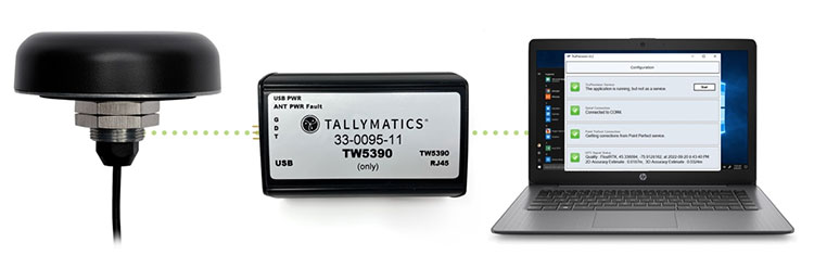
Tallymatics has introduced the TW5390 smart antenna with IP network and L-band augmentation service capability.
Tallymatics is a division of Tallysman Wireless, a Calian company, specializing in of precision geolocation applications and equipment.
To create the TW5390, Tallymatics leveraged its experience in GNSS applications, design and manufacturing, combining Tallysman’s GNSS antenna technology with the high-precision u-blox F9R GNSS receiver and DS9 L-Band receiver modules.
The combination delivers a reliable and convenient smart antenna yielding <6 cm accuracy, with precise point positioning/real-time kinematic (PPP/RTK) augmentation services via the PointPerfect subscription service.
The TW5390 solves the complexities of GNSS design — it sends the host system PPP/RTK corrected coordinates in NMEA format over a robust RS-485 interface, assuring results that meet customers’ high expectations.
Features of the TW5390
simultaneous dual-band coverage for GPS, Galileo, GLONASS and BeiDou
superior multipath rejection with Tallysman Accutenna technology
low noise amplifier
Tallysman’s eXtended Filtering (XF) technology, which mitigates saturation from nearby RF signals (targeting
LTE and Ligado)
tight, measured phase-center offset and low axial ratio, enabling accurate and precise positioning
direct decoding of PointPerfect, SPARTN formatted augmentation packets (u-blox specific)
IP network and L-band augmentation communications channels
built-in inertial measurement unit for UDR and ADR
fast convergence time of 40 seconds (PPP/RTK) with < 6 cm accuracy
IP69K package
RS-485 transceivers
Tallymatics SDK available with computer interface, TruPrecision software and 60 days of free PointPerfect
The new device will ship in the fourth quarter of this year and is available for pre-order
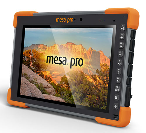
Juniper Systems is entering the 10-inch rugged tablet market with the launch of its Mesa Pro rugged tablet. The Mesa Pro features 11th Generation Intel Core processors, a Windows 11 operating system, device customization options, a large sunlight-readable display and “Juniper Rugged” company design.
“We are excited to be entering the 10-inch rugged tablet segment for the first time,” said Darren Hellstern, the Mesa Pro product manager at Juniper Systems. “Mesa Pro offers powerful processing, a rugged design meant for any environment, and is a versatile workstation that can be used in the office or the field.”
Standard Mesa Pro units come equipped with an 11th Gen Intel Core i5 processor and 16 GB of LPDDR4x RAM. Core i7 and Celeron versions of the device are also available.
Each Mesa Pro configuration offers powerful performance and allows users to select a level of computing performance that best fits their needs while having options that meet their budgets.
“It was important for us to offer performance tiers,” said Hellstern. “This is the first time we have offered various performance levels in one of our devices. The needs that our customers and users have varies greatly. From running CAD programs, viewing construction plans, mapping and mounted-vehicle solutions, we feel that we have an offering with Mesa Pro that fits the processing need of the user. We are also available to help users determine what level of performance they need.”
Mesa Pro joins the current Mesa family of 7-inch devices and helps Juniper Systems achieve its mission of providing powerful rugged computing and data-collection devices to mobile field workers everywhere. The Mesa 3 runs on either Windows or Android operating systems. The Mesa family started in 2010 with the launch of the Mesa Rugged Notepad.
“Mesa devices have served our customers for over a decade,” said Hellstern. “We are proud to add Mesa Pro to that list of incredible devices and offer more options to our customers and users around the world.”
Juniper Systems is now accepting pre-orders for the Mesa Pro.
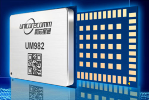
Unicore has released its new generation of GNSS positioning product, the UM982. The UM982 is a high-precision dual-antenna real-time kinematic (RTK) positioning and heading module supporting all constellations and all frequencies.
The UM982 is suitable for use in UAV, precision agriculture and autonomous machine applications. The module is designed to meet the requirements of these markets, providing technological innovation. The module supports BDS B1I/B2I/B3I, GPS L1/L2/L5, GLONASS L1/L2, Galileo E1/E5a/E5b, QZSS L1/L2/L5 and SBAS in dual-antenna mode. It offers the following advantages.
Small size. The UM982 is highly integrated. With its size of 16.0 × 21.0 × 2.6 mm, it is a compact dual-antenna heading modules that reduces the design area of the customer’s board by 72% compared to previous modules.
Low power consumption. Low power consumption means less energy usage and a better application experience. Lowering the power consumption while keeping performance high is one of the key technical research directions of the GNSS positioning modules. The average power consumption of all versions of the UM982 module is less than 0.6 W, which is suitable for applications that require low power consumption, such as UAVs.
High integration. The UM982 was developed on the basis of NebulasIV, Unicore’s proprietary GNSS system on chip (SoC). NebulasIV integrates RF, baseband and high-precision algorithms on a single chip, with built-in functions providing powerful support for the UM982’s high performance.
High precision and high performance. The GNSS SoC is a key part of the navigation system, and the performance of the chip largely determines the performance of positioning modules. High-level performance indicators include raw observation accuracy, RTK positioning accuracy, PPP positioning accuracy, and time to first fix.
Robustness. Using the company’s dual-RTK technology, the UM982’s two antennas can independently participate in deriving an RTK solution and outputting the positioning results. This is convenient for customers conducting reliable verification in various application scenarios. By checking the RTK positioning results of both antennas, abnormal measurements in complex scenarios can be avoided.
High reliability. A built-in, advanced anti-jamming unit provides the UM982 with strong anti-jamming ability. The module detects jamming and can output the jamming strength. It also supports digital encryption to ensure the security of data transmission, and supports multi-frequency independent acquisition and tracking to ensure the reliability and accuracy of positioning results even in complex electromagnetic environments.
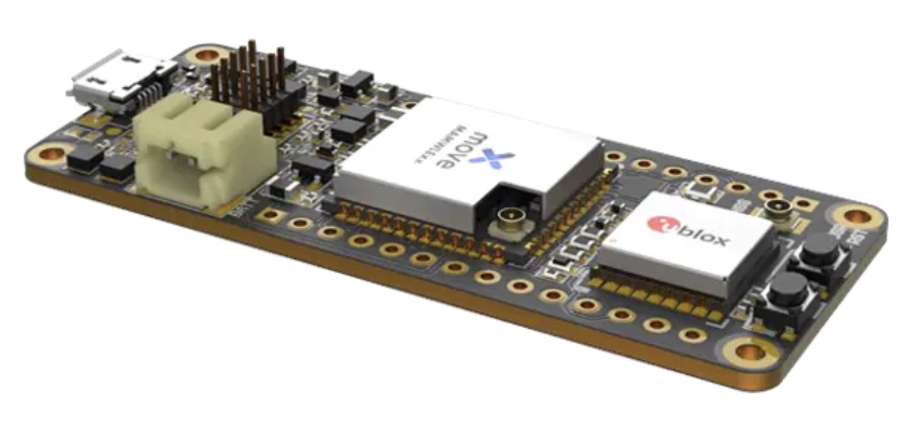
Telecommunication electronics company Move-X is offering a new LoRa/GNSS board. The Cicerone LoRa/GNSS board is a high-performance, low-power, Arduino MKR-compatible development board based on the u-blox MAX-M10S GNSS module and the MAMWLE LoRa module.
The Cicerone board delivers high-performance GNSS, long-range wireless connection, and high-performance MCU processing in a low-power solution for optimal battery life.
The board allows users to build tracking applications worldwide with meter-level accuracy and to communicate long-range, low-power data via LoRaWAN. The integrated Li-Po charging circuit enables the Cicerone board to manage battery charging through the USB port.
The Move-X Cicerone LoRa/GNSS board has a compact 63 x 25 mm form factor and is compatible with all Arduino MKR shield boards. These boards all share a common pinout to enable developers to easily add expansions with minimal software changes.
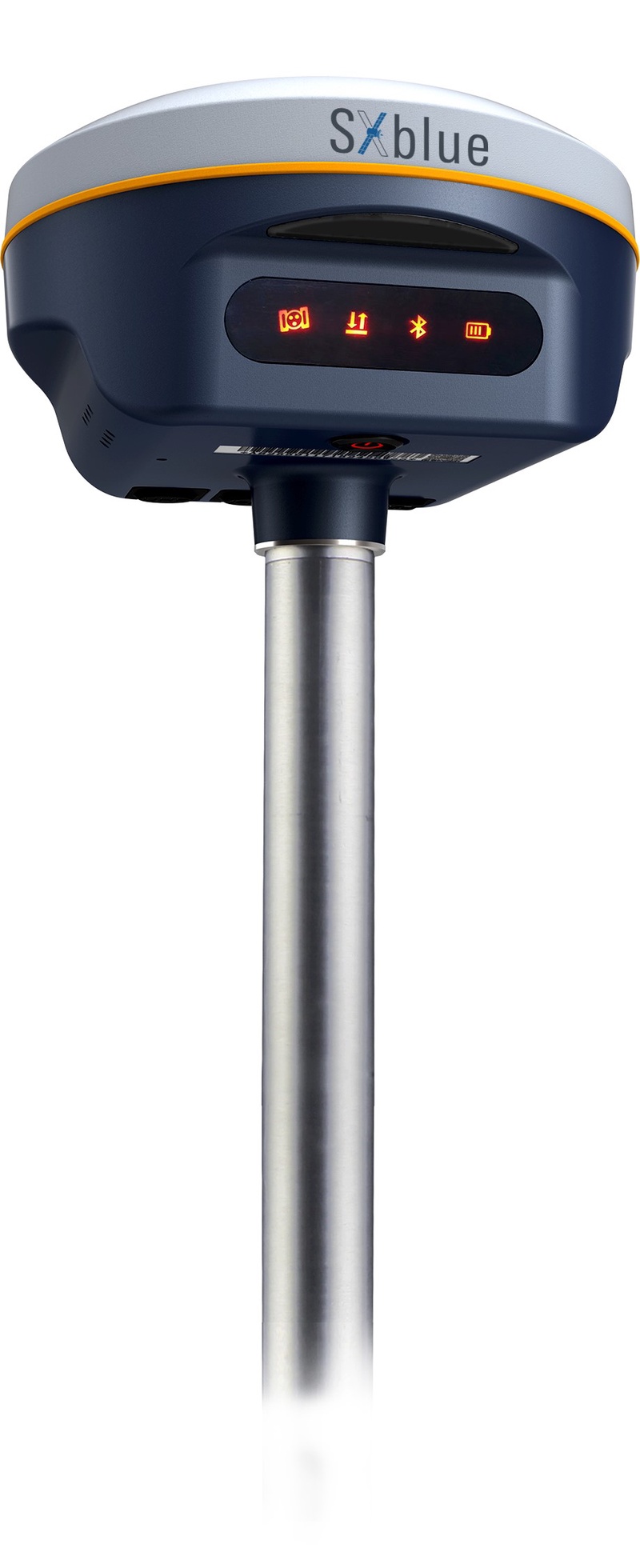
Geneq Inc. has released the SXblue SMART to meet the requirements of professionals looking for an accurate, flexible smart antenna for field work.
The SXblue SMART features a GNSS engine capable of quickly tracking all-in-view GNSS signals. Its design includes interference mitigation technology and optimization for handling a wide frequency band.
Weighing 850 g including battery, the SXblue SMART is compact, supplying the accuracy, ruggedness and maneuverability needed by surveying professionals. Its radio link is based on the Farlink protocol that allows a range of up to 8 km, a performance achievable while reserving a wide bandwidth for transmission of real-time kinematic (RTK) data.
In addition to a tilt sensor for measurements in hard-to-reach places, the SXblue SMART features a high-performance attitude measurement module that can detect and measure movement of the device. An integrated inertial measurement unit provides even more accurate and stable measurements and increased productivity. The SXblue SMART also has a built-in thermometer for monitoring and controlling its internal temperature.
Compared to the company’s previous products, the SXblue SMART has improved communication features, including near-field communication that facilitates close communication with a controller or mobile phone equipped with this technology.