Tag: product showcase

  • Trimble introduces high-accuracy mapping solution for GIS field applications

    Trimble introduces high-accuracy mapping solution for GIS field applications

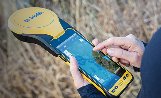
    Trimble has announced a new high-performance data collector for its Mapping and Geographic Information Systems (GIS) portfolio — the Trimble TDC650 handheld. Built for GIS data collection, inspection and asset management activities, the TDC650 provides users a rugged solution with scalable high-accuracy GNSS positioning for professional field workflows.

    The TDC650 is fully integrated with today’s demanding GIS data environment, powered by the Trimble Software Development Kit (SDK) that enables precision GNSS positioning for apps such as Esri ArcGIS Field Maps and Trimble TerraFlex software. The TDC650 is also a scalable solution that allows customers to choose their desired accuracy down to the centimeter-level to meet needs and budget requirements.

    “This is an ideal tool for customers tasked with modernizing critical utilities including electric, gas and telecommunications networks,” said Gareth Gibson, marketing director, Trimble Mapping and GIS. “The precision, quality and data integration workflows needed to map the physical world to a digital one in these projects requires a modern data-collection platform like the TDC650.”

    City, state and local governments and utilities will benefit from this solution, which is part of the larger Trimble Public Sector ecosystem that includes Cityworks software for stormwater inspections and Trimble Unity for monitoring municipal water pressure and hazards. As GIS data continues to grow more complex, Trimble helps simplify, visualize and make sense of the data so customers can make better decisions in managing their communities’ assets.

    Photo: Trimble
    Photo: Trimble
  • Tallysman adds housed TW3885T dual-band timing antenna

    Tallysman adds housed TW3885T dual-band timing antenna

    Photo: Tallysman
    Photo: Tallysman

    Tallysman Wireless has added the housed TW3885T dual-band (L1/L5) Accutenna technology timing antenna to its line of GNSS products.

    The dual-band TW3885T antenna supports

    • GPS/QZSS L1/L5
    • Galileo E1/ E5a/b
    • BeiDou B1/B2/B2a
    • GLONASS G1/G3
    • Satellite-based augmentation systems (SBAS) in the region of operation: WAAS (North America), EGNOS (Europe), MSAS (Japan) or GAGAN (India).

    Historically, dual-band antennas and receivers commonly supported GPS L1 and L2 and GLONASS G1 and G2. In recent years, GPS, GLONASS, Galileo, BeiDou and NavIC have added GNSS signals in the L5 frequency band (1164-1217 MHz). As a result, the new dual-band GNSS standard has become L1 and L5. Tallysman’s new TW3885T antenna has been tuned to provide optimal support for both the upper (L1/ G1/E1/B1/) and lower (L5/G3/E5/B2) GNSS bands.

    The TW3885T is housed in a through-hole mount, weatherproof (IP69K) enclosure. For permanent installations, L-bracket (PN 23-0040-0) or pipe (23-0065-0) mounts are available. Tallysman provides an antenna installation guide that recommends a 100-125 mm ground plane and provides antenna installation and cable connector waterproofing best practices.

    The radio frequency spectrum has become congested worldwide as many new LTE bands have been activated, and their signals or harmonic frequencies can affect GNSS antennas and receivers. In North America, the planned Ligado service, which will broadcast in the frequency range of 1526 to 1536 MHz, can affect GNSS signals. New LTE signals in Europe (band 32, 1452–1496 MHz) and Japan (bands 11 and 21, 1476–1511 MHz) have also affected GNSS signals. Tallyman’s new TW3885T mitigates the effects of these new signals.

  • YellowScan introduces Voyager long-range lidar scanner

    YellowScan introduces Voyager long-range lidar scanner

    Photo: YellowScan
    Photo: YellowScan

    YellowScan has released a new long-range lidar scanner. Voyager is a powerful solution for both manned and unmanned aircraft.

    With Voyager’s wide field of view, all of the points collected are oriented toward the ground, meaning there is no loss of points. This also means 1.5 million points per second will be usable, which would not be the case with a 360° scanner.

    Voyager combines a Riegl VUX-120 laser scanner with a Trimble Applanix AP+ 50 AIR or Applanix AP+ 30 AIR GNSS-inertial board, providing precision of 0.5 cm and accuracy of 1 cm.

    Voyager’s detection and processing of up to 15 target echoes per laser pulse allows for excellent  vegetation penetration. Its has an extremely fast data-acquisition rate of up to 1800 kHz, suitable for projects requiring the highest point density.

    The laser scanner’s specifications can be customized to fit the needs of various projects and platforms, and can be combined with YellowScan’s full suite of software solutions to easily extract, process, merge and colorize point-cloud data.

  • Harxon releases high-precision GNSS antenna

    Harxon releases high-precision GNSS antenna

    Harxon has launched a high-precision GNSS antenna, the HX-CSX633A. The HX-CSX633A has an upgraded architecture for more durable use and more flexible installations, making it suitable for agricultural vehicles, small robots and surveying applications.

    Photo: Harxon
    Photo: Harxon

    The HX-CSX633A features a durable, future-proof design with an IP67 waterproof housing. It meets MIL-STD-810-H for vibration and shock, increasing robustness for use under high-vibration conditions. The HX-CSX633A supports flexible installations including magnetic mount, screw mount and pole mount. Consequently, integrators can be confident this powerful antenna can be used in system designs for years to come, the company said.

    The HX-CSX633A is fully functional, powerful and stable. The phase center remains constant with a multi-point feeding design. The ability to receive low-elevation signals with high gain and wide beamwidth makes it suitable for tracking visible satellites in tough environments, Harxon said.

    The antenna’s low-noise amplification (LNA) features excellent out-of-band rejection, which can suppress electromagnetic interference and prevent disconnection when receivers are operated in complex electromagnetic environments.

    Key Features of the HX-CSX633A:

    • supports GPS, GLONASS, Galileo, BDS, QZSS, IRNSS and SBAS signal reception
    • stable phase center guarantees positioning accuracy within the millimeter-level
    • strong anti-interference ability to endure challenging operating environments
    • ruggedized housing, flexible installation options, IP67 waterproof rating.
  • New Telit GNSS receiver provides advanced power modes

    New Telit GNSS receiver provides advanced power modes

    Photo: Telit
    Photo: Telit

    Telit has released the SE873K5 multi-constellation GNSS receiver in the L1 band. The SE873K5 simultaneously tracks and navigates all four GNSS constellations — GPS, Galileo, GLONASS and BeiDou — providing GNSS information over a UART, I2C or SPI interface serial port using the NMEA protocol.

    Based on the AG3335 system-in-package from Airoha, the SE873K5 is the latest addition to Telit’s SE873 family of modules and the natural migration path from SE873 and SE873Q5.

    The module is a 7mm x 7mm x 2.25mm QFN-like semiconductor package with embedded SPI flash, RTC and TCXO. With its compact size, the latest generation chipset and the advanced power modes, the SE873K5 has the benefits of low cost, small form factor and good electrical and thermal performance — suitable for wearables, fleet tracking, drones and more.

    The SE873K5 low-power processing core delivers customizable power-saving modes. It optimizes current draw at module wake-up by supporting both local- and server-based assisted GNSS (A-GNSS) for improved time to first fix, while satellite-based augmentation system (SBAS) corrections from WAAS, EGNOS, MSAS or GAGAN increase positioning accuracy.

    The internal flash memory allows firmware updates and customization, as well as ephemeris predictions storage.

    Features of the SE873K5 include:

    • Frequency bands: GPS L1, GLONASS L1, Galileo E1, BeiDou B1, QZSS L1
    • Standards: NMEA
    • SBAS (EGNOS, WAAS, GAGAN and MSAS) or QZSS L1S capability
    • Real-time clock for efficient power management
    • Low-power modes
    • Jammer rejection
    • Local and server-based A-GPS/A-GNSS
    • RoHS compliant
    • RED/UKCA certification
  • ArduSimple launches GNSS starter kit with cm precision positioning

    ArduSimple launches GNSS starter kit with cm precision positioning

    Photo: ArduSimple
    Photo: ArduSimple

    ArduSimple has announced the availability of a range of GNSS starter kits for anyone in Europe or the United States who is interested in testing or integrating high-precision centimeter accuracy for a service or product proof of concept (PoC).

    Building a PoC for increasingly common applications such as autonomous vehicles, where high levels of positioning accuracy are required, is often a complex process. Finding compatible antennas that are tuned correctly, CPUs, modems that connect to GSM, sourcing a global SIM, finding a suitable real-time kinematic correction engine that works in multiple regions, and mounting it all on a board is a lengthy and costly process, according to ArduSimple.

    To solve this issue, ArduSimple pulled together the components and services required into a range of starter kits that work out of the box. The simpleSSR Starter Kit  works anywhere in Europe and the United States that has a 4G signal.

    “Bringing together the components, high-precision accuracy and connectivity in Europe and the United States in one simple out-of-the-box solution will significantly speed up the process of PoC projects,” said Marc Castillo, senior consultant at ArduSimple. “We’ve reduced the complexity, enabling engineers to focus on the feasibility of their projects.”

    The kit includes:

    • 1 simpleRTK2B-F9P V3 board
    • 1 u-blox ANN-MB-00 Antenna for GNSS Dual Band with cable (IP67)
    • 4G radio module with NTRIP client including RTK-SSR engine (XBee socket compatible)
    • 2x 4G antennas with integrated cable
    • 1x SIM card with 1-year subscription
    • 1-year subscription to SSR service
  • Inertial Labs releases new versions of Kernel inertial measurement units

    Inertial Labs releases new versions of Kernel inertial measurement units

    Photo: Inertial Labs
    Photo: Inertial Labs

    Inertial Labs has announced new versions of its Kernel inertial measurement units (IMUs).

    The Kernel 110, 120, 210 and 220 are a set of compact, self-contained, strapdown industrial-grade (100 series) and tactical-grade (200 series) IMUs that measure linear acceleration and angular rates with three-axis micro-electromechanical (MEMS) accelerometers and three-axis MEMS gyroscopes.

    Fully calibrated, temperature compensated, mathematically aligned to an orthogonal coordinate system, the Kernel 210 and 220 contain 1 deg/hr bias in-run stability gyroscopes and 0.005 mg bias in-run stability accelerometers.

    The new Kernel 110 and 120 IMUs will be superseding the existing Kernel 100 IMU. The Kernel 210 and 220 are  miniaturized versions of the company’s IMU-P (Professional) tactical unit.

    The Kernel series of inertial measurement units are a fully integrated inertial solution that combines the newest MEMS sensors technology. This seamless integration allows Inertial Labs to provide an inertial system with high performance while maintaining a high-value price point. With its compact design and low power consumption, the Kernel IMUs easily integrate in a wide range of higher order systems while consuming very little space and power.

    With continuous Built-in Test (BIT), configurable communications protocols, electromagnetic interference (EMI) protection, and flexible input power requirements, the Kernel 110, 120, 210 and 220 are built to be used in a wide variety of environments and integrated system applications. Units have been thoroughly tested to perform in large variations in temperature, high vibration, and shock.

    Designed to be used in air, marine and land environments, the Kernel series can be integrated into motion reference units (MRU), attitude and heading reference systems (AHRS) and GPS-aided inertial navigation systems (INS). As a result, Kernel IMUs are suitable for a wide variety of applications such as autonomous vehicles, antenna and line-of-sight stabilizations systems, as well as buoy or boat motion monitoring.

    “The new Kernel IMUs represent the innovative approach at Inertial Labs,” said Jamie Marraccini, president and CEO of Inertial Labs. “The high performance and the flexibility to integrate into different systems and applications is what we have striven to provide to our clients with the new Kernel IMU release.”

  • Collins Aerospace launches M-code-compatible system for ground vehicles in Europe

    Collins Aerospace launches M-code-compatible system for ground vehicles in Europe

    Photo: Collins Aerospace
    Photo: Collins Aerospace

    Collins Aerospace has introduced NavHub-200M, a vehicle navigation system for the international market compatible with military code (M-code) receiver technology. The NavHub-200M is not controlled by the International Traffic in Arms Regulations (ITAR).

    Collins Aerospace made the announcement at Eursatory 2022, taking place June 13-17 in Parsis.

    NavHub-200M’s message formats and signal modulation techniques ensure faster and more accurate performance for ground vehicles on the connected battlespace, the company said.

    NavHub-200M provides assured positioning, navigation and timing (APNT) capabilities while improving overall resistance to existing and emerging threats to GPS, such as jamming and spoofing.

    “With GPS-based Selective Availability Anti-Spoofing Module (SAASM) receivers set to become obsolete, it is critical that M-Code receiver technology is made available to ground forces around the world as quickly as possible so they can trust that the signals they receive in a fast-moving, hostile environment are accurate and actionable,” said Ryan Bunge, vice president and general manager, Communication, Navigation and Guidance Solutions for Collins Aerospace. “Our NavHub-200M provides an improved resistance to jamming and interference, as well as advanced security features to prevent unauthorized access or exploitation.”

    NavHub-200M also includes the open interface standards and sensor-fusion capabilities required for a GNSS upgrade path, such as that for Europe’s Galileo constellation, as well as the ability to interface with key vehicle sensors such as the inertial measurement unit (IMU) and odometer, among others.

    Collins, a leader in APNT solutions for ground platforms, has delivered more than 10,000 navigation systems to military armed forced around the world.

    Attendees at Eurosatory can learn more by visiting Collins Aerospace at booth number C523.

  • Garmin’s latest bike GPS device features solar charging

    Garmin’s latest bike GPS device features solar charging

    Photo: Garmin
    Photo: Garmin

    The Edge 1040 Solar has breakthrough solar charging and multi-band GNSS technology

    Garmin International has announced the Edge 1040 Solar, a GPS-based bike computer featuring solar charging and multi-band GNSS technology.

    Photo: Garmin
    Photo: Garmin

    The Edge 1040 has a Power Glass-branded solar charging lens, giving cyclists more ride time between charges – up to 100 hours in battery saver mode – while multi-band GNSS technology provides more accurate positioning in challenging ride environments, such as dense urban areas or under deep tree cover.

    The 3.5-inch touchscreen also features a refreshed, modernized user experience, giving cyclists easier access to key information, the ability to customize the home page and an improved ride summary view.

    Its innovative advancements include:

    • Solar charging: The Power Glass solar charging lens extends battery life to up to 100 hours in battery saver mode, giving cyclists an additional 42 minutes per hour during daytime riding.
    • Multi-band GNSS technology: Provides better positional accuracy and coverage, even in challenging environments.
    • Cycling ability and course demands: The device can classify a cyclist’s strengths and weaknesses, focus on improvement and prepare for the demands of a specific course.
    • Power guide: Recommended power targets make it easier to manage efforts throughout a course.
    • Real-time stamina insights: Cyclists can monitor and track exertion levels in real-time during a ride.
    • Simple setup: Custom ride profiles prepopulate based on previous Edge data, ride types and sensors. From there, cycling activity profiles can be managed directly on a compatible smartphone from the Garmin Connect smart device app.
  • OSNMA anti-spoofing tech now on PolaRx5 GNSS reference receivers

    OSNMA anti-spoofing tech now on PolaRx5 GNSS reference receivers

    The Septentrio PolaRX5. (Photo: Septentrio)
    The PolaRX5 GNSS reference receiver. (Photo: Septentrio)

    Septentrio, a leader in high-precision GNSS positioning solutions, has launched Open Service Navigation Message Authentication (OSNMA) on its high-end PolaRx5 reference receiver series.

    OSNMA offers end-to-end authentication on Galileo’s civilian signals, protecting receivers from GNSS spoofing attacks. OSNMA adds another layer of security to Septentrio’s existing AIM+ anti-jamming and anti-spoofing technology.

    This high level of resilience is especially important for reference receivers in applications that require assured PNT as well as in stationary critical infrastructure, which is especially vulnerable to GPS spoofing.


    The Septentrio PolaRx5 receiver with OSNMA technology will be showcased in booth 220 at the ION Joint Navigation Conference, taking place June 6-9 in San Diego.


    “We are excited to offer OSNMA anti-spoofing technology now in our scientific and reference GNSS receivers,” said François Freulon, head of product management at Septentrio. “The addition of OSNMA to Septentrio’s already strong anti-jamming and anti-spoofing technology takes our receivers to a new level as resilient positioning and timing solutions for industrial applications and critical infrastructure.”

    Septentrio has also updated the PolaRx5 product range with the latest RINEX format to support version 3.05 as well as version 4.0. With these updates, PolaRx5 becomes a leading scientific and reference receiver family supporting all of the new GNSS technologies introduced in 2022, Freulon said.

    The OSNMA authentication mechanism is also available on the mosaic GNSS module family and on Septentrio’s latest OEM boards.

  • Pozyx Platform provides seamless indoor/outdoor tracking

    Pozyx Platform provides seamless indoor/outdoor tracking

    The Pozyx Platform is an asset tracking and identification solution for seamless indoor and outdoor tracking, based on the omlox hub and supporting multiple location technologies.

    The omlox hub is an open standard for real-time location systems (RTLS) that combines location data from GPS, ultra-wideband, 5G, radio-frequency identification, Wi-Fi and Bluetooth.

    The Pozyx Platform offers a seamless indoor/outdoor transition with zoom-in from a worldwide map to a detailed indoor map, showing highly accurate locations up to 10 cm. It is designed for smart manufacturing, providing a supply-chain solution that supports Industry 4.0.

    It tracks and identifies any asset, providing real-time data to facilitate warehouse and inventory control, keep track of critical tools, and slash lost asset costs.

    Image: Pozyx
    Image: Pozyx
  • GeoSLAM launches ZEB Vision 4K panoramic camera

    GeoSLAM launches ZEB Vision 4K panoramic camera

    Colorization and immersive walkthroughs among major updates to geoSLAM solutions

    The ZEB Vision 4K panoramic camera. (Photo: GeoSLAM)
    The ZEB Vision 4K panoramic camera. (Photo: GeoSLAM)

    GeoSLAM has launch the ZEB Vision 4K panoramic camera, which allows users to capture and process colorized data faster than previous company products.

    The company also updated its Connect software platform. Both are designed to accompany GeoSLAM’s ZEB Horizon scanner.

    With easy deployment via handheld or backpack, the ZEB Vision’s 4K resolution, 360° panoramic image capture and colorization capabilities add a new perspective to visualizing a point cloud. Images are captured simultaneously during a scan, without the need to stop and take photos.

    With Connect software, data captured with the ZEB Vision can be easily colorized, without the need for third-party software.

    Users can achieve greater understanding and visibility of the data capture environment with an immersive walkthrough, so they don’t have to be the person capturing the data to see it clearly.

    “Being able to add context to data, through colorization and image capture, is invaluable, particularly for those working in the surveying, architecture and infrastructure sectors, where the extra details can make all the difference,” said Neil Slatcher, chief product officer, GeoSLAM.

    “Our customers completely own the data and images they collect at no extra cost. We are working hard to make capturing geospatial data as easy as possible, from our walk and scan method of data collection to automated workflows. Teaming the ZEB Vision with our updated Connect software will simplify this process even further.”

    Besides RGB colorization, new automation options for ZEB users include:

    • Automatic Data Cleaning. A range of new data filters and classifiers within Connect 2.1 provides greater point-cloud clarity by removing outliers and other unwanted points such as people and vehicles.
    • Measuring Tool. Distances between points within any dataset can be measured for quick and accurate analysis.

    Existing GeoSLAM customers with a Care subscription can freely update to Connect 2.1; any new products shipped will come with the software, providing users will full ownership of their data.

    A colorization data set of GeoSLAM’s headquarters in Nottingham, UK, captured with a ZEB Vision camera. (Image: GeoSLAM)
    A colorization dataset of GeoSLAM’s headquarters in Nottingham, UK, captured with a ZEB Vision camera. (Image: GeoSLAM)