Trimble has added a new scalable GNSS receiver to its geospatial portfolio. The Trimble R9s GNSS receiver is scalable and flexible. Built on a sleek, modular GNSS platform, geospatial professionals can add functionality according to their workflow demands, such as being deployed as an RTK base station or an RTK rover mounted on a rod, in a backpack or on a vehicle.
The Trimble R9s GNSS receiver provides access to multiple GNSS constellations, wide-band 450 MHz internal radio, Ethernet connectivity and is easily configurable via the front panel. The solution also offers scalability from an entry-level receiver for post-processing, to a full-featured triple-frequency GNSS base and rover.
The R9s also supports corrections services, including Trimble CenterPoint RTX (better than 4 centimeters delivered via L-band satellite) and enhanced xFill technology, which allows surveyors to continue collecting data with centimeter-level accuracy indefinitely when RTK or VRS connectivity is lost.
Options such as Trimble Access field software, Trimble DL Android app and Web user interface or front panel allow the receiver to be configured for optimal performance to support a broad range of survey workflows.
Leica Geosystems has released the Leica Ultra underground service locating system for site engineers and underground utility specialists who need to trace buried utility lines accurately for safe underground excavations and utility surveys.
The locating systems helps users attain the highest accuracy to avoid costly mistakes, such as cutting utility lines or delaying project schedules during excavation work. By providing a wide range of transmitter mode frequencies, operators in segments such as power, water, gas or telecom can easily and quickly optimize the locator performance in any operating condition.
Users save time and effort by tracing utility depths and distances, Leica said. Multiple utilities in close proximity requiring a combination of adjustments can also be traced efficiently and with confidence.
Clear visualizations of line direction and depth indication are displayed on a large LCD interface. Users can easily interpret signal displays in all light conditions. Bluetooth enables quick connectivity so users can easily transfer data to a GIS data collector.
Topcon Positioning Group has added the FC-5000 to its line of data controllers for construction and surveying professionals. The 7-inch sunlight-readable display field controller is designed to provide operators a larger, more versatile and faster handheld computer for the modern construction site.
“At 7-inches, the FC-5000 has the largest handheld data controller screen in our product line,” said Ray Kerwin, director of global surveying products. “The display has a capacitive touch interface — with finger, glove, small tip stylus and water capable options — that is optically bonded to increase visibility. With the press of a key, a user can change the orientation of the screen from portrait to landscape to increase visibility when viewing maps or drawings.”
The controller is compatible with all Topcon GNSS receivers and total stations — operating MAGNET Field, Site and Layout software.
“The FC-5000 comes with two built-in cameras — an 8 MP camera with autofocus and LED flash for field photography — and a 2 MP camera on the front for video meetings. With 64GB of flash storage, users can store hundreds of photos in the unit, which can be easily transferred to any computer or USB stick,” Kerwin said.
Additional features include an optional 4G LTE cellular modem, internal GPS navigation, Bluetooth and Wi-Fi, and a battery life of 10-plus hours.
Next generation for precise scientific and geodetic applications
The PolaRx5 offers 544 hardware channels for robust and high-quality GNSS tracking. The receiver supports all major satellite signals including GPS, GLONASS, Galileo and BeiDou, as well as regional satellite systems including QZSS and IRSS. Septentrio’s Advanced Interference Mitigation (AIM+) technology enables it to filter out both intentional and unintentional sources of radio interference, from narrowband signals over high-powered pulsed signals to chirp jammers and Iridium interferers. Septentrio’s APME+ multipath mitigation technology eliminates short delay multipath without introduction of bias and guarantees superior measurement quality. The user can deactivate APME+ to obtain unmodified measurements.
Bentoni is a positioning antenna for all of the global public satellite constellations: GPS, GLONASS, BeiDou and Galileo. It is designed to be used in trackers, portable devices, network components, drones and wearable electronics. It offers high performance and maintains good isolation in situ within a device. Bentoni is a flexible FPC antenna in Antenova’s flexiiANT product range. They are supplied with an I-PEX MHF connector and a 1.13 mm RF cable in a choice of three lengths. They can be folded to save space in operation within a device, with the aim being plug-and-play simplicity. The antennas are self-adhesive mounted so that they can easily be fixed inside an electronic device.
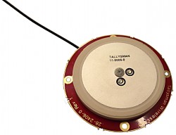
The Tallysman TW2926 antenna is an unhoused OEM version of the TW2920, designed for simultaneous reception of L-band correction signals and all of the upper band GNSS signals, including GPS L1, GLONASS G1, Galileo E1 and BeiDou B1. The TW2926 is 56 millimeters in diameter and has four drilled plated holes for secure mounting within customers’ products. It can be custom tuned to ensure optimal performance within an enclosure. The 1-dB bandwidth of both the TW2920 and TW2926 covers 1525–1559 MHz for the L-band downlink and 1559–1610 MHz for the upper-band GNSS. The LNA provides 28-dB of gain. The antennas employ Tallysman’s Accutenna technology, which provides strong cross-polarization rejection for greatly improved multipath rejection, low axial ratio and tight phase center variation.
The Near Field Communication (NFC) 88NF100 controller with active load modulation (ALM) is desgined to support the smallest antenna sizes critical to mobile, the Internet of Things (IoT), wearable and automotive applications. Adhering to NFC Controller Interface (NCI) Technical Specification version 1.1, the 88NF100 provides an extended operating range and is extremely energy efficient to enable extended battery life for power-critical applications. ALM technology supports the smallest antenna sizes to enable OEMs to implement NFC capabilities into small form-factor designs. The controller has extremely low power operation in polling mode to provide increased battery life for power critical applications and three single-wire protocol (SWP) interfaces to secure element (eSE) devices for secure payments. The two-pin antenna interface supports a maximum distance of two meters between the chip and antenna.
Designing Better Maps: A Guide for GIS Users, second edition, is an updated and comprehensive guide to creating maps that communicate effectively. Cartographer Cynthia A. Brewer covers the basics of good cartography, including layout design, scales, projections, color selection, font choices and symbol placement; she also describes her ColorBrewer application, an online color selection tool. The second edition includes a new chapter on map publishing. One reviewer wrote, “It is also worth a look by experienced cartographers who seek a refresher and a few new tips.” Brewer is a professor and chair of the Department of Geography at Pennsylvania State University and map and atlas design consultant.
Eos Pro Tools is tightly integrated with google map
Eos Pro Tools is a comprehensive RTK NTRIP app for Android that works with its Arrow line of RTK GNSS receivers. An Arrow GNSS receiver combined with the NTRIP app turns an Android smartphone or tablet into a powerful data collector capable of recording 1-centimeter accurate GIS data in real-time. The app, named Eos Tools Pro, has user-configurable audible and visual alarms to alert the user of high PDOP, lost RTK correction, unacceptable correction age and several other important metrics. It supports all current and future constellations (GPS, GLONASS, Galileo and Beidou). Detailed satellite information such as a skyplot that plots each visible satellite, whether it’s being used or not, and signal strength bar graphs from each constellation are also displayed. Finally, a terminal screen displays the NMEA data flowing and allows the user to send commands to the receiver.
Lightweight, ergonomic design for the mobile workforce
The 7-inch Algiz RT7 Android tablet is fully rugged, meeting stringent MIL-STD-810G U.S. military standards for protection against drops, vibrations and extreme temperatures. Its IP65 rating means that it’s waterproof as well as fully sealed against sand and dust. The tablet comes with a built-in accelerometer, gyroscope and e-compass as well as a stand-alone u-blox EA-7M GPS receiver for navigation, along with built-in Qualcomm IZat location services.
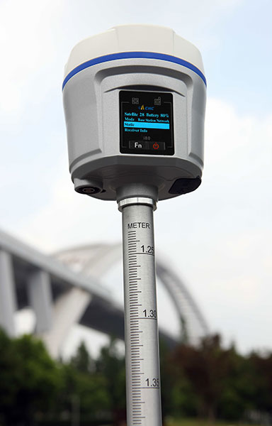
The i80 GNSS receiver computes a true triple-frequency real-time kinematic (RTK) tilted pole solution using all four worldwide and multiple regional constellations, providing a future-proof sub-centimeter RTK solution to surveyors and contractors. Without the need of a data collector or computer, the i80’s LCD graphic user interface allows for common workflow operations, such as static logging, autobase, autorover and UHF channel selection, to be easily performed. The CHC i80 incorporates dual hot-swappable batteries, allowing for days of uninterrupted work. While small and lightweight, it is packed with a full array of sensors and modules: multiple micro-electrical-mechanical (MEMS), internal Tx/Rx UHF, multiband cellular modem, Wi-Fi, Bluetooth, serial and USB.
All-in-one GPS, GNSS and RTK Data Collector Series
The SXPro series is built for mobile survey and GIS users for applications such as water, electric and gas utilities; transportation; mining; agriculture; and forestry. The professional-grade rugged handheld receivers include a battery life of more than 10 hours on a charge as well as a large outdoor-viewable touchscreen. The handhelds are rated IP65 for protection against water and dust, and equipped with a 5-megapixel autofocus camera and Microsoft utilities. The SXPro RTK (real-time kinematic) model offers 220 multi-constellation channels for centimeter accuracy with RTK networks. The SXPro GNSS offers 372 multi-constellation channels for sub-meter accuracy with SBAS corrections.
New point cloud analysis and visualization capabilities
The latest release of ENVI software adds lidar point cloud analysis and visualization capabilities that previously were only available in the ENVI lidar software package. ENVI 5.3 offers users a single software interface to work with hyper-spectral, multi-spectral, panchromatic and lidar data. The out-of-the-box functionality includes 3D point-cloud visualization, derived terrain product generation (such as digital elevation models) and lidar analytics such as viewshed line-of-sight calculation. For users who need point-cloud or terrain products in an area where collecting lidar is not feasible or is too expensive, the ENVI Photogrammetry Module is able to generate synthetic 3D point clouds from stereo optical imagery to take advantage of existing imagery archives. The dimension of time can be critical for a thorough geospatial analysis of an area, and the new ENVI release has added enhancements to the Spatio-Temporal analysis toolset. Spatio-Temporal analysis visualizes change and derives statistics from data over time, enabling users to observe past events to better predict upcoming activities.
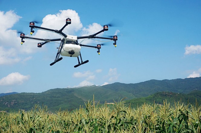
The eight-rotor DJI Agras MG-1 UAV can load more than 10 kilograms of liquid for crop-spraying and can cover between seven and 10 acres per hour — more than 40 times more efficient than manual spraying. It can fly up to eight meters per second and adjusts spraying intensity to flying speed to ensure even coverage. It is dustproof, water-resistant and made of anti-corrosive materials. It features DJI’s flight-control system and microwave radar to ensure centimeter-level accuracy. During flight, the drone scans the terrain below in real time, automatically maintaining its height and distance from plants to ensure application of an optimal amount of liquid. The drone’s intelligent-memory function means after the Agras MG-1 is brought back to base for refill or recharge, it will return to its last memory point to pick up spraying where it left off.
The EXCIPIO is an anti-drone system that uses a drone to shoot out a net to capture another drone.The EXCIPIO Aerial Netting System is comprised of a UAS equipped with a first-person view camera and a net-firing gun. When the EXCIPIO has reached the threat target, it fires a net, then can either release the net with the target ensnared or keep the net tethered. Though the initial system concept was focused on intercepting and neutralizing an airborne UAV, the conceptual applications have expanded to include manned aircraft, ground vehicles, people and animals (whether airborne or on the ground).
Topcon Positioning Group has released a new excavator system with local positioning system (LPS) capabilities. The X-53i LPS is designed to provide a solution for machine-controlled excavation in sky-obstructed areas.
“The system is perfect for projects such as tunnel construction or working within existing structures using a total station and prism for precision,” said Kris Mass, director of construction product management. “It’s also versatile when GNSS positioning is available with the new Topcon MC-i4 receiver. Operators can easily choose which type of sensor to best use for the project.”
The system is compatible with the new Topcon GX-55 control box — a large sunlight-viewable LCD touchscreen with integrated LED light bars designed for continuous grade reference of the bucket’s teeth. “It’s the finest graphical experience for modern machine control with customizable audible tones, all wrapped up in a lightweight package for easy transfer and storage,” Maas said.
Topcon Positioning Group has released the latest addition to its line of compact digital laser sensors — the LS-100D. The sensor digitally displays the offset value to on-grade, which is designed to help make elevation and vertical alignment control easier and faster for any application.
“The LS-100D features an extra-wide beam capture sensor that also rejects annoying interference from strobe-light exposures,” said Kris Maas, director of construction product management. “The large and bright LCD displays (front and back) feature nine channels of grade information and digitally display the distance to on-grade. By pressing the hold button, the display is locked so the user can conveniently read the results.”
The sensor offers three colored LED’s and a magnet mount for vertical operation, which is designed to be useful for steel erection or operator grade-checking while excavating. Alert icons appear on the LCD if the accompanying Topcon rotating laser instrument is disturbed (HI alert) or when the laser battery is low.
UAV company DJI is offering its first tuned propulsion system designed for all-weather use in industrial applications and filmmaking.
The E2000 propulsion system has the power to handle add-ons such as computing devices and advanced imaging equipment. It uses a combination of 6010 motors, 1240S/X field-oriented control (FOC) electronic speed control (ESCs), and 2170 propellers to carry payloads of 1800–2500 grams (g) per axis, with a maximum thrust of up to 5100 g/rotor (50V, sea level).
The 6010 motor’s bearings are fully sealed to prevent flu
ids such as salt water from causing corrosion. A special surface coating applied to the stator also greatly improves its ability to withstand rusting.
To more effectively dissipate heat generated under intensive industrial use, the 6010 motor features an integrated centrifugal cooling system that effectively cools the motor while keeping dust and micro particles out. The 1240S FOC ESC is equipped with a silica thermal pad and heat sink for maximum heat transfer and dissipation.
The E2000 is available in Standard and Pro versions to meet the demands of professional and industry users. Both the 6010 Standard and Pro motor bearings are fully sealed to prevent fluids like rain, pesticide, and salt spray from entering and causing corrosion. A special surface coating applied to the stator also greatly improves its ability to withstand rusting.
The same effective weather sealing has also been applied to the external 1240S ESC found with the E2000 Standard. The E2000 Standard has an IP56 rating.
Topcon Positioning Group has released the latest addition to its ES total station series, the ES-50. Featuring advanced reflectorless capabilities, the new ES-50 is designed to provide an entry-level total station option with a fast and powerful electronic distance meter (EDM).
“With the functionality of many high-end robotic total stations, our ES series is known to be full-featured and ready to tackle modern job sites,” said Ray Kerwin, director of global surveying products. “The ES-50 incorporates all those time-honored expectations, along with a reflectorless EDM of up to 350 meters, and 4,000 meters with the use of a prism.”
The ES-50 offers 2- and 5-arc second accuracies for distance measurements in projects such as land surveying, topography and as-built, construction and layout, or foundation and exterior job sites.
Additional features include a battery life of up to 15 hours, dual-axis compensation, a waterproof design and a laser pointer.
By measuring and signaling tilt from a level position, the inclinometer helps to ensure precise execution in applications such as semiconductor manufacturing, satellite dish alignment, robotic controls, aerial lift platform leveling and wheel alignment systems. It is designed for measuring position in industrial applications to ensure accurate performance and consistent production.
The inclinometer uses RS-485 communications, which allows up to 32 sensors on a single network to reduce wiring requirements. Additional benefits include low power consumption, small size, long life and excellent resolution and repeatability. It has a supply voltage of 5 V DC, ±10˚ dual axis range and operating temperature of -40 °C to +70 °C.
“The Dual Axis RS-485 Inclinometer provides reliable tilt measurement for a wide range of applications where high precision leveling is critical,” said Heidi McKenna, president of The Fredericks Company.
UK aerial mapping company Bluesky has reduced the time taken to process the terabytes of data captured by more than 75 percent, which will speed the production of aerial photography.
Following a major research project, the team at Bluesky’s Leicestershire production facility has implemented an UltraMap system from Microsoft, which has allowed for the introduction of a continuous, uninterrupted processing workflow. By investing in an entirely new workflow, Bluesky has also improved the quality of the aerial images, reducing “building lean” and image distortion, and the accuracy of its digital height models.
Bluesky’s investment in software follows the recent purchase of two UltraCam Eagle cameras, also from Microsoft, and the introduction of new flying practices.
Bluesky has recently secured a number of high-profile contracts, including a multimillion pound contract for the supply of geographic data to Central Government organizations awarded by the Department for Environment, Food and Rural Affairs (DEFRA), and a four-year contract to supply the national mapping agency for Great Britain, Ordnance Survey.
Earlier this year, Bluesky announced plans and commenced data capture for the first high-resolution aerial survey of the whole of the Republic of Ireland, and will also create digital surface models and terrain models.
“2015 has been a phenomenal year in terms of data volumes to be processed,” said Bluesky’s Technical Director James Eddy. “We have introduced new flying methods, we have secured a number of large contracts and we are actively pursuing our own ambitious flying program. This has meant the volume of raw data to be processed is unprecedented.”
Microsoft UltraMap is an end-to-end photogrammetric workflow system that provides highly automated processing capabilities, allowing Bluesky to rapidly generate quality data products from UltraCam cameras. The improved workflow is designed to process huge amounts of data in the shortest possible time with the highest degree of automation, supported by guided manual interaction, quality control tools and powerful visualization.
“In order to process the many terabytes of data produced in a flying season — for example, we are looking at over a trillion DSM (digital surface model) points alone — the UltraMap system is just one component of a complex system,” continued Eddy. “We have also invested significantly in hardware, including an array of multi core processors, our network infrastructure, a robust backup system, internally produced software to increase and improve QA and improve productivity, and of course, perhaps most importantly, skilled and experienced staff.
“We now believe we operate one of the most advanced aerial imaging processing facilities in the UK, if not the world and we have the capacity to handle our largest-ever projects.”
Antenova Ltd., manufacturer of antennas and RF antenna modules for machine-to-machine (M2M) and the Internet of Things, is adding two new positioning antennas to its range of flexible FPC antennas.
Bentoni is a positioning antenna for all of the global public satellite constellations: GPS, GLONASS, BeiDou and Galileo. It is designed to be used in trackers, portable devices, network components, drones and wearable electronics.
Asper is a dual antenna with two separate antenna systems in a single form factor. It combines a 1559–1609 MHz antenna with a 2.4–2.5 GHz antenna in the same part for positioning applications with wireless connectivity as well. This antenna is suitable for sports cameras, trackers, dash cams, portable devices, network devices and wearable electronics.
Both antennas offer high performance and maintain good isolation in situ within a device.
Bentoni and Asper are the latest flexible FPC antennas in Antenova’s flexiiANT product range. They are supplied with an I-PEX MHF connector and a 1.13 mm RF cable in a choice of three lengths. They can be folded to save space in operation within a device.
Antenova’s antenna design team aims to create antennas that a product designer can integrate with the other circuits in a design in a convenient way, rather than designing a product to fit around the antenna. The aim of these antenna designs is plug and play simplicity — they are self-adhesive mounted so that they can easily be fixed inside an electronic device.
Bentoni antenna and Asper antennas are available to order now.
Windows 10 and a new large display are key features of Juniper Systems’ latest tablet, Mesa 2 Rugged Tablet, released today.
Juniper Systems is a provider of ultra-rugged field data collection solutions.
Featuring the largest display produced by Juniper Systems to date, the Mesa 2 is also Juniper Systems’ first handheld to run on the new Windows 10, which the company said allows for improved decision-making in the field, as well as smooth transitioning from field data collection to office work and back.
With a full Windows 10 operating system, the Mesa 2 provides users with access to a broader range of software options to meet their data collection needs and is powerful enough to use in place of a desktop computer when in the office. The Mesa 2’s 7-inch display strikes a perfect balance between providing ample viewing area for collected data and reducing overall weight for minimal fatigue and superior, all-day comfort, the company said.
The Mesa 2 is designed to perform reliably in harsh environments, and is the only IP68-rated rugged Windows tablet available, providing complete protection against water and dust. It maintains a seal while its ports are in use, while most other tablets on the market are exposed to damage from water and dust if the port cover is not securely in place.
The Mesa 2 also features an extraordinary IllumiView display, providing best-in-class visibility in any lighting conditions, and its chemically-strengthened Dragontrail glass touch screen provides superior durability, reducing haze from surface scratches and cracks normally caused by accidental impact.
The Mesa 2 battery provides users with a full 8-10 hours of runtime, allowing for maximum productivity throughout the workday. Users may also purchase an optional expansion battery from Juniper Systems that provides an additional 4-5 hours of runtime plus hot swap capabilities for those extra-long days where overtime is required.
“The Mesa 2 is in a new sphere relative to our other ultra-rugged devices,” said Nate Holman, Director of Sales and Marketing at Juniper Systems. “While it features the same degree of outstanding quality and ruggedness as other Juniper products, the Mesa 2 provides users with more software options and greater processing capabilities, due to its full Windows 10 operating system and Intel quad-core processor. The Mesa 2 is designed to improve productivity along every point of the data collection process, from the initial planning and gathering of data, to the later data analysis, and finally through the decision-making process. It’s a tablet optimized for efficiency, designed to be ‘your office, anywhere’.”
The Mesa 2 Rugged Tablet will begin shipping in the first quarter of 2016.