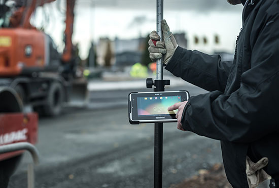
Handheld Group’s new Algiz RT7 tablet is designed for rugged use by mobile workers.
Handheld Group, a manufacturer of rugged mobile computers, today announced the launch of its new Android tablet, the Algiz RT7. The Algiz RT7 is a powerful, lightweight and ergonomic 7-inch tablet designed for reliable performance in demanding environments.
The Algiz RT7, which runs Android 5.1.1 (Lollipop), provides a range of features for mobile workforces, Handheld said. It’s fully rugged, meeting stringent MIL-STD-810G U.S. military standards for protection against drops, vibrations and extreme temperatures, and its IP65 rating means that it’s waterproof as well as fully sealed against sand and dust. Weighing just 650 grams, the Algiz RT7 is designed for mobility.
The Algiz RT7 comes with a built-in accelerometer, gyroscope and e-compass and a stand-alone u-blox EA-7M GPS receiver for navigation, along with built-in Qualcomm IZat location services.
A Qualcomm MSM8916 (Snapdragon) chipset and 1.2 GHz quad-core processor power the tablet, giving it processing speed, ultra-fast connectivity and long battery life. It comes standard with LTE data and voice capabilities as well as 802.11 b/g/n WLAN, BT Class 1 and Class 2, and NFC functionality. It also has dual cameras (8-megapixel rear-facing and 2-megapixel front-facing), as well as dual SIM-card slots.
Designed for the mobile worker, the Algiz RT7 sports a high-brightness 7-inch outdoor-viewable capacitive display that can handle true outdoor challenges. Battery performance is key for any mobile application, and the Algiz RT7 comes with a long-life 3.7V 6000mAh lithium-ion battery. Four programmable buttons allow users to launch and use applications in the field. To enhance data capture, users can choose an optional 2D imager or RFID plus 2D imager.
“Our new Algiz RT7 offers enterprises an exceptional value and is a highly requested product from both our end users and our extensive partner network,” said Jerker Hellström, Handheld Group CEO. “This ultra-rugged tablet delivers best-in-class performance to assist fieldworkers in their daily tasks. The Algiz RT7 is built for tough environments and delivers a streamlined Android experience with power and features appropriate for market demands.”
The Algiz RT7 can be ordered immediately. Shipping will start in December, with volume deliveries starting January 2016.
The Bullray UAS is a fully autonomous, amphibious, man-portable tricopter/quadcopter that makes vertical take-offs and landings.
Rated IP-67, the rugged design is capable of performing in all weather conditions and doesn’t require a transit case. It can carry a significant sensor payload: GPS, FLIR cameras, lidar, metal detection systems and more.
Rapid Composites — builder of high-end UAVs for the military and first responders — custom manufactures the units. The company won the UAV category in the 2015 JEC Innovation Awards.
Carlson Mining 2016 has improvements and added support for AutoCAD 2016 and the new IntelliCAD 8.1. The improvements span the four mining modules: Basic Mining, Geology, Surface Mining, and Underground Mining.
An upgrade to the Haul Truck Cycle Analysis command now accounts for mixed fleets, delay points and 3D playback of trucks along the haul route.
In the Underground Mining module, support has been added for multi-level mining with the addition of level labels, allowing the processing of overlapping mine panels with ease.
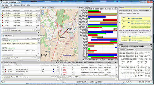
Carlson SurveyGNSS, Carlson Software’s data post-processing software, is now available in a 2016 version.
Designed for surveyors and positioning professionals, Carlson SurveyGNSS post-processing software achieves high-accuracy results for computing quality vectors and resultant positions. SurveyGNSS works with Carlson SurvCE and SurvPC data collection software, and with Carlson’s office design software.
New features include a second-generation post-processing engine, which now accepts data in enhanced RINEX 3.x formats. Users will also determine candidate vectors for simultaneous calculation. Previously, vectors were calculated individually.
Other processes have been sped up or enhanced. With “detached processing,” users will be able to start another task while SurveyGNSS is still working on a computation.
New constellation and more reference networks are another enhancement. Observations from the Chinese BeiDou and European Union Galileo join GPS and GLONASS, with future constellations in the works.
For supported “Active” (Online) Reference Networks, the International GNSS Service (IGS) and the governments of Australia, Brazil, Canada, Germany, Spain, European Union, France, Great Britain, Mexico and the Netherlands join the supported networks in addition to the U.S. CORS system.
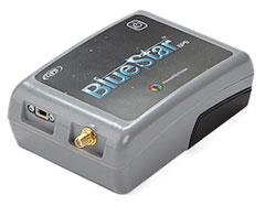
BlueStarGPS offers both GPS and GNSS options in a rugged, lightweight package. The BlueStarGPS device was designed to meet sub-meter mapping and data collection needs in the pipeline and utility industries. It provides sub-meter precision without post-processing, and maintains accurate positioning when the SBAS signal is obstructed. This means it can function under trees, around buildings and in rugged terrain where other receivers can fail.
The BlueStarGPS is designed specifically for use with Android mobile devices, such as smartphones, tablets or notebook computers, as well as cable and pipe “locating” tools with a connectivity range of up to 1 kilometer.
The X20i GNSS receiver by CHC Navigation pairs with iOS devices.
The X20i L1 GPS receiver by CHC Navigation is powered by a high-precision L1 GPS engine. Its integrated Bluetooth chip enables it to wirelessly collect submeter positions in real time or centimeter post-processed on an iPhone or iPad.
All location-aware apps on the iPhone and iPad are compatible with the X20i. Immediately after pairing and answering the security question allowing the X20i to take control of location services on the iOS device, 1 million iOS applications are capable of utilizing the high-accuracy data of the X20i, and become accurate to either 1 foot or 1 centimeter. Apps that can make use of the high accuracy include TerraGo Edge, ESRI’s ArcView Connector, and those by CarteGraph Systems.
Chip simplifies integration of GNSS into low-cost products
The Broadcom BCM47748 chip for the Internet of Things and wearables enables devices such as fitness bands to deliver pinpoint location while consuming minimal power and in some cases can eliminate the need for a separate microcontroller. The BCM47748 removes a bulk of the signal processing from the device MCU by calculating position, velocity and time on-chip, delivering significant system power savings. The chip uses intelligent firmware to extend battery life while maintaining accuracy in speed, distance and position. By absorbing location computations on-chip, Broadcom not only reduces power consumption but can also dramatically lower costs for OEMs by replacing the device MCU and reducing board space. Firmware inside the BCM47748 automatically adapts to user activity and context, whether biking, walking or running, to provide precise location results to the user, enabling performance that is not sacrificed for power savings.
Simulation through real-time generation of GNSS signals
The upgraded ReGen DIF simulator is a high-end, low-cost 24-channel GNSS multi-frequency RF simulation solution for academia and research and development. The Replicator provides users with GNSS simulation through real-time generation of GNSS signals; the recording and playback of dual-frequency GNSS RF signals; and GNSS RF signal analysis with the JAXA COSMODE ionospheric scintillation monitor. Features of the replicator support various combinations of GPS L1, L2; GLONASS L1,L2,L3; BeiDou B1, B2; and Galileo E1 signals, and include ANSI C API for user access to customizable signal propagation, orbital, multipath, spatially correlated, scintillation and other error models.
Designed for unmanned aerial systems and mobile platforms
The S2525F8-BD-RTK is a low-power, single-frequency RTK receiver with centimeter-level position accuracy. It supports GPS, BDS, QZSS and SBAS, simultaneously tracking up to 28 satellites. With its 25 x 25 millimeter form factor, 300-mW power consumption and 3 gram weight, it is designed for any outdoor applications requiring high-precision RTK positioning. S2525F8-BD-RTK supports both base station and rover modes. As a rover, it receives RTCM 3.0 or 3.1 data from a base station, or raw measurements from another S2525F8-BD-RTK receiver serving as base station, and performs carrier phase RTK processing to achieve relative positioning with 1 cm + 1 ppm position accuracy within 10-Km baseline.
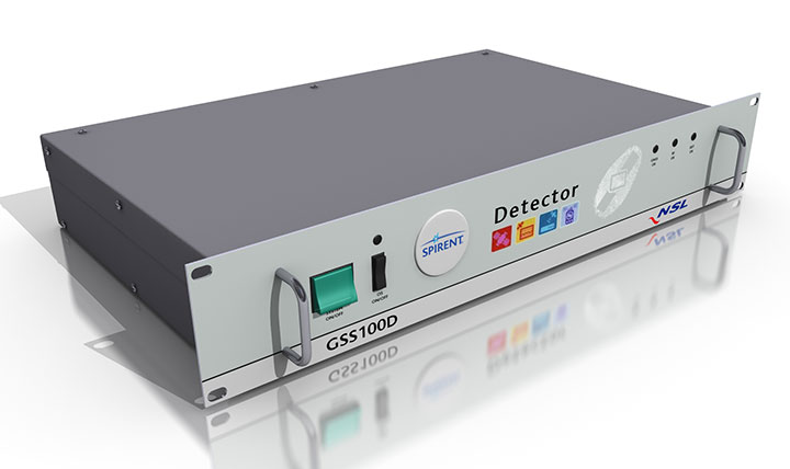
Spirent robust framework evaluates threats to GNSS
The GSS100D Detector is key to a robust PNT test framework to evaluate GPS and GNSS security vulnerabilities for position, navigation and timing systems. The framework will be used by technology, system and application developers where PNT is critical. The framework enables threats to be detected in the field, taken into the lab, and re-synthesized along with GPS and other GNSS signals. Spirent’s threat intelligence library of actual and typical threats provides a wide range of GNSS segment errors and spoofing attacks, as well as space weather and other vulnerabilities for preventive troubleshooting. Developed in collaboration with Nottingham Scientific Ltd., the GSS100D Detector enables detection, characterization and analysis of real GNSS threats.
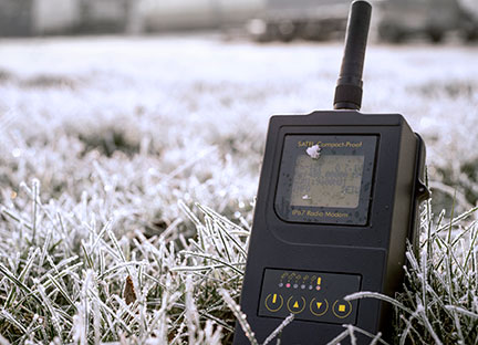
Priate radio data system for measurement applications
Compact-Proof is a UHF radio modem for wireless data transfer with a rechargeable battery, providing a compact and flexible solution for a wide range of applications, including land surveying under varying weather conditions. It supports the radio protocols of Pacific Crest, Trimble and other GNSS providers. It has a temperature range of -30°C to +65°C and frequency ranges of 330 MHz…420 MHz and 403 MHz…473 MHz. Its casing and connectors are rated IP67, making it waterproof and secured against dust. With transmitting power of 1,000 mW, it can be operated fully autonomously for more than 15 hours as a repeater station in the field.
Base station or rover survey receiver with 864 channels
The all-in-one TRIUMPH-LS combines a high-performance 864-channel GNSS receiver, all-frequency GNSS antenna, and a modern featured handheld. The 864 all-in-view channels include Galileo E1/E5A/E5B, GPS L1/L2/L5, GLONASS L1/L2/L3, QZSS L1/L2/L5, BeiDou B1/B2 and SBAS L1/L5. The TRIUMPH-LS offers GUIDE data collection, Visual Stake Out (VSO), navigation, six parallel RTK engines, more than 3,000 coordinate conversions, advanced CoGo features, and rich attribute tagging on a high-resolution, bright, 800 x 460 bright display. Two 3-megapixel cameras enable recording of images along with GNSS data.More than 100 channels are dedicated to continuous interference monitoring. The Triumph-LS monitors and reports interference graphically and numerically with patent-pending interference protection. Interference awareness allows safe GNSS operation in city, airport and military environments. The unit can serve as base or rover. It has a GSM modem, UHF transmit and receive, and an internal high-performance geodetic antenna. The TRIUMPH-LS automatically updates all firmware when connected to a Wi-Fi Internet connection.
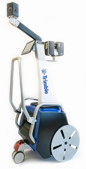
The Trimble Indoor Mobile Mapping Solution (TIMMS) produces fast and accurate maps of difficult-to-navigate indoor spaces and translates them directly into 2D and 3D models of structured interiors. TIMMS 2 is a fusion of technologies for capturing spatial data of indoor and other GNSS denied areas, providing both lidar and spherical video and enabling the creation of accurate, real-life representations of interior spaces and all of their contents. The maps are geo-located; the real world positions of each area of the building and its contents are known and can be easily placed and oriented in a wide area model. Small and lightweight, TIMMS 2 can negotiate tight corners, closets and catwalks, and can be carried up and down staircases where no elevator is available for travel between building levels.
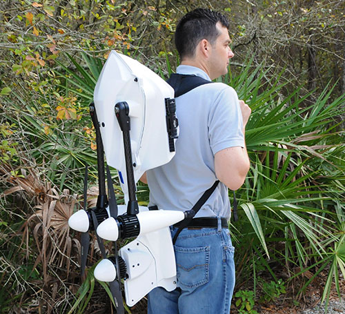
The new Leica Geosystems Pegasus backpack wearable mobile mapping solution.
Wearable reality capture
Portable backpack allows mapping while walking
The Leica Pegasus:Backpack is a wearable reality-capture technology that combines five high-dynamic cameras and two LiDAR profilers within an ultra-light and ergonomic carbon-fiber chassis. The ergonomic mobile mapper creates a 3D view indoors or outdoors for engineering or professional documentation while using SLAM (simultaneous localization and mapping) to determine position in GNSS-denied areas. With its fast and efficient capture, calibrated images and point clouds are quickly generated for applications as diverse as BIM 6D to industrial training and disaster analysis.
The YellowScan is a lightweight lidar designed for fixed or rotary-wing UAVs. It has an embedded Ellipse-E, a miniature inertial navigation system from SBG Systems, which helps obtaining a clear and accurate point cloud. YellowScan is operational at up to 75 meters and delivers a highly dense point cloud. It includes a lidar with a ±50 degree angle that measures 40,000 points per second, an Ellipse-E inertial navigation system coupled with a centimeter-level RTK GPS, an on-board computer and an integrated battery. LED lights provide useful information, such as whether the GPS is receiving RTK corrections.
The DJI GO app is an upgrade to the previous DJI Pilot app with a redesigned user interface to make it easier to capture and share images with DJI’s Phantom 3, Inspire 1 and Matrice 100 UAVs. The app includes expanded in-app editing tools to make it easier to adjust photos and videos before uploading to social networks. DJI Director, which automatically edits the best moments from flights into short videos, has also been upgraded to include video speed control, additional templates and background music options.
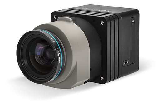
Lightweight with the resolution of a medium format system
The iXU-R camera series for UAVs is available in 80 MP, 60 MP and 60 MP achromatic versions. The cameras feature dedicated interchangeable 40-mm, 50-mm and 70-mm Phase One Rodenstock lenses equipped with central leaf shutters that can be quickly changed in the field, offering flexibility in aerial applications. The Phase One iXU-R systems have been designed to address the aerial data acquisition market’s needs with high-performance optics, flexibility to fit into small places and Phase One’s fastest 80 MP platform. Phase One aerial cameras offer direct communication with GPS/IMU systems and the ability to write data to the image files.
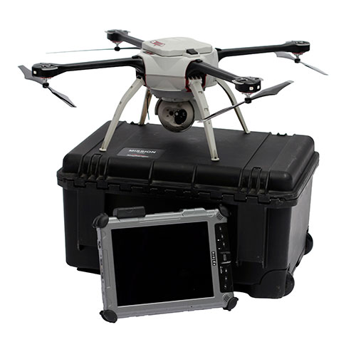
The Aeryon SkyRanger introduces a new airframe and integrated system design to its Aeryon sUAS (small UAS) platform, based on thousands of hours of flight time and successful customer exercises and missions around the world. The SkyRanger is suited for both land and maritime applications, and is designed to military and government specifications for immediate aerial intelligence gathering. Vertical Take-Off and Landing (VTOL) enables continuous eyes-on-target, operations in confined or hard-to-reach environments, and low-risk launch and retrieval without peripheral equipment. Features include up to 50-minute flight time, single operator transport and deployment with no launch or recovery equipment, reliable flight performance in demanding environments such as high winds, and an intuitive touchscreen interface. Microsoft has chosen the SkyRanger to demonstrate aerial image and data capture for its new Microsoft Advanced Patrol Platform (MAPP) vehicle.
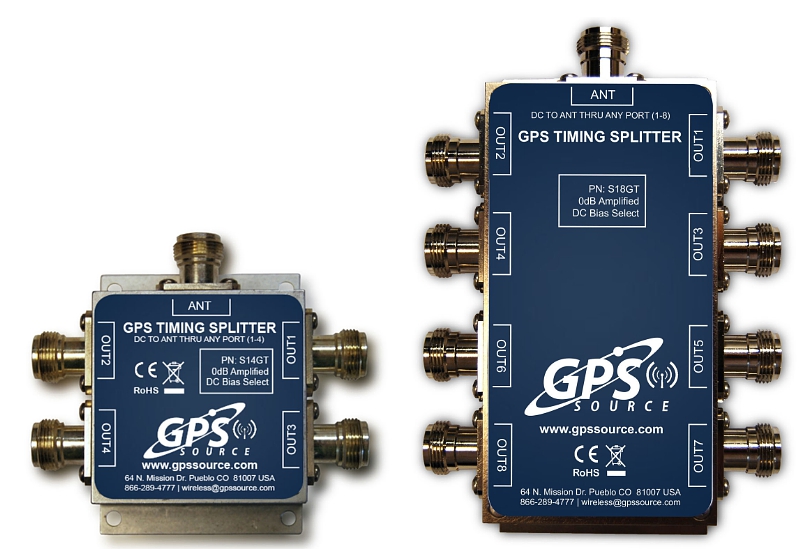
GPS Soure is offering the S14GT & S18GT splitters for small cell networks and distributed antenna systems (PRNewsFoto/GPS Source, Inc.)
GPS Source has released of a line of GPS/GNSS splitters created for the small-cell wireless and distributed antenna system markets. Specifically designed for the L-band frequency, they can eliminate the cost of multiple antennas and long cable runs in wireless installations.
With four or eight outputs, the new line of GPS/GNSS splitters make it possible to use a single GPS referencing antenna and cable arrangement for multiple synchronized systems. The splitters are available at a low price point and include features such as DC bias select and amplification.
GPS Source RF signal splitters typically operate in conjunction with an active GPS antenna (a GPS antenna that includes an integrated low noise amplifier). Consequently, a GPS RF signal splitter must have provisions for managing the DC voltage to the active GPS antenna. The S14GT and S18GT will power an external GPS antenna from any of the RF outputs. A “hunt-and-pick” circuit is used to select only one DC input for power should more than one source be connected. Designed for redundancy, if the selected DC bias input should fail, the DC bias will automatically switch to another DC input to ensure an uninterrupted power supply to the active antenna.
“Distributed antenna systems allow for easy system growth in size and scope of application, whether the system needs to scale to reach new service areas or add bandwidth and capacity,” said Robert Horton of GPS Source. ” This growth has led to a strong demand for cost effective solutions that support GPS synchronization, an area where we are specialists. GPS Source brings leading-edge technologies and addresses major GPS/GNSS challenges faced by carriers and system integrators.”
The S14GT and S18GT are in production and will be available January 2016. A CE Mark approval from the European Notified Body for these two devices will be available afterward.
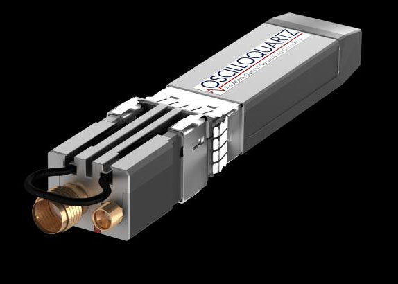
Oscilloquartz, an ADVA Optical Networking company, has launched its OSA 5401 Syncplug, an accurate and efficient small-form-factor pluggable grandmaster clock and GNSS receiver.
The device has a small footprint and compact design. It complements the existing portfolio of Oscilloquartz products, driving precise IEEE 1588v2 Precision Time Protocol (PTP) frequency and phase synchronization as well as Synchronous Ethernet deeper into access networks, including radio access and small cell networks.
With its miniature form factor and low-touch provisioning, the new synchronization solution can be deployed in space-restrictive environments. It operates at low cost, consumes minimal energy and requires no additional power source or real estate, Oscilloquartz said.
The OSA 5401 Syncplug supports the creation of a new time distribution architecture to meet the stringent phase-synchronization requirements of today’s access networks, the company said.
“In terms of efficiency, precision and density of design, our OSA 5401 Syncplug miniature grandmaster is a major development for our industry,” said Kenneth Hann, senior director, R&D, Oscilloquartz. “It’s possibly the world’s smallest grandmaster clock and yet it generates phenomenally precise PTP frequency and phase synchronization for radio access and small cell networks. Now network operators have a cost-effective migration path for deploying robust phase and frequency synchronization deeper into access networks. Our OSA 5401 Syncplug integrates with existing network elements and its small form factor and rich feature set enable a versatile range of deployment options for enhanced synchronization network performance. Its timing-optimized, dual-frequency GNSS receiver achieves excellent performance even in urban canyons where small-cell deployments are often made and it can also work with a single satellite.”
The OSA 5401 Syncplug is the first new product to be jointly engineered by Oscilloquartz and members of the recently acquired Time4 Systems. It easily conforms to all relevant PTP telecom profiles and, when locked to global navigation systems, meets the stringent requirements of G.8272 and G.811 specifications. The device functions as a Synchronous Ethernet source, GNSS receiver and a grandmaster clock. It can support both Layer 2 and Layer 3 PTP transport and is capable of unicasting and multicasting simultaneously. Advanced design and network redundancy techniques provide resiliency against local GNSS jamming. It also boasts an impressively wide operational temperature range of -40 to 85 Celsius. But the key benefits that the OSA 5401 Syncplug provides are space and energy efficiency for significant savings in installation and engineering costs. It also fully complies with multi-source agreements for total interoperability.
“An enormous amount of expertise and passion has gone into designing this device. It’s been driven by our strategic understanding of what’s most needed in the synchronization space,” said Gil Biran, general manager, Oscilloquartz.
“This first member of our miniature sync product family has already won great feedback from major mobile operators. What makes our ultra-compact OSA 5401 Syncplug so special is that it combines small size with high performance,” Biran said. “Make no mistake, there’s a vast amount of advanced functionality squeezed into this device. That’s what enables it to deliver highly accurate timing distribution with the smallest available footprint. This level of agility and efficiency creates a new range of solutions for service providers to deploy phase synchronization even in the most difficult network scenarios. There’s no doubt that this is an exciting time for network synchronization technology and this new product will extend our position in the market as a one-stop shop for all synchronization solutions. The new generation of mobile networks demands more small cells and a higher density of radio heads and we’re addressing this challenge in the most energy-efficient and cost-effective way possible.”
Watch ADVA Optical Networking’s latest video on assisted partial timing support for more information.
Bentley Systems’ latest infrastructure products are now available. They include SewerGEMS, SewerCAD, StormCAD and CivilStorm V8i (SELECTseries 5) products for the analysis and design of wastewater and stormwater systems. All of the V8i (SELECTseries 5) sewer and stormwater products can be used as stand-alone products, or be run on CAD and GIS platforms.
They can also now be used from within the V8i (SELECTseries 4) versions of OpenRoads-based products — combining 3D design and hydraulic analysis capabilities in the same platform. The resulting comprehensive civil solution eliminates the need for extra import/export steps or file conversions, Bentley Systems said.
“The integration of Bentley’s OpenRoads civil design functionality with the advanced capabilities of Bentley’s storm and sewer analysis products will be a huge benefit to productivity and quality for our highway drainage design workflows,” said Chris Haines, senior civil engineer and PAR-BIM technical lead, Drainage and Utilities, Parsons.
Terrain model elevations on profiles.
“With these new releases, the automated hydraulic design functionality of our sewer and storm products can be effortlessly combined with the 3D physical design and terrain modeling capabilities of Bentley’s other civil products,” said Gregg Herrin, Bentley Systems director of product management, hydraulics and hydrology. “From an information mobility standpoint, this has a direct and substantial positive impact on roadway, site and municipal work where hydraulic engineering is just one part of a much larger project.”
Bentley’s SewerGEMS, SewerCAD, StormCAD and CivilStorm V8i (SELECTseries 5) products provide the following capabilities:
Ground elevations from terrain models may be used during automated design runs to consider “cover” along a pipe’s length, improving decision making related to system design.
Terrain model elevations can also now be added to profiles, improving the resulting visualization and the user’s understanding of the physical network.
New low-impact development (LID) elements are now available, making it easier to model a wider range of controls for stormwater management.
With the new lateral link element, engineers can include lateral pipes in their hydraulic analysis without creating “fake” elements where the laterals connect to the main pipe.
Easy access to the Bentley Communities professional networking site is embedded within the applications, facilitating communications between users and Bentley’s hydraulic modeling experts.
Users of any of these SELECTseries 5 releases now benefit from the products’ support of MicroStation V8i (SELECTseries 3), OpenRoads V8i (SELECTseries 4), AutoCAD 2015 and 2016, and ArcGIS 10.2 and 10.3 (SewerGEMS only), giving them the ability to model from within the latest MicroStation, OpenRoads, AutoCAD or ArcGIS version.
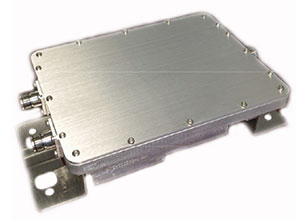
The new PXC021-V2 by Filtronic is a wideband cellular + GPS low-loss splitter/combiner.
Designed for repeater/DAS applications, the PXC021-V2 provides GPS L1 and L2 frequency coverage and wideband cellular frequency coverage (618-960 MHz and 1695-2690 MHz). It has low loss (≤ 0.30 dB Cellular and ≤ 0.70 dB GPS) and excellent cellular to GPS isolation (≥ 55 dB).
The L1/L2 Channel Absolute Group Delay is 20 nS maximum (17 nS typical), and the variation is 4 nS p-p maximum over the L1/L2 bandwidth. The
CEO Johannes Riegl unveils the new RIEGL BathyCopter at the Riegl INTERGEO booth in Stuttgart.
Following RIEGL‘s debut of the RiCOPTER at INTERGEO 2014, a fully integrated UAV-based lidar surveying solution, the company used INTERGEO 2015 in September to launch its new BathyCopter.
The BathyCopter is a small-UAV-based surveying system capable of measuring through the water surface. It’s suitable for generating profiles of rivers or water reservoirs. The platform design integrates a topo-bathymetric green laser depth-meter, an IMU/GNSS unit with antenna, a control unit and a digital camera. Applications include generation of river profiles, survey of reservoirs and canals, landscaping, support of construction projects, and surveys for planning and carrying out hydraulic engineering work.
Laser Scanner. RIEGL also offers the VQ-480-U laser scanner for UAVs, which provides high-speed data acquisition using a narrow infrared laser beam and a fast line scanning mechanism.
High-accuracy laser ranging is based on RIEGL’s echo digitization and online waveform processing, which provides measurement results even under adverse atmospheric conditions, the company said.