The latest release of ENVI software, version 5.3, adds significant lidar point cloud analysis and visualization capabilities that previously were only available in the ENVI lidar software package. The Harris Corporation software offers users a single software interface to work with hyper-spectral, multi-spectral, panchromatic and lidar data.
The out-of-the-box functionality includes 3D point-cloud visualization, derived terrain product generation (such as digital elevation models) and lidar analytics such as viewshed line-of-sight calculation.
For users who need point-cloud or terrain products in an area where collecting lidar is not feasible or is too expensive, the ENVI Photogrammetry Module is able to generate synthetic 3D point clouds from stereo optical imagery to take advantage of existing imagery archives.
The dimension of time can be critical for a thorough geospatial analysis of an area, and the new ENVI release has added enhancements to the Spatio-Temporal analysis toolset. Spatio-Temporal analysis visualizes change and derives statistics from data over time, enabling users to observe events of the past to better predict upcoming activities.
New additions were also added to the ENVITask system, a relatively new method for performing discrete bits of image processing programmatically through the ENVI object-based API. This programmatic approach to image processing can save time because users can chain together multiple ENVITasks, allowing the output from one ENVITask to become the input to the next. There are now 138 ENVITasks available in the ENVI API.
MicroSurvey Software has released MicroSurvey CAD 2016, the newest generation of its desktop survey and design program for land surveyors and civil engineers. Powered by a new IntelliCAD 8.1a engine and enhanced with a suite of new point-cloud management tools, the software makes high-impact drafting and design fast and intuitive, the company said.
Users on multi-core computers will experience up to 300 percent faster performance compared to previous versions, which substantially improves productivity. Navigation has been enhanced through a new ribbon interface with high-resolution icons that provide easy access to frequently used tools. The newest version of the software is also able to open and export DGN files, handle annotation scaling, and publish drawings as DWF/DWFX, PNG and JPG files.
Point Clouds. The new release includes significant enhancements for working with point clouds. The Ultimate and Studio versions of the software are now powered by the same point-cloud engine that drives Leica Cyclone and CloudWorx software, making it possible to directly import Leica Cyclone and Leica JetStream databases using Cyclone dialogs.
Users can view panoramic photographs captured by the laser scanner and snap to points directly from the photographs in a TruSpace window. Point-cloud data is now displayed directly within the CAD model space.
MicroSurvey CAD is compatible with field data from all major total stations and data collectors and is fully compatible with AutoCAD; 64-bit and 32-bit versions are available.
Geneq has introduced a new “all-in-one” GPS, GNSS and RTK Data Collector Series, the SXPro.
The professional-grade series of handheld receivers is accurate, rugged and competitively priced, the company said.
Standard features include an extra-long battery life of more than 10 hours on a charge as well as a large outdoor-viewable touchscreen. The handhelds are rated IP65 for protection against water and dust.
The SXPro handheld is also equipped with a 5-megapixel autofocus camera and Microsoft utilities. The SXPro is sold as a fully loaded package that includes a spare battery, hard carrying case and Field Genius Survey Data Collection software.
The SXPro series is built for mobile survey and GIS users for applications such as water, electric and gas utilities; transportation; mining; agriculture; and forestry.
The SXPro RTK (real-time kinematic) model offers 220 multi-constellation channels for centimeter accuracy with RTK networks. A surveyor-grade external dual-frequency antenna and cables are included.
The SXPro GNSS offers 372 multi-constellation channels for sub-meter accuracy with SBAS corrections.
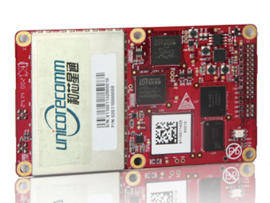
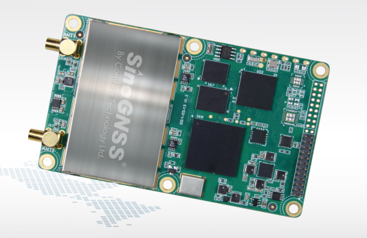
The UB380 GPS/GLN/BDS tri-constellation octa-frequency high-precision board.
High-end GNSS board
For high-precision positioning, navigation and GBAS applications
The UB380 multi-GNSS receiver has 384 channels, based on Unicore’s multi-GNSS system on a chip. It features Unicore’s latest real-time kinematic (RTK) engine, which can process triple-frequency BDS and GPS and dual-frequency GLONASS observation data. This can significantly reduce initialization time, improve position accuracy and enhance reliability in difficult environments such as city canyon and canopy, as well as make the long baseline RTK possible. The receiver board can support GPS L1, L2 and L5; GLONASS L1, L2; and BDS B1, B2 and B3. The support of GPS L2P and L2C can satisfy the high-precision requirements of GBAS reference station equipment. The UB380 is compatible with industry-standard GNSS boards in size, interfaces and electrical standards.
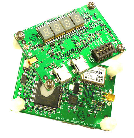
M12M Replacement Receiver GNSS module. Photo: Jackson Labs Technologies
Legacy receiver module
Plug-and-play upgrade for xli server, fury GPSDO
The M12M Replacement Receiver released is form, fit and function compatible to the legacy Motorola M12M and M12+ timing and navigation receivers. It uses an eighth-generation GNSS timing-enabled receiver, allowing 72 GNSS-channel reception with any two GNSS systems being received simultaneously. It adds configurability via USB ports and dual in-line package (DIP) switches and various status displays. GPS, GLONASS, BeiDou, QZSS and SBAS signals can be received. The module supports NMEA, Motorola binary and u-blox binary as well as SCPI (GPIB) communication protocols; is designed to allow plug-and-play retrofit of equipment designed for legacy Motorola receivers; and is certified as a plug-and-play upgrade to the Symmetricom/Microsemi XLI server and the Jackson Labs Technologies Fury GPSDO. It can be used to retrofit products for GLONASS/BeiDou compatibility. The module enhances performance parameters such as time to first fix; position, velocity and timing accuracy; tracking sensitivity; the addition of SBAS (differential compensation) capability; and the addition of external interfaces such as USB and a synthesized frequency output.
High-gain, high-rejection family designed for cell and telecom
The TW3150/52 antennas feature a 50-dB low-noise amplifier (LNA) gain to handle long cable runs often associated with installation on telecommunications towers. They cover the GPS L1 and SBAS (WAAS, EGNOS and MSAS) frequency bands and provide excellent cross-polarization rejection and enhanced multipath rejection.The TW3150 antenna features a four-stage dual-filtered LNA, while the TW3152 antenna includes an additional SAW pre-filter. This provides better than 80-dB of signal rejection above 1610 MHz and below 1545 MHz. The antennas are IP67 and MIL-STD-801F Section 509.4 compliant to withstand challenging environmental conditions.
Provides support for GPS, GLONASS and BeiDou with MediaTek
The ORG1510-MK Multi Micro Hornet is a fully integrated multi-GNSS (GPS, GLONASS and BeiDou) module. The miniature low-power architecture is designed to provide a GNSS component to devices that require fully featured components with small footprints, such as UAVs designed to follow action sports and other fast-moving activities or wearables. The ORG1510-MK contains the MediaTek MT3333 chip, which supports a fast update position calculation rate, and contains an onboard flash memory that does not erase when power is off. It consumes little power with the use of both standby mode and backup mode, and, in advanced applications, a periodic mode that can turn the device on and off when in backup or standby.
Designed for recording sports activities, the FLYPRO XEagle UAV has replaced traditional UAV remote controllers with the XWatch, a smartwatch designed to control the XEagle. Users can control the devices to take off, land and follow, as well as adjust flight height with one click on the wrist within 300 meters. The smartwatch design enables users to fly the aerial vehicles to take high-definition pictures and videos while engaging in intense sports. A voice-control feature allows users to fly the XEagle without moving their hands using commands such as “FLYPRO, take off” and “FLYPRO, follow me”.
Thermal imaging camera core designed for integration
FLIR Tau 2 thermal imaging cameras are suited for demanding applications like UAVs, thermal weapon sights and handheld imagers. Improved electronics now give Tau 2 even more capabilities, including radiometry, increased sensitivity (<30 mK), 640/60 Hz frame rates, and powerful image processing modes that dramatically improve detail and contrast. Since the electrical functions are common between the Tau 2 640, 336 and 324, integrators have direct compatibility between the different camera formats, and Tau camera versions share many of the same lens options.
Amazon’s latest version is designed to deliver packages in 30 minutes
Source: Amazon
A new drone design introduced by Amazon for its planned Prime Air Delivery service is larger than the previous quadcopter and has a more advanced design, including the ability to operate with an auto-loading system that sets the payload inside an internal carrier bay. The hybrid design combines vertical lift and horizontal flight capabilities using lift fans and a pusher prop. The drone is capable of flying at an altitude of about 400 feet (122 meters) at about 55 mph (88 km/h) for a range of 15 miles (24 kilometers). It has sense-and-avoid situational awareness technology and is designed to deliver small packages in under 30 minutes.
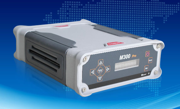
The M300 Pro is a multi-purpose CORS GNSS receiver designed for applications such as positioning infrastructure, active geodetic network, deformation monitoring, machine guidance, harbor construction, land surveying and marine surveying. Designed for reference stations, the M300 Pro tracks GPS, GLONASS and BeiDou (B1, B2, B3), and will track Galileo, QZSS and other coming constellations. Its web server function enables remote control for access, configuration, programming, data download, reboot/restart, firmware update and code registration. It is compatible with many kinds of CORS software, using the standard data format RTCM and the various data transfer protocols such as UDP, TCP and NTRIP. Raw GNSS observation data can be saved in RINEX format and remotely downloaded. Multiple ports can be configured and connected with external sensors such as meteorological sensors, barographs and inclinometers. The PPS output function provides a guarantee for precision timing. It also has the functionality of event mark and external memory.
The Leica Velocity and Displacement Autonomous Solution Engine (VADASE) detects fast movements of man-made and natural structures in real time, running on board Leica reference stations and monitoring receivers. VADASE provides an in-depth look at accurate, high-rate velocity and displacement information of various activities and structures. It gives engineers and researchers complete, precise and reliable monitoring information. VADASE delivers actionable information independent of any GNSS real-time kinematic (RTK) correction service.
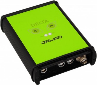
GNSS receiver with onboard memory for data storage
The DELTA-3 receiver has 864 GNSS channels, along with three powerful processors and program memory in a single chip, which uses less power and makes the total system less expensive. The 864 channels allow tracking of all current and future satellite signals. Delta-3 can track and decode the QZSS LEX signal messages. It is a powerful and reliable receiver for high-precision navigation systems, including high-dynamic systems, for machine and traffic control, high-precision surveying, and geodynamics and aerogeophysics applications. Delta-3 can operate as a receiver for post-processing, as a Continuously Operating Reference Station (CORS), or as a portable base station for real-time kinematic (RTK) applications, and as a scientific station collecting information for special studies such as ionosphere monitoring.
A configuration of ArcGIS and a JavaScript application
Photo Survey is designed for local governments to publish street-level photo collections and conduct focused property surveys that can identify blight, damaged structures or construction activity. It leverages location-enabled photos produced by many commercially available cameras and simplifies data processing so street-level photo collections can be gathered on a regular basis. Photo collections can then be combined with relevant survey questions in an ArcGIS Online map, and shared with the Photo Survey application. Once complete, the Photo Survey application can be used by the general public or local government staff to review street-level photos and complete property surveys.
u-blox has released the u‑blox 8 GPS/GLONASS receiver platform. It complements the u-blox GNSS platform portfolio by addressing power sensitive usage, whereas the existing u-blox M8 platform continues to serve applications where navigation performance and highest accuracy are paramount.
u-blox 8 offers significant improvements, compared with its predecessor u-blox 7. The tracking sensitivity has been increased by 4 dBm, and is now -166 dBm.
The enhanced odometer functionality, a new geofencing feature, and optimized preset power save modes can halve the power requirements for sport products. Free-of-charge AssistNow for boosting GNSS acquisition performance, which is available online, offline or as an autonomous service, has been improved. It also makes the new positioning platform ideal for all battery powered devices, especially wearables and sports tracking.
“Nowadays many portable applications rely on a single coin battery; hence low power-spending is crucial,” said Uffe Pless, Product Marketing and Positioning, u‑blox. “u‑blox 8 has been developed for wearables and tracking applications, keeping in mind the need for low power consumption without compromising performance.”
u‑blox 8 is pin-compatible with u‑blox 7. It will be available as a chip and as modules in several form factors. Customer samples of u‑blox 8 chips and modules will be available by Q2 2016.
Swiss startup WayRay has introduced an augmented reality navigation system that projects holographic GPS imagery and driver notifications onto the windshield of a car.
Navion, billed as the “first-ever holographic navigation system for cars,” is placed on a car’s dashboard and projects a virtual route into the regular focal range of the driver. The driver sees the navigation signs laid out directly on the road ahead of the moving vehicle, while the driver’s eyes are safely focused on the road at all times. “We call this concept natural navigation, and we believe it will change the way we drive,” WayRay said in a press release.
In contrast to other augmented reality devices currently on the market, no additional eyewear or headgear is needed to see the image. Navion’s interface provides the driver with clear route indicators even in bright sunlight, the company said.
Navion responds to simple hand gestures and voice control. Certain features are available for use only when the car is stopped or moving at a very low speed.
WayRay is a Swiss-based innovator working with augmented reality technology to develop holographic navigation systems and advance the connected car. The WayRay story goes back to 2012, when Founder and CEO Vitaly Ponomarev had an unexpected experience.
“I was living in Moscow at the time, and I was driving at a low speed while also trying to adjust my brand-new GPS,” Ponomarev said. “My attention got distracted just for an instant and I had my first-ever car accident. The accident had a profound effect on me and I began to think about how the windshield is the perfect place to start when it comes to improving car safety. That began this remarkable journey and inspired the creation of WayRay.”
In its two years of development, the company has emerged as a premier developer in connected cars by applying aerospace technology to land navigation — the principles behind its two key products.
The company first developed the WayRay Element, a smart car tracker that collects data from the car and transforms it into statistics about the driver. Element works in conjunction with the WayRay Navion. Both products are to be released in 2016.
“I think WayRay is the step between where we are now and the future self-driving car that is connected to a city’s infrastructure,” Ponomarev said.
WayRay is headquartered in Switzerland with offices in Moscow and San Francisco.
Antenova Ltd., manufacturer of antennas and RF antenna modules for machine-to-machine (M2M) and the Internet of Things, has released two new modules for GPS and GNSS. Both provide an easy drop-in receiver solution — a way to add a location capability to very small consumer devices.
The two modules are similar, both measuring 9.0 x 9.0 x 1.8 millimeters, with low current consumption, making them suitable for smaller portable devices such as smartwatches, navigation devices, OBD II modules, asset tracking, personal safety, sports cameras and equipment. They are based on a MediaTek processor.
The M10578-A2 module operates with GPS, with a 1-5 Hz update rate, and the M10578-A3 operates with GPS, GLONASS, BeiDou and Galileo with an update rate of 1-10 Hz.
Antenova has added two features to enhance performance of the modules. An internal self-generated orbit prediction uses two GNSS systems simultaneously to give a faster time to fix, and a second high-quality low noise amplifier (LNA) boosts low-powered satellite signals.
The new M10578 modules are the latest in Antenova’s Radionova series of fully optimized RF modules for wireless M2M and embedded devices. Both modules are pin compatible, offering easy integration and upgrade from GPS to GNSS; for the antenna function, Antenova offers the small Sinica SR4G008 GNSS antenna.
The new modules are built on high-grade FR4 substrates with a high density, multi-layered design that places the critical RF functions in the best position for location finding and performance.
The M10578-A2 and M10578-A3 are available to order now.
3Plus, a developer and manufacturer of smart wearable devices, will introduce four new connected products at CES 2016. The huge Consumer Electronics Show (CES) will be held in Las Vegas Jan. 6—9. The new 3Plus wearables line will be on display at CES 2016 in Tech West Sands Expo Booth no. 72745, and the ShowStoppers press event on Jan. 6.
From basic activity trackers to advanced smartwatches, all of the new 3Plus wearables track and record daily activity and sleep. They also use Bluetooth 4.0 to provide smartphone notifications such as calls, e-mails and text messages. They are compatible with both iOS and Android platforms and have corresponding mobile apps.
“Today, a wristwatch is more than just a means to know what time it is and the day’s date,” remarked Jerry Galya, 3Plus vice president of sales. “Digital technology has taken wristwatches in a whole new direction and 3Plus is right at the forefront with many innovative technologies. Our newest wearables are available at a variety of affordable price points depending on what features you are interested in. From the most basic smartphone notifications and fitness tracking, to advanced heart rate monitoring and call answering, 3Plus offers it all.”
The following 3Plus IoT wearables products will be introduced at CES 2016.
3Plus Lite: This connected fitness wearable tracks steps taken, calories burned, distance traveled, duration of sleep and sleep cycles. It has daily life reminders such as when to wake up or take medicine. The 3Plus Lite features a power-efficient OLED display and has an IP67 rating, meaning it is totally protected against dust and water immersion up to three feet.
3Plus Swipe HR: The 3Plus Swipe HR combines smartwatch with an activity tracker. It tracks steps, distance, and calories burned. It also keeps track of daily meals via MyFitnessPal, as well as sleep quality, including periods of deep sleep and restlessness. Other features include a 1.1-inch touchscreen display; heart-rate range alert; and automatic data sync to a smartphone without plugging in or pushing buttons, providing real-time access on a mobile app and notifications on the wrist.
3Plus Touch Smartwatch: Activity tracking includes steps taken, calories burned, distance traveled, heart rate, quality of sleep, and sleep cycles. It even reminds the wearer when to take their medicine or when to eat. The OLED touchscreen display shows the time and date, and smartphone notifications including the name or number of incoming calls, with a built-in microphone for direct answering. Other features include a lightweight lithium-polymer battery with a two-week standby time.
3Plus Time: The look of a traditional timepiece is coupled with digital capabilities. The dial of the 3Plus Time smartwatch measures time with big, bold Roman numeral hours, old-school hour and minute hands, and a digital OLED display for text, call and other smartphone notifications. Tracking activities include steps taken, calories burned, distance traveled, duration of sleep and deep-sleep time. It is available with a choice of a leather or stainless steel band.
Topcon Positioning Group’s DS-200i direct-aiming motorized imaging station is now compatible with the new Autodesk BIM 360 Layout app for the Apple iPad.
The DS-200i is the second total station solution that Autodesk and Topcon have collaborated on for contractors, following the Topcon LN-100 Layout Navigator.
The DS-200i has an electronic distance measurement (EDM) range of up to 1,000 meters (3,280 feet) without the need of a prism, and 5,000 meters (26,240 feet) with one. The built-in wireless WLAN connects the iPad with the BIM (building information modeling) 360 Layout app.
The collaboration provides contractors the ability to connect a coordinated model to the field layout process, helping to increase job-site productivity while improving the accuracy of staked or installed building components, according to a Topcon news release.
Additionally, the DS-200i offers an excellent reflectorless solution for quality assurance and quality control workflows — verifying items in the field are installed correctly as compared to models.
The DS-200i features real-time video imaging with a 5 MP camera. The controller’s touchscreen video and arrow keys are designed to let remote operators view what is being measured, Topcon said, similar to looking through the telescope.
The Autodesk BIM 360 Layout app is available through the Apple App Store.
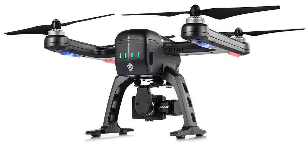
Shenzhen FLYPRO Aerospace Tech Co. has officially released the XEagle, an unmanned aerial vehicle (UAV) equipped with auto follow and obstacle avoidance functions.
Unlike other popular self-flying drone models on the market that are taken off by throwing the aircrafts in the air, which increases the risks of crashing the vehicles, XEagle introduces various features including voice control, smartwatch and automatic obstacle avoiding to offer a better user experience. By liberating both hands, users do not need to have any previous knowledge and experience when handling an XEagle.
Designed for recording sports activities, FLYPRO has replaced traditional UAV remote controllers with XWatch for the new XEagle. XWatch is a smartwatch designed to control XEagle that’s portable and easy to navigate — users can control the devices to take off, land and follow, as well as adjust flight height with just one click on the wrist within 300 meters. The smartwatch design enables users to fly the aerial vehicles to take high-definition pictures and videos while engaging in intense sports such as skiing and mountain bike cycling.
The voice control feature allows hobbyists to fly the XEagle without moving their hands at all — the built-in intelligent voice recognition system responses fast and accurately to commands in both Chinese and English. Users only need to instruct the XEagle with commands such as “FLYPRO, take off” and “FLYPRO, follow me” to launch the XEagle in the air and have it follow automatically.
To lower the risk of crashing the UAV in both takeoff time and during flight, XEagle offers a crash prevention solution by installing four layers of protection. With an infrared obstacle avoidance system and built-in photoelectric sensors, the XEagle can calculate precisely and in real time for obstacles to avoid collisions. The detection is effective when the obstacle is at the distance between 0.1 to 15 meters with relative velocity of 12 meters per second. The UAV can dodge obstacles and barriers while flying in the air by changing its flight path automatically.
As a newcomer in the UAV market, FLYPRO’s technological breakthrough in developing consumer drones not only resolves the safety concerns customers have with other similar UAVs, but also improves user experience through innovative control measures that makes flying the drones as easy as clicking a button, leading the UAV industry with the company’s user-centered philosophy and high product quality standards.
“Now, customers favor UAV products with lower risks associate with operating the aerial vehicles as well as technological innovations that enable users to perform complex tasks without advanced training. When other companies are looking for ways to make UAV products more accessible to the public, FLYPRO has already achieved that with our innovative functions like smart watch control, auto follow and obstacle avoidance that allow everyone to enjoy flying the UAVs for sports and entertainment,” said Lin Hai, founder and CEO of FLYPRO.
Positioning and heading for mission-critical applications
The K528G dual-frequency, multi-constellation GNSS board provides the highest accuracy in differential positioning. It benefits from numerous constellation signals because of its advanced tracking performance of both GPS and GLONASS. The K528G can provide positioning and heading information generated by two antennas. It is designed for guiding and positioning construction engines, dredges, barges, shipping container cranes, mining equipment and intelligent transportation systems.
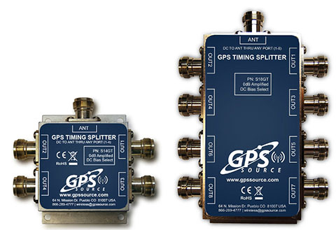
Designed for small-cell and distributed antenna systems
GPS Source has released of a line of GPS/GNSS splitters created for the small-cell wireless and distributed antenna system markets. Specifically designed for the L-band frequency, they can eliminate the cost of multiple antennas and long cable runs in wireless installations. With four or eight outputs, the new line of splitters make it possible to use a single GPS referencing antenna and cable arrangement for multiple synchronized systems. The splitters include features such as DC bias select and amplification. GPS Source RF signal splitters typically operate in conjunction with an active GPS antenna; consequently, a GPS RF signal splitter must have provisions for managing the DC voltage to the active GPS antenna. The S14GT and S18GT splitters will power an external GPS antenna from any of the RF outputs. A “hunt-and-pick” circuit is used to select only one DC input for power should more than one source be connected. Designed for redundancy, if the selected DC bias input should fail, the DC bias will automatically switch to another DC input to ensure an uninterrupted power supply to the active antenna.
For precision industrial, agricultural and military OEM applications
A new series of L1 band wideband antennas for OEM applications is offered in three formats:
▪ TW2106/TW2108 — GPS L1
▪ TW2406/TW2408 — GPS + GLONASS
▪ TW2706/TW2708 — Galileo, BeiDou, GPS + GLONASS
Each antenna type features Tallysman’s Accutenna technology, which provides high rejection of multipath signals, with low axial ratios and tight phase center variations (PCV). Each is available with a brickwall pre-filter option to protect against saturation by high level subharmonic and L-band signals. The antenna printed circuit boards (PCBs) are 56 millimeters in diameter with four plated holes for secure mounting. They are available with a variety of connectors and custom cable lengths, and can be custom-tuned. All of them are REACH and ROHS compliant.
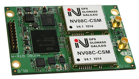
The NV08C-RTK-A is fully integrated multi-constellation L1 heading receiver with embedded real-tiime kinematic (RTK) functionality and compatibility with GPS, GLONASS, Galileo and BeiDou. The NV08C-RTK-A is designed for use in high-accuracy applications that demand low-cost, low-power consumption, a small form factor and high performance, such as construction, mining and industrial; environmental and structural monitoring; machine control; parallel driving systems; precision agriculture; UAVs; and robotics and intelligent machines.
The SLD-100 GNSS Rover accessory facilitates hydrographic measurement in bodies of water up to 100 meters in depth. it is designed for anyone who finds themselves needing to survey into bodies of water, streams and rivers. With survey-grade accuracy, the SLD-100 can be added to any brand GNSS RTK rover to allow for position and depth measurements to be made simultaneously. With a built-in 10-hour lithium battery and transmitter unit with Bluetooth connectivity, the SLD-100 provides standard-depth data streams in several industry-standard NMEA formats at 1 Hz, 4800 bps, providing compatibility with any hydrographic surveying software package. Position and depth information is externally logged on a computer or controller. Included transom mounting hardware enables easy installation.
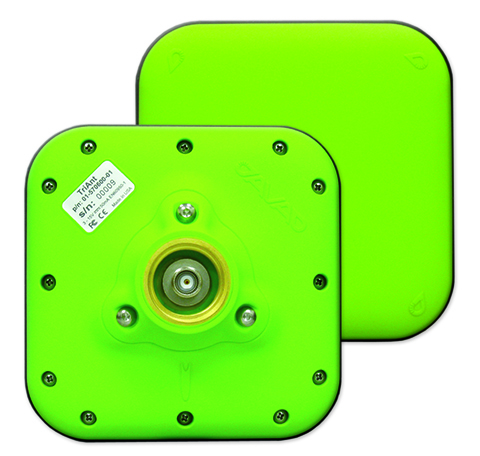
TriAnt is small, thin and rugged high-performance GNSS antenna. It measures 128 x 128 millimeters (mm) square and 39 mm thick. It can be mounted with three screws to flat surfaces. It is designed for applications such as machine control and surround anennas of the TRIUMPH-4X. The antenna cable is routed through the center of the antenna (TNC connector) for protection in harsh environments. The TriAnt can also be mounted on poles (1–14 inches thread) using its mount-pole attachment, which increases the thickness to 54.5 mm.
The X20i L1 GPS receiver by CHC Navigation is powered by a high-precision L1 GPS engine. Its integrated Bluetooth chip enables it to wirelessly collect submeter positions in real- time or centimeter post-processed on an iPhone or iPad. All location-aware apps on the iPhone and iPad are compatible with the X20i. Immediately after pairing and answering the security question allowing the X20i to take control of location services on the iOS device, 1 million iOS applications are capable of utilizing the high-accuracy data of the X20i, and become accurate to either 1 foot or 1 centimeter. Apps that can make use of the high accuracy include TerraGo Edge, ESRI’s ArcView Connector and those by CarteGraph Systems.
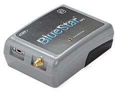
BlueStarGPS offers both GPS and GNSS options in a rugged, lightweight package. The BlueStarGPS device was designed to meet sub-meter mapping and data-collection needs in the pipeline and utility industries. It provides sub-meter precision without post-processing, and maintains accurate positioning when the SBAS signal is obstructed. This means it can function under trees, around buildings and in rugged terrain where other receivers can fail. The BlueStarGPS is designed specifically for use with Android mobile devices, such as smartphones, tablets or notebook computers, as well as cable and pipe “locating” tools with a connectivity range of up to 1 kilometer.
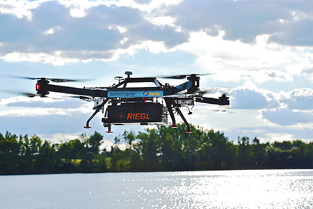
UAV measures through water surfaces of rivers, lakes
The RIEGL BathyCopter is a small-UAV-based surveying system capable of measuring through the water surface. It’s suitable for generating profiles of rivers or water reservoirs. The platform design integrates a topo-bathymetric green laser depth meter, an APX 15 inertial measurement unit (IMU)/GNSS with antenna, a control unit and a digital camera. Applications include generation of river profiles, survey of reservoirs and canals, landscaping, support of construction projects, and surveys for planning and carrying out hydraulic engineering work.
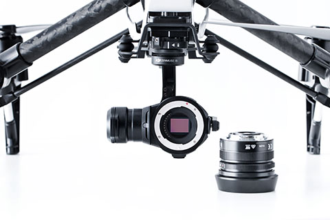
The Zenmuse X5 is a micro four-thirds (M4/3) camera designed specifically for aerial use. With a large sensor, aerial image makers will be able to capture up to 13 stops of dynamic range, enabling capture of high-resolution 16-megapixel photos or 4 k, 24 fps and 30 fps videos in complex lighting environments. It supports four interchangeable lenses. The Zenmuse X5 is designed for creation of high-quality aerial maps and 3D models, industrial and utility inspection, and professional video capture.
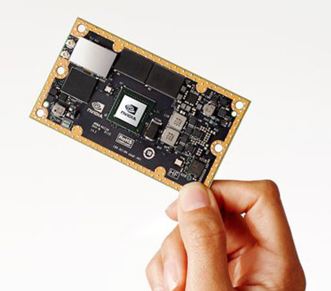
The NVIDIA Jetson TX1 module is designed to power smart devices — including drones that don’t just fly by remote control, but navigate their way through a forest for search and rescue. It is an embedded computer designed to learn to recognize objects or interpret information, incorporating capabilities such as machine learning, computer vision and navigation into a single system. This technology expands the ability of machines to operate on their own and adapt to their surroundings by recognizing images, processing conversational speech, or analyzing a room full of furniture and finding a path to navigate across it.
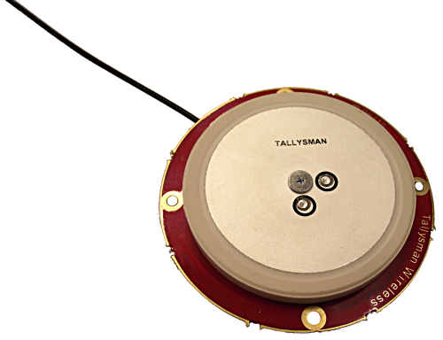
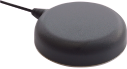
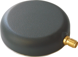
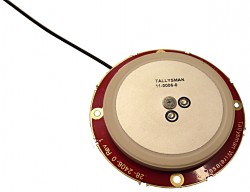
Tallysman has introduced the TW2920 antenna for simultaneous reception of L-band correction signals and all of the upper band GNSS signals, including GPS L1, GLONASS G1, Galileo E1 and BeiDou B1.
The TW2920’s 1-dB bandwidth covers 1525-1559 MHz for the L-band downlink and 1559-1610MHz for the upper-band GNSS.
The LNA of the TW2920 provides 28dB of gain; the TW2940 is a higher gain version with 35-dB LNA gain. The TW2926 antenna is an unhoused OEM version of the TW2920 with 28-dB of gain.
The antennas employ Tallysman’s Accutenna technology, which provides strong cross-polarization rejection for greatly improved multipath rejection, low axial ratio and tight Phase Center Variation (PCV).
All of the antennas include a sharp pre-filter to protect against sub-harmonic signals such 700MHz LTE and strong near frequency signals such as Wi-Fi.
The Tallysman TW2920.
The Tallysman TW2940.
The Tallysman TW2926.
The TW2920 and TW2940 have metal bases with wide temperature range plastic radomes, 57mm in diameter and 15mm in height, with a magnetic mount or adhesive mount along with four tapped screw holes. They are IP67 compliant and available with either a watertight SMA connector on the bulkhead or with a RG174 cable with your choice of connector.
The TW2926 OEM version of the antenna is 56 mm in diameter and has four drilled plated holes for secure mounting within customers’ products. This antenna can be custom tuned to ensure optimal performance within an enclosure.