NVS Technologies AG has launched an L1 RTK+Heading GNSS receiver. The NV08C-RTK-A is fully integrated multi-constellation satellite navigation receiver with embedded RTK functionality and compatibility with GPS, GLONASS, Galileo and BeiDou.
NV08C-RTK-A is specifically designed for use in high-accuracy applications, demanding low-cost, low-power consumption, small form factor and high performance, such as construction, mining and industrial; environmental and structural monitoring; machine control and automation; parallel driving systems; precision agriculture; UAVs; and robotics and intelligent machines.
More Features
L1 GPS, GLONASS and SBAS
Centimeter-level positioning in RTK mode
Enhanced RAIM for 3D and RTK modes
Three-stage filtration for high out-of-band interference immunity
Industrial operating temperature range -40°C to +85°C
Bruce Donaldson of Red Hen Systems LLC gave a presentation about MediaMapper Mobile, an Android app with extensive utility for ISR professionals and civilians, on a panel at the Innovative GEOINT Application Provider Program (IGAPP). IGAPP was held in St. Louis on Oct. 20. Donaldson is Red Hen’s Intelligence Surveillance and Reconnaissance (ISR) manager.
During his years of field service, Donaldson worked to address the need for Mobile Geo-Intelligence platforms that can rapidly collect, process and disseminate geospatial data and other multimedia within 24 hours of a mission.
At its essence, MediaMapper Mobile enables users to:
Geotag video, photos, audio and other notes. Annotate ground track logs. Create audio and visual notes connecting them to points of interest. Tag features from a touchscreen.
See track log (a.k.a breadcrumb trail). View on a map along with GPS details about location, including latitude, longitude, and altitude. Inspect media objects and other sensor streams. Share with others with XML and KML/KMZ.
Use with Vectronix, LTI or Trimble laser rangefinder (compass, tilt, range, calibration). Or, triangulate your location by taking two or more photos of the same object. Once the feature is identified in these images, MediaMapper Mobile will do the calculation to show you where the object was and where you were when you took the photos.
Configure settings for GPS devices, cameras, shuttering automations for intervalometry (time/distance).
Log files, manage collection projects, and complete inspection forms on site.
Transfer your raw multimedia data files and their track logs from your Android device to a laptop, tablet or server to view and analyze on Google Earth, Esri ArcGIS, FalconView or MediaMapper for desktop.
Patrol/Event Recorder with NMEA compliant record schemas compatible to MediaGeotagger and GEM2MISB for Esri ArcGIS and the free Full Motion Video module.
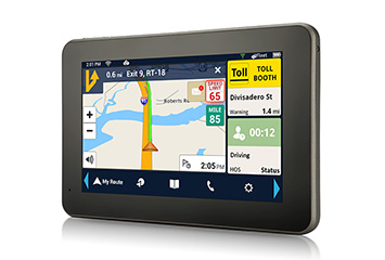
The Magellan RoadMate RC9496T-LMB commercial navigator.
Magellan is integrating its RoadMate RC9496T-LMB fleet navigation device with Position Logic’s advanced GPS tracking software solution. The partnership allows Position Logic service providers to leverage all Magellan RoadMate RC9496T-LMB devices.
The RoadMate RC9496T-LMB, a 7-inch Android GPS fleet navigation device, is available now to current and prospective Magellan and Position Logic customers. Position Logic, a division of KORE, provides precision location-based services for business-to-business applications.
The Magellan and Position Logic integration delivers a powerful and seamless end-to-end communication and navigation solution for fleets, the companies said. The solution includes the RC9496T-LMB, an active mobile terminal, allowing real-time two-way communication between driver and dispatch when paired with Position Logic’s GPS tracking software. Users can send and receive important information to immediately identify driver status including route-receipt, in-route or on-scene, and deliver real-time messages to improve driver productivity. The solution delivers critical information for field service fleets, emergency services, roadside assistance and many more applications.
“Position Logic is an innovative technology leader in the location based services space. We are pleased to partner with them and offer the Magellan RC9496T-LMB to Position Logic customers,” said Stig Pedersen, associate vice president of product management for Magellan. “The combination of our two services delivers a highly efficient and flexible way for dispatchers to communicate with drivers in real-time, saving time, money and frustration.”
The RC9496T-LMB is also connected to Magellan’s SmartGPS Eco cloud, providing drivers and fleet managers with customizable time and money saving content such as: real-time fuel price information, weather and truck speed limit warnings.
“We are pleased to have the RoadMate RC9496T-LMB integrated. The Magellan integration further complements our Workflow/Dispatch module; improving communication between the dispatcher and driver and enhanced stop management,” said Felix Lluberes, executive vice president, advanced applications, KORE. “I am certain our service providers will be able to leverage the device and deliver more comprehensive services.”
The Magellan RoadMate RC9496T-LMB is available now. It has an MSRP of $399.
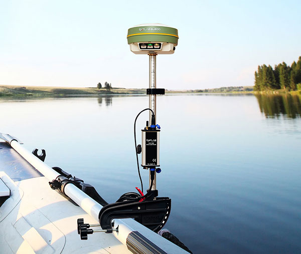
Swedish-based Survey and GIS equipment maker Satlab Geosolutions AB has announced the availability of its SLD-100 GNSS Rover accessory to facilitate Hydrographic measurement in bodies of water up to 100 meters in depth. It is designed for those who find themselves needing to survey into bodies of water, streams and rivers.
With survey-grade accuracy, the Satlab SLD-100 can be added to any brand GNSS RTK Rover to allow for position and depth measurements to be made simultaneously. With a built-in 10-hour lithium battery and transmitter unit with Bluetooth connectivity, the SLD-100 provides standard depth data streams in several industry standard NMEA formats at 1Hz, 4800 bps, providing compatibility with any hydrographic surveying software package.
“Our new SLD-100 survey receiver is extremely easy to use with position and depth information externally logged on a computer or controller,” said Birol Güçlüer”, CTO and partner of Satlab. “With the included transom mounting hardware, installation is quick and easy.”
The SLD-100 is available now for a suggested retail price of US$2995.
EndRun Technologies has launched two GPS-based timing products.
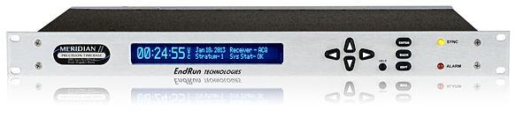
Meridian II Precision TimeBase.
The Meridian II Precision TimeBase references GPS to provide ultra-accurate time (10 nanoseconds to UTC) and frequency. At the core of Meridian II is a new GPS receiver that EndRun optimized to deliver a variety of traditional- and network-based time and frequency signals.
“The second-generation Meridian II continues EndRun’s heritage of pushing the envelope by delivering an industry-best, UTC time accuracy of 10 nanoseconds.” said Ron Holm, marketing manager, EndRun Technologies. “Meridian II also introduces a security-hardened, high-bandwidth network interface to synchronize evolving, network-centric applications via the Network Time Protocol (NTP) and IEEE-1588 Precision Time Protocol (PTP). Frequency standard customers will be happy to know that the revolutionary ultra-low phase noise and short-term stability performance of the original Meridian continues to be provided.”
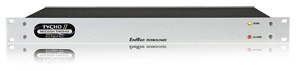
Tycho II Precision TimeBase.
Also new is the Tycho II Precision TimeBase time and frequency standard, which references GPS to provide exceptional time (25 nanoseconds to UTC) and frequency (<1×10-13 per day) accuracy in a security-hardened, network-centric platform.
At the core of Tycho II is a new EndRun GPS receiver that is optimized to take advantage of improved GPS system accuracy. Tycho II delivers a variety of traditional and network-based time and frequency signals and services via a modular, customer-configurable platform. Operational status is easily monitored via the network interface (HTTPS, SNMP, SSH). Intuitive charts are provided to assess current and historical performance of Tycho II, its GPS receiver and reference oscillator.
“The second-generation Tycho II provides our customers with a cost-effective, high-performance time and frequency standard without compromise to security and reliability,” said Dan Paine, sales and support manager, EndRun Technologies. “In addition, Tycho II uses the same network-centric core of our ultra-high performance Meridian II TimeBase. This enables operation as a high-bandwidth, Network Time Protocol (NTP) server and optional IEEE-1588 Precision Time Protocol (PTP) Grandmaster.”
Both the Meridian II and Tycho II have modular architecture that allows customers to configure them to meet specific application requirements.
The units support mission-critical operations in a wide range of government and commercial applications including telecommunications, satellite communications, digital video broadcast, simulcast radio, test range, test and measurement, calibration labs and power utilities.
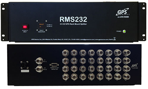
GPS Source has released a GPS/GNSS rackmount splitter with dual antenna inputs and antenna health monitoring. Developed for the wireless industry, the dual-input splitter provides a GPS timing signal to up to 32 GPS/GNSS synchronization modules and receivers. Its design ensures the GPS timing signal is always available, even in the event of an antenna or cable failure, the company said.
Like GPS Source’s GPS rackmount splitters, the new rackmount splitter amplifies and splits the GPS/GNSS signal. However, the new splitter also includes dual GPS antenna input ports, a health monitor and sensor switch. Up to 32 GPS/GNSS receivers or timing synchronization modules can access the signal at one time. Antenna redundancy is acquired through the use of primary and backup antennas. The sensor monitors the health of the primary antenna connected to the splitter. Based on the information provided by the sensor, the splitter will automatically switch antennas. The ability of the splitter to switch antennas allows all connected GPS devices to remain fully functional in the event of an antenna failure, which is important in today’s wireless environment.
“The demand for high-speed wireless internet and data network access over a wide area has grown at a record pace,” said Robert Horton, CEO of GPS Source. “This growth has led to a strong demand for solutions that support more than one function because of limited space and increased usage. The new rackmount splitters, RMS216 and RMS232, will keep multiple timing synchronization modules operating for an extended period when a GPS antenna or cable fails. This extended period gives a solution provider supporting a cell site, base station, or DAS network, the ability to identify and fix any GPS/GNSS antenna or cable problem before other challenges arise.”
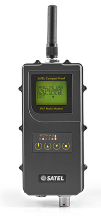
Satel’s new UHF radio data modem Compact-Proof, designed for outdoor measurement applications, features autonomous rechargeable battery power and a robust housing with IP67 protection.
Compact-Proof from Satel gives users double advantages with a powerful lithium-ion battery and the EASy radio data technology including a display and a robust housing with IP67 protection, the company said. With transmitting power of 1,000 mW, it can be operated fully autonomously as a repeater station in the field for more than 15 hours. The power can also be supplied parallel via an external rechargeable battery with a solar panel; alternatively, the Compact-Proof can be recharged overnight, and within five hours it is ready for the next work day.
The user-friendly installation, robust IP67 housing and 4-pin and 8-pin ODU connections make the new radio data modem Compact-Proof attractive for measurement applications, Satel said. The device features all functions of the Satel radio data modems EASy and 3AS and is 100 percent compatible with these solutions.
In addition, it supports the radio protocols of Pacific Crest, Trimble and other GNSS providers, which expands the areas of application.
Whether in the rainforests of Vietnam or in the Arctic, the temperature range of -30°C to +65°C and the frequency ranges of 330 MHz…420 MHz and 403 MHz…473 MHz make the Compact-Proof a reliable partner for all outdoor applications, Satel said. The housing features a robust, compact design with a display and foil keyboard.
As a light version — without an internal battery — the device offers numerous advantages for outdoor applications and even withstands the harsh conditions of machine control environments, for example.
In Germany, radio data transmission solutions from Satel are distributed exclusively by systems provider Welotec.
The Averna RP-6100 Multi-Channel RF Record & Playback for RF application testing allows users to tecord real-world signals such as GNSS, HD Radio, LTE and Wi-Fi — plus impairments — to significantly advance projects and harden product designs. Skydel Solutions’ GNSS simulator is an entirely software driven innovative and cost-effective simulator that works with the RP-6100, enabling users to test corner cases and future events with a real-time GNSS solution.
PCTEL’s GPS/GLONASS high-performance asset tracking and synchronization helix antennas are now available commercially. The antennas capture the frequencies needed for GPS, Galileo and GLONASS satellite reception. This cross-compatibility allows global OEMs to use one standard platform to serve both European and U.S. markets.
PCTEL uses its proprietary filtering design to allow wideband coverage while achieving superior out-of-band rejection. With an IP67 rating, the small form-factor helix antennas will withstand harsh environments.
AsteRx-U and AsteRx-U Marine multi-constellation dual-antenna receivers incorporate the latest GNSS tracking and positioning algorithms and interference mitigation. Machine-control users in the agricultural, construction, marine and mining industries benefit from a complete system with integrated UHF radio, Wi-Fi, USB, Bluetooth and cellular connectivity and a spectrum analyzer. All configurations can be done via the on-board web interface.
The AsteRx-U has decimeter- and centimeter-level RTK positioning including TerraStar. The AsteRx-U Marine also supports Veripos PPP augmentation services.
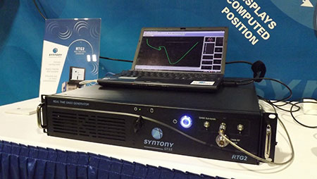
The RTG2 is a GNSS constellation simulator that generates realistic GNSS RF signals, taking into account current and future GNSS constellations. RTG2 is able to entirely simulate one or many constellations (GPS, Galileo, etc.) including satellite-based augmentation systems such as WAAS and EGNOS.
The generator is entirely configurable (troposphere and ionosphere effects, simulated receiver trajectory, etc.) through a user-friendly interface accessible on a separate PC through Ethernet. RTG2 is highly flexible and scalable, offering hardware and software upgrades for capability extensions.
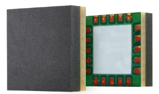
Telit’s Jupiter SE873 GNSS receiver with flash memory.
GNSS Receiver with Flash Memory
The Jupiter SE873 GNSS receiver is a complete multi-constellation position, velocity and time engine that delivers versatile performance in harsh environments. The 7 x 7 x 1.85 mm module has serial quad I/O flash memory, an integrated low noise amplifier, SAW filter, TXCO and real-time clock. The Jupiter SE873 supports Assisted GPS (both autonomous and server-based) plus SBAS, which improve time-to-first-fix and position accuracy. AGPS data is stored in flash memory and is available even after all power has been removed and then restored. This is especially important for battery-operated equipment.
The SE873 supports the entire GNSS spectrum: GPS, GLONASS and BeiDou, and it is Galileo ready. It delivers simultaneous low-power tracking of GPS and GLONASS or GPS and BeiDou.
Antenna maker Tallysman announces the availability of a family of high-gain (50 dB) and high-rejection timing antennas.
The antennas are specifically designed for timing applications in high-density cell/telecommunications tower applications where high levels of near-out-of-band interfering signals can be expected. They feature a 50-dB LNA gain to handle long cable runs often associated with installation on telecommunications towers.
The TW3150/52 antennas cover the GPS L1 and SBAS (WAAS, EGNOS and MSAS) frequency band and employ Tallysman’s unique Accutenna technology to provide excellent cross-polarization rejection and greatly enhanced multipath rejection.
The TW3150 antenna features a four-stage dual-filtered LNA, while the TW3152 antenna includes an additional SAW pre-filter to provide exceptional rejection of close out-of-band signals and additional protection against saturation by high-level sub-harmonic and L-Band signals. This provides better than 80-dB of signal rejection above 1610 MHz and below 1545 MHz, Tallysman said.
The antennas have a permanent mount, IP67 and MIL-STD-801F Section 509.4 compliant housing with metal base and an extended temperature range plastic radome, and is specifically designed to withstand the most challenging environmental conditions.
Two options for mounting are available: an L-bracket (P/N#23-0040-0) or a pipe mount (P/N#23-0065-0).
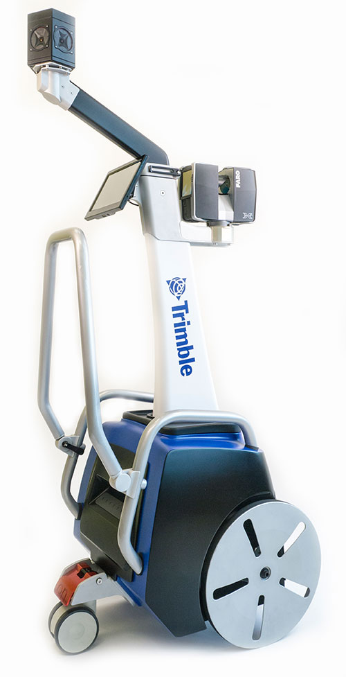
Trimble has introduced its next-generation Trimble Indoor Mobile Mapping Solution (TIMMS) that produces fast and accurate maps of difficult-to-navigate indoor spaces and translates them directly into 2D and 3D models of structured interiors.
TIMMS 2 is a fusion of technologies for capturing spatial data of indoor and other GNSS denied areas, the company said. It provides both lidar and spherical video, enabling the creation of accurate, real-life representations of interior spaces and all of their contents. The maps are geo-located, meaning that the real world positions of each area of the building and its contents are known and can be easily placed and oriented in a wide area model.
TIMMS 2 is smaller, lighter and more easily maneuverable than its predecessor. It can negotiate tight corners, closets and catwalks, and can be carried up and down staircases where no elevator is available for travel between building levels.
“The new Trimble Indoor Mobile Mapping Solution has been designed with greater emphasis on ease of use. It is very easy to maneuver, lift, ship and operate,” said Louis Nastro, director of Land Products at Applanix, a Trimble Company. “Our extensive experience with a broad range of projects with the previous generation TIMMS has led to a number of enhancements in data collection, processing and workflow management — making an indoor mapping project a seamless experience for users both pre- and post-mission. Whatever the building type and shape, TIMMS 2 can deliver exceptional results, both in accuracy and ease-of-use.”
Building on the success of the first-generation solution, TIMMS 2 also provides improved software workflow to manage the complete process from collection through post-processing to model production. Fully compatible with POSPac MMS, Applanix’ post-processing suite, TIMMS data can be presented in a variety of ways, including integration into Trimble Business Center and other infrastructure management or CAD packages.
Because of its increased efficiency, speed and ease-of-use, TIMMS 2 is an effective and high-productivity indoor mapping solution for buildings and facilities of all shapes and sizes, according to Trimble, including large or small areas, multi-level, industrial or commercial spaces. Users can obtain holistic 3D indoor geospatial views of all kinds of infrastructure including public buildings (government offices, schools, hospitals); industrial facilities (factories, warehouses); transportation hubs (airports, train stations); retail spaces (malls, concourses); entertainment venues (theatres, auditoriums, sound stages); and residential property (especially multi-occupancy high-rise buildings).
Maps and models of these spaces can be used for activities including revenue management and space planning; emergency preparedness and disaster planning; and historical building conservation and preservation. In addition, the base map provides a platform on which building owners and managers can serve location-based services.
Manufactured and sold by Applanix, TIMMS 2 indoor mobile mapping solution is available in the first quarter of 2016.
Below, Eric Liberty of Applanix, a Trimble company, gives an overview of Applanix’s POS AV, POS AVX 210 and TIMMS indoor mobile mapping system at INTERGEO 2015, which was held Sept. 15-17 in Stuttgart, Germany.
Trimble has introduced its next-generation Trimble Indoor Mobile Mapping Solution (TIMMS) that produces fast and accurate maps of difficult-to-navigate indoor spaces and translates them directly into 2D and 3D models of structured interiors.
TIMMS 2 is a fusion of technologies for capturing spatial data of indoor and other GNSS denied areas, the company said. It provides both lidar and spherical video, enabling the creation of accurate, real-life representations of interior spaces and all of their contents. The maps are geo-located, meaning that the real world positions of each area of the building and its contents are known and can be easily placed and oriented in a wide area model.
TIMMS 2 is smaller, lighter and more easily maneuverable than its predecessor. It can negotiate tight corners, closets and catwalks, and can be carried up and down staircases where no elevator is available for travel between building levels.
“The new Trimble Indoor Mobile Mapping Solution has been designed with greater emphasis on ease of use. It is very easy to maneuver, lift, ship and operate,” said Louis Nastro, director of Land Products at Applanix, a Trimble Company. “Our extensive experience with a broad range of projects with the previous generation TIMMS has led to a number of enhancements in data collection, processing and workflow management — making an indoor mapping project a seamless experience for users both pre- and post-mission. Whatever the building type and shape, TIMMS 2 can deliver exceptional results, both in accuracy and ease-of-use.”
Building on the success of the first-generation solution, TIMMS 2 also provides improved software workflow to manage the complete process from collection through post-processing to model production. Fully compatible with POSPac MMS, Applanix’ post-processing suite, TIMMS data can be presented in a variety of ways, including integration into Trimble Business Center and other infrastructure management or CAD packages.
Because of its increased efficiency, speed and ease-of-use, TIMMS 2 is an effective and high-productivity indoor mapping solution for buildings and facilities of all shapes and sizes, according to Trimble, including large or small areas, multi-level, industrial or commercial spaces. Users can obtain holistic 3D indoor geospatial views of all kinds of infrastructure including public buildings (government offices, schools, hospitals); industrial facilities (factories, warehouses); transportation hubs (airports, train stations); retail spaces (malls, concourses); entertainment venues (theatres, auditoriums, sound stages); and residential property (especially multi-occupancy high-rise buildings).
Maps and models of these spaces can be used for activities including revenue management and space planning; emergency preparedness and disaster planning; and historical building conservation and preservation. In addition, the base map provides a platform on which building owners and managers can serve location-based services.
Manufactured and sold by Applanix, TIMMS 2 indoor mobile mapping solution is available in the first quarter of 2016.
The R2 GNSS receiver works with Trimble handheld devices and iOS, Android or Window mobile handhelds, smartphones and tablets using Bluetooth or USB connectivity. When paired with a mobile device, the receiver adds professional-grade GNSS capabilities for better accuracy. The rugged Trimble R2 provides GIS and survey professionals the flexibility to choose the mobile device, workflows and accuracy they need based on applications.
The Trimble R2 GNSS receiver is compact and portable, weighing 2.4 pounds. With one button operation and field swappable battery, the receiver can be pole or vehicle mounted or carried on a backpack. The R2 is a multi-constellation receiver that supports GPS, GLONASS, Galileo, BeiDou and QZSS satellite signals as well as SBAS.The Trimble R2 can achieve sub-meter to centimeter positioning.
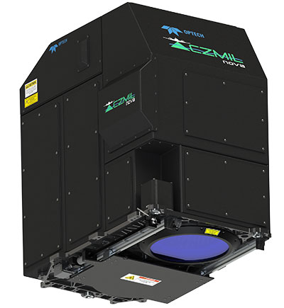
The Optech CZMIL Nova airborne bathymetric mapping system.
Coastal and Marine Mapping
The Optech CZMIL Nova airborne bathymetric mapping system is designed for coastal and marine mapping.With a powerful yet efficient laser, it maps deeper while flying higher, reaching depths of 80 meters in clear waters. The enhanced design and automated processing tools produce simultaneous high-resolution 3D data and imagery of the beach and shallow water seafloor, including coastal topography, bathymetry, benthic classification and water column characterization. Its bathymetric lidar is integrated with a hyperspectral imaging system and digital metric camera. Optech HydroFusion, an end-to-end software suite, handles data from all three sensors.
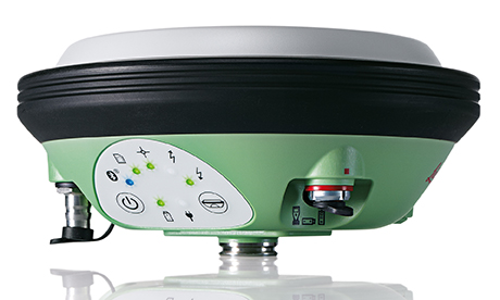
The latest generation Leica Viva GS14 GNSS receiver now supports Verizon CDMA solutions along with all standard 2G/3G networks and UHF TX/RX radio in a single device, making it a professional GNSS receiver with all three communication systems built in. Users simply slide in their SIM card to experience instant connectivity for faster and easier field communications and SmartNet RTK corrections. No external equipment is required.
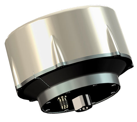
The VeraPhase 6000 family of antennas provides the lowest axial ratios (horizon to horizon, through all azimuths) across all GNSS frequencies (70 percent), a tight PCV (± 1mm through all frequencies, azimuths, and elevations), and a consistent PCO through all frequencies.
The performance of the VeraPhase rivals that of choke ring antennas, but is much lighter, smaller and more economical. The antenna family is designed for use in survey, precision RTK and reference antenna applications.
The VeraPhase 6000 also provides an available PCB within the base of the antenna for integration of a custom system board such as a dual-band or RTK GNSS receivers or other applications.
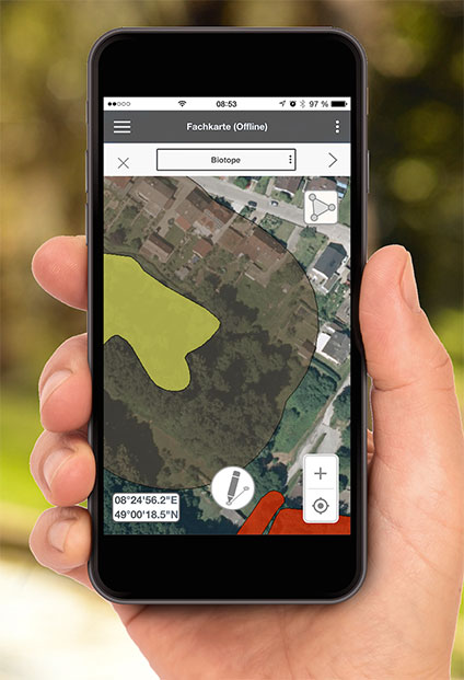
The GIS 2go Cadenza software suite for mobile GIS visualizes geodata and attribute data for efficient result presentation. This version offers new features for tablet or smartphone, allowing users to transfer maps from Cadenza or ArcGIS for Desktop to mobile devices for use offline and availability to others via the cloud, creating an extended field workstation. The mobile app also features faster exporting and optimized use of land registers for geometry and attribute editing in the field.
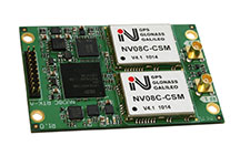 NVS Technologies AG has launched an L1 RTK+Heading GNSS receiver. The NV08C-RTK-A is fully integrated multi-constellation satellite navigation receiver with embedded RTK functionality and compatibility with GPS, GLONASS, Galileo and BeiDou.