Phase One Industrial, a manufacturer and provider of medium-format aerial digital photography equipment and software solutions, is offering the iXU-R camera series. Available in 80 MP, 60 MP and 60 MP achromatic versions, the cameras feature dedicated interchangeable 40 mm, 50 mm and 70 mm Phase One Rodenstock lenses equipped with central leaf shutters that can be quickly changed in the field, offering flexibility in aerial applications.
The Phase One iXU-R systems have been designed to address the aerial data acquisition market’s needs for a small, lightweight camera with the high resolution of a medium format system, plus high-performance optics, flexibility to fit into small places and Phase One’s fastest 80 MP platform. For example, the iXU-R 180 is built around a large 80-megapixel sensor, with 10,328 pixels cross-track coverage yet it is compact enough to be easily integrated into a small gimbal or pod space or an oblique/nadir array. Or it can be used as a standalone photogrammetric camera with optional Forward Motion Compensation.
Cameras are easily integrated into new or existing setups with USB 3.0 connectivity for control and storage via the Phase One iX Capture application. All Phase One aerial cameras offer direct communication with GPS/IMU systems and the ability to directly write data to the image files.
“As the use of UAVs and small aircraft increases dramatically around the world, and every gram in a payload counts, Phase One Industrial is committed to offering small and lightweight cameras without sacrificing data accuracy, image quality and resolution,” said Dov Kalinski, general manager of Phase One Industrial.
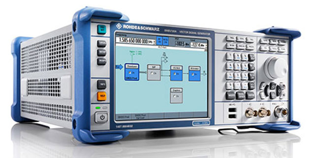
Rohde & Schwarz designed its GNSS simulator for the R&S SMBV100A with a focus on production testing of GNSS receivers.
Rohde & Schwarz now offers a new, speed-optimized production tester — the R&S SMBV100A vector signal generator equipped with the R&S SMBV-P101 package.
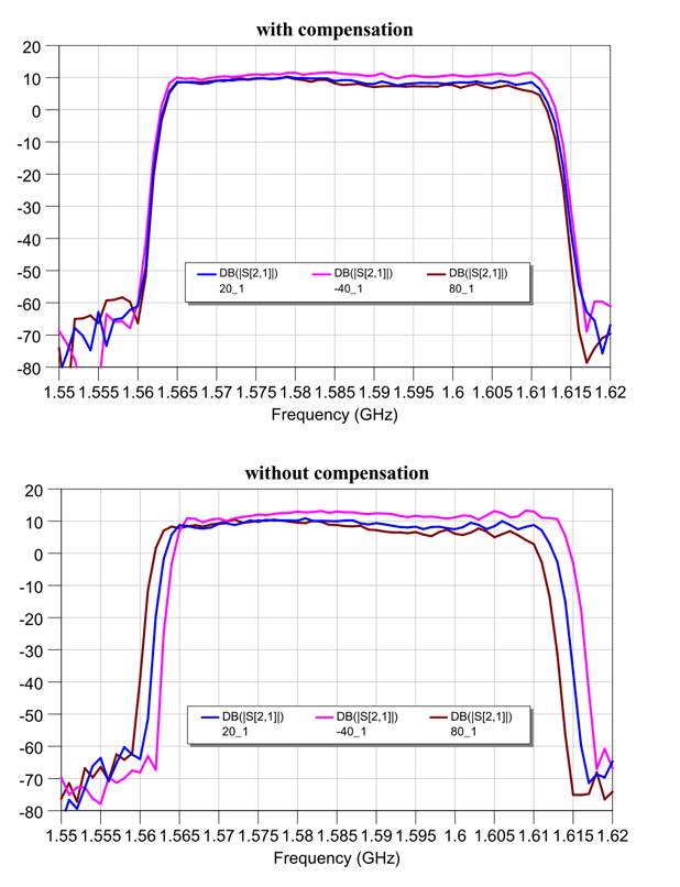
During production testing of modules and receivers for satellite-based communications, the basic GNSS signal reception and the connection between the antenna and GNSS chipset need to be checked. The GNSS production tester simulates separate satellites for the GPS, GLONASS, BeiDou and Galileo navigation standards in the L1/E1 band specifically for these production tests.
The four satellite constellations can be activated individually, each with a high dynamic range of 34 dB. Level changes can be made on the fly without interrupting the signal, enabling users to simultaneously perform independent sensitivity tests for each navigation system. The 1 pps or 10 pps GNSS marker allows exact time synchronization between the tester and the DUT. Pure, level-stable CW signals can also be generated to calibrate the test setup or to simulate interferers.
The R&S SMBV-P101 option additionally offers test functions for efficient characterization of GNSS chipsets, Rohde & Schwarz said. As a result, a receiver’s ability to handle high-movement dynamics can be verified quickly and cost-effectively. To do this, users can access both predefined and user-defined Doppler profiles, from which the R&S SMBV100A automatically generates the appropriate satellite signal.
The R&S SMBV-P101 GNSS production tester package for the R&S SMBV100A is now available from Rohde & Schwarz.
Garmin’s eTrex Touch 25, 35 and 35t outdoor handhelds have an updated user interface and 2.6-inch capacitive touchscreen display. The eTrex Touch series also features activity profiles for navigation for multiple activities and an enhanced track manager to start and stop recording.
The eTrex Touch series has a high-sensitivity, WAAS-enabled GPS receiver with GLONASS support and HotFix satellite prediction to locate users’ position quickly and precisely, even in heavy cover and deep canyons. All units have a three-axis tilt-compensated electronic compass, which gives directional information even when standing still. The eTrex 35 and 35t also have a barometric altimeter to get more accurate altitude, elevation and climb information, as well as indications of weather changes.
Garmin, www.garmin.com
Fleet Management
Supervisor App for Fleets
The Supervisor app for the FieldMaster suite of mobile applications allows managers to leave the office and still have visibility into their fleet and mobile workers from their smartphone or tablet, as well as manage day-to-day operations remotely.
FieldMaster Supervisor is available with Trimble Fleet Management and Work Management. Features include viewing the team’s locations on a map; seeing their job progress, including tasks at risk; finding the nearest worker to another team member or customer; turn-by-turn navigation; inspecting job performance and documenting status in the field; and receiving vehicle and driver performance alerts in real-time.
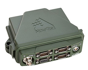
NovAtel’s SPAN GNSS/INS technology is now available on the company’s OEM625S dual-frequency SAASM GPS plus civil RTK receiver. SPAN offers system developers with SAASM requirements the benefit of continuously available 3D positioning, velocity and attitude (roll, pitch, yaw) for their defense applications. Authorized defense customers need access to the Precise Positioning Service (PPS) for DOD applications. When keyed, the existing OEM625S board-level receiver provides an RTK PPS solution by taking the raw measurements from an L-3 XFACTOR SAASM and applying them to NovAtel’s RTK algorithm. SPAN technology couples NovAtel’s precision GNSS receivers with robust IMUs to provide a more reliable, stable solution, even during short periods of time when satellite signals are blocked or unavailable.
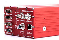
The Averna RP-6100 series is an RF tool offering high-performance record-and-playback and real-time simulation in one platform for RF application validation.
The RP-6100 can capture all GNSS bands, as well as HD Radio, Wi-Fi, LTE, radar, and cognitive radio — plus impairments — to advance RF projects and harden product designs. It features up to four channels, 160 MHz of recording bandwidth, tight channel synchronization, an extended frequency range of 10 MHz to 6 GHz and 14-bit resolution. The RP-6100 can be equipped with Skydel Solutions’ software-defined, real-time GNSS simulator, which delivers easy setups, integrated maps, dynamic scenario creation, high precision and tight parameter controls to enable highly repeatable simulations of current and future GNSS conditions, as well as corner cases.
The AirPrime WP Series of smart wireless modules is designed for the development of connected products. The WP Series provides an integrated device-to-cloud architecture enabling developers to build a Linux-based product using a single module that sends user and product data to the cloud. The AirPrime WP series offers an application processor, GNSS receiver, and cellular modem with an optional ultra-low power mode that reduces power consumption by 200 times, opening up new use-case possibilities for cellular connectivity.
The Inertial+ by OxTS improves measurements from a GPS receiver.
OxTS has successfully integrated a Locata receiver with its Inertial+ to create the first Locata+INS device, according to both companies. The device is capable of achieving centimeter-level accuracy where GPS systems fail.
The Inertial+ series, first developed in 2008, was designed for users who had an external GNSS receiver already, but still wanted to gain the benefits of an inertial system. The company has been able to combine OxTS’ Kalman filter and expertise in GNSS/IMU integration with its existing systems, meaning the user doesn’t have to pay for survey-grade integrated receivers.
Over the years, a number of popular GNSS receivers have been integrated with the Inertial+ to keep up to date with the market and make sure customers with the latest models can take advantage of the benefits the Inertial+ brings, OxTS said. Now, the Inertial+ has expanded from GNSS receivers and become the first inertial navigation system to integrate a Locata receiver, combining the many benefits of both systems, the companies said.
Locata is an innovative positioning system designed to complement rather than replace GPS, by addressing the issues and shortfalls of GNSS. As always, the Inertial+ allows Locata users to take advantage of their existing technology while enjoying the extra layer of measurements an aided-inertial navigation system brings.
Locata enables positioning in environments where GPS is either marginal or unavailable. Instead of using signals from satellites, a network of ground-based Locata transmitters (known as a LocataNet) can be set up around any specified local area. The LocataNet transmits GPS-like signals that allow any Locata receiver in the network to accurately calculate its position and time. Unlike GPS, where signals are too weak to penetrate into buildings, Locata’s signals are very powerful — more than one million times more powerful than GPS.
Additionally, with a locally based system (rather than a global satellite system), a user gains the benefit of having total control over both the reliability and quality of positioning solutions within the LocataNet coverage area. Locata systems are being sold today in many markets where GPS is unusable or unreliable, such as inside warehouses, on dockyards, in open-pit mines, for UAVs in urban areas, and for military uses where GPS is being actively denied by an adversary.
By combining the technologies of an inertial navigation system and a local positioning system, users have access to an extremely reliable and robust navigation solution, the companies said. Locata positioning data is fused with the IMU data in the Inertial+ with OxTS’ custom Kalman filter, creating a full 3D navigation solution with precise position, orientation, heading, velocity and acceleration measurements.
Eos Positioning’s Arrow 200 Bluetooth receiver now supports Hemisphere’s Atlas correction service,
The Arrow 200 Bluetooth GNSS receiver by Eos Positioning Systems now supports the new Atlas H10 GNSS correction service. Using the H10 service, the Arrow 200 GNSS receiver is able to achieve 8-cm accuracy, in real-time, virtually anywhere in the world, the company said. The H10 corrections are delivered by geostationary satellite or via Internet connection.
The Hemisphere GNSS Atlas correction service, announced in June, is a real-time correction service that meets or exceeds existing correction services. It has three service levels, with H10 having the highest accuracy.
“Eos is proud to introduce the first GNSS receiver that supports the H10 service,” said Chief Technology Officer Jean-Yves Lauture. “It will allow our customers in every country in the world to have access to sub-decimeter real-time accuracy on all mobile platforms, including iOS, Android and Windows devices.”
The H10 correction service and the Arrow 200 support all active constellations including GPS, GLONASS, Galileo, BeiDou and QZSS, giving the user ultra-fast convergence time to real-time decimeter accuracy, Eos Positioning said.
The Arrow 200 employs long-range (1 km) universal Bluetooth connectivity so the user can interface to any brand of smartphone or tablet, whether it’s iOS, Android or Windows-based. The Arrow 200 has been optimized to run all day on battery power. The battery pack is field-replaceable and rechargeable separately. All Arrow receivers have been designed to meet IP-67 specifications for immersion in water and are completely dust-proof so they will survive in the harshest environments.
The Arrow 200 GNSS receiver with Atlas H-10 service is targeted at high-accuracy applications like GIS, environmental, agriculture, electric/gas/water utilities, surveying, machine control, and federal, state and local government.
The GrAnt by JAVAD GNSS is a versatile high-performance antenna.
With J-shield — the JAVAD GNSS filter that protects GPS L1, Galileo L1 and GLONASS L1 bands — the GrAnt antenna can track GPS, GLONASS, Galileo, BeiDou, WAAS, EGNOS, MSAS, GAGAN and QZSS signals. J-shield brings in all the useful signals intact and rejects out-of-band signals with the slope of about 12 dB/MHz. Similarly, the filter protects GPS L2, GPS L5, GLONASS L2, GLONASS L3 and Galileo L5, and has slope of about 9 dB/MHz. The filters have been extensively tested with five different innovative tests that prove that the filters also improve the performance of GNSS receivers.
The GrAnt antenna can be mounted on flat surfaces with four screws or mounted on standard poles (5/8-11 or 1-14 inch thread). The antenna cable can be connected via the standard TNC (N-type optional) connector on its side or routed through the center of the antenna for ultimate protection in harsh environments.
An optional ground plane can be purchased to increase multipath mitigation.
The top-level model, the GrAnt-G5T, supports a wider band to accommodate additional signals, with frequencies of 1555-1610 MHz and 1164-1300 MHz. Full signal capability of the GrAnt-G5T is:
Antenova Ltd., manufacturer of antennas and RF antenna modules for M2M and the Internet of Things, has announced a new embedded GNSS antenna named Sinica, which operates on the 1559-1609 MHz satellite bands. The Sinica antenna uses a novel design approach and new materials to achieve high performance from an ultra low-profile antenna, Antenova said.
Sinica is suitable for all positioning applications on the 1559-1609 MHz bands. It operates with all of the public satellite constellations — GPS, GLONASS, Baidou and Gallileo — which means it can provide accurate positioning combined with global coverage.
The Sinica antenna is created from FR4 materials and new dielectric constant laminate substrates. It uses a new approach to antenna design, which has enabled the company to create an antenna with the high performance of a ceramic patch antenna, in a low profile part that can be placed neatly within a small printed circuit board, Antenova said.
Sinica is designed for devices that need accurate positioning or tracking globally, which means it is suitable to use in drones, network devices and wearable electronics, or any other portable device or tracking application.
Antenova’s product designers recently introduced the concept of “Design For Integration” (DFI), which considers how the antenna will operate when it is embedded with a manufacturer’s product. Antenova’s antennas are used within a customer’s design, so they are designed to provide superior RF performance from within the device, and to make the integration of the RF elements easier for the designer, the company said. In addition to this, Antenova provides its customers with technical support during the design, integration and testing phases.
Earlier this year, Antenova announced three new families of antennas for the fast growing M2M, wireless and IoT sectors. Sinica belongs to the lamiiANT family of new antennas for these market sectors.
The antennas are supplied on tape and reel and are available through distributors worldwide. Go to www.antenova-m2m.com for more details, or to request an evaluation board for the Sinica antenna.
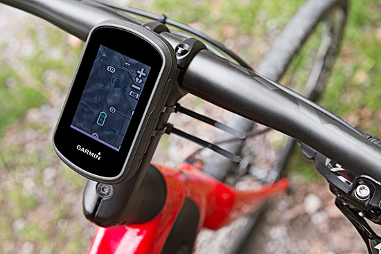
The Garmin eTrex can be mounted on bicycles, boats, ATVs or in the car.
Garmin International this summer is releasing the eTrex Touch 25, 35 and 35t, adding new touchscreen models to its line of outdoor handhelds.
The eTrex Touch series has a completely updated user interface, improving the ease-of-use of the device, as well as a 2.6-inch capacitive touchscreen display, the largest display that’s ever been put on an eTrex device. The eTrex Touch series also features new activity profiles for easy-to-use navigation for multiple activities and an enhanced track manager to easily start and stop recording.
The new eTrex Touch series has a high-sensitivity, WAAS-enabled GPS receiver with GLONASS support and HotFix satellite prediction to locate users’ position quickly and precisely, even in heavy cover and deep canyons.All units in the eTrex Touch series have a built-in 3-axis tilt-compensated electronic compass, which gives directional information even when standing still. The eTrex 35 and 35t also have a barometric altimeter to get more accurate altitude, elevation and climb information, as well as indications of pending weather changes.
The eTrex Touch 25, 35 and 35t are compatible with an array of mounts that are easy to use on bicycles, boats, ATVs or in the car, and offer a long-lasting 16-hour battery life, and a rugged ergonomic design to withstand the elements.
The eTrex Touch series integrates a variety of new activity profiles. The device remembers how each profile is set up to each activity, and will set it up for users the same way every time, making it comfortable, quick and intuitive to use the same device for entirely different purposes. No matter if users are out rock climbing, hiking, hunting, cycling, geocaching or fishing, with an eTrex Touch, switching between activities is easier than ever, even if they’re done all in one afternoon.
The eTrex Touch series comes preloaded with a worldwide shaded relief basemap, 4 GB of internal memory on the 25 and 35 models and 8 GB of internal memory on the 35t. The eTrex 35t also comes preloaded with TOPO U.S. 100K. With the built-in microSD card slot, users can install even more maps, like HuntView to see public and private land data while hunting, BirdsEye Satellite Imagery or TOPO U.S. 24K. All models come preloaded with 250,000 geocaches from Geocaching.com, so right out of the box users can start their geocaching adventure virtually anywhere in the world.
The eTrex 35 and 35t incorporate wireless ANT+ connectivity to accessory sensors like heart rate monitors, the Tempe temperature sensor, Chirp geocaching beacon, or the cycling speed sensors and cadence sensors. The eTrex 35 and 35t can also act as a wireless remote control for the VIRB line of action cameras. The eTrex 35 and 35t can connect via Bluetooth to compatible smartphones to receive smart notifications and stay connected out on the trail, but keep their phone safely packed away from the elements. Additionally, these units are compatible with the the Garmin Connect mobile app, for features such as LiveTrack. With LiveTrack, users can pair their device with the app, and invite friends and family to follow their activity in real time. This provides peace of mind, especially if users are alone.
The eTrex Touch 25 will have a suggested retail price of $249.99, the eTrex Touch 35 will have a suggested retail price of $299.99 and the eTrex Touch 35t will have a suggested retail price of $349.99.
A new book published by Esri covers the fundamentals of making digital maps, analyzing geospatial data, and building and editing spatial databases using ArcGIS. The workbook Getting to Know ArcGIS, fourth edition, is updated for use with the latest version of Esri’s ArcGIS for Desktop software.
Getting to Know ArcGIS teaches geographic information system (GIS) concepts and common tasks such as how to find GIS data online, create a web map, set map projections, symbolize and label maps, edit data, and geocode addresses.
The workbook also provides a preview of the new ArcGIS for Desktop ArcGIS Pro application. ArcGIS Pro is a new application for quickly creating and working with spatial data on your desktop. It includes scientific tools for spatial analysis, along with the capabilities needed to create and publish 2D and 3D content and to share maps in ArcGIS Online or on an internal server portal.
The workbook, which provides a comprehensive understanding of all the tools and functionality available in ArcGIS 10.3.1 for Desktop, can be used in classroom settings or for on-the-job training. The data for working through the exercises and a 180-day free trial of ArcGIS are available for download at Esri’s Book Resources website at esripress.esri.com/bookresources.
Getting to Know ArcGIS was written by Michael Law and Amy Collins. Law is a cartographer with more than 10 years of professional GIS experience. He has worked for Rand McNally Canada and for Esri, where he developed cartography for books and edited and tested GIS workbooks. Collins is a writer and editor who has worked with GIS for 13 years. She is a former technical editor at Esri, where she honed her knowledge of GIS and designed instructional materials for budding GIS professionals.
Getting to Know ArcGIS is available in print (ISBN: 9781589483828, 808 pages, US$84.99) or as an e-book (ISBN: 9781589484283, US$64.99). The book is available at online retailers worldwide, at esri.com/esripress, or by calling 1-800-447-9778. If outside the United States, visit esri.com/esripressorders for ordering options, or visit esri.com/distributors to contact your local Esri distributor.
From our July issue comes this showcase featuring products for surveyors, geographic information systems (GIS) professionals, field workers, and anyone who is looking to expand the capabilities of their smartphone or tablet.
Dedicated Survey/Geospatial
Three-Accuracy Series
The LT500 series of handheld GPS receivers, LT500H/T/N, covers three accuracy ranges from sub-meter to centimeter. It is a cost-effective full GNSS positioning solution for survey, construction and GIS professionals.
Powered by the Windows Embedded Handheld 6.5 operating system, the LT500 is accurate, rugged and versatile. User productivity is enhanced with the built-in gyroscope, an innovative laser plummet for positioning the accurate handheld receiver over a point, an E-compass for showing the direction and G-sensors for leveling. The LT500 series comes bundled with software including SurvCE, DigiTerra and MapCloud. The LT500H has120 channels (GPS L1/L2/L2C, GLONASS G1, G2, BeiDou B1 and Galileo E1), the LT500T has 220 channels (L1, G1, B1), and the LT500N has 12 channels (L1).
The all-in-one TRIUMPH-LS by JAVAD GNSS combines a high-performance 864-channel GNSS receiver, all-frequency GNSS antenna, and a modern featured handheld. The 864 all-in-view channels include Galileo E1/E5A/E5B, GPS L1/L2/L5, GLONASS L1/L2/L3, QZSS L1/L2/L5, BeiDou B1/B2 and SBAS L1/L5.
More than 100 channels are dedicated to continuous interference monitoring, allowing safe GNSS operation in a city, airport and military environment.
The GEOmeter MX system is designed to gather GIS information in heavily wooded areas, with object description, area coordinates and measurement time grasped automatically. The system consists of the GEOsat MXbox receiver, a combination antenna, a PDA such as the Trimble Recon or the Handheld Nautiz X8, and GEOfield software for mobile GIS.
The Mxbox receiver is a Hemisphere multi-constellation GNSS OEM board with GPS, GLONASS, BeiDou, Galileo and QZSS, plus code- and carrier-phase tracking for increased positioning accuracy and availability. The GEOfield software offers reliabe recording, representation and processing of geodata. Measurement quality is indicated in the field with statistics and graphics, in either German or English.
The Matchstiq S10 is a software-defined radio (SDR) platform. It provides increased RF flexibility, RF performance and signal processing capacity in a small package. The Matchstiq S10 platform combines the Epiq Solutions’ Sidekiq SDR with a quad-core processor system running Linux. The Sidekiq MiniPCIe SDR card provides an independently tunable RF transmitter and receiver covering 70 Mhz to 6 Ghz with an RF bandwidth up to 50 Mhz, plus FPGA. The Matchstiq S10 platform also integrates GPS, Gigabit ethernet (with PoE), USB 2.0 OTG, HDMI and real-time clock in a very small form factor package.
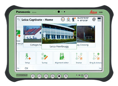
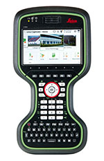
Leica Captivate software provides a 3D view for the Leica Viva GNSS, merging the overlay of measured points, 3D models and point clouds into a single view.
Using Leica Captivate, users can capture and manage complex data with the touchscreen on both the Leica CS20 handheld controller and the CS35 tablet.
The CS20 runs on Windows EC7 and is IP68 and MIL-STD-810F rated. It has a 5-inch WVGA color touchscreen that allows for comfortable and quick data processing and a fully integrated radio and antenna for long range robotic total station control. The CS35’s 10.1-inch screen is visible in all conditions. It runs on Windows 8.1 Pro, enabling workers to take their office into the field. It is IP65 and MIL-STD-810G rated.
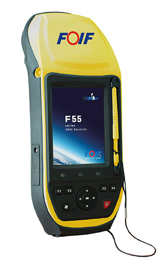
The FOIF F55 series GIS handheld comes in two models: F55-A and F55-B. The onboard software FOIF SuperGiS allows users to conduct field mapping with powerful functions for data collecting, data editing and data querying.
The F55 measures 234 x 99 x 56 mm and weighs 895 grams. It has an IP65 rating for water and dust protection. The F55-A supports four GNSS (GPS, GLONASS, Galileo and Beidou) as well as SBAS, and can search for up to 120 channels. The F55-B supports GPS and SBAS and provides 12 channels.
With Differential GPS, the F55-A has an accuracy of 0.4 meters, and the F55-B has an accuracy of 0.5 meters. RTK surveying on the F55-A obtains high precision of 1 cm + 1 ppm. Real-time correction service and post-processing are available.
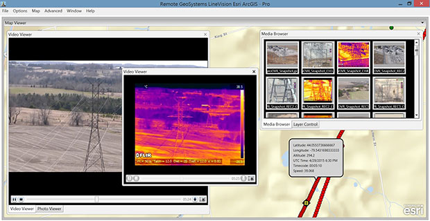
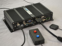
The geoDVR Gen2 is an advanced multi-channel high-definition/standard-definition geospatial digital video recorder designed for aerial and mobile environments.
Unlike a DVR, the rugged geoDVR permanently embeds videos with important GPS location, time and other data — the GPS metadata remains intact even when a video is edited. Most video cameras and gyro-stabilized gimbals can be connected to the geoDVR for recording of HD or geospatial video files.
Video files created by the geoDVR can be analyzed in the RemoteGeo LineVision suite of mapping applications, including tools for Google Earth, Esri ArcGIS, PLS-CADD and the LineVision Cloud. The administrative dashboard allows for monitoring up to four video streams in real-time.
The G1-m1 receiver is part of the G1 family of products from Geomatics USA. The G1 system is scalable from a single-frequency semi-mobile receiver — for control networks and some semi-kinematic mapping applications — to a dual-frequency network RTK solution. It was designed to be lightweight, accurate and portable, especially suited to building a system for travel; for example, all the G1-m1 components, including tripod, will easily pack into a baseball-style bag for transport. The G1-m1 offers centimeter and sub-foot accuracy (centimeter-level accuracy is possible for OPUS-compliant static sessions).
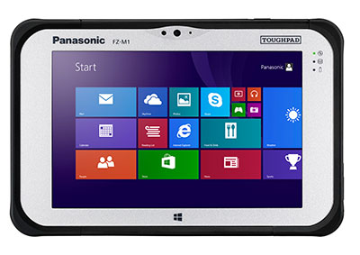
The Panasonic Toughpad FZ-M1 is a thin, light and rugged 7-inch Windows tablet with dedicated GPS — the u-blox Neo M8 series — as an option. The FZ-M1 is built to enable mission-critical mobile worker productivity. Powered by Windows 8.1 Pro and a choice of two Intel processors, it features a long life, user-replaceable battery and a daylight-readable, high-sensitivity multi touchscreen for use with heavy gloves. With a broad range of configuration options, the customizable Toughpad FZ-M1 is rated MIL-STD-810G and IP65, resistant to five-foot drops, weather, dust and water.
Trimble’s RTX technology-based correction services — Trimble CenterPoint RTX, Trimble RangePoint RTX and the new Trimble ViewPoint RTX — are now available on Trimble Geo 7X handhelds.
Trimble RTX technology provides compatible GNSS receivers with correction services that significantly improve accuracy and reliability in obtaining positions worldwide. Operational efficiency and productivity in the field is improved by delivering real-time DGNSS corrections directly to the Trimble Geo 7X handheld.
The handheld solution is designed for industries such as utility companies, municipalities and environmental management agencies, in which workers are highly mobile and require a reliable, flexible data-collection and asset management solution.
A choice of RTX correction services ranging from 4 centimeters to submeter-level horizontal accuracies is available.
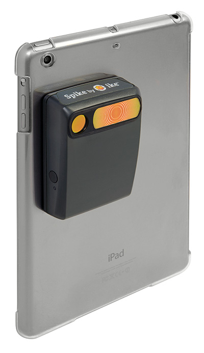
The Spike device and Spike mobile app allow users to measure an object by capturing a photo from a smartphone or tablet. From the photo, users can capture real-time measurements, including height, width, area, length and target location. Location data includes latitude, longitude and altitude. Spike is useful for construction, inspection, safety, advertising, real estate, insurance and government applications.
Measurements and location data are saved with the picture and can be shared via email as a PDF, XML and KMZ. KMZ files can be imported into GIS tools such as ArcGIS and Google Earth. The photo can be referenced via the Spike app to take new measurements or view original measurements.
The Spike device pairs with an Android or Apple iOS smartphone or tablet via Bluetooth. Its laser rangefinder works with a smartphone’s camera, GPS, compass and Internet connection.
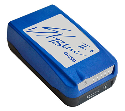
The iSXBlue II+ GNSS is a palm-sized receiver that delivers real-time, high-accuracy performance using GPS+GLONASS satellites and free SBAS corrections for an iPad or iPhone. Its battery-powered lightweight design is for a variety of mapping applications including GIS, forestry, mining, utilities, agriculture, surveying and environmental. It delivers high accuracy in real time without the need for post-processing or another correction source when SBAS (WAAS, EGNOS, MSAS or GAGAN) are available. Using both GPS and GLONASS satellites, the iSXBlue II+ GNSS will work where GPS receivers struggle, such as in the forest, around buildings and in other difficult mapping environments. The L1/G1, GPS+GLONASS receiver has 372 channels.
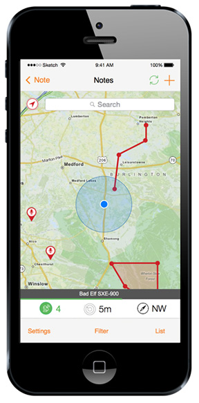
TerraGo Edge allows organizations to collect data and share field information on their smartphones and tablets. TerraGo Edge replaces traditional GPS handheld devices with a mobile cloud-based solution. Users can collect GPS data points at any accuracy level, either by using the onboard GPS on a smartphone or by attaching a centimeter-level GPS receiver to a mobile device.
TerraGo Edge 3.6 features enhanced support for high-accuracy GPS receivers such as EOS and SXBlue on both iOS and Android, as well as better mapping features, basemap sources and integration with Google Earth.
For managers, TerraGo Edge provides a real-time dashboard for monitoring field users and data collection.
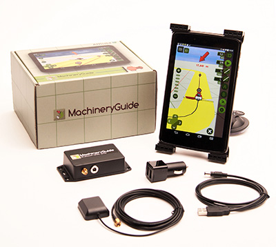
MachineryGuide enables a tablet or smartphone to be used as a precision tractor GPS system. The MachineryGuide Android guidance program functions as a precision farming application using an antenna capable of receiving and processing EGNOS and WAAS corrections. It can be used for any farming activity that is done by tractor or other agricultural machinery, including fertilization, manure application and spraying. It even can be used for land measurements.
MachineryGuide sells the software separately; a GNSS receiver + antenna separately; and a package bundle that includes software, GNSS receiver and antenna. The receiver uses GPS, GLONASS, SBAS and QZSS signals for a position accuracy of 2.5 meters CEP.
The TomTom Bandit Action Camera allows creation of videos within moments of the action. It comes with a built-in media server, eliminating the need to download footage before editing. The camera works with a companion app, making it possible to create and share videos in a matter of minutes — by shaking a smartphone.
The TomTom Bandit Action Camera is equipped with in-camera motion and GPS sensors to automatically find and tag footage based on speed, altitude, G-force, acceleration and heart rate. Highlights can also be tagged manually with a tagging button on the camera or the remote control.
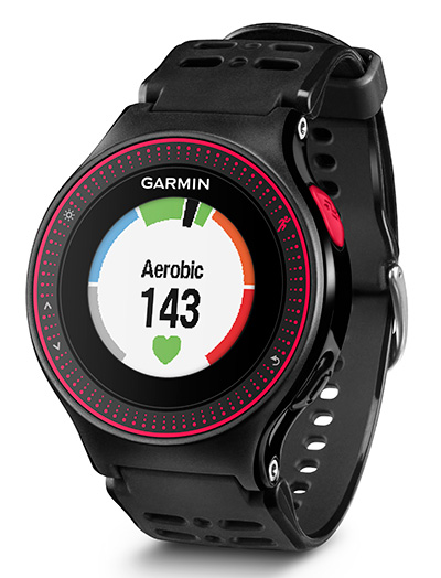
The Forerunner 225 integrates optical heart-rate technology by Mio and features a colorful graphic interface showing runners their zone and beats per minute at a glance. A built-in accelerometer provides distance and pace data for indoor running with no need for a separate foot pod. To keep runners active between workouts, it doubles as an activity tracker, counting steps, calories and distance.
When paired with a compatible smartphone, the Forerunner 225 will automatically upload a completed run to the Garmin Connect Mobile app for post-run analysis and sharing on social media sites. Runners can also use live tracking to allow friends and family to follow along during training or on race day to see stats in real time.
Satel presents the tiny UHF radio data transceiver module Satelline TR4.
The new Satelline TR4 from Satel, a Finnish manufacturer of radio data transmission systems, is a compact UHF transceiver with transmitting power of 1,000 mW. The transceiver is compatible with the protocols of Pacific Crest, Trimble and Satel.
The type certifications in important regions of the world make the TR4 ideal for integration in end devices intended for international use. With a weight of only 18 g, transmitting power of 1,000 mW and an “over the air” data transmission rate of 38,400 bps, it fulfills all present-day standards, Satel said.
The tiny UHF transceiver is designed for easy integration, with dimensions of 56 x 36 x 6 millimeters, Satel said. Robust UHF frequencies (400-470 MHz) are a reliable basis for the communication of self-sufficient stations even in the event of unknown topology. In addition, the new TR4 features the advantages of the Satelline EASy and 3AS modems, including channel scanning, error correction and compatibility with protocols of Pacific Crest, Trimble and, of course, Satel.
Since license-free frequencies are becoming more popular, such as 869 MHz in Europe and 915 MHz for the American market, transceiver modules of identical design will follow. The identical footprint and the standardized communication commands will minimize integration costs. Later it will only be necessary to insert the corresponding radio module for the destination and the end device will be ready to use.
In Germany, radio data transmission solutions from Satel are distributed exclusively by the full-range and systems provider Welotec. At INTERGEO in Stuttgart, September 15 – 17, the partners will present their products at adjacent stands: Satel and Welotec will be in Hall 4 – Booth G4.020.
High-performance digital camera maker Point Grey has added a new 12 MP CCD model to its Grasshopper3 USB3 Vision camera line. With high-resolution CCD image quality, high-dynamic range, and USB 3.0 interface, the Grasshopper3 is suited for a variety of demanding applications including industrial inspection, 3D scanning, microscopy and mobile mapping.
The Grasshopper3 GS3-U3-120S6 models are based on color and monochrome versions of the 1-inch Sony ICX834 global shutter CCD sensor, which features 3.1 micron pixels and 4242 x 2830 image resolution running in dual-tap at 7 FPS. The ICX834 device uses Sony’s EXview HAD CCD II pixel architecture with improved quantum efficiency and near infrared response (NIR).
EXview HAD CCD II also enables smaller pixel sizes while maintaining excellent imaging performance. This allows the high-resolution ICX834, with its 1-inch optical format, to be integrated into compact C-mount cameras like the Grasshopper3, and used with smaller, lower cost C-mount lenses.
Grasshopper3 Like all Point Grey USB 3.0 cameras, the Grasshopper3 uses a proprietary USB 3.0 link layer and frame buffer-based architecture for optimal performance and reliability. The Grasshopper3 uses an advanced image processing pipeline to enable color interpolation, look up table, gamma correction, pixel binning and USB3 Vision support.
“We’re excited to continue expanding our Grasshopper3 USB3 Vision family with even higher resolution sensors,” says Michael Gibbons, Director of Sales and Marketing at Point Grey. “This new 12 MP Grasshopper3 camera is Point Grey’s highest resolution machine vision camera to date. The ultra HD 4K Sony ICX834 CCD sensor achieves a higher sensitivity in the near infrared range (NIR) and offers better price performance than other high resolution cameras on the market.”
The Grasshopper3 GS3-U3-120S6 is list priced at $3695/€2795 and is available to order now from Point Grey, its network of distributors and the online store (for North American, EU and Australian customers).