Tag: product showcase

  • TomTom’s New Devices Have Lifetime Maps, Speed Cameras

    TomTom’s New Devices Have Lifetime Maps, Speed Cameras

    TomTom is introducing Lifetime World Maps and Lifetime Speed Cameras to drivers with the launch of four new TomTom navigation devices.
    TomTom is introducing Lifetime World Maps and Lifetime Speed Cameras to drivers with the launch of four new TomTom navigation devices.

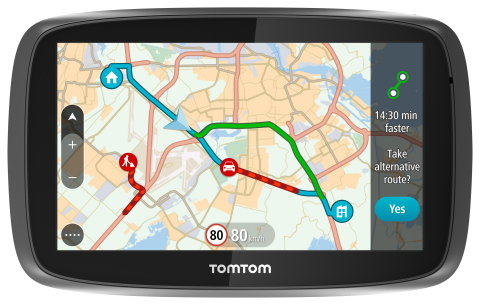
    TomTom is introducing Lifetime World Maps and Lifetime Speed Cameras to drivers with the launch of new TomTom navigation devices. Lifetime World Maps allow people to drive with maps from around the world at no extra cost, for the lifetime of their TomTom GO device2. Lifetime Speed Cameras let drivers know the locations of all speed cameras — both fixed and mobile, also for the lifetime of the device.

    The TomTom GO 510, 610, 5100 and 6100 feature a fully interactive screen to pinch, zoom and swipe — as well as a rich user interface, simplified user interaction, 3D Maps and a Click & Go mount. Drivers can also choose between a 5-inch or a 6-inch screen size, TomTom said. The new TomTom GO devices also include “Drive Home” and “Drive to Work” buttons in the main menu, for faster, simpler navigation.

    TomTom GO devices combine real-time traffic information with routing technology, to always offer drivers the fastest route available. TomTom Traffic covers all mapped roads and combines data from millions of data sources, from all over the world, to deliver traffic information so accurate that, with each new update, it can pinpoint the start and end of a traffic jam, precisely, down to 10 meters.

    “With the addition of Lifetime World Maps and Lifetime Speed Cameras to our new TomTom GO devices, we’re offering the most comprehensive package to drivers that we’ve ever launched,” said Corinne Vigreux, co-founder and managing director, TomTom Consumer. “Our aim is to help you avoid the jams, getting to your destination faster, wherever in the world you might be.”

    Lifetime TomTom Traffic is available via a smartphone connection on the TomTom GO 510 and 610. The TomTom GO 5100 and 6100 offer Lifetime TomTom Traffic via a built-in SIM with unlimited data and roaming at no extra cost.

    The new TomTom navigation devices are compatible with TomTom MyDrive4. For the first time, drivers can use their smartphone, tablet or PC to review real-time traffic information, plan routes, and send destinations to their TomTom GO, before they get in the car. Previously launched TomTom GO devices5 are also compatible with MyDrive though a simple software update. Find out more about TomTom MyDrive here.

    The new TomTom GO devices are now available online and in-store from €199.95.

  • CHC Offers LT500 Series Handheld for GIS

    The CHC LT500.
    The CHC LT500.

    CHC has launched the LT500 series of handheld GPS receivers. The LT500 series LT500N /LT500T/LT500H covers three accuracy ranges from sub-meter to centimeter accuracy and is a cost-effective full GNSS positioning solution for survey, construction and GIS professionals.

    Powered by the Windows Embedded Handheld 6.5 operating system, the LT500 is accurate, rugged and versatile, CHC said. User productivity is enhanced with the built-in gyroscope, an innovative laser plummet for positioning the accurate handheld receiver over a point, an E-compass for showing the direction and G-sensors for leveling.

    The LT500 series is competitively priced and comes with several bundled software programs, including SurvCE, DigiTerra, MapCloud and other third-party software.

    “CHC’s LT500 series is our brand-new GNSS handheld, which has amazing features and specifications. It meets more customers’ needs with more options and affordable prices,” said George Zhao, CEO of CHC. “The introduction of the LT500 demonstrates CHC’s commitment to provide the GIS community with a full spectrum of rugged, cost-effective professional GPS handhelds.”

    The LT500 series features these specifications:

    • 1-GHz high-speed CPU with 512-MB RAM and 16-GB flash memory built-in
    • Three tracking options:
      • LT500H 120 channel GPS L1/L2/L2C,GLONASS G1,G2,BeiDou B1, Galileo E1 Tracking
      • LT500T 220 channel L1,G1,B1
      • LT500N 12 channel L1
    • 13-hour battery: 11.1V, 2600mAh
    • Gyro, laser-plummet, E-compass, G-sensor

    The LT500 series is available immediately through CHC’s worldwide distribution channel.

  • CHC Introduces LT500 Series GNSS Handheld

    CHC Introduces LT500 Series GNSS Handheld

    Photo: CHC

    CHC has launched the LT500 series of handheld GPS receivers. The LT500 series LT500N /LT500T/LT500H covers three accuracy ranges from sub-meter to centimeter accuracy and is a cost-effective full GNSS positioning solution for survey, construction and GIS professionals.

    Powered by the Windows Embedded Handheld 6.5 operating system, the LT500 is accurate, rugged and versatile, CHC said. User productivity is enhanced with the built-in gyroscope, an innovative laser plummet for positioning the accurate handheld receiver over a point, an E-compass for showing the direction and G-sensors for leveling.

    The LT500 series is competitively priced and comes with several bundled software programs, including SurvCE, DigiTerra, MapCloud and other third-party software.

    “CHC’s LT500 series is our brand-new GNSS handheld, which has amazing features and specifications. It meets more customers’ needs with more options and affordable prices,” said George Zhao, CEO of CHC. “The introduction of the LT500 demonstrates CHC’s commitment to provide the GIS community with a full spectrum of rugged, cost-effective professional GPS handhelds.”

    The CHC LT500.
    The CHC LT500.

    The LT500 series features these specifications:

    • 1-GHz high-speed CPU with 512-MB RAM and 16-GB flash memory built-in
    • Three tracking options:
      • LT500H 120 channel GPS L1/L2/L2C,GLONASS G1,G2,BeiDou B1, Galileo E1 Tracking
      • LT500T 220 channel L1,G1,B1
      • LT500N 12 channel L1
    • 13-hour battery: 11.1V, 2600mAh
    • Gyro, laser-plummet, E-compass, G-sensor

    The LT500 series is available immediately through CHC’s worldwide distribution channel.

  • Schweitzer Labs Adds PTP Support to Network Clock

    Schweitzer Labs Adds PTP Support to Network Clock

    Graphic: Schweitzer Labs

    Schweitzer Engineering Laboratories, Inc. (SEL) has added support for the Precision Time Protocol (PTP) to its SEL-2488 Satellite-Synchronized Network Clock. In a single clock, users can now synchronize end devices with sub-microsecond accuracy using demodulated IRIG-B and/or PTP. The SEL-2488 can meet all the timing needs of industrial and utility applications.

    The SEL-2488 offers security features, including Satellite Signal Verification in which the clock uses two satellite constellations to validate time signals, providing a layer of protection from GPS spoofing attacks. For fault tolerance, customers can opt for a second, redundant hot-swappable power supply, which can be connected to a second power input source. If GPS is lost, the clock switches to a standard TCXO holdover with 36-microsecond-per-day accuracy or an optional OCXO holdover with 5 microsecond average accuracy. The clock operates over a wide temperature range of –40° to +85°C (–40° to +185°F) and is backed by SEL’s 10-year, no-questions-asked worldwide warranty.

    In addition to providing IRIG-B and NTP outputs, the SEL-2488 can now serve as a PTP grandmaster clock, supporting both the default profile (IEEE 1588-2008) and the power system profile (IEEE C37.238). The SEL-2488 is capable of synchronizing time for up to four independent networks with a time-stamp accuracy of 100 nanoseconds. Existing users of the SEL-2488 can purchase this as a firmware upgrade.

    “Now there’s a choice,” said Shankar Achanta, R&D manager for precise time and wireless networks at SEL. “You can use different timing protocols based on your infrastructure and application needs. The SEL-2488 is the one network clock that can meet all our customers’ timing needs.”

    The SEL-2488 was first released in September 2014. SEL included several security features such as Syslog, the Ethernet standard for event messaging, which allows the SEL-2488 to integrate smoothly into a customer’s existing event system; role-based accounts and Lightweight Directory Access Protocol (LDAP) for user authentication; and a secure HTTPS web interface, which provides a graphical SkyView display for troubleshooting signal or antenna issues. The SEL-2488 also meets and exceeds IEEE 1613 Class 1, an electric transient and interference standard for communications products.

    Designed, tested and manufactured in Pullman, Wash., a standard SEL-2488 configuration, including a dual-constellation, high-gain GNSS antenna, retails for $2,700. The PTP firmware upgrade option for existing users costs $1,750. To learn more about the PTP enhancement in the SEL-2488, visit www.selinc.com/p222.

  • Trimble Expands Geospatial Portfolio to Increase Productivity


    Trimble-S9-Total-Station-Application-W

    Trimble has expanded its portfolio of geospatial solutions for surveyors, engineers and mapping professionals. Highlights include new total stations, a new GNSS receiver and new field and office software features. The solutions save time, reduce costs, streamline workflows and produce high-quality geospatial deliverables across a wide range of industries, Trimble said.

    “Trimble’s portfolio expansion will enable our customers to work in a more efficient, seamless and collaborative manner,” said Chris Gibson, vice president of Trimble. “Trimble’s solutions are best known for quality, dependability and performance. Our vision is to equip customers with the most innovative tools, which includes a focus on offering new software applications that streamline and elevate the value of geospatial data to guide smart decision-making and transform the way organizations work.”

    The expanded portfolio of productivity solutions include:

    Total Station Solutions

    Trimble-totalstations-W

    A range of new and enhanced robotic total stations — the Trimble S5, S7 and S9 — improve project efficiencies, productivity and deliverables. Times saving enhancements include improved Trimble VISION technology, SureScan technology included in the S7 and optional in the S9 total station, and the DR Plus electronic distance measurement technology as a standard feature.

    Theft and loss risks are also minimized now with Locate2Protect technology embedded in each instrument, allowing users to remotely track the location of their equipment in real-time using Trimble InSphere Equipment Manager.

    In the office, Trimble Business Center software can be used to create high-dynamic-range (HDR) images using data captured with total stations. A new total station data editor enables fieldwork to be rapidly reviewed and allows surveyors to create deliverables with confidence, Trimble said.

    Scanning Solutions

    Trimble continues to blend powerful 3D laser scanning and imaging hardware with workflow-based software to drive new efficiencies for survey applications and construction planning and design.

    The Trimble TX8 3D laser scanner now offers greater accuracy (down to 1 mm) and streamlined onboard operation when measuring to longer ranges, decreasing the field time required for capturing reliable high-accuracy data.

    Enhanced tools in Trimble RealWorks software version 9.1 further reduce the time to produce high-quality deliverables from Trimble TX8 data. The new version of Trimble RealWorks software includes improved workflows for creating floor settlement plans and 3D pipeline models as well as complete storage tank inspection and reporting capabilities.

    GNSS Solutions

    The new Trimble R8s Integrated GNSS receiver and updated version of Trimble Access field software combine to offer configurable and scalable settings. Surveyors have the flexibility across their workflows by being able to tailor the Trimble R8s receiver with the updated field software for their specific application. The ability to customize provides flexibility for future business requirements and allows customers to maximize efficiencies across their workflows.

    cameraSightImage_S6-W

    Imaging Solutions

    Trimble enhancements to Trimble VISION workflows increase the value of highly accurate image data. Survey, engineering and civil infrastructure professionals can now generate dense point cloud deliverables in Trimble Business Center from images captured using the Trimble V10 Imaging Rover. Users can also quickly generate 2D CAD and 3D real-world models from images captured with Trimble total stations using the streamlined workflows created within Trimble Business Center and SketchUp software.

    Availability

    Trimble Access field software, Trimble Business Center version 3.50 office software, the Trimble R8s GNSS receiver, Trimble S5, S7 and S9 Total Stations and TX8 3D Scanner are available now through Trimble’s Geospatial Distribution Channel.

  • Exelis Launches Surveillance Tool for UAV Operators

    With Exelis RangeVue, a high-performance GIS visualization engine provides real-time updates of critical operational elements.
    With Exelis RangeVue, a high-performance GIS visualization engine provides real-time updates of critical operational elements.

    Exelis has launched its first airspace situational awareness tool designed specifically for unmanned aerial system (UAS) operations in the United States. Symphony RangeVue puts real-time Federal Aviation Administration (FAA) surveillance data, flexible background maps and weather information in the hands of UAS operators and test range personnel. The system provides significant improvements to the safety and efficiency of UAS operations, whether on the test range or in the field.

    Symphony RangeVue enables UAS operators and test range personnel to have access to both real-time and historical surveillance information via a web-hosted platform, helping to manage mission operations from multiple locations with full visibility of assets. Symphony RangeVue can be used as a command center decision-support and post-event analysis tool, or in the field as a sense-and-avoid addition to UAS ground control stations. Flexible geo-fencing tools alert operators when a UAS approaches airspace boundaries or when other aircraft are in the vicinity.

    “For the first time, UAS operators and test range personnel will have the same situational awareness currently available to general aviation pilots through traffic information broadcast services. This capability is available without having to install avionics surveillance equipment on the UAS aircraft,” said Ed Sayadian, vice president of Civil and Aerospace Solutions for Exelis. “Leveraging the FAA’s own surveillance data combined with advanced sense-and-avoid alerting capabilities, Symphony RangeVue will significantly increase the safety of UAS operations.”

    Symphony RangeVue combines a high-performance visualization engine with the vast network of Exelis NextGen surveillance data, including all of the FAA’s surveillance systems: automatic dependent surveillance-broadcast; en route radar; terminal radar; airport surface detection equipment-X; airport surface surveillance capability; and wide area multilateration. It also integrates locally deployed surveillance assets to deliver hyperlocal situational awareness.

  • GIS Cloud Previewing Collaborative App Maplim

    GISCafe-Maplin

    GIS Cloud is previewing Maplim, an application that allows for fast, intuitive real-time collaboration on a map using any device. GIS Cloud is offering sign-ups for free, early access to Maplim.

    According to GIS Cloud, “The idea is to put a map in the context of an organization board where you created projects and cards while engaging with your colleagues in discussions, making drawings (redlining and annotations), attaching documents, or just leaving comments.

    Features:

    • Organization. Create real-time collaboration streams as cards, to which you can add any content around a map and share it with your colleagues. Maplim adapts to your project, team, and workflow.
    • Redline and Comment. Seamlessly make drawings on a map, add notes, marks, and comments, and provide your team with everything they need to get things done in real time.
    • Sharing. Attach and access important media such as photos, videos, PDFs, and Excel and Word documents relevant to a card.
    • Sync. Maplim stays perfectly in sync across all your devices, wherever you are. Post comments for instant feedback, follow your team’s activity in real time, and share results with anyone, anywhere, and on any device.

    GIS Cloud is offering a free webinar on Maplim on April 28.

  • Esri Book Explores Spatial Thinking, Research Using GIS

    GIS Research Methods provides a solid introduction to research methods using GIS.
    GIS Research Methods provides a solid introduction to research methods using GIS.

    Scientific data that’s spatially analyzed produces highly useful information for academics, scientists and other researchers, helping them answer questions and make well-informed decisions, according to a new book published by Esri.

    The book GIS Research Methods: Incorporating Spatial Perspectives shows how spatial analysis using geographic information system (GIS) technology enhances research in the social and physical sciences.

    Authors Sheila Lakshmi Steinberg and Steven J. Steinberg explain how to incorporate spatial thinking and GIS into research design and analysis. The book introduces readers to the value of thinking spatially, GIS basics, research design and ethics, data sampling and collection, volunteered geographic information, spatial analysis with Esri ArcGIS technology, and more. The authors are scientific researchers who have used GIS in their academic work.

    “A unique aspect of this book is that we focus specifically on how to integrate GIS into both qualitative and quantitative research,” the Steinberg’s wrote in the book’s foreword. “Our objective in writing this book is to provide a foundation for GIS research methods and, more specifically, to integrate spatial thinking and spatial analysis into a research tool with clear methodological techniques.”

    The book, which was written for social and physical science professionals and academics, provides an introduction to research methods using GIS. For example, readers will learn how to develop useful, spatial information-based interviews and surveys for collecting data in the field; select the right tools for spatial analysis; visualize spatial information; and communicate the results of analyses, Esri said.

    The book also outlines what to consider — for example, geographic boundaries, the data, and a diverse group of stakeholders—when creating strong place-based policies. “Policy makers who consider space and place will be more likely to generate policy that is effective in the long run because it has a better opportunity to consider the concerns, needs, and perspectives that tie to data, people, and place,” said the Steinberg’s.

    Sheila Lakshmi Steinberg is a professor of social sciences at Brandman University, based in Irvine, Calif. She earned her bachelor’s degree from the University of California, Santa Barbara; her master of science degree from the University of California, Berkeley; and her doctorate from Pennsylvania State University. Her research interests include environmental sociology, culture and GIS.

    Steven J. Steinberg is a principal scientist at the Southern California Coastal Water Research Project, a public environmental research agency based in Costa Mesa. He received his Bachelor of Science degree from Kent State University, his Master of Science degree from the University of Michigan and his doctorate from the University of Minnesota.

    GIS Research Methods: Incorporating Spatial Perspectives is available in print (ISBN: 9781589483781, 440 pages, US$79.99) or as an e-book (ISBN: 9781589484047, 440 pages, US$79.99). The book is also available at online retailers worldwide, at esri.com/esripress, or by calling 1-800-447-9778. Outside the United States, visit esri.com/esripressorders for complete ordering options, or visit esri.com/distributors to contact your local Esri distributor.

  • Antenova M2M Showcases Brevis GNSS Tracking Antenna

    Antenova M2M Showcases Brevis GNSS Tracking Antenna

    Antenova Brevis
    Antenova Brevis antenna is tiny at 11mm x 6mm.

    The Brevis GNSS antenna is the latest addition to Antenova’s gigaNOVA family of miniature antennas. The small antenna is designed to be used in portable handheld devices that have GNSS receivers — for example, in devices and applications that have a tracking capability or location accessories such as in transport, navigation, wearables and eHealth.

    The multi-GNSS antenna is designed for embedded applications, with a high efficiency-to-size ratio. It is intended for use in applications where there is no ground beneath the antenna. It has near omni-directional characteristics which will provide good performance for any device.

    The Brevis operates with the following GNSS bands: GPS, GLONASS, Galileo and BeiDou. Brevis GNSS is a low-profile, small-footprint antenna designed for surface-mount device (SMD) mounting, so it can simply be placed on a printed circuit board (PCB) to add wireless connections to any device.

    Full technical specifications for the Brevis GNSS antenna and contact details for regional distributors are available on Antenova’s website.

  • Topcon Offers Total Station with Enhanced Reflectorless Range

    GPT-3500_Field_Topcon-W Topcon Positioning Group has added to its line of reflectorless total stations for the construction and mining market. The GPT-3500LNW total station has a measuring distance of 2,000 meters (6,560 ft.). It is designed to measure further than any non-prism instrument in its class. “Incorporating the Topcon advanced time-of-flight pulse technology, the EDM is fast and powerful,” said Ray Kerwin, director of global surveying products. “The Topcon algorithm filters signal noise to provide accurate measurements even on dark and wet surfaces, where other reflectorless technology might fail.”

    The Topcon GPS-3500 total station.
    The Topcon GPS-3500 total station.

    Along with its onboard data collector, the GPT-3500 can connect to an external field controller via built-in Bluetooth technology, enabling field to office connectivity with the MAGNET suite of software solutions. The system can also be paired with a prism to allow for a measurement range of up to 3000 meters (9,842 ft.). Additional features include a rugged IP66 rated design, on-board TopField application software and battery life of up to five working hours.

  • Tallysman GNSS Antennas Optimized for Multi-Constellation Systems

    Tallysman’s compact GNSS TW1721 Dual Feed embedded antenna with Accutenna technology.
    Tallysman’s compact GNSS TW1721 dual-feed embedded antenna with Accutenna technology.

    Tallysman, a provider of high-performance, high-quality RF and GNSS components, has announced that its range of antennas featuring proprietary Accutenna technology is optimized for today’s multi-constellation satellite systems, including Europe’s Galileo, China’s next-generation BeiDou, GPS, GLONASS and India’s IRNSS.

    Tallysman’s compact GNSS antenna range with Accutenna technology is future-proof: GNSS is changing, and an increasing number of receivers are capable of accessing multiple constellations — GPS, GLONASS, Galileo, BeiDou — but to provide the high precision these new generation of satellites enable also requires new antenna technology.

    Tallysman’s proprietary Accutenna dual-feed patch technology used in the company’s wide range of GNSS antennas provides circular response over the entire antenna bandwidth, yielding superior multi-path signal rejection-low axial ratios, tight phase center variation (PCV), and a linear phase response. Single-feed patch antennas, by contrast, only provide a circular response at a single frequency and exhibit poor multipath signal rejection when receiving signals from two or more constellations. A pre-filtering option is available that gives additional protection from near out-of-band signals if required.

    “Today’s wideband GNSS signals require a pure right-hand-circular response over a much wider bandwidth,” said Gyles Panther, president of Tallysman.  “An inadequate phase response results in poor cross polarization suppression, which simply cannot be overcome in the GNSS receiver chip, regardless of its capabilities. Moreover, multipath interference can be expected, even in normal reception situations. Accutenna technology is a cost-effective way to ameliorate this and is particularly beneficial in situations where precision matters.”

    In March, the European Space Agency launched two additional satellites (Galileo 7 and 8). Also in March, the United States launched GPS IIF-9, India launched IRNSS-1D, and China successfully launched its new generation BeiDou-3 M1. The expanding number of satellites will benefit many applications, from next-generation in-car navigation systems to coastguard search and rescue and precision agriculture, Tallysman said.

  • Esri Offers Data Reviewer for Electric Utilities

    Data Reviewer for Electric Utilities provides more than 40 out-of-the-box checks that users can run individually, group into batch jobs (as .rbj files), or run as a scheduled service.
    Data Reviewer for Electric Utilities provides more than 40 out-of-the-box checks that users can run individually, group into batch jobs (as .rbj files), or run as a scheduled service.

    Esri has released a Data Reviewer for Electric Utilities. It provides the preconfigured ArcGIS Data Reviewer for Desktop to be used to validate, maintain and improve the integrity of electric distribution data.

    Data Reviewer for Electric Utilities provides a set of tools to simplify many aspects of automated and visual data quality control. The solution provides more than 40 out-of-the-box checks that users can run individually, group into batch jobs (as .rbj files), or run as a scheduled service.

    “As utilities continue to collect more information about their electric network, it’s imperative that this information be validated to ensure accuracy and completeness of the overall content,” Esri solutions team lead Patrick Dolan said. “The release of Data Reviewer for Electric Utilities allows utilities to automate the way they validate and measure the overall health of their electric distribution network, providing them with greater insurance that the electric network is accurate and complete.”

    Download the Data Reviewer for Electric Utilities solution for free, including a demonstration and sample electric dataset.

    Learn more about Esri solutions for utilities at esri.com/electric.