Tag: product showcase

  • Spectra Precision Offers Flexible GNSS Receiver for Surveyors

    Spectra Precision Offers Flexible GNSS Receiver for Surveyors

    Spectra Precision SP60.
    Spectra Precision SP60.

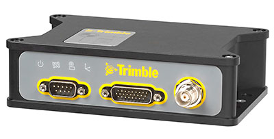
    Spectra Precision has introduced its new SP60 GNSS receiver. Designed to meet the evolving needs of surveyors, the SP60 is a versatile solution combining next generation Spectra Precision GNSS technology, a high level of configuration flexibility and an innovative design, the company said. The SP60 is part of Spectra Precision’s latest portfolio of GNSS receivers specifically designed for the mainstream survey and construction applications such as cadastral, topographic, control, stakeout and network RTK.  

    Spectra Precision SP60 features exclusive Z-Blade GNSS-centric technology running on a new-generation, 240-channel 6G chipset. The SP60 is capable of fully utilizing all 6 available GNSS systems (GPS, GLONASS, BeiDou, Galileo, QZSS and SBAS), but can also be configured to use only selected constellations in an RTK solution (GPS-only, GLONASS-only or BeiDou-only). With L-Band capability to enable CenterPoint RTX correction service, the SP60 GNSS receiver can deliver centimeter-level accuracy without terrestrial/cellular network availability. The receiver is optimized to provide high accuracy positioning performance worldwide.

    With its configuration flexibility, the SP60 is scalable and can be used in multiple configurations and operating modes from a simple post-processing solution to a network RTK or CenterPoint RTX capable rover. In addition, the optional transmit radio or embedded Long Range Bluetooth enables the SP60 receiver to be used as a base and rover system. This extended scalability allows surveyors to begin with a simple solution, and through hardware and firmware upgrades, adapt the SP60 to more complex survey jobs.

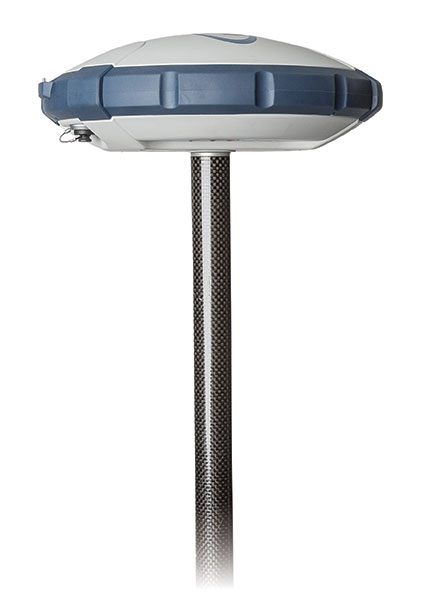
    The Spectra Precision SP60 is rugged and waterproof, yet compact, lightweight and ergonomic for ease of use in the field. The received also includes a patented inside-the-rod mounted UHF antenna. When the UHF transmit radio module is used, its UHF antenna remains protected inside the rugged rod, extending the radio range performance.

    “The Spectra Precision SP60 introduces a new level of configuration flexibility to the surveying market,” said Olivier Casabianca, business area director of Trimble’s Spectra Precision Division. “The SP60 was designed as an extremely versatile receiver, allowing surveyors to make it suitable for a specific surveying project, and then upgrade it to a more complex solution, when needed.”

  • Get Full Advantage from Many Profitable Features In One Compact RTK Rover

    Get Full Advantage from Many Profitable Features In One Compact RTK Rover

    TR-LS-JAVAD-Triumph-W
    The TRIUMPH-LS receiver, by JAVAD GNSS.

    The TRIUMPH-LS and its field software, J-Field, have many revolutionary and innovative features compared to current GNSS systems. Here is a quick overview of its most salient features, making it an ideal unit for surveyors in the field and managing from the office.

    The TRIUMPH-LS contains everything needed to function as a complete RTK rover in one small, compact, ergonomic and very portable unit:

    • an 864-channel GNSS receiver
    • a UHF or spread spectrum radio, a GSM modem
    • a Wi-Fi adapter
    • two internal cameras
    • a flashlight
    • a bright 800 x 480 pixel display.

    Also included with the system is a collapsible monopod rover pole which allows the unit to be quickly folded up to fit in a very small space, perfect for carrying the system in the field or quickly stowing inside a vehicle. The lack of a data collector bracketed to the rover pole further increases its portability; the user can carry the system through the woods without having to worry about an extruding data collector getting caught in brush.

    This system was ergonomically engineered; the head-height vertical display allows the user to operate the TRIUMPH-LS while standing in an upright position and looking forward. Users do not need to bend their neck to look down to view the display, as is traditionally done with a system having a data collector attached to a rover pole. This Triumph feature allows the system to be used without the neck soreness that can plague a user after working for extended periods of time.

    The TRIUMPH-LS contains a built-in compass and tilt sensors. The compass enables quick and efficient stake-out of points. Forward/back and left/right offset readings relative to the face of the display show precisely where the stake-out point is located. This stakeout method reduces the time required for this task, compared to using traditional north/south and east/west offsets. The built-in tilt sensors can be used in lieu of having to plumb the rover pole. Taking advantage of the tilt sensors is also a “Lift & Tilt” mode that means topo points can be collected without pressing any buttons. In this mode, when the TRIUMPH-LS is plumbed, a point will automatically start collecting and can be programmed to collect a set number of epochs or to stop collection when the unit is tilted. After the point is collected, the user tilts the TRIUMPH-LS and walks to the next point, which will be collected when the unit is plumbed again.

    Software. The field software, J-Field, is included at no extra charge with the system. There is no need for an external data collector or software. J-Field is constantly being improved, and updates will always be available free of charge with the system.  The updates can be downloaded through Wi-Fi and are very simple to install, requiring only a couple of button presses to update the system.

    J-Field features six separate, parallel RTK engines that all run simultaneously with separate assumptions. This allows for fixes to be obtained quicker than if only a single RTK engine were used. It has an advanced RTK verification system that can be used in difficult RTK environments where there is high multipath and/or tree canopy cover. This process will automatically reset the RTK engines and eliminate points from being collected with bad RTK fixes that often plague other systems in difficult locations.

    With the built-in GSM modem, it is very easy to connect to real-time networks (RTNs). Alternately, it can also be connected through Wi-Fi using a mobile hotspot.

    Full CAD features are in the process of being developed for use with the map screen. The ability to draw lines, polylines, circles and arcs will be supported. Using the planned move, copy, offset and rotate commands, much of the same CAD work that is traditionally done in the office will now be able to be completed in the field. This very beneficial feature can reduce the number of return visits to a project site.

    J-Field has many customization features that can be used to increase productivity as your knowledge of the system grows. The stake and collect screens have eight white boxes that are easily customized to display a number of fields that the user may desire.

  • Averna Launches RF Record & Playback with Real-Time GNSS Simulator

    Averna Launches RF Record & Playback with Real-Time GNSS Simulator

    Averna RP-6100 Series (PRNewsFoto/Averna).
    Averna RP-6100 Series (PRNewsFoto/Averna).

    Averna has launched an RF tool offering high-performance record-and-playback and real-time simulation in one platform.

    The Averna RP-6100 series is a self-contained, record-and-playback solution for RF application validation. It can capture all GNSS bands, as well as HD Radio, Wi-Fi, LTE, radar, and cognitive radio — plus impairments — to significantly advance RF projects and harden product designs. The RP-6100 series features up to four channels, 160 MHz of recording bandwidth, tight channel synchronization, an extended frequency range of 10 MHz to 6 GHz, and 14-bit resolution.

    The RP-6100 can also be equipped with Skydel Solutions’ software-defined, real-time GNSS simulator, which delivers easy setups, integrated maps, dynamic scenario creation, high precision and tight parameter controls to enable highly repeatable simulations of current and future GNSS conditions, as well as corner cases.

    Features include:

    • Frequency range of 10–6000 MHz, covering all GNSS bands, plus HD Radio, WiFi, LTE, and more
    • Multi-channel (1-4): Up to 160 MHz of bandwidth at 14-bit resolution (< 1 Hz)
    • 3.8 TB SSD storage or 16 TB HDD storage (for up to 22 hours of recordings)
    • Preloaded with RF Studio software for quick setups and in-depth analysis
    • Four models: RP-6120 (2 ch.), RP-6120P (2 ch. portable), RP-6120D (2 ch. desktop) and
      RP-6140 (4 ch.)
    • Optional real-time Skydel GNSS Simulator for complete GNSS corner-case/testing scenarios

    “We are very excited to partner with Skydel Solutions as a way to continue to provide our customers with the latest technologies and products,” said Benoit Richard, VP of Innovation & Strategy at Averna. “Their technology maps perfectly with our portfolio of RF instrumentation solutions, which empower device manufacturers to efficiently generate, record, simulate, analyze, and play back all common radio, video, and navigation signals, ensuring complete test coverage and the highest quality for their RF products.”

    “Today, Skydel is proud to introduce its software-defined GNSS Simulator, running in real-time Ettus and NI USRP hardware,” said Stéphane Hamel, co-founder and CEO of Skydel Solutions. “We are also very pleased to announce that our GNSS Simulator can be combined with Averna’s RP-6100 Series. These technologies complement each other perfectly, making the combined solution the ideal platform for high-performance design validation of RF and GNSS devices.”

  • Avenza PDF Maps v2.5 for iOS Highlights Pan and Zoom

    pdfmaps-ipad-tools-WAvenza Systems Inc., a developer of cartographic software — including MAPublisher for Adobe Illustrator and Geographic Imager geospatial tools for Adobe Photoshop — has released PDF Maps app 2.5 for iOS devices with enhanced features.

    Avenza’s PDF Maps app and mobile solution is used for both personal and commercial purposes and incorporates more detailed functions commonly needed when tracking, plotting points, navigating and collecting data in areas where Internet service is unavailable. To date, Avenza’s PDF Maps app has grown its commercial side to more than 30,000 regular users.

    Paired with mobile devices that use GPS, such as a smartphone or tablet, the PDF Maps app provides constant access to geographic locations without the risk of losing reception due to cell-tower proximity. Over the years, the app initially attracted the attention of recreational users such as hikers who traveled through rugged areas.

    Today, PDF Maps app has developed a growing list of commercial users globally, including the military, wild fire units, search and rescue teams, and conservation groups that use the app to record data, document with images and share detailed navigation points with others quickly and easily. Based on the various types of environments the app is being applied in, Avenza has further developed its latest features based on the feedback and specifications of its users. These include:

    • Enhanced navigation: ability to establish both GPS position and compass.
    • Measurement: tools to calculate distances, size and areas.
    • Map use: capable of overlaying search engine results on any map for offline use.
    • Map Collections: convenient map searching tools including the ability to pan and zoom between maps.
    • Personalization: ability to load a user’s own geospatial PDF, GeoPDF, GeoTIFF, JPG and TIFF maps and imagery from a file system, Dropbox, URL or email.

    pdfmaps-placemarks-W“Avenza’s PDF Maps app has always been popular with the recreational groups who often use the free app for use while in the air, on land or sea excursions. The mapping resource has helped many novice and expert outdoor enthusiasts navigate through areas where most digital maps fail in the details,” said Ted Florence, president, Avenza Systems Inc. “Recently, the popularity experienced on the recreational side is now being felt on the commercial end as many organizations that work in remote areas, and require use of their own custom maps and drawings on smartphones or tablets, need the ability to locate themselves and make notations and share information on detailed maps quickly. Avenza is excited to see the growth of PDF Maps, not just as a product, but as a valuable tool that is aiding commercial users such as conservation teams and similar groups. We hope the latest features of PDF Maps app 2.5 helps make a difference in their work.”

    Currently, Avenza’s vast PDF Maps app library covering maps for domestic and international destinations includes more than 100,000 maps organized by country, state and area. All maps available through the in-app iTunes-like map store offer the following capabilities:

    • Access and load maps through in-app purchase, iTunes File Sharing, Wi-Fi or cellular network to read maps anytime.
    • Access and interact with saved maps without the need for a live network connection (offline).
    • View your location on the PDF map using the built-in GPS device or via Wi-Fi triangulation.
    • Find coordinate of any location in the map, including the ability to type in a coordinate to search.
    • Display coordinates as Lat/Long (WGS84), Lat/Long (Map Default), Northing/Easting, or Military Grid Reference System (MGRS/United States National Grid (USNG).
    • Support for GeoTIFF files to create tiles similar to how a geospatial PDF is tiled.
    • Map rendering in higher resolution.
    • Overlay Google search results.
    • Add waypoints and collect/record information about locations, including photos.
    • Measure distances and areas.
    • Open current map extents in the Maps app.
    • Quickly view, zoom and pan maps using gestures (pinch, drag and flick, double tap).
    • Change pin colors, position and label names.

    PDF Maps app 2.5 is available now on the iTunes App Store free of charge for personal and private use. PDF Maps app is also available for use with Android devices in the Google Play Store free of charge for personal non-commercial use. A Windows version is currently in public beta targeted for a release later this year. Commercial, government and academic use licensing is available for a nominal annual fee.

    For more information about PDF Maps, visit the Avenza website or the PDF Maps website. Pricing of each map is set by the publisher and free maps remain free to users through the PDF Maps app in-app store.

  • OriginGPS Multi Spider Powers CSRmbed Shield GNSS/GPS Module

    OriginGPS-wearable-chip-TThe OriginGPS Multi Spider module provides high sensitivity and noise immunity by incorporating its proprietary Noise Free Zone technology for faster position fix and navigation stability even under challenging satellite signal conditions.

    SiRFstarV — CSR’s GNSS receiver that tracks both GPS and GLONASS satellites — has the CSR mbed Shield, which comes fitted with the OriginGPS Multi Spider module (ORG4572) requiring 1V8 supply, ground, UART interface and connection to GNSS capable antenna. Additional IOs are available for interrupts, turning the receiver on and off, reset, fix status and power mode information.

    The OriginGPS Multi Spider is a tiny GPS + GLONASS module designed to support ultra-compact applications in which size is at a premium, such as smartwatches, wearable devices, trackers and digital cameras. It is a fully integrated, highly sensitive GPS + GLONASS receiver module measuring 7 x 7 x 2.1 millimeters.

    The Multi Spider continuously tracks all GPS and GLONASS satellites in view and provides real-time positioning data in the standard industry format, defined by the U.S. National Marine Electronics Association (NMEA).

    For more information about GPS/GNSS modules, visit OriginGPS.

  • MachineryGuide Offers Smartphone Guidance for Agriculture

    MachineryGuide Offers Smartphone Guidance for Agriculture

    The MachineryGuide package with antenna, receiver and guidance software.
    The MachineryGuide package with antenna, receiver and guidance software.

    MachineryGuide is a new GPS guidance system for Android that gives farmers the ability to use their smartphones for precision guidance.

    With the help of MachineryGuide, the cultivated area and overlaps can be displayed. The guidance application helps farmers in edging along the ideal track by gearing to straight reference lines.

    With the application and an antenna from MachineryGuide, farmers can have a simple precision guidance application to improve yield growth, increasing efficiency. Also, fertilizer and pesticide use can be optimized, while machine costs and work hours can be lowered by up to 10 percent, the app designers said.

    The application is aimed at managers of small- and medium-sized farms and can be used on a smartphone or tablet. A demo can be downloaded from GooglePlay — the free version can not connect to a real GPS device, but all the functions of the program can be tested.

    MachineryGuide sells the software separately; a GNSS receiver + antenna separately; and a package bundle that includes software, GNSS receiver and antenna. The antenna is capable of receiving and processing free corrections (EGNOS, WAAS).

    MachineryGuide has been listed among the top 5 farming apps according to Agrivi. Also, Croplife considers MachineryGuide one of the 10 best agricultural apps of 2015.

  • UAV Product Showcase

    UAV Product Showcase

    BramorRTK-C-Astral-W

    GNSS Post-Processing UAS

    The Bramor RTK GNSS Post-Processing UAS is designed for surveying and remote-sensing applications that need a quick, high-precision set of results down to sub-centimeter level in the absence of a grid of ground control points. It is equipped with C-Astral high-rate GPS and IMU precision data-logging electronics. The system has both air and ground segments, consisting of a GNSS onboard receiver and ground base station. It has an L1 and L2 GNSS reciever (GPS, GLONASS, BeiDou and Galileo-ready), plus a survey-grade antenna.

    C-Astral, www.c-astral.com


    QuestUAV-water-W

    Aqua Drone for Offshore Missions

    The QuestUAV Aqua Pro is designed for offshore/onshore data-gathering in fields such as environmental, gas and oil, coast guard and security. It is a fixed-wing waterproof UAV based on the QuestUAV 200 airframe.

    The Aqua Pro is capable of offshore missions and recovery in both fresh- and salt-water environments. It can withstand pressure differentials induced by rapid temperature changes, and overcome complexities of waterproofing/marine-grade electronics, sensors and avionics. It uses a GPS unit from SkyCircuits.

    QuestUAV, www.questuav.com


    GAJT-AE-34-W

    Electronic Warfare System

    NovAtel’s GAJT-AE GPS anti-jam technology is designed for military and security weight- and size-constrained airborne and ground unmanned platforms, including UAVs. GAJT-AE provides the null forming antenna control electronics for a four-element controlled reception pattern antenna.

    NovAtel, www.novatel.com


    RIEGL_RiCOPTER_W

    High-Accuracy Laser Scans

    The Riegl RiCopter is an unmanned multirotor UAS, integrating a high-performance and complete LiDAR system, the RIEGL VUX-SYS. The VUX-SYS comprises the VUX-1 LiDAR sensor, the Applanix AP20 IMU/GNSS system, a control unit, and up to four high-resolution cameras.

    The Riegl RiCopter can acquire high-accuracy, high-resolution laser scan and image data. The excellent measurement performance of the VUX-1 in combination with a precise fiber-optic gyroscope and GPS/GLONASS receiver results in survey-grade measurement accuracy in fields such as precision farming, forestry and mining. The IMU/GNSS unit provides roll and pitch accuracy of 0.015 degrees and heading accuracy of 0.035 degrees. Riegl is a maker of laser scanners, and using a high-end unmanned airborne platform allows data acquisition in dangerous and hard-to-reach areas.

    Riegl, www.riegl.com


    eBee-RTK-over-mine-W

    Survey-Grade Mapping Drone

    The eBee RTK by senseFly is a fully autonomous survey-grade mapping drone with a built-in L1/L2 GNSS receiver capable of receiving corrections from most leading brands of base station. This ensures high positional accuracy without the need for ground control points, so the aerial photography can produce orthomosaics and 3D models with accuracy down to 3 centimeters. It has 226 channels and tracks GPS L1, L2, L2C; GLONASS L1, L2, L2C; and SBAS.

    Sensefly, www.sensefly.com

  • Trimble’s New OEM Module Combines GNSS with MEMS Inertial

    Trimble’s New OEM Module Combines GNSS with MEMS Inertial

    Trimble BD935-INS module.
    Trimble BD935-INS module.

    Trimble has introduced the Trimble BD935-INS module that features precision GNSS with an integrated 3-D Micro-Electro-Mechanical Systems (MEMS) inertial sensor package. As part of Trimble’s GNSS OEM portfolio, the new compact module augments real-time precise positioning with 3-D orientation.

    The BD935-INS module’s simple connectivity and configuration capabilities allow system integrators and OEMs to easily add GNSS and attitude to specialized or custom hardware solutions, Trimble said in a news release.

    Trimble made the announcement at AUVSI’s Unmanned Systems 2015 Conference and Exhibition.

    “The OEM and system integrator communities demand high performance, reliability and support for their positioning solutions,” said Dale Hermann, general manager of Trimble’s Integrated Technologies Division. “The Trimble BD935-INS delivers the latest GNSS and inertial technology in an easy-to-integrate form factor for demanding conditions and applications such as lightweight robotic or unmanned vehicles. With the BD935-INS module, customers are purchasing a robust navigation solution, extending performance beyond that of a GNSS receiver only.”

    Taking advantage of Trimble’s expertise in both GNSS and inertial technologies, the Trimble BD935-INS module has been designed for applications requiring both RTK and orientation in a compact package. By integrating inertial sensors onto the GNSS module, users can experience more robust performance in a variety of challenging environments, Trimble said.

    The BD935-INS features triple frequency for both GPS and GLONASS constellations, as well as dual frequency for BeiDou and Galileo. The module delivers fast and reliable RTK initialization for 1–2 centimeter positioning. For applications that do not require centimeter accuracy, the BD935-INS integrated GNSS-inertial engine delivers high-accuracy GNSS and DGNSS positions in challenging environments such as urban canyons, tunnels, heavy canopy or other GNSS-denied environments, the company said.

    Trimble also announced the new BX935-INS, which is an environmentally rugged enclosure for OEM or system-level integration. The BX935-INS houses the Trimble BD935-INS module for easy installation and immediate access to high-rate position and attitude data for a variety of applications.

    The Trimble BD935-INS and BX935-INS is expected to be available in the third quarter of 2015 through Trimble’s Integrated Technologies Precision GNSS sales channel.

  • SenseFly Launches Intelligent Mapping and Inspection Drone

    SenseFly Launches Intelligent Mapping and Inspection Drone

    Photo: SenseFly

    Swiss professional drone maker senseFly has launched the eXom, its new quadcopter UAS for mapping and inspection. The eXom is available to pre-order immediately and ships this summer.

    SenseFly made the announcement at the AUVSI Unmanned Systems 2015 show being held May 4-7 in Atlanta, Ga. (Hall B2, Booth 519).

    The eXom is a sensor-rich system, sensefly said. Developed by experts working across numerous fields of robotics, this lightweight quadcopter offers professionals such as civil engineers and land surveyors the situational awareness, imaging flexibility and durability they need to complete challenging tasks safely, accurately and efficiently.

    “We believe the eXom’s level of application-focused technology is unique in the civilian drone market,” said Antoine Beyeler, CTO and co-founder of senseFly. “This platform tightly integrates several one-of-a-kind features, such as TripleView imaging, advanced situational awareness and full flight mode flexibility — to provide inspection and mapping professionals with the functionality they desire from a rotary system.”

    eXom is a future-ready platform with a quad-core computer onboard, senseFly said. Like senseFly’s fixed-wing drones, it offers users evolving performance through regular software updates, adding the latest drone tech innovations to keep the eXom at the cutting edge for years to come, the company said.

    eXom’s low take-off weight of 1.7 kg (3.7 lb) ensures its users will, in many countries, have less flight authorization paperwork to deal with than those who use heavier systems.

    The eXom’s advanced integrated sensors work together to provide the user with full situational awareness and support obstacle avoidance:

    • Five navcam vision sensors allow the operator to see in the direction the drone is moving, automatically via its flight control software, without needing to turn the system’s TripleView camera head. This technology is similar to the visual parking sensors in modern cars, but brought into a 3D flight environment.
    • Five ultrasonic proximity sensors work in harmony with eXom’s navcams to ensure the operator always knows the drone’s distance from nearby objects. (The drone’s shock-absorbent carbon fibre shrouding is also always on hand to protect its rotors in case of surface contact.)
    • Numerous other sensors, including inertial measurement units, barometers, magnetometers, GPS and magnetic encoders, maximize the drone’s stability and safety.

    eXom’s autopilot-controlled TripleView camera head enables the user to view and record three different types of imagery during a single flight without needing to land to change cameras:

    • HD video
    • Ultra high-resolution stills
    • Thermal still/video

    Because the TripleView head faces forwards, eXom can fly up close to target structures such as building walls and dams to achieve sub-millimeter data resolutions. Plus, with the head’s 270-degree vertical field of view, users can document objects positioned directly above and below the drone — crucial for tasks such as bridge and roof inspections.

    eXom offers various flight modes:

    • Autonomous mode — for mapping projects. First, create a flight plan using eMotion X’s mission blocks. eXom then launches, flies, acquires geo-referenced imagery and lands itself.
    • Interactive ScreenFly mode — this streaming video mode is for live inspection tasks. Use the supplied joypad to navigate and orient the drone via computer screen. This mode includes flight assistance features such as cruise control and distance lock.
    • Create a flight plan, launch in autonomous mode, then go live on demand.
    • No matter which mode is activated, RC-based manual control always remains available as a backup function and for experienced pilots.

    Full technical specifications can be downloaded on this PDF.

    Visit senseFly at Unmanned Systems 2015: Hall B2, Booth 519. The eXom will be demonstrated in flight at the senseFly booth at at the show’s Air & Ground Demo Area (demo timings: May 6, 12:15 and 14:15, May 7, 11:45 and 14:15).

  • Septentrio Launches UAS Receiver, Software for Drone Market

    The AsteRx-m UAS by Septentrio.
    The AsteRx-m UAS by Septentrio.

    Septentrio has launched the AsteRx-m UAS, an RTK-accurate GNSS receiver solution specially designed for the drone market. The AsteRx-m UAS provides high-accuracy GNSS positioning with low power consumption, according to Septentrio.

    The launch of the AsteRx-m UAS board is complemented by the release of GeoTagZ software suite. The GeoTagZ suite works with the UAS camera and image-processing solution to provide centimeter-accurate position tagging of images without the need for a real-time data link.

    The AsteRx-m UAS will be on display at booth #635 during AUVSI’s Unmanned Systems 2015, held May 4-7 at the Georgia World Congress Center in Atlanta.

    Despite being Septentrio’s smallest receiver, the AsteRx-m UAS provides consistent, robust and accurate positioning from to Septentrio’s in house GNSS+ algorithm technology. The receiver delivers cm-level accuracy at less than 600 mW with GPS and less than 700 mW with GLONASS. LOCK+ technology guarantees tracking under heavy usage and IONO+ guarantees no interference in challenging ionospheric conditions, Septentrio said.

    Integration into Any UAS. One of the key characteristics of AsteRx-m UAS and GeoTagZ is the seamless integration into any UAS. AsteRx-m UAS features standard connection functionality that directly connects to a UAS autopilot, such as Pixhawk and Ardupilot. The power comes directly from a number of power sources, including micro USB, a 9-30V external power supply or the vehicle power bus. GeoTagZ is available as a library of software to integrate into an UAS image-processing tool chain.

    “We want to make UAS-based data collection and processing extremely simple. AsteRx-m UAS and GeoTagZ do just that,” said Jan Leyssens, commercial product manager at Septentrio. “The GNSS board connects seamlessly to standard hardware and cameras used on a drone. Together with our software, we provide a data collection solution that provides cm-level accuracy without the need for ground control points or real-time data links, and that integrates effortlessly with an existing UAS image processing software solutions.”

  • AirMap Digital Map Enables Safe, Legal Drone Flying

    AirMap-O

    AirMap — a free, comprehensive digital map — allows unmanned aircraft system (UAS) operators to visualize the airspace around them, including areas where they may not be permitted to fly.

    AirMap removes barriers to compliance of complex airspace rules by providing the low altitude airspace information that unmanned aircraft operators need. AirMap was cofounded by aviation expert and entrepreneur Ben Marcus and Gregory McNeal, a legal scholar on drones, public policy and air rights.

    AirMap integrates multiple sources of reliable data and gives UAS operators an easy-to-use, yet detailed, solution providing a single view of the restricted areas around an area of operations, its makers said. The beta version of the site is now live in the U.S. and will launch soon internationally, enabling UAS operators to immediately start benefiting from the free service. AirMap also features a feedback function that will allow beta testers to request additional features.

    AirMap is a fully digital map that shows only the airspace rules that impact UAS operators. By focusing on airspace information from ground level up to 500 feet, AirMap strips away the clutter of higher altitude airspace labels found on charts that were created for manned aviation, its makers said.

    When using AirMap, an operator can customize their display based on the type of operation they are involved in. Operators can select layers depicting the following:

    • Recreational use, which will display the airspace areas around airports which are limited by community-based guidelines;
    • “Blanket COA” rules applicable to holders of FAA Section 333 exemptions for commercial UAS operations; and
    • Controlled airspace (Class B, C, D, and E) at 500 feet and below, allowing UAS operators to voluntarily comply with the airspace rules proposed in the FAA’s recent Notice of Proposed Rulemaking on the Operation and Certification of Small Unmanned Aircraft Systems.

    “As UAS use continues to expand, the airspace in which operators are flying is also growing more complex. With this in mind, we’ve launched AirMap, which will serve as a resource for drone operators to immediately fly safely and in compliance with legal requirements. We want to make safe flying easy,” Marcus said.

    Marcus and McNeal teamed to launch AirMap after they realized that operators needed a tool that would let them understand the complexities of restricted airspace for unmanned aircraft operations. Marcus, who co-founded aircraft brokerage firm jetAVIVA, will lead development and business growth functions. McNeal will apply his expertise and research in local regulatory environments to help AirMap reach and educate users throughout the country. In addition to his role with AirMap, McNeal is an associate professor of law and public policy at Pepperdine University and a Forbes contributor.

    “As a drone operator I found it hard to know what the airspace rules were in the places where I wanted to fly. There were no accurate visuals or reliable electronic tools that could tell me and other operators where we can and cannot fly. AirMap solves this problem and helps to educate operators about this complex regulatory environment,” said McNeal. “The demand for AirMap is clear, as it is the most thorough resource for drone operators to ensure safe, legal and hassle-free flight.”

    AirMap’s advisory board includes Steve Crocker, chairman of the ICANN; Stuart Banner, UCLA law professor and author of Who Owns the Sky?; Tom McInerney, former scientist at Apple; and Mike Mothner, founder and CEO of WPromote.

    In February 2015, AirMap launched its first service, NoFlyZone.org, which accepts registrations from property owners who prefer UAS not overfly their land. These parcels are displayed in AirMap to help operators avoid sensitive areas, and minimize the hassles associated with disputes about where unmanned aircraft should be operating. AirMap also displays hospitals, schools and helipads and will be adding other sensitive sites in the future.

  • 4D Inspector for Building Monitoring Comes to MundoGEO

    Gexcel’s 4D Inspector will be officially presented to the South American market during MundoGEO, to be held in Brazil May 5-7.

    4D Inspector software can remotely manage any Focus3D laser scanner and run an automatic 3D monitoring session of buildings and infrastructures. 4D Inspector automatically transfers the scans to a remote PC where automatic deformation check runs and alarm emails can be sent to the site managers.

    If required, 4D Inspector can also control a protective enclosure (ScanArmor) that can protect the Focus3D from damages.

    The 4D Inspector+ScanArmor system has won the FARO Asia Pacific Product Innovation Award 2014. Designed for real-time monitoring of indoor application, 4D Inspector is has easy-to-use interface and installation procedures, according to maker Gexcel Software Solutions.

    Gexcel will provide will provide an interactive demo at its booth, #187, at MundoGEO.