DT Research Inc. has launched a new line of rugged tablets with the GNSS modules for surveying and mapping applications. The DT391GS, DT395GS and DT307GS rugged tablets feature integrated high-accuracy GNSS receiver modules with built-in antenna for seamless data capture, the company said.
Built to travel and provide reliable operations in the real world, the tablets are designed for field work in mapping, geographic information systems (GIS), and accurate synchronization, tracking and networking.
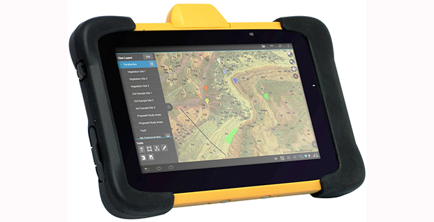
The DT391GS combines a 9-inch sunlight-readable, capacitive touch display with an energy-efficient Intel dual-core processor in a compact, durable package. With the high-accuracy GNSS module options (Hemisphere or Trimble), the foldable antenna, and Windows or Android operating system. The DT391GS also offers protection in demanding environments with IP65 and MIL-STD-810G ratings for dust and water, and shock and vibration resistance.
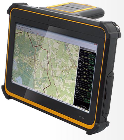
The DT395GS tablet.
The DT395GS offers a 9-inch sunlight-readable capacitive touch screen, an energy efficient Intel dual-core processor, and a choice of Windows or Android operating systems. The GNSS positioning module has u-blox GNSS module. The IP65 rating, and military-standard MILSTD-810G and MIL-STD-461F ratings, as well as wide temperature range, make the DT395GS reliable even in harsh, mission-critical environments.
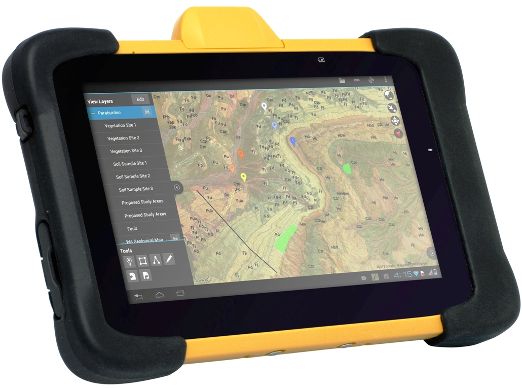
The DT307GS GNSS tablet features a brilliant 7-inch capacitive touch screen and a quad-core, energy efficient processor with a built-in, high-accuracy u-blox GNSS module. The size and weight of the DT307GS make this tablet portable for long-term handling in the field, DT Research said.
The DT307GS tablet
All of the DT Research Rugged GS Tablets offer hot-swappable batteries for continuous operation, enabling real-time project efficiency between staff in the field and in the office. With wireless support for Bluetooth, 802.11, WCDMA and HSPA+ connectivity and optional GSM networking, the tablets keep staff connected from any location.
The DT391GS and DT395GS have Trusted Processing Module (TPM) encryption for security support, and a choice of Microsoft Windows Embedded Standard 7 or 7 Professional, or Android operating system making these tablets flexible to integrate with existing applications.
An optional 5-megapixel camera offers another data capture tool to record visual information, and an optional 3G cellular data module provides data connectivity for navigation and real-time data transfer, DT Research said.
The DT391GS, DT395GS, and DT307GS are available now, form more information, contact DT Research at [email protected].
The GPS World Galileo Product Showcase, from the April 2015 issue, features the latest products from seven top companies.
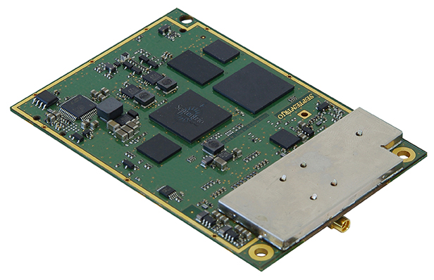
GPS/GLONASS/Galileo Receiver
Septentrio AsteRx3 Photo: Septentrio
The AsteRx3 is a multi-frequency GPS/GLONASS/Galileo receiver is designed for demanding industrial applications. AsteRx3 features simultaneous high-quality GPS, GLONASS and Galileo tracking and a range of innovative features, such as the patented Galileo AltBOC tracking, the advanced multipath mitigation algorithm APME, LOCK+ tracking for exceptional tracking stability under high vibration conditions, RTK+ for extended RTK baselines and faster initialization, and AIM+, Septentrio’s Advanced Interference Mitigation technology, offering centimeter-level measurement quality for high-precision positioning, even in challenging environments.
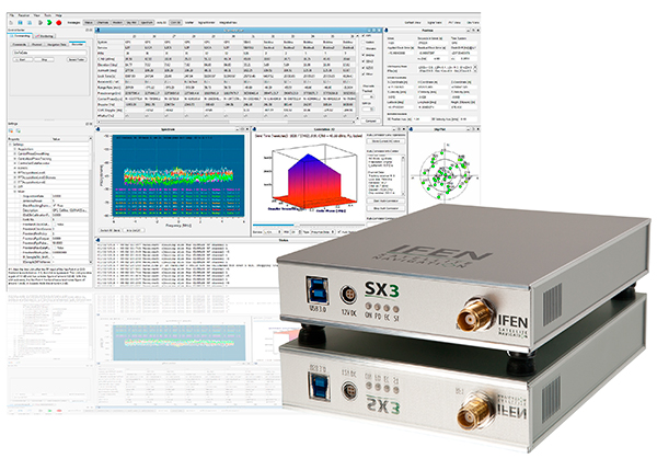
The IFEN SX3 multi-GNSS software receiver Photo: IFEN
IFEN’s SX3 multi-GNSS software receiver tracks all known GNSS signals in view, including Galileo signals, in real time on a standard laptop now and in the foreseeable future (up to 1,000 channels in parallel on a core i7). The included RF front end offers four RF frequency paths with 50-MHz bandwidth each, covering the entire GNSS L-band spectrum. The USB 3.0 interface enables high-speed data transfer with up to 8-bit quantization. An optional dual RF input front end can be used for attitude determination, reflectometry and other applications requiring the synchronized input from two antennas. An optional built-in shock and vibration robust OCXO reference oscillator (MIL-STD 202G) is available, which replaces the standard high-quality TCXO normally used.
The SX3 software lets users configure the data processing, including changing loop bandwidths, integration times and the main processing rate, and choosing between different correlation types. The software includes a multi-correlator providing a two-dimensional (code and Doppler) correlation function visualization in real-time. The receiver comes with several powerful processing algorithms like vector tracking, to improve the tracking of weak signals in degraded environments.
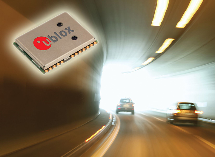
The NEO-M8L Automotive Dead Reckoning (ADR) module by u-blox has integrated motion, direction and elevation sensors. The module integrates gyro and accelerometer with u blox’ GNSS platform M8 to achieve high indoor/outdoor positioning performance for road vehicle and high-accuracy navigation applications.
The module is able to track all visible GNSS satellites including GPS, GLONASS, BeiDou, QZSS and all SBAS, with Galileo to be supported in a future firmware version. Concurrent reception of two GNSS systems is supported. The NEO-M8L module can output a position up to 20 times per second.
In addition to accessing the integrated module’s gyro and accelerometer data, accident reconstruction systems can provide the location of an accident to facilitate insurance claims even if a collision occurs in a tunnel or park house. High-end navigation devices are able to guide drivers through tunnels of several kilometers because of the accuracy of u-blox’ ADR system. Stolen vehicles can be located instantly due to continuous monitoring of sensor data and storage of location in non-volatile memory.
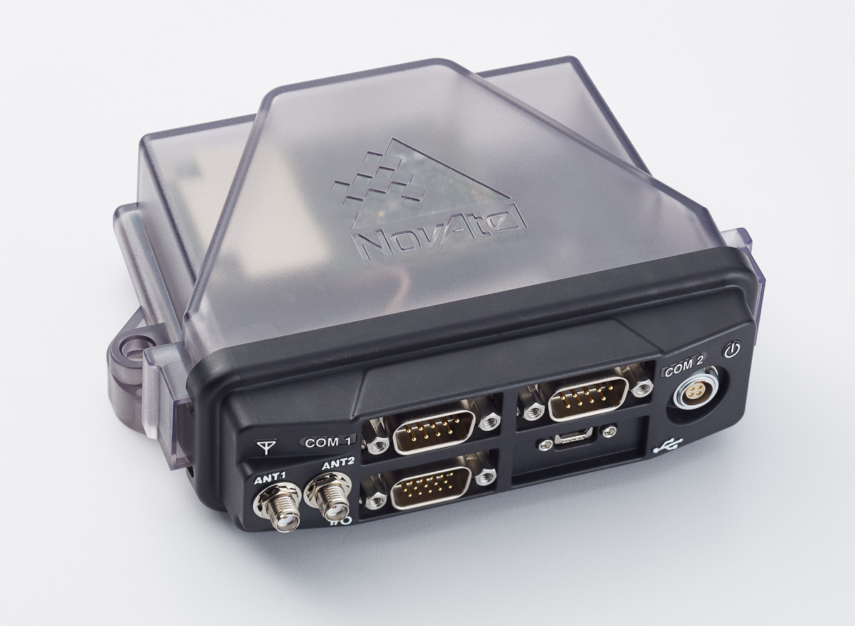
The NovAtel FlexPak6D enclosed GNSS receiver is a flexible dual-antenna solution for application developers seeking a high-precision heading-capable positioning engine for space-constrained applications.
Designed for efficient and rapid integration, the compact receiver tracks Galileo as well as GPS, GLONASS and BeiDou. Antenna placement is flexible: the antenna baseline can be set according to space available on a vehicle and heading accuracy required. The modular OEM6 firmware enables users to configure the receiver for unique application needs. Scalable for sub-meter to centimeter-level positioning, the FlexPak6D delivers NovAtel’s ALIGN precision heading and relative heading firmware, as well as its GLIDE firmware for smooth decimeter-level pass-to-pass accuracy and RAIM for increased GNSS pseudorange integrity.
The GNSS simulator in the vector signal generator R&S SMBV100A Photo: R&S
The GNSS simulator in the vector signal generator R&S SMBV100A is designed for development, verification and production of GNSS chipsets, modules and receivers. The simulator supports all possible scenarios, from simple setups with individual, static satellites up to flexible scenarios generated in real time with up to 24 dynamic Galileo, GPS, GLONASS, BeiDou and QZSS satellites. The simulator also supports Assisted GNSS (A-GNSS) test scenarios, including generation of assistance data for Galileo.
The simulator offers real-time simulation of realistic constellations with up to 24 satellites and unlimited simulation time. Flexible scenario generation includes moving scenarios, dynamic power control and atmospheric modeling. Users can configure realistic user environments, including obscuration and multipath, antenna characteristics and vehicle attitude.
The all-in-one TRIUMPH-LS by JAVAD GNSS combines a high-performance 864-channel GNSS receiver, all-frequency GNSS antenna, and a modern featured handheld. The 864 all-in-view channels include Galileo E1/E5A/E5B, GPS L1/L2/L5, GLONASS L1/L2/L3, QZSS L1/L2/L5, BeiDou B1/B2 and SBAS L1/L5.
The TRIUMPH-LS offers GUIDE data collection, Visual Stake-out (VSO), navigation, six parallel RTK engines, more than 3,000 coordinate conversions, advanced CoGo features, and rich attribute tagging on a high-resolution, bright, 800 x 460 bright display. Two 3-megapixel cameras enable recording of images along with GNSS data.
With VSO, the virtual location of a point to be staked can be seen by a “flag” shown on the Triumph-VS camera image. This visual aid helps users navigate quickly to a point and makes stakeout jobs fast and easy. VSO can be used as a convenient way to get close to a target point before switching to the regular stakeout mode to perform precise measurements.
More than 100 channels are dedicated to continuous interference monitoring. The Triumph-LS monitors and reports interference graphically and numerically with patent-pending interference protection. Interference awareness allows safe GNSS operation in a city, airport and military environment.
The unit can serve as base or rover. It has a GSM modem, UHF transmit and receive, and an internal high-performance geodetic antenna.
The TRIUMPH-LS automatically updates all firmware when connected to a Wi-Fi Internet connection.
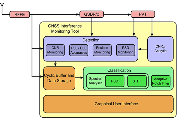
TeleOrbit’s software-defined radio receiver and GNSS interference monitoring tool receives and processes all available Galileo signals. Signals that are not yet transmitted and interference sources can be simulated and processed within the software tool.
Within a software-defined radio framework, the analog-to-digital converter is moved as close as possible to the antenna to perform most of the signal processing in software. This leads to adaptable solutions with lower hardware costs that can be easily extended to new signals and systems with only a software update.
The GNSS Software Defined Radio Receiver (GSDR2X) developed by TeleOrbit’s sister company TeleConsult Austria can track most readily available signals from Galileo, GPS and SBAS. By utilizing input from TeleOrbit’s GNSS multi-system performance simulation environment (GIPSIE), even signals not yet transmitted by satellites can be tracked and processed by the GSDR2X. Furthermore, input data can be read from various radio frequency front-ends, either directly or from file.
The modular GSDR2X framework enables new capabilities, such as the GNSS Interference Monitoring Tool (GIMT), which enables the GSDR2X to detect and classify interfering and jamming signals (see figure).
IDV Solutions’ Visual Command Center is a physical security and risk visualization (PSRV) software that unites data from external sources, enterprise systems and internal devices into a real-time, common operating picture of risk and security.
IDV Solutions, a corporation that specializes in business intelligence, physical security and risk visualization software, has formed a technical partnership with Geofeedia, producer of a cloud-based social media monitoring platform. Through the partnership, Geofeedia’s location-based social media monitoring data will now be integrated into IDV Solutions’ Visual Command Center Enterprise Risk Visualization (ERV) software.
The companies say the combination of the two technologies enables security, supply chain and business continuity teams to gain instant intelligence from multiple social media networks for a myriad of risk events — from a political demonstration to a natural disaster. The location-based visualization filters out excess noise to show important social media posts in the context of locations of interest, such as facilities, employee locations, supply routes or traveling executives.
“Companies are looking for ways to efficiently gain actionable intelligence from social media,” said Ian Clemens, chief technology officer and co-founder of IDV Solutions. “The immediacy of social media combined with the alerting and locational context offered by Visual Command Center enables organizations to make more effective use of social media to protect employees, facilities and business continuity.”
The Visual Command Center provides a real-time, common operating picture of assets, personnel and operations in relation to potential threats to those assets. It unites information on global sources of risk — such as weather, terrorism and natural disasters — with data from internal data stores and physical security systems on an interactive map and timeline. When a risk is detected near an asset or employee location, the Visual Command Center automatically generates an alert and provides tools to assess whether the risk is a threat and take immediate action to mitigate the impact of the threat.
The Geofeedia integration complements the Visual Command Center’s Twitter Visualization and Alerting Module by providing information from more social media networks and visualizing all posts within a selected area.
Geofeedia enables organizations to filter and analyze social media content by location in real time across multiple sources. Users search for a city, address or location name, draw a virtual perimeter around the specific area of interest,and access geo-tagged social media content from within those boundaries.
“Location resolves the challenge of monitoring the massive amounts of cluttered data to identify meaningful, real-time on-the-ground intelligence when and where it matters most,” said Phil Harris, CEO and co-founder of Geofeedia. “We are thrilled to be able to help more organizations take advantage of our real-time, geotagged social media data to prevent, protect and respond to valuable intelligence.”
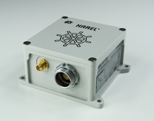
The VIA-100G GPS/IMU by Karel Electronics. Photo: Karel Electronics
The VIA-100G, an integrated GPS and MEMS-IMU (inertial measurement system), has been added to the ViaNav inertial navigation system family produced by Karel Electronics Corporation.
Featuring a high-accuracy fusion filter running on an embedded processor, the VIA-100G provides all the functions of a vertical reference unit (VRU), an attitude and heading reference system (AHRS) and integrated GPS/IMU system. The system contains GPS, 3D gyroscopes, 3D accelerometers, a magnetometer, a static pressure sensor and temperature sensors in a compact and rugged enclosure. The embedded processor provides driftless and real-time navigation information over a wide range of temperature in dynamic and static conditions, Karel said.
The sensors are integrated with a highly accurate fusion filter. A Kalman filter running on an embedded processor fuses data from the IMU, GPS, magnetometer, altimeter and barometer in an optimal manner to output highly accurate navigation solutions. VIA-100G outputs high-frequency position, velocity and attitude information in addition to calibrated 3D acceleration, rotation, magnetometer and pressure data.
The ViaNav product family includes other navigation products designed to be used in stability, guidance, control and navigation applications in industry. The VIA-100 line includes:
VIA-100I, is an inertial measurement unit with 3D accelerometers and 3D gyroscopes.
VIA-100A, is a 3 DOF AHRS that provides driftless real-time orientation information over the full 360 degrees of angular motion on all three axes. It includes 3D accelerometers, 3D gyroscopes and 3D magnetometers.
VIA-100A+, is a 3 DOF AHRS that provides driftless real-time orientation information. It includes a multi-IMU configuration and employs an optimum filter to lower IMU noise level. It provides 3D orientation with improved accuracy and reliability.
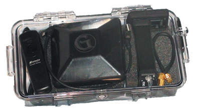
Geomatics USA from Gainesville, Fla., has designed a precision surveying and mapping system that can be easily stowed in an overhead compartment for airline travel. Surveyors can fit everything needed for important mapping and surveying jobs into a baseball-style bag, including tripods. The compact, light-weight system offers differential sub-foot accuracy.
Components easily pack into a baseball-style case.
The G1-m1 receiver system has many advantages over conventional GNSS receivers, Geomatics said. The system is designed for precision surveying jobs that require travel to remote areas of the world, and for traveling to job sites by commercial airline. The complete base and rover kit, including the tripods, rods, and batteries, fits into a single baseball style bag and weigh less than 10 kg, making it easy to stow as carry-on luggage.
The Geomatics USA G1 system is scalable from a simple single-frequency semi-mobile receiver — ideal for control networks and some semi-kinematic mapping applications — to a dual-frequency network RTK solution. All of the Geomatics USA G1 solutions perform precision-quality tasks at a fraction of the cost of major-brand equipment.
The G1-m1 system comes with a free processing software license for the first 50 systems that supports carrier-phase relative positioning and CA-code differential correction. The software is designed with a simple user interface for easy selection of base and rover data or automatic data download of the closest Continuously Operating Reference Station (CORS) from the U.S. National Geodetic Survey database. It is compatible with other RINEX based post-process systems around the world.
Complete survey set including GNSS receiver, antenna, battery and cables, fits in a small handheld plastic case.
According to Geomatics USA Chief Technology Officer Ahmed Mohamed, “The G1 product line fills the gap between survey applications, where cm-level precision is an absolute necessity, and mapping applications, where meter-level precision is acceptable. In fact, the G1-m1 product offers sub-foot precision in most cases and cm-level precision in ideal situations. Geomatics USA uses readily available components and open-source code to develop its end user product solutions. The objective is to make sure the software performs correctly with a very short learning curve for the user.”
For a limited time, Geomatics is offering a specially priced configuration for the first 50 systems through NavtechGPS, its worldwide distributor.
LandWorks Inc., a developer of innovative land management solutions, has introduced Release 5.20 of its three primary software suites — LandWorks Property Management, LandWorks GIS, and WebMaps Enterprise GIS. All three have been re-written for easier use, enhanced industry-specific functionality, and tighter integration with Esri GIS solutions.
“In Release 5.20, we rebuilt the software from the ground up with a combination of C# [Sharp] .NET and a service-oriented architecture,” said LandWorks President Jerry Bramwell. “This modern architecture allows for integration of live Esri GIS maps and builds a foundation for hosting in the cloud.”
Deployed extensively for land asset management and mapping in the oil and gas, utility, mining, pipeline, renewable energy and government sectors, the upgraded LandWorks software suites are expected to appeal to an even wider audience. In addition, their applicability within organizations will expand beyond land management to project planning, acquisition and development.
The flagship LandWorks Property Management (LPM) suite is a complete solution for land asset management designed for easy storage and retrieval of data relating to any type of land right. In the new LPM version 5.20, clients may open an oil and gas lease or right-of-way agreement and instantly access a live GIS map displaying the relevant polygons. Direct integration with Esri’s ArcGIS Server gives the client full web-based GIS functionality from within the LPM interface and the ability to update the live map with new information on the fly.
“LPM is the only land asset management software with embedded live access to Esri GIS maps,” Bramwell said.
The LandWorks suites, used worldwide, also have been internationalized to support the language, date, currency and measurement formats preferred by individual end users based on their locations. A large mining company with operations in multiple countries, for example, may deploy the LandWorks suites across its enterprise. End users in Portugal, Spain and Canada are able to view the same information presented in Portuguese, Spanish or English.
In addition to a more intuitive interface with a modern look and feel, LandWorks has added new functionality to the software products designed for greater ease-of-use in specific industries. The ability to make land royalty payments for mining and wind energy operations has been expanded. LPM and LandWorks GIS have been enhanced to better manage and present linear-based land rights.
“The enhancement of our products to better manage land rights associated with linear assets will make the LandWorks suites more attractive to transportation and telecommunications industries,” said Bramwell.
LandWorks has built new modules to the LPM suite to extend its usability across the entire land management workflow. LPM now manages land-related projects of any type or size including acquisition, surveying and encroachment investigation.
The three LandWorks suites comprise a total of 18 individually licensed software products, many of which can function alone or interface with LPM. LandWorks GIS integrates the Esri GIS functionality into LPM. WebMaps Enterprise GIS Suite extends web-based mapping via ArcGIS Server across the enterprise to all departments, not just the land department.
“All LandWorks software products currently reside behind the client’s firewall, however, we will soon offer hosting in the cloud as an additional licensing optional for our clients,” said Bramwell.
GPS tracking manufacturer Meitrack Group is introducing a tracker that runs on 3G networks. GPS trackers have been running on 2G networks, but soon many wireless carriers will discontinue the outdated 2G technology. Meitrack said it is hard at work making the transition to make all of its current trackers work on the 3G network standard.
The first model released is the T333 GPS tracker, which offers real-time tracking, history reports, assisted GPS tracking, geofence creation, and an S.O.S. panic button. The tracker can be installed in vehicles ranging from everyday family cars, to construction and commercial trucks.
The strong outer aluminum casing effectively secures the internal components from exposure to the elements and heat. At 190 grams, the T333 is lightweight and small enough to be securely installed in areas of minimal space, the company said. Meitrack has installed the u-Blox 7 GPS module, upgrading the processing speed and sensitivity. Not only does the T333 GPS tracker run on 3G networks, but it can also run on 2G as a backup if a 3G network is not available.
The T333 also comes equipped with digital and analog inputs that transform the GPS tracker into a central hub where other accessories can be simultaneously attached and synced. These accessories include fuel sensors, RFID card readers, handset phones, cameras, and even LCDs and LEDs displays.
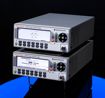
Spectracom GSG-Series GNSS Simulators have added capability to provide multiple RF outputs for advanced testing where multiple receivers or antennas are in use in a single system. Typical examples include controlled radiation pattern antennas (CRPA) or heading/attitude receivers and systems.
The intuitive StudioView software allows easy reconfiguration of test cases to change the conditions seen by one or all receivers and antennas under test — for example, adding a jamming signal to one antenna input on a CRPA receiver. Both over-the-air testing or cabled capabilities are available.
Because the simulator operates independently of PC control, the simulators can be precisely synchronized with a common clock and trigger pulse. There is no theoretical maximum to the number of RF outputs. This flexibility also allows testing multiple rovers reporting into a single control system, such as asset tracking or personnel location management systems.
This advanced feature is offered in both the L1 band GSG-5 series simulator for commercial applications as well as multi-band GSG-6 series simulator for professional applications.
TeleOrbit’s software-based GNSS multi-system performance simulation environment, GIPSIE, consists of a satellite constellation simulator and an intermediate frequency simulator. The digital signal simulator GIPSIE streams the software-generated signals or recorded live data exactly into the receiver’s baseband processing chain to support development, test, verification, validation, qualification and certification.
Features include simulation of multi-system, multi-frequency scenarios GPS L1/L2/L5 and Galileo E1/E5/E6; simulation of jamming signals on top of the GNSS signals; simulation of Galileo PRS-like signals as well as the unencrypted GPS P-Code signals; record and replay of recorded and software generated data. GLONASS and BeiDou constellations and signals and simulation of micro-electro-mechanical sensors (MEMS) are coming soon.
The Routescene LidarPod 3D mapper, a self-contained turnkey solution new to the market, is being showcased for the first time in the United States at the International Lidar Mapping Forum in Denver, Colo., Feb. 23-25. Routescene is based in Edinburgh, United Kingdom.
The flexible LidarPod was developed for use on unmanned aerial vehicles, but can also be fitted onto any mobile platform such as a car or boat. The flexibility makes it attractive for many sectors and situations where accurate mapping is essential but difficult to achieve, enabling surveys to be conducted in areas that previously would not have been considered, Routescene said.
The technology offers a non-intrusive method to obtain detailed and precise geo-referenced 3D datasets, Routescene said. LidarPod 3D can be used for 3D mapping; powerline inspection; scoping, planning and management of mines; forestry design, management and operation; large-scale topographic surveys; and city planning and management.
Routescene LidarPod costs less than a vehicle-based mobile mapping system, Routescene said. The turnkey solution includes LidarViewer, specially developed software to turn the raw data into valuable business information. It enables users to convert, analyze and filter huge volumes of point cloud data to improve productivity and workflow. Powerful filters enable users to extract relevant data for use in third party software, such as GIS and CAD packages, which are unable to cope with such large data volumes.
To meet the needs of high-accuracy field data collection and better workflow with modern GNSS technology, Supergeo’s latest SuperSurv GIS mapping app allows users to connect with and operate external Bluetooth GNSS devices. The app also elevates field-work efficiency with new averaging algorithms.
SuperSurv is designed for field data collection on Android and iOS-powered devices. Integrating with GIS and GPS technologies, SuperSurv provides functions like Map Display, Query, Measure, and supports to overlay OpenStreetMap as the basemap. Also, users can capture point, line and polygon features and attribute data, and save the data as SHP or GEO format in both offline and online modes.
With the new external GNSS device connection function, users can choose between internal positioning information and an outer GNSS source via Bluetooth. When pairing the GNSS receiver with an Android device, SuperSurv allows users to fully control and present detailed messages of navigation within system status. In addition, data collection via GNSS is enhanced with options such as a coordinate data averaging function or vertex collecting threshold, bringing users modernized and highly accurate field survey experience.
The external GNSS device connection and advanced data-collecting functions are fully supported and available with the SuperSurv Pro version. For SuperSurv M3 users, the newly added functions come as an optional plug-in that users can purchase and download.
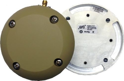
GPS Source has released a new GNSS antenna that is robust, lightweight, and suitable for harsh environments. It is designed for long-term, high-precision applications worldwide, the company said.
The antenna was engineered for the demanding aviation environment, in both commercial and military applications. Built to military standards (MIL-STD), it is impact resistant, tolerant of exposure to dust, chemicals and jet fuels, and has the ability to withstand shock and vibration.
Signal reception is unaffected by antenna placement. Designed to operate in the most extreme and demanding applications, it gives outstanding results, enabling maximum satellite reception, with ultra-low Dilution of Precision (DOP), GPS Source said.
“We are very excited about the new GNSS antenna,” said Robert Horton, CEO of GPS Source. “Our advanced technology provides superior performance in both GPS L1/L2 and GLONASS L1/L2. This is the best solution for technically demanding users.”
The antenna is available in multiple colors and with multiple connector options.