The Trimble Geo 7 series of rugged, high-accuracy GNSS handhelds will have RTX correction. Photo: Trimble
Trimble’s RTX technology-based correction services — Trimble CenterPoint RTX, Trimble RangePoint RTX, and the new Trimble ViewPoint RTX — will be available for Trimble Geo 7X handhelds. Trimble made the announcement at Trimble Dimensions.
Trimble RTX technology provides compatible GNSS receivers with correction services that significantly improve accuracy and reliability in obtaining positions worldwide. Geospatial professionals now have more flexibility to achieve the accuracy required by their highly mobile workflows in real-time, without being tied to a base station or local VRS network, Trimble said.
Available worldwide through an IP connection where cellular communication is available, Trimble RTX offers geospatial professionals flexibility in where and when they are able to work. Operational efficiency and productivity in the field is improved by delivering real-time DGNSS corrections directly to the Trimble Geo 7X handheld. Field challenges, such as obstructed satellites and inaccessible locations, are also minimized with Trimble Floodlight and Trimble Flightwave technology options for the Trimble Geo 7X.
The handheld solution is designed for a variety of industries — such as utility companies, municipalities, and environmental management agencies — in which workers are highly mobile and require a reliable, flexible data-collection and asset management solution.
“We have eliminated the complexities of managing multiple correction sources across a large geographically dispersed project or organization,” said Alain Samaha, business area director of GIS and Software for Trimble’s Geospatial Division. “By offering RTX-based correction services, we simplify their work and deliver the accuracy that our customers require.”
A choice of RTX correction services ranging from 4 centimeters to submeter-level horizontal accuracies is available. Customers can choose the appropriate Geo 7X handheld configuration with the RTX-based correction service that meets the accuracy level and capability required for their job.
KCS BV has launched a new tiny tracker, the TM-202LAR. It’s the newest addition to the KCS family of TraceME products. The KCS GPRS/GPS range of modules enable users to remotely track and trace people, animals and a variety of objects, such as vehicles, containers, motorcycles, lawn mowers, or other valuable assets.
KCS TraceME TM-202LAR is targeted for personal use, or any other application that needs a small size with long battery life while still featuring the options and server connection that full-size units have.
The TraceME TM-202LAR is KCS’s smallest full featured GPS tracker at 46 x 21 x 6.5 mm, weighing 7 grams. Other features and options include:
GPS, RF and GSM antennas
advanced power saving, down to 2.5µA
10 years of operation from one Lithium C-Cell
RF connectivity, up to 2 km
location-based positioning (LBS/Wi-fi/GPS)
onboard sensors for compass, temperature, acceleration
LandWorks, Inc., a developer land management solutions, has added individual parcel polygons to its cloud-based offering of GIS-ready map products. Clients can now search, purchase and download digital parcel data sets with related attributes directly from the LandWorks website — in orders as small as a single parcel — at a cost of $2 per parcel.
LandWorks developed the online parcel purchase application for industries and professions that need up-to-date surface land ownership information in their GIS. Some of the sectors already taking advantage of LandWorks’ online offerings include utilities, oil and gas, pipelines, real estate, banking, departments of transportation, renewable energy and mining.
“The main benefits of buying parcel data from the LandWorks website are affordability and instant access,” said LandWorks President Jerry Bramwell. “Until now, digital map users had to order parcel polygon products by the county and then wait two to three weeks for delivery.”
On the LandWorks website, there is no minimum or maximum purchase limit. The customer simply logs onto the parcel data page and searches for the desired parcel or parcels. The user may graphically select the desired parcels by searching and clicking on a map display or by uploading a spreadsheet containing the county tax parcel ID numbers.
“The online database accessed through the LandWorks website contains parcel data for most of the United States,” said Bramwell. “This data comes from county assessor files or is manually digitized from paper plats and is updated quarterly.”
The LandWorks site keeps track of desired parcels during the search process. When the user is ready, the website reports the number of parcels that have been selected and their total cost calculated at $2 per parcel. The user can add or delete parcels as desired. The user then decides to purchase the parcel polygons in either NAD 27 or NAD 83 map datum. Prior to purchase, the site gives the user the option of receiving the digital data sets in Esri shapefile or file geodatabase format. Each parcel polygon is delivered with key attributes — parcel number, parcel address, owner name/address, and official legal description.
The digital parcel polygons come ready for download directly into Esri ArcGIS software as well as other popular mapping systems such as IHS Petra, IHS Kingdom and LMKR GeoGraphix.
Ricoh Americas Corporation has made major improvements to its water-, dust- and shock-resistant G800 camera. The G800SE model includes GPS and a barcode-reading capability that helps streamline workflows across a wide range of industries.
The new Wi-Fi- and Bluetooth-enabled Ricoh G800SE allows for dynamic information capture in industries such as automotive, logistics, government, healthcare, emergency services and more. For example, a car dealership can scan the barcode on a new car, photograph the vehicle, and have the photograph and vehicle information flow directly to the dealership website for customers to see. This new workflow saves hours of painstaking information retrieval and organization, Ricoh said. With a standard camera, clerks would need to manually match images to each car, introducing the possibility of error at every step.
“By embedding critical data into images, the Ricoh G800SE epitomizes information mobility, the ability for employees to access just the information they need in the form they need it to make important decisions,” said Matt Sakauchi, vice president, Technology Marketing, Ricoh Americas Corporation. “This is just one way we’re making customers’ business information work for them in this new world of work.”
The Ricoh G800SE includes a host of upgrades over the previous generation of ruggedized Ricoh wireless-enabled camera, the Ricoh G700SE. For example, a higher-resolution image sensor provides a new ability to capture images under low-light conditions. The Ricoh G800SE also takes advantage of higher wireless transmission speeds and the more secure “enterprise” Wi-Fi increasingly seen in healthcare facilities and government agencies. It leverages the Protected Extensible Authentication Protocol (PEAP), an emerging standard in enterprise wireless security.
A flexible password lock feature enables organizations to create separate passwords for administrators and users with each one unlocking different sets of permissions. A smartphone connection enables users to remotely operate the camera via their mobile devices. Using a smartphone or tablet, they can preview, zoom, shoot and capture image data, including GPS position. The capability is also intended for surveillance applications.
Organizations can manage fleets of Ricoh G800SE cameras via remote management software with the ability to upgrade firmware, adjust camera settings and update memo functions. An alternative for camera configuration is distributing SD cards with prescribed settings.
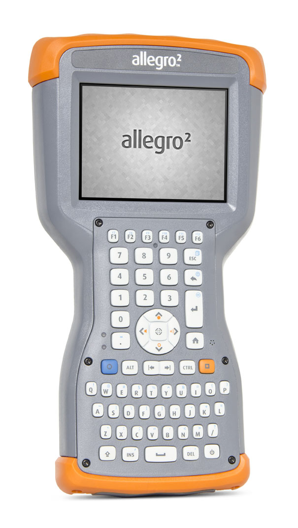
The Allegro 2 by Juniper Systems. Photo: Juniper Systems
Juniper Systems announced its newest rugged handheld computer, the Allegro 2, at the InterGeo 2014 trade show, held September 7-9 in Berlin. The handheld is the latest in the company’s Allegro product line, “with every bit of reliability,” the company says, but now with some major advancements.
According to Juniper Systems, the Allegro 2 was designed for data-intensive applications, with meticulous attention paid to the engineering and design of the handheld to maximize efficiency and precision, both of which are critically important to high-volume data collection.
Compared to the Allegro 1, the Allegro 2 has a newly designed keyboard in a QWERTY and numeric layout, with large, glove-friendly buttons for rapid — even non-visual — data entry. The new handheld features a custom Sun-to-Shade display that is 20 percent larger than the previous Allegro. It offers excellent visibility in any lighting conditions, the company said.
The Allegro 2 is powered by an Overtime Technology battery, providing a 20+ hours of runtime. Its touchscreen uses capacitive technology, providing excellent durability, as well as crystal-clear imagery and greater sensitivity to touch, Juniper Systems said. The Allegro 2 has significantly enhanced GNSS performance, extended Bluetooth range, camera and video options, and a more powerful processor than the Allegro 1.
“The Allegro 2 is our next-generation product, and it includes all of the latest enhancements available in its sister product, the Archer 2,” said John Florio, product manager at Juniper Systems. “The Allegro 2 was built from the ground up, based on user feedback on the jobs they have to do. Whether the customer is grading lumber in a log scaling yard, running a robotic total station, or performing a close-interval pipeline survey, the Allegro 2 is the best solution for the field today.”
The Allegro 2 is scheduled to begin shipping in November.
Sokkia announces the latest addition to its line of geodetic GNSS reference receivers — the GNR5. Making use of 452 channels optimized to track the full GNSS spectrum, the GNR5 is designed to assign any visible signal to any available receiver channel.
“The GNR5 is a comprehensive connectivity solution,” said Charles Rihner, vice president of the GeoPositioning Group. “Whether using the built-in Bluetooth and Wi-Fi wireless communication options, or standard Ethernet, serial and USB connections — the system provides a powerfully integrated reference station that is capable of tracking the GPS, GLONASS, Galileo, Beidou, QZSS and SBAS constellations.”
Additional features include high-precision code and carrier phase measurements up to 100 Hz, Power over Ethernet (PoE), and advanced receiver management features.
The new receiver is on display at InterGeo 2014, being held this week in Berlin.
Altus Positioning Systems, a Septentrio company, has integrated its APS-GeoPod product with Entegra Technologies’ Crossfire Pro Tablet. This collaboration, targeting the oil and gas, survey, GIS and transportation industries, provides a high-performance tablet-based solution for enabling ultra-precision RTK of sub-meter or centimeter accuracy.
Altus is showcasing the APS-GeoPod and Crossfire Pro tablet, along with the full range of Altus products, at booth A1.060 and outside Booth FG.006 at InterGeo 2014 being held this week in Berlin, Germany.
According to Altus CEO Neil Vancans, the Altus APS-GeoPod and the Entegra Crossfire Pro Tablet provide a combination of precision, performance and features that make it ideal for energy services, land surveys and other GIS-related applications.
APS-GeoPod is a compact GPS/GLONASS RTK and DGNSS receiver that adds high-precision RTK positioning to USB-compatible tablet PCs. “This unique product gives users the convenience of adding RTK precision to any on-board application on mobile devices geared to the field service professional,” Vancans said.
The Entegra Crossfire Pro tablet. Photo: Altus Positioning Systems
APS-GeoPod features include:
Compact dual-frequency GNSS module
Low power consumption (<1 Watt)
USB 2.0 interface
Internal L1 GPS/GLONASS antenna
NMEA integration with GIS software
The Crossfire Pro tablet features the multi-touch interface and communication capabilities of smartphones, the large display and ergonomics of consumer tablets, and the daylight-readable screen and durability of rugged tablets. Safety features include UL 1604 Class I/Division II certification for operation in hazardous locations. To users, Crossfire Prodelivers a customizable tablet for exacting daily activities, resulting in greater efficiencies, response times, productivity and customer service levels, the companies said.
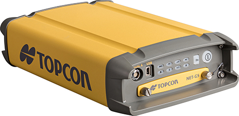
Topcon’s NET-G5 receiver and CR-G5-C antenna. Photo: Topcon
Topcon Positioning Group announces the next generation of its geodetic GNSS reference receivers and antennas — the NET-G5 receiver and CR-G5-C antenna.
The announcement was made at InterGeo 2014, being held this week in Berlin.
Using Vanguard and Universal Tracking technologies, the NET-G5 receiver incorporates 452 channels capable of tracking the full GNSS signal spectrum, including modernized GPS, GLONASS, Galileo, Beidou, QZSS and SBAS signals. Universal Tracking has the advantage and capability to assign any visible GNSS signal to any available receiver channel.
The NET-G5 receiver is designed to work as a complete system connectivity solution, with built-in Bluetooth and Wi-Fi, for flexible wireless communications or via standard Ethernet, serial and USB connections. Other features include: High-precision code and carrier phase measurements up to 100 Hz; Power over Ethernet (PoE) and an all new Topcon receiver web interface with advanced receiver management features.
“Comprehensive communication support, advanced web-server capability, and extended operating times are among the new features supported on the NET-G5. Coupled with the CR-G5-C antenna, the new systems provides a powerful, interference protected network solution,” said Charles Rihner, vice president of the Topcon GeoPositioning Group.
“Whether you are installing an all-new GNSS network infrastructure, expanding or upgrading an existing network, looking for a premium campaign receiver or stand-alone RTK base station, the high-performance NET-G5 is designed to provide the most advanced reference station solution available in the market,” Rihner said.
The CR-G5-C is a full-wave geodetic choke-ring antenna designed to address evolving requirements for reference networks and infrastructure monitoring applications. “The CR-G5 antenna has excellent vertical phase center stability over the entire GNSS frequency band, providing superior performance in tracking low elevation satellite signals,” Rihner said. “This new model employs cavity filter technology to more aggressively combat radio frequency interference in difficult environments.”
Spectra Precision introduced a new cloud computing service for Spectra Precsion applications. The company also announced new road modules for version 5.5 of its Survey Pro software and for Spectra Precision Survey Office.
The announcements were made at InterGeo 2014, being held this week in Berlin.
Spectra Precision Central is a new cloud computing service. Photo: Spectra Precision
Spectra Precision Central. A dedicated cloud computing service for Spectra Precision survey applications, Spectra Precision Central offers survey teams in the field and office the ability to rapidly exchange survey and project data with team members when and where it is needed.
“Spectra Precision Central is a straightforward and uncomplicated solution that offers significantly improved data management efficiency for virtually any size land survey firm,” said Olivier Casabianca, Spectra Precision business area director. “Field crews can store project data to a Central account in the cloud using a data collector with Survey Pro, a connected computer or most smartphones and have the data immediately available to other work groups in the field or office. All data is synchronized for either online or offline use by any connected office computer and data collector.”
As part of the Spectra Precision Central service, users can download Survey Pro Central, a free smartphone app, which enables iOS and Android devices to connect directly to the Spectra Precision Central system. Survey Pro Central provides another easy way to access documents, upload and download files, and manage survey data. Survey Pro Central also supports a coordinate viewer, a raw data viewer, and a map display that can also use Google maps. Whatever sensor is being used, a total station or GNSS receiver, the Spectra Precision Central system provides the hub to permit crews to transfer and share data through their Central cloud account.
A one-year Spectra Precision Central license is included with the purchase of any model Spectra Precision data collector with Survey Pro. Each Central account can have as many users and logins as the business requires. Maintaining the Survey Pro extended warranty annually automatically renews the license. Data in the account is always available, even if the subscription expires, by simply synchronizing the data in the Central cloud to the office computer.
Survey Pro Version 5.5. Spectra Precision Survey Pro version 5.5 now includes a new road module and integration with Spectra Precision Central. Survey Pro version 5.5 is the latest release in 20 years of continuous development.
Survey Pro version 5.5 is fully integrated with the new Spectra Precision Central cloud system. Files can be automatically or manually synchronized to the cloud which then synchronizes data back to the office or smart phones. This new feature provides access to a user’s data whenever they need it and provides an off-site backup service for valuable data.
The new road module is used for importing, managing, and staking roads. The module directly supports the data from the new version of Spectra Precision Survey Office. Now roads can be designed in Survey Office, exported to Survey Pro on the data collector, and staked in the field providing a complete system. The new system includes a number of improved and enhanced features as well as new graphic and data views.
Other features include a new GNSS interface to improve workflows, a new multi-point backsight setup routine, and many other enhancements.
The new version will be available for all customers who are current with a maintenance plan. Customers who are not current can purchase a new maintenance plan to get the latest updates including a Spectra Precision Central account.
Spectra Precision Survey Office. Spectra Precision Survey Office (SPSO) now includes support for advanced roading that allows for allows for the creation, import, export and edit of corridors and roads.
The new roading module allows users to create cross-sections, create points at intervals, add in material layers and the ability to create and edit templates. This allows for the integration of Survey Pro field software and SPSO office software for a complete solution.
In addition to roading, the SPSO software now includes traverse adjustment, importing of Esri Shapefiles, additional geoid modules, smooth curve feature code and import and export functionality for FAST survey job files.
Trimble introduced several new products at InterGeo 2014, being held this week in Berlin, with a focus on incorporating data from photographs and imagery into geospatial databases.
Trimble also offered an expanded GNSS portfolio for surveyors that includes the Trimble NetR9 Geospatial receiver; the Trimble Geo7X with Trimble Access field software onboard; and enhanced Trimble xFill functionality that provides continuous RTK level accuracy when paired with a Trimble CenterPoint RTX subscription. The new additions offer surveyors more flexibility in the field to meet a variety of work requirements. Learn more here.
Photo: Trimble
Inpho version 6.0. Trimble announced a new version of its photogrammetric software suite, which provides highly automated workflows for photogrammetry and remote sensing professionals so they can process thousands of airborne images with high precision. Inpho version 6.0 increases efficiency by reducing project turnaround times and improves the quality of deliverables via new automated and interactive tools and satellite triangulation functionality.
A new satellite triangulation function in Inpho version 6.0 allows professionals to quickly generate deliverables from satellite imagery data and expand their capabilities, addressing the needs of industries such as environmental, forestry, agriculture and land management. Automatic tie point extraction and bundle block adjustment provides improved orientation of satellite images. The highly automated process results in a significant reduction in office processing time so projects can be delivered with quality precision in a shorter turnaround time.
Photo: Trimble
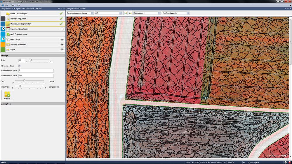
eCognition Essentials. eCognition Essentials is a new software solution for geospatial and remote sensing professionals performing land-cover mapping tasks using satellite imagery. eCognition Essentials offers an intuitive image analysis solution that allows users of all levels to quickly produce high-quality, Geographic Information System (GIS)-ready deliverables.
Leveraging core eCognition software technology, eCognition Essentials is easy to use with its simplified and intuitive interface. eCognition Essentials reduces analysis error as it applies predefined and structured rules to analyze and transform imagery data into relevant geospatial information. The new automated image analysis functions — such as image segmentation or sample-based classification — combined with a set of interactive tools for quality control offer users a streamlined workflow for quicker project turnaround times.
Trident version 7.0 is a new version of the mobile data analysis software designed to efficiently manage, interpret and extract features from digital images and point cloud data collected via land mobile systems. Enhancements in the new version significantly reduce the time required for geospatial professionals to transform land mobile sensor data into relevant geospatial information used in civil engineering, transportation and GIS mapping. In these applications, Trimble Trident can be used for surface modeling, roadway sign and pole detection, lane marking detection, edge and breakline detection, road geometry and clearance measurements.
Trident version 7.0 offers increased automation functionality to deliver results more quickly. Updated feature extraction tools within the software provide greater reliability and minimize manual editing and verification. Trident version 7.0 breakline detection routines now include a cross-sectional workflow for rapid and progressive development of supervised roadway breakline models.
Photo: Trimble
Trimble V10 Imaging Rover. The Trimble V10 is an integrated camera system that precisely captures 360-degree digital panoramic images for visual documentation and measurement of the surrounding environment. Enhancements include additional integration options and high-dynamic range (HDR) imagery. The Trimble V10 offers an accessible and efficient means of visually documenting site conditions to perform measurements in the office, produce more powerful deliverables and speed up decision making for managers on or off the site.
In addition to the R10 GNSS receiver, the Trimble V10 Imaging Rover now seamlessly integrates with Trimble’s R-Series GNSS receivers — the Trimble R8, R6 and R4 — and TSC3 controller. Through this seamless integration, geospatial professionals can easily capture high-quality, geo-referenced panoramic images to document the surroundings. Now more Trimble customers can take advantage of the Trimble V10’s powerful capabilities. In addition, a new two-piece power rod option enables easy transportation of the Trimble V10.
Sokkia has released the the NET AXII, the latest in its line of high-accuracy measuring stations. Designed for precision-intensive tasks such as monitoring, bridge construction, and other highly detailed engineering projects, the NET AXII series is a fully robotic total-station solution.
The series includes the NET1 AXII and the NET05 AXII with 1-inch angle accuracy and 0.5-inch angle accuracy, respectively. “NET1 AXII is an excellent choice for long distance measurements, and NET05 AXII is a powerful solution for high-accuracy survey and construction projects,” said Brice Walker, vice president of survey sales.
“These fully robotic models offer a superior level of performance compared to conventional systems that simply lock on to the nearest targets, Walker said. “The NET AXII auto-collimation system allows the measuring station to lock on to targets that are closest to the center view of the telescope, providing long-range precision even in low-light conditions. Additionally, the exclusive Reflector Prescan technology dramatically improves setup efficiency by automatically locating approximate reflector positions, even in situations where they cannot be seen by the human eye.”
Features include Bluetooth connectivity options, an IP65 durability rating, and TSshield security and maintenance.
Topcon Positioning Group announces an update to its world’s first line of 3D positioning systems designed for one-operator layout — the LN-100W. The latest model includes Bluetooth functionality.
The LN-100W is on display at InterGeo 2014, being held this week in Berlin.
“LN-100W offers an enhanced level of connectivity with the addition of Bluetooth functionality,” said Ray Kerwin, Topcon director of global surveying products. “Now operators have an additional wireless communication option that will provide greater versatility with devices such as tablets that might not be WLAN ready.
“The update exemplifies our focus on making the LN-100 as simple to use as possible,” said Kerwin. “The LN-100W offers the popular self-leveling, one-operator 3D layout features of the original model, and takes the ease-of-use a step further.”
The LN-100W is the newest of BIM (Building Information Modeling) solutions from Topcon.