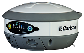
The Carlson BRx5 GNSS receiver, an integrated all-in-one pole-top GNSS receiver, has just been released by Carlson Software, Inc. Each BRx5 contains a multi-constellation, multi-band 270-channel GNSS receiver, internal GSM cell modem, UHF radio, dual hot-swappable batteries and internal level sensors. Designed for survey and GIS professionals, the Carlson BRx5 delivers both affordability and the highest positional accuracy, the company said.
“Carlson’s exclusive LDL (live digital level) feature in SurvCE 4.0 uses the BRx5’s internal level sensors to provide electronic leveling for better x,y accuracy as you work,” said Bruce Carlson, president of Carlson Software. “In addition, it holds fix under canopy better than most GPS systems currently on the market.”
Manufactured to Carlson’s exacting specifications by Hemisphere GNSS, the BRx5 receivers can each be configured as base, rover, or network rover. They come with dual Bluetooth ports, allowing users to connect both data collector and a cell phone, and they each come with a fully integrated multi-constellation dual frequency GNSS receiver with UHF radio and GSM cell modem.
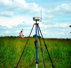
SurvCE 4.0 allows high positional accuracy with the BRx5′s integrated level sensors.
Designed for use by surveyors, contractors, builders, engineers and many others, the BRx5 can be purchased as either a Rover or as a Base/Rover package. The Base/Rover package includes two BRx5 GNSS receivers, one hard-sided carrying case, four BRx5 batteries with two chargers, one GPS tribach and one tribach adapter, and two Carlson GPS receiver poles.
With its dual hot-swap batteries, there’s no need to stop work to recharge or replace battery packs. In addition, the BRx5 is OmniSTAR-capable with submeter differential correction available worldwide.
The Carlson BRx5 GNSS receiver is designed to work seamlessly with most data collectors including Carlson’s rugged and popular data collectors: the Carlson Surveyor+, the Carlson MINI2, and the Carlson Supervisor.
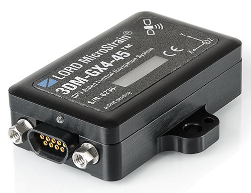
The 3DM-GX4-45 by LORD MicroStrain is a miniature, industrial-grade GPS-aided inertial navigation system that uses high-performance MEMS sensor technology. It combines a triaxial accelerometer, triaxial gyro, triaxial magnetometer, temperature sensors, pressure altimeter, and dual on-board processors running a sophisticated Extended Kalman Filter (EKF) to provide excellent position, velocity, and attitude estimates.
It offers a range of fully calibrated AHRS measurements, including acceleration, angular rate, magnetic field, deltaTheta and deltaVelocity vectors. GPS measurements include LLH position, ECEF position and velocity, NED velocity, UTC time, GPS time, and SVI. The receiver is a 50-channel u-blox 6, which receives GPS L1 C/A code, and the SBAS signals WAAS, EGNOS, and MSAS.
The 3DM-GX4-45 provides accurate navigation and orientation under dynamic conditions for applications such as GPS-aided navigation; unmanned vehicle navigation; camera stabilization; robotic control; and reconnaissance, surveillance, and target acquisition.
Topcon Positioning Group has released the latest edition to the MS line of high-precision total stations in the North and South American markets. The MS AXII measuring station series is designed for precision-intensive tasks, such as monitoring, bridge construction, and other highly detailed engineering projects.
The series includes the MS1 AXII with 1-inch angle accuracy, and the MS05 AXII with 0.5-inch angle accuracy. “The MS1 AXII is perfect for long-distance measurement activities, while the MS05 AXII is built for high-accuracy survey and construction projects,” said Ray Kerwin, Topcon director of global surveying products.
“The fully robotic MS AXII models are vastly superior to conventional systems that simply lock on to the nearest targets,” said Kerwin. “The MS AXII auto-collimation system allows the instruments to lock on to targets that are closest to the center view of the telescope, providing long-rage precision and accuracy even in low-light conditions.”
Additional features include integrated Bluetooth connectivity options, durability with an IP65 rating, and TSshield technology for security and maintenance.
Spatial Wave, Inc., has announced that its latest releases, Mapplet, Field Mapplet, and MapLibrary are now compatible with Esri’s latest version of ArcGIS 10.2. New customers and existing customers on maintenance will receive the new release.
Mapplet is an advanced GIS viewer for viewing utility operational data that has unique capabilities to link to external data sources. Mapplet uses the latest ArcGIS technology for setup and configuration purposes and takes advantage of Arcgis.com base maps to enrich the experience of the users that are using map services from ArcGIS.com platform.
Field Mapplet is an advanced mapping and GIS-enabled framework designed to optimize utility workflows with an easy-to-use and implement solution. Field Mapplet takes advantage of ArcGIS Version 10.2 and includes a map-centric user interface. These new enhancements help bring together field and office workers, which in turn streamlines the daily workflow processes between crews, supervisors, and management.
MapLibrary is being further enhanced with support for displaying map services from ArcGIS Server 10.2 or ArcGIS.com platform depending on the choice of users.
Through the use of many powerful components, Mapplet, Field Mapplet and MapLibrary are designed for both utilities and local government agencies interested in developing GIS portals and maintaining geographic assets without additional programming.
2014 USGS National Seismic Hazard Map, displaying intensity of potential ground shaking from an earthquake in 50 years (which is the typical lifetime of a building).
To help make the best decisions to protect communities from earthquakes, new USGS maps display how intense ground shaking could be across the nation.
The USGS recently updated its U.S. National Seismic Hazard Maps, which reflect the best and most current understanding of where future earthquakes will occur, how often they will occur, and how hard the ground will likely shake as a result.
42 States at Risk; 16 States at High Risk
While all states have some potential for earthquakes, 42 of the 50 states have a reasonable chance of experiencing damaging ground shaking from an earthquake in 50 years (the typical lifetime of a building). Scientists also conclude that 16 states have a relatively high likelihood of experiencing damaging ground shaking. These states have historically experienced earthquakes with a magnitude 6 or greater.
The hazard is especially high along the west coast, intermountain west, and in several active regions of the central and eastern U.S., such as near New Madrid, Missouri, and near Charleston, South Carolina. The 16 states at highest risk are Alaska, Arkansas, California, Hawaii, Idaho, Illinois, Kentucky, Missouri, Montana, Nevada, Oregon, South Carolina, Tennessee, Utah, Washington, and Wyoming.
While these overarching conclusions of the national-level hazard are similar to those of the previous maps released in 2008, details and estimates differ for many cities and states. Several areas have been identified as being capable of having the potential for larger and more powerful earthquakes than previously thought due to more data and updated earthquake models. The most prominent changes are discussed below.
Students conduct the “drop, cover, hold on” safety procedure during an earthquake preparedness drill. Photo Credit: Jessica Robertson, USGS
Informed Decisions Based on the Maps
With an understanding of potential ground shaking levels, various risk analyses can be calculated by considering factors like population levels, building exposure, and building construction practices. This is used for establishing building codes, and in the analysis of seismic risk for key structures. This can also help in determining insurance rates, emergency preparedness plans, and private property decisions such as re-evaluating one’s home and making it more resilient.
These maps are part of USGS contributions to the National Earthquake Hazards Reduction Program (NEHRP), which is a congressionally-established partnership of four federal agencies with the purpose of reducing risks to life and property in the U.S. that result from earthquakes. The contributing agencies are the USGS, Federal Emergency Management Agency (FEMA), National Institute of Standards and Technology, and National Science Foundation (NSF). As an example of the collaboration, the hazards identified in the USGS maps underlie FEMA-sponsored seismic design provisions that are incorporated into building codes adopted by states and localities. The maps also reflect investments in research by academic and other scientists supported by grants from the USGS and the NSF.
“The standards for seismic safety in building codes are directly based upon USGS assessments of potential ground shaking from earthquakes, and have been for years,” said Jim Harris, a member and former chair of the Provisions Update Committee of the Building Seismic Safety Council.
“The committees preparing those standards welcome this updated USGS information as a basis for making decisions and continuing to ensure the most stable and secure construction.”
Key Updates
East Coast
The eastern U.S. has the potential for larger and more damaging earthquakes than considered in previous maps and assessments. As one example, scientists learned a lot following the magnitude 5.8 earthquake that struck Virginia in 2011. It was among the largest earthquakes to occur along the east coast in the last century, and helped determine that even larger events are possible. Estimates of earthquake hazards near Charleston, SC, have also gone up due to the assessment of earthquakes in the state.
Damage to the Washington National Cathedral in DC from the earthquake in Virginia on August 23, 2011. Photo Credit: William Leith, USGS
In New York City, the maps indicate a slightly lower hazard for tall buildings than previously thought (but still a hazard nonetheless). Scientists estimated a lower likelihood for slow shaking from an earthquake near the city. Slow shaking is likely to cause more damage to tall structures in contrast, compared to fast shaking which is more likely to impact shorter structures.
Central U.S.
The New Madrid Seismic Zone has been identified to have a larger range of potential earthquake magnitudes and locations than previously identified. This is a result of a range of new research, part of which was recently compiled by the Nuclear Regulatory Commission.
West Coast
In California, earthquake hazard extends over a wider area than previously thought. Most notably, faults were recently discovered, raising earthquake hazard estimates for San Jose, Vallejo and San Diego. On the other hand, new insights on faults and rupture processes reduced earthquake hazard estimates for Irvine, Santa Barbara and Oakland. Hazard increased in some parts of the San Francisco Bay Area and Los Angeles region and decreased in other parts. These updates were from the new Uniform California Earthquake Rupture Forecast Model, which incorporates many more potential fault ruptures than did previous assessments. Recent earthquakes in Alaska, Mexico and New Zealand taught scientists more about complex ruptures and how faults can link together. This insight was applied to California for which approximately 250,000 potential complex ruptures were modeled.
New research on the Cascadia Subduction Zone resulted in increased estimates of earthquake magnitude up to magnitude 9.3. Deep-sea cores were collected that show evidence within the sea-floor sediments of large earthquake-generated mudflows. Earthquake shaking estimates were also increased following abundant data gathered from the magnitude 9.0 earthquake in Tohoku, Japan in 2011 and the magnitude 8.2 earthquake offshore of Chile in 2014, as those events ruptured along subduction zones similar to the Pacific Northwest zone.
In Washington, scientists incorporated new knowledge of the Tacoma Fault into the maps and identified changes to the geometry of the Whidbey Island fault in the northern Puget Sound. Earthquake hazard also increased for Las Vegas because of new science. In Utah, scientists dug trenches to study prehistoric earthquakes along the Wasatch Fault. While the overall seismic hazard didn’t change significantly, detailed changes were made to the fault models in this region and robust data were acquired to hone the assessments. This is valuable since approximately 75% of Utah’s population, including the residents of Salt Lake City, lives near this fault.
The magnitude 7.9 earthquake in Wenchuan, China in 2008 provided many new records of shaking that are very similar to anticipated future earthquakes in the western U.S., as the fault structures are similar. Previously, scientists did not have nearly as many shaking records from earthquakes of this size.
Induced Earthquakes — Research Underway
Some states have experienced increased seismicity in the past few years that may be associated with human activities such as the disposal of wastewater in deep wells.
One specific focus for the future is including an additional layer to these earthquake hazard maps to account for recent potentially triggered earthquakes that occur near some wastewater disposal wells. Injection-induced earthquakes are challenging to incorporate into hazard models because they may not behave like natural earthquakes and their rates change based on man-made activities.
Topcon Positioning Group has added a cellular modem option for the HiPer SR for GIS receiver.
“The integrated modem provides greater functionality for the HiPer SR,” said Jason Hooten, Topcon GIS national sales manager. The unit can now be used as a cellular base station through the MAGNET® Relay option. In addition, the cellular feature allows the receiver to provide a connection to existing data collectors that do not contain internal cellular modems.
“With the new cellular modem and HSPA (High Speed Packet Access), the receiver not only enables users to easily obtain Spectrum-RTK (Real Time Kinematic) and RTK corrections via the Internet, it also allows it to function as a mobile base station as part of the MAGNET Relay GIS broadcasting service, ‘relaying’ corrections to multiple rovers,” Hooten said.
“The multiple configuration options make the compact and lightweight HiPer SR extremely versatile for any GIS user,” said Hooten.
Additional features of the HiPer SR for GIS include 226-channel Vanguard technology with Universal Tracking Channels and Fence Antenna® technology for signal tracking sensitivity and multipath rejection.
Topcon Positioning Group has added the MAGNET Relay for GIS to its suite of cloud-based solutions software. As a component of MAGNET Field GIS, MAGNET Relay GIS is a mobile base station real-time kinematic (RTK) broadcasting service. The system is designed to allow subscribers to connect a GNSS base receiver to MAGNET Relay via a cellular connection for high-accuracy RTK corrections.
“The RTK base station can be used by up to 10 rovers, which makes MAGNET Relay a great solution for large scale and highly precise GIS projects,” said Jason Hooten, Topcon national sales manager for GIS products.
“MAGNET Relay for GIS allows for data to be collected in the field without the need for post processing, and then quickly transferred to the office using the company’s secure, cloud-based MAGNET Enterprise account,” Hooten said. “Additionally, the service brings real-time network-based corrections to project sites that do not have existing coverage.”
Scene Sharp USA has introduced its Fuze Go Plugin for ENVI this week at the Esri User Conference in San Diego. The plugin gives ENVI software users access to Fuze Go MS Sharp, an automated multispectral image fusion software that can simultaneously fuse up to 30 spectral bands of data from inside the ENVI geospatial processing package.
“The Exelis ENVI software is widely known for its multi- and hyperspectral image processing capabilities and is an ideal platform for geospatial information users to access the automated Fuze Go MS Sharp image fusion software,” said Ian Lucas, President and CEO of Scene Sharp Technologies Incorporated.
Scene Sharp is demonstrating the Fuze Go plugin along with the full line of Fuze Go software products in booth #410 at the Esri User Conference being held July 14-18 in San Diego.
The plugin gives users the option of accessing the Fuze Go MS Sharp software either within the ENVI workflow or outside of it so that fusion can be performed as a stand-alone application. This frees up the ENVI software license for other image processing activities. No GIS or image processing experience is needed to utilize the Fuze Go tools.
Fuze Go is a fully automated technology that enables users to quickly and easily fuse data sets to add color to non-colorized satellite and aerial imagery with just a few mouse clicks. One of its most common applications is pan-sharpening. By colorizing image data, GIS users can visualize and extract richer information content from remotely sensed data to make better informed decisions.
Also at the 2014 Esri UC, Scene Sharp USA is demonstrating the processing capabilities in its Fuze Go SAR Sharp application, which was designed for more effective exploitation of data captured by satellite-based synthetic aperture radar (SAR) sensors. Fuze Go SAR Sharp fuses gray-scale radar data with optical multispectral bands to colorize the SAR data set. The Dynamic Reader allows pre-process on-the-fly viewing of SAR imagery with real-time adjustment of color intensity being added to the scene.
Fuze Go MS Sharp and SAR Sharp are available for purchase for an annual license fee. Batch processing versions of the software packages are also offered to perform automatic fusion of multiple optical or SAR scenes.
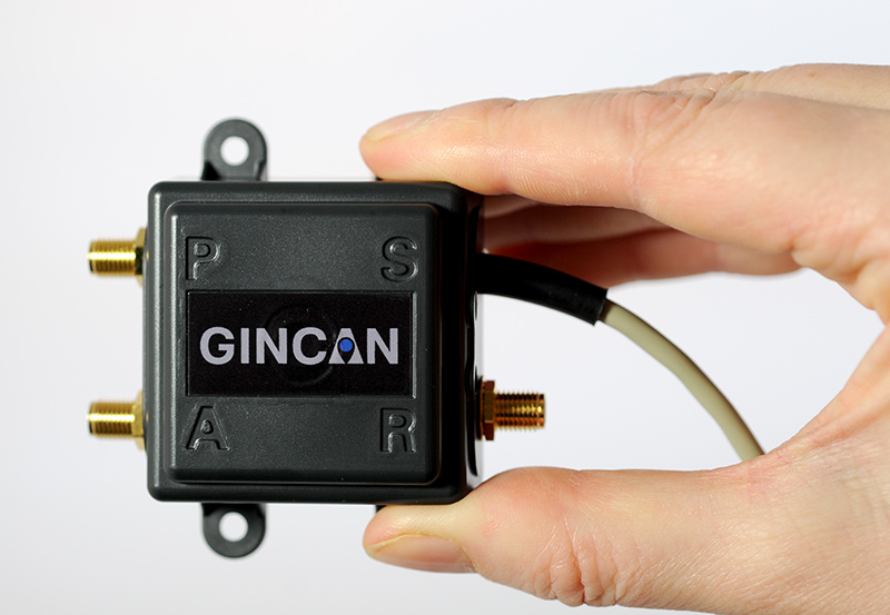
Chemring Technology Solutions has developed miniaturized GPS anti-jamming technology it has dubbed GINCAN. GINCAN is designed to combat illegal GPS jammers and is based on the adaptive antenna concept used by military systems. GINCAN has a chip footprint of six millimeters squared.
GINCAN’s reduced size and weight will significantly cut power usage and cost, the company said, making it ideal for combatting the widespread problem of low-powered GPS jamming. GINCAN can be integrated into a range of applications, including in-vehicle satellite navigation systems and cellular technology, and can be used for the protection of the critical infrastructures which rely on GPS to provide positioning and timing.
GPS jammers have already been developed to interfere with the European Union’s Galileo system, which will provide European satellite navigation independently from the Russian, USA and Chinese systems by 2019. Chemring Technology Solutions, based in Romsey, England, has anticipated this problem and its GPS anti-jamming technology will also support systems using Galileo.
Once the preserve of the military, there is now an increasing demand for GPS protection in the civilian market as illegal GPS jamming equipment becomes widely available on the Internet. The £1.5 million government-funded Sentinel project, designed to measure GPS jamming on UK roads, recorded more than 60 individual jamming incidents across six months at a single location. Such attacks could seriously impact industries, including maritime, aerospace, the emergency services and even stock market trading.
“Many years of developing GPS protection technology for the military has enabled our research and development team to miniaturize anti-jamming technology,” said Martin Ward, product manager, Chemring Technology Solutions. “GINCAN can now be easily integrated in to a range of applications to provide effective protection against jamming devices.
“As we become increasingly reliant on GPS technology, and low-cost jammers are proliferating, so a potential time bomb is being created. Chemring Technology Solutions is now able to offer the answer to this problem with jammer protection at a reduced size, weight, power and cost footprint.”
GINCAN is an export controlled product and subject to UK export restrictions.
CoreLogic, a global property information, analytics and data-enabled services provider, has introduced a new land records management solution to provide a single source of location information and property characteristics data for the oil & gas, utilities and telecommunications industries. SpatialRecord by CoreLogic integrates CoreLogic parcel-level spatial data with the company’s vast property-level database to provide expanded data analysis and more granular information.
The patented technology used to create SpatialRecord technology converts raw data into easily digestible information that can be leveraged to make more informed exploration, planning, serviceability and compliance process decisions. SpatialRecord, appends and normalizes location information and property characteristic data that is often otherwise dispersed across a variety of sources so that it’s ready for client use quickly and without further analysis required.
“Whether managing field infrastructure, planning the path of a new transmission line, or managing legal compliance and risk, it’s vital for oil & gas, utility and telecommunications companies to have access to complete information to make critical decisions quickly and accurately,” said Jay Kingsley, senior vice president for CoreLogic Spatial Solutions. “This integration of location information and property-specific data, combined with the quick turnaround and comprehensive front-end analysis, puts crucial information at a users’ fingertips, reducing the time and resources required and allowing a greater focus on core business activities.”
SpatialRecord provides highly granular data that is updated daily from more than 4,700 sources on 99 percent of properties throughout the U.S. In addition to combining the data sets into a single, ready-to-use resource, the expanded integration of CoreLogic spatial and property-level data includes:
Land property use, as well as the actual and effective year a structure was built on the property
Land, structure and property valuation and tax information
Property and structure area
Construction and structure details, including specifics on the type of foundation, roof covering used, the number of bathrooms and the number of fixtures in each
Mailing addresses that coincide with site addresses, which can help prevent delays and mistakes in compliance processes and communications
Both first and last names of primary property owners, as well as first and last names of secondary property owners to increase accuracy in identifying and communicating with land owners
“Combining the most granular property characteristics with parcel-level accuracy not only saves time and money, but also improves efficiencies in the complex processes of planning, exploration and compliance,” said Kingsley. “And the benefits extend to land and property owners as well. With a more comprehensive record of a property in hand, these companies are better positioned to work more effectively, minimize errors or disruptions and provide a higher level of service to individual land owners.”
Juniper Systems and Futura Systems have partnered to provide enterprise utility GIS solutions for the electric and utilities industries. This August, Futura Systems will be launching at its user conference a new pole-staking application called GPSStaker.
Staking, or line design, is performed when new locations need to be added to an existing electric line. It involves mapping a new utility pole run, ensuring that the distance between each pole is up to code and geolocated, and then recording the GPS coordinates of where each pole should be placed. GPSStaker was optimized for Juniper Systems’ Archer 2 rugged handheld, and works with Esri ArcMap.
Using GPSStaker, stakers — or field engineers — can GPS-stake a job on the Archer 2 using ArcPad 10. The data is then automatically synced back into a main database.
“The people in the field want lighter hardware and more efficient staking processes,” said Doug Malinowski, CIO of Futura Systems. “With Futura GPSStaker and the Archer 2, we’ve designed a promising solution that combines the accuracy they need with the design quality they want.”
A new text and reference book, Geospatial Computing in Mobile Devices, has been published by Artech House. Recent developments in smartphones enable them to meet many of the demanding requirements for geospatial computing, in terms of computation power, data storage capacity, and memory space. This book, written by Ruizhi Chen and Robert E. Guinness, addresses and instructs in geospatial data acquisition, processing, visualization, context detection, and context intelligence.
Chapters of the 209-page book include:
Fundamentals of Mobile Positioning
GNSS, Wireless, and Hybrid Positioning in Mobile Devices (three separate chapters)
Mobile GIS and LBSs (two separate chapters)
Context Awareness and Reasoning (two chapters), and