Tag: product showcase

  • NovAtel Launches OEM617D Single-Card GNSS Receiver with RTK

    NovAtel Launches OEM617D Single-Card GNSS Receiver with RTK

    NovAtel's OEM617D receiver.
    NovAtel’s OEM617D receiver.

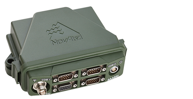
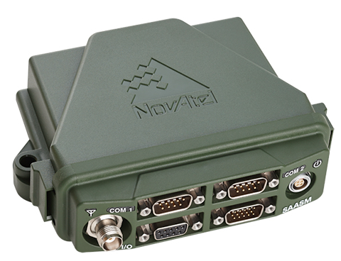
    NovAtel Inc. has released the OEM617D receiver, a compact, dual-antenna, dual-frequency, single-card receiver with NovAtel’s ALIGN heading functionality and RT-2 Real Time Kinematic (RTK) GNSS positioning technology, in dynamic and static environments.

    NovAtel made the announcement at AUVSI’s Unmanned Systems 2014, being held this week in Orlando, Florida.

    The OEM617D offers complete dual-frequency operation with GPS, GLONASS, and BeiDou signals maximizing GNSS availability globally. It also tracks Galileo, SBAS, and QZSS. It is designed for rotary-wing aircraft, marine, autonomous ground vehicle, and other applications requiring precise position and heading accuracy.

    NovAtel’s advanced firmware and correction capabilities enhance the positioning performance of the OEM617D receiver, the company said. Firmware is field upgradable and scalable, depending on application needs. In addition to RTK centimeter-level real-time positioning, and ALIGN precise heading and relative positioning, the OEM617D offers GLIDE for decimeter-level pass-to-pass accuracy and RAIM for increased GNSS pseudorange integrity.

    “We continually listen to our customers to ensure we develop new innovations that address their performance requirements and ensure their competitive success in the marketplace,” said Cameron Henderson, NovAtel’s product manager, Core Cards. “With the release of OEM617D, we’ve delivered robust and accurate positioning on our smallest form factor, making it a great solution for the unmanned market.”

  • FlexPak-S GNSS Enclosure Delivers SAASM Positioning for Defense

    FlexPak-S GNSS Enclosure Delivers SAASM Positioning for Defense

    NovAtel's FlexPak-S GNSS SAASM enclosure.
    NovAtel’s FlexPak-S GNSS SAASM enclosure.

    NovAtel has launched the FlexPak-S GNSS SAASM enclosure. The FlexPak-S contains a NovAtel dual-frequency OEM625S receiver card integrated with L-3’s XFACTOR Selective Availability Anti Spoofing Module (SAASM) onboard. The FlexPak-S is security-approved by the GPS Directorate for operational use.

    NovAtel made the announcement at AUVSI’s Unmanned Systems 2014, being held this week in Orlando, Florida.

    When keyed by authorized defense integrators, the FlexPak-S provides centimeter-level Real Time Kinematic (RTK) Precise Positioning Service (PPS) solution by taking the raw measurements from the XFACTOR SAASM and applying them to NovAtel’s Advanced RTK algorithms. The FlexPak-S can be handled as unclassified when keyed.

    In the Standard Positioning Service (SPS) fallback mode, the FlexPak-S continues to provide centimeter-level accuracy by utilizing NovAtel’s dual-frequency civil GNSS positioning engine. FlexPak-S’ fallback mode is configurable for GPS or GPS+GLONASS. Adding GLONASS tracking increases position performance in obstructed sky conditions, which is a benefit for unmanned ground vehicles.

    FlexPak-S was developed for size-constrained environments, so it’s compact and lightweight, NovAtel said. Despite its size, the rugged GNSS enclosure has been engineered to ensure reliability, even in harsh environments. The IP67 housing is water-resistant and operates in a wide temperature range. FlexPak-S also allows for easy integration with standardized hardware connections and NovAtel’s comprehensive set of software commands. The SAASM position is provided via a dedicated communication port, as well as through NovAtel’s software command protocol, allowing for maximum flexibility. FlexPak-S uses the same form factor as the FlexPak6 design.

    “FlexPak-S is a great option for customers looking for a reliable solution in environments where size is critical, like UAV and robotics applications,” said Shane McEwen, product manager for NovAtel Enclosures. “With standard software and hardware connections, integration is simplified so there is a quicker time to market.”

    The FlexPak-S is available to order immediately.


  • Trimble Launches New Version of 4D Control Software

    Trimble-deformation-O

    Trimble has introduced the latest version of its deformation monitoring software, Trimble 4D Control version 4.3. The latest version features new optional monitoring applications — the High Rise App, the SeismoGeodetic App and the Trimble 4D Control Site Setup App for Trimble Access — to better analyze complex data communicated from a broad range of GNSS, optical, geotechnical, seismic, atmospheric and metrological sensors.

    Trimble says it is continuing to expand the ways in which quantifying movement change can be automated using a range of geodetic, seismic and engineering sensors. The opportunities in automation play a significant part in effective project safety management and construction strategies, the company said. Equally important is the analysis of complex data communicated via simple visual terms in order to understand the impacts of change between disciplines.

    Version 4.3 includes a dedicated page to support the functionality of the High Rise App and Composite Views for combining charts, plots and other displays. High-frequency charts, comparative bar charts, tabular and windrose analysis as well as a new visualization tool designated for in-place inclinometers and tilt meter arrays are ways to examine complex data and present findings in a meaningful way, Trimble said.

    In addition to the new High Rise App, SeismoGeodetic App and Trimble 4D Control Site Setup App, the software release and apps also provide new functionality for data processing, visualization and analysis. The interactive Web Interface, Trimble 4D Control Web, provides improved multi-select control and more granularity for customizing alarms.

    High Rise App: The High Rise App is intended to monitor high-rise structures during construction using GNSS and inclination sensors. Integrated processing of GNSS, total station and inclination data delivers precise and reliable coordinates on demand for stake-out jobs on structures subject to tilt such as towers and high rise buildings.

    SeismoGeodetic App: The SeismoGeodetic App integrates the advantages of high-precision GNSS data and high frequency strong motion data. The data from co-located GNSS receivers and Trimble REF TEK strong motion accelerometers can now be processed in an integrated approach resulting in high-precision 3D positions up to a sample rate of 500 Hz.

    Trimble 4D Control Site Setup App for Trimble Access: The Trimble 4D Control Site Setup App for Trimble Access field software allows the user to create, enhance or modify a total station site setup for Trimble 4D Control using a Trimble field controller. Once the site setup has been transferred to Trimble 4D Control, round measurements can be performed immediately without the need to run the Site Setup functionality on the server.

    Trimble 4D Control version 4.3, High Rise App, SeismoGeodetic App and the Trimble 4D Control Site Setup App for Trimble Access software are available now from Trimble’s worldwide Infrastructure distribution network.

  • Leica Geosystems Offers CC55 Controller

    The Leica iCON CC55 controller is part of the Leica iCON portfolio.
    The Leica iCON CC55 controller is part of the Leica iCON portfolio.

    Leica_ICON_CC55_with_screen-WLeica Geosystems now offers the Leica iCON CC55 controller, a versatile and rugged PDA with a 3.5-inch color display, as part of its iCON construction portfolio. The handheld controls Leica iCON sensors, runs the iCONstruct field software, and has a QuadraClear sunlight readable display and a fast 1-GHz processor.

    The smaller Leica iCON CC55 handheld controller, as well as the seven-inch Tablet PC Leica iCON CC65/66 field controller, are both fully integrated into Leica Geosystems’ iCON portfolio of hardware and software solutions. It runs the Leica iCON build or site software to display and connect measured points for as-built data capturing or to lay out points and construction lines directly from the digital construction plan. The controller provides flexible options for data communication and an extensive data storage.

    Leica_iCON_CC55_application-WThe Leica iCON CC55 can be used to control the Leica iCON robot total stations, enabling one-person operation, saving time and increasing productivity for construction layout tasks and as-built checks, the company said. The optional Long-Range Bluetooth allows communication with the iCON robot 50 at distances of more than 350 m/1150 feet. Alternatively, the iCON CC55 can be used as a data logger with the Leica Builder manual total station. Together with the versatile Leica iCON gps 60 SmartAntenna, the iCON CC55 creates a compact and light-weight GPS rover system.

    The iCON CC55 runs the state-of-the-art Windows Embedded Handheld 6.5 operating system and comes with 256MB NAND Flash memory and 8 GB of extended storage, enabling extensive data process and storage capacity. An internal WLAN module and Long-Range Bluetooth offer users impressive distance communication, the company said, and the longer life 5.6Ah battery lets users easily complete a full day’s work. The iCON CC55 also comes equipped with a 5-MP camera so users can document their construction projects.


  • Ebook Looks at GIS in Health Care

    ebook-healthcare-GIS

    American Sentinel University’s new e-book,The State of the Modern Health Care Industry in the 21st Century: Technology and Business Intelligence Leads the Way, profiles the technology shifts in health care and offers an inside look into how geographic information systems (GIS) can be applied in health care organizations and the industry’s growing need for professionals with GIS knowledge.

    GIS has quickly become an important tool for contemporary health care organizations to run more efficiently and effectively. While some organizations are using GIS to its full potential, others seek additional opportunities to apply geospatial tools and concepts and created an increased demand for GIS professionals.

    Watch the e-book trailer here.

    “Legislation calling for the transition to electronic health records (EHRs) and pay-for-performance initiatives has brought GIS tools front and center,” said Stephen A. McElroy, Ph.D., GIS program chair at American Sentinel University.  “GIS tools provide dynamic data visualization techniques to health care organizations to help them better understand the geographic relationships that affect health outcomes, public health risks, and disease transition to improve their overall strategic decision-making processes.”

    The e-book provides information to those who want to learn how GIS helps improve patient outcomes; increase efficiencies; gain important career insight about the tech shifts in health care; and understand how these changes have resulted in unlimited career opportunities for GIS professionals.

    Topics include:

    • What GIS does for the health industry
    • Health care’s increasing need for GIS insight
    • Job outlook for GIS professionals in health and human services
    • American Sentinel’s GIS programs
    • GIS program comparison worksheet

    “The health care industry is strong and growing. Projected to create 28 percent of all new jobs, this industry is expected to increase its reliance on geospatial technologies. Now is a great time to consider earning a GIS degree as the future looks promising in health care for GIS professionals,” said Dr. McElroy.

  • Smart Mapping SuperSurv Available on App Store and Google Play

    SuperSurv-2Supergeo Technologies, a provider of GIS software and solutions, has launched SuperSurv, a mobile GIS app, on the App Store and Google Play.

    SuperSurv contains comprehensive GIS data-collection functions. Designed for both iOS and Android powered devices, it integrates with GIS and GPS technologies to provide functions in field survey, such as Map Display, Query, Measure, etc. With SuperSurv, the collected data can be saved as feature layer (point, line, polygon) in SHP or GEO format in offline mode. SuperSurv supports OpenStreetMap as the base map.

    SuperSurv has been successfully applied in various industries worldwide, including environment protection, pollution prevention, and facility management. The free trial version is now available on Apple App Store and Google Play, allowing users to experience complete functions for seven days before purchase.

    SuperSurv-1For users in North America, Supergeo has released the SuperSurv M3 version to provide easy-to-use and useful data collection and map display functions. SuperSurv M3 supports feature-layer display and offline editing functions. Furthermore, cached maps can be adopted as the base map to facilitate data capture tasks.

    SuperSurv (iOS)

    SuperSur M3 (iOS)

    SuperSurv (Android)

    SuperSurv M3 (Android)


    Screenshot: SuperSurv, Supergeo Technologies

  • Tallysman Offers Low Current Multi-Constellation Compact GPS Antennas

    Tallysman Offers Low Current Multi-Constellation Compact GPS Antennas

    Tallysman TW4327 and TW4329 antennas.
    Tallysman TW4327 and TW4329 antennas.

    Tallysman Wireless, Inc., is offering a family of very low power, compact, high-performance GNSS antennas for precision, commercial, and military applications.

    Based in Ottawa, Canada, Tallysman Wireless,  is a designer and manufacturer of high-performance GNSS, Iridium, and Globalstar antennas and associated components.

    The TW4327 and TW4329 are low-power GPS L1 + GLONASS G1 antennas that feature current consumption of 1.75 mA typically and parametrically invariant performance over a supply range from 2.5V to 12V.

    The TW4327 offers a 21-dB gain minimum, and the TW4329 includes a narrow pre-filter to prevent front end saturation by near out-of-band interfering signals.

    Both antennas are more tolerant to detuning effects caused by the operational environment, thanks to a 40% thicker patch element that provides wider bandwidth than conventional antennas. These antennas are also very compact (38mm x 38mm x 14.4mm), making them ideal for use in a wide range of locations.

    The TW4027 and TW4029 are equivalent antennas for reception of GPS L1 signals.

    “These products are ideal for any battery operated applications where low power is a pre-requisite,” said Gyles
    Panther CEO of Tallysman Wireless, “and the wider patch element bandwidth will minimize detuning in non-ideal
    environments, such as in covert applications.”

    Tallysman Wireless has recently added an authorized distributor of its products for Russia (Aurora Mobile Technologies), and another distributor for Asia (Advanced Information Technology, Inc.), for the countries of Vietnam, Hong Kong, Singapore, China, Indonesia, and India.

  • Spectra Precision’s MobileMapper 20 Extends GIS Capabilities in the Field

    Spectra-Precision-MobileMapper-20-App-O

    Spectra Precision has introduced the MobileMapper 20 GIS handheld. In the same form factor as the current MobileMapper 10 handheld, MobileMapper 20 offers enhanced capabilities: a new bright VGA color touch screen display, a 5-MP camera for higher resolution images, doubled memory capacity and 3.5G cellular performance.

    The Spectra Precision MobileMapper 20 provides real-time GPS accuracy of better than 2 meters and post-processed accuracy of a half-meter using MobileMapper Office software. Mapping professionals can also take advantage of Spectra Precision’s optional MobileMapper Field software for data collection, maintenance and inspection.

    MobileMapper 20 GIS handheld.
    MobileMapper 20 GIS handheld.

    MobileMapper 20 incorporates a variety of communication technologies, including Bluetooth, Wi-Fi and a 3.5 G cellular modem, to keep mobile workers connected and more efficient while in the field. With a compact lightweight design, large display and long battery life (typically more than 20 hours), the easy-to-use handheld is ideal for intensive data collection. The MobileMapper 20 runs Windows Embedded Handheld 6.5 and offers the flexibility to support a broad range of third-party software applications.

    “Building on the popular MobileMapper 10 handheld and responding to our customers’ evolving needs, we have significantly increased the power and functionality of our entry-level MobileMapper product portfolio,” said Olivier Casabianca, business area director of Trimble’s GeoInstruments. “With the introduction of MobileMapper 20, Spectra Precision is further extending the GIS capabilities of our customers in the field, while simultaneously providing them with the peace-of-mind of a standard two-year warranty.”

  • Launch a River Trip from Your Computer Using Streamer

    Streamer map of the conterminous United States showing water basins, weather radar, and real-time streamflow stations.
    Streamer map of the conterminous United States showing water basins, weather radar, and real-time streamflow stations.

    Field & Stream called it a “…very cool tool and quite a bit of fun.”  MinnPost described it as a “…high-tech illustration of Norman Maclean’s timeless view that, ‘Eventually, all things merge into one, and a river runs through it.” And Popular Science noted that, “There’s something especially satisfying about clicking a stream that…shoots its way across multiple states to empty into the ocean.”

    These publications are all describing Streamer, the popular on-line mapping program from the U.S. Geological Survey. Streamer is a powerful, yet easy way to explore our major waterways. With a simple map click, anyone can trace rivers and streams from a starting point all the way downstream to where a stream drains. Even more impressive, they can click on a stream and trace all others that drain to that point. Streamer also produces a report that includes a map and information about the people and places encountered along the streams traced.

    Streamer map of an upstream trace from a point on Belle Fourche River in South Dakota extending into Wyoming and Montana. Weather radar and real-time streamflow stations are shown on the map.
    Streamer map of an upstream trace from a point on Belle Fourche River in South Dakota extending into Wyoming and Montana. Weather radar and real-time streamflow stations are shown on the map.

    As good as Streamer was when it launched last summer, it just got better. Four major enhancements and dozens of small improvements have been made. These include:

    • A new map layer displays the locations of real-time streamflow stations across the country. Streamer updates this information hourly and symbolizes these stations to illustrate current streamflow conditions compared with each station’s observed mean streamflow on the same day of the year.
    • You can tell at a glance whether conditions are above, below, or at normal levels at each station.
    • Links are provided from Streamer directly to selected stations for additional information and data.
    • Another new map layer has been added that shows weather radar across all 50 States.
    • Useful improvements to Streamer’s detailed reports have been added. One of these lists the names of waterbodies (lakes, reservoirs, etc.) along the path of your trace.
    • Congressional Districts encountered along your trace have been added.
    • A mouse click takes you from the Streamer report to additional information from the Census Bureau about socioeconomic conditions in each District.
    • Searching for locations on Streamer’s map by place name, zip code, geographic coordinates and more is greatly enhanced.

    In its first eight months in service, Streamer users traced more than 2.9 billion river miles.

    The USGS announced in February that it is ending production of the National Atlas on September 30, and that some of its products and services would transition to The National Map. With this release, Streamer becomes the first of these National Atlas products and services that The National Map will offer.  For cartographers and geospatial information professionals, Streamer’s surface water data is available for download at no cost.

    Detail from a Streamer map of an upstream trace from a point on the Arkansas River near Geuda Springs, Kansas, extending into Colorado and New Mexico. Real-time streamflow stations are shown.
    Detail from a Streamer map of an upstream trace from a point on the Arkansas River near Geuda Springs, Kansas, extending into Colorado and New Mexico. Real-time streamflow stations are shown.
  • Esri Offers Interactive Map of Landslide Risk

    Aerial photograph of the Oso mudslide, taken by the Washington State Patrol.
    Aerial photograph of the Oso mudslide, taken by the Washington State Patrol.

    The March 22 mudslide in Oso, Washington, has drawn national attention to the danger of landslides. So far, the Snohomish County Medical Examiner’s office confirmed that 39 people had died and seven people remain missing.

    Esri provides an interactive map for users to see where the risk of landslides is low, moderate, or high in the United States.

    The map shows landslide suspectibility and incidence data from the USGS, which says this 1982 map was not intended to show landslide areas. Areas with low landslide incidence have been omitted.

    Users can click any feature on the map for detailed information about the people living in that area.
     Esri-Landslide-map