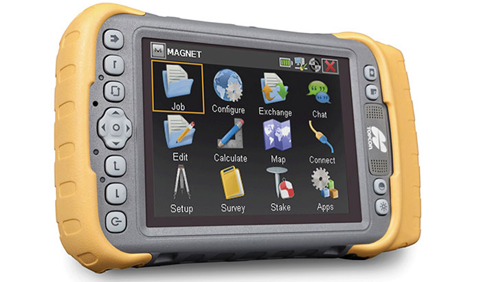
The Topcon Tesla RTK handheld controller can serve as a network RTK rover. It is designed to maximize 3D measurement tasks and use of Magnet Enterprise. Magnet is a browser-based solution to manage field and office data in the cloud, as well as track assets and communicate on projects.
The Tesla RTK features an integrated RTK GNSS receiver, 5.7-inch touchscreen, Windows 6.5.3 OS, 806-MHz processor, built-in 3.2MP camera, 3.5G cellular modem, and Bluetooth/Wi-Fi ability.
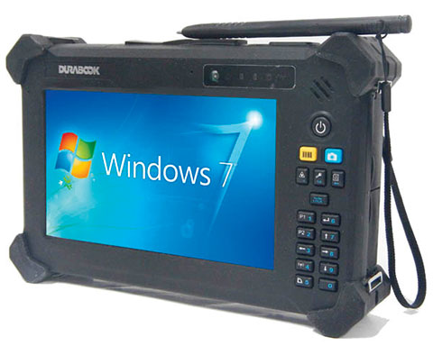
The DuraBook T7Q by GammaTech is a fully rugged Windows 7 Professional tablet PC designed to meet the demands of mobile professionals in the transportation, field services, utilities, and oil and gas industries. Designed with a magnesium-alloy case, the T7Q DuraBook Rugged Tablet is compliant with MIL-STD 810G and IP65, able to withstand vigorous bumps, knocks and sudden shock under rough handling or on-the-move, resisting dust and water.
It has a seven-inch thin-film-transistor (TFT) LCD display with resistive touchscreen panel and LED backlighting, an m-SATA SSD drive and Intel Atom Processor, and an integrated 5.0-megapixel camera at the back of the unit. Options include a barcode scanner, RFID reader, GPS receiver, and I/O ports such as USB, RS-232, and RJ-45.
ALK Technologies today released the latest version of its PC*MILER truck routing, mileage and mapping software. PC*MILER 27 features and enhancements include a completely redesigned graphical user interface for maximum efficiency and hours-of-service compliance tools for more precise arrival and delivery time estimates.
“PC*MILER 27 is a milestone for ALK. We’re thrilled to unveil this robust yet easy to use interface with an all new look and feel,” said Mike Bodden, Senior Vice President of Technology, ALK Technologies. “The new UI provides an improved user experience with easier product navigation, resulting in increased productivity.”
The new PC*MILER 27 graphical user interface reflects recent trends in software design that result in more intuitive navigation of the product’s vast feature set. The user interface features a ribbon-style design with newly crafted descriptive icons, a more accessible layout for smoother transition between tasks, and windows that can be floated outside the PC*MILER application to better accommodate workspace needs.
PC*MILER 27 features new hours-of-service compliance tools to help ensure that routes and ETAs will accurately reflect drivers’ available hours. The HOS compliance tools increase the precision of arrival and delivery time estimates and help dispatchers and drivers comply with HOS government regulations. Based on remaining hours, PC*MILER calculates when a driver needs to break, and indicates the designated breaks in the detailed driving directions report, automatically updating on-duty hours. Through the PC*MILER|Connect interface tool, fleets are able to import or export the drivers’ remaining hours associated with specific routes. With the pending new regulations, this is crucial to managing driver compliance and CSA safety scores.
RouteSync is a powerful capability that ensures operational consistency between dispatched routes and actual routes, delivering the guidance to drive the miles that are being billed. With RouteSync, routes and preferences are sent from PC*MILER in the back office directly to the latest version of ALK’s CoPilot Truck navigation software in the cab. In addition to maintaining route compliance, RouteSync reduces non-revenue mileage, improves load profitability and increases driver satisfaction.
Enhanced routing, map data and address matching are a major part of each annual PC*MILER release, ALK Technologies said. As part of ALK’s ongoing effort to track nationwide toll costs in the U.S. and Canada, PC*MILER|Tolls 27 includes four new toll discount programs.
The comprehensive suite of PC*MILER 27 integration tools has also been updated and enhanced. PC*MILER interfaces with all leading transportation, logistics and fleet management systems. These products include PC*MILER|Connect, PC*MILER|TCP/IP, PC*MILER|Mapping, PC*MILER|Spreadsheets, PC*MILER|BatchPro and Multi-Version Switch.
PC*MILER runs on Microsoft Windows, UNIX, and Linux platforms, as well as IBM AS/400 (iSeries) and mainframe computers. PC*MILER is also available as a web-based application.
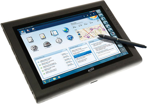
The Motion J3600 by Motion Computing is a rugged and powerful tablet PC for field professionals who need a tough device for working in harsh mobile conditions such as construction, field services, and healthcare. With third-generation Intel Core processors, the Motion J3600 offers high processing power while reducing power draw to deliver uninterrupted performance throughout the workday.
Running Microsoft Windows, the J3600 can be operated with touch navigation or a stylus. It has integrated Wi-Fi 802.11 a/b/g/n, Bluetooth, and enhanced Gobi connectivity with integrated GPS. Geotagging and date stamping with the integrated digital camera can document work in seconds.
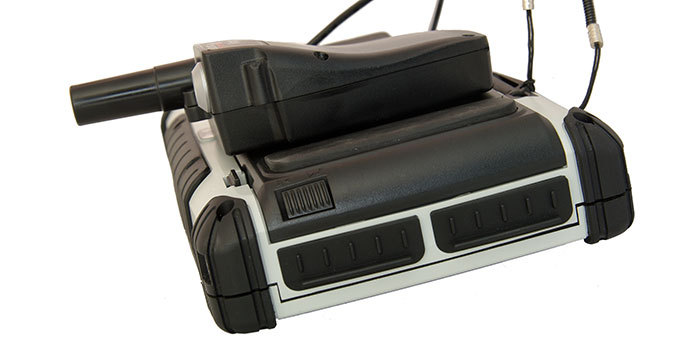
Septentrio NV, the Belgian manufacturer of high-end GNSS receivers, and Esri BeLux, the regional distributor of Esri software, have joined forces to offer a user-friendly mobile solution that is accurate up to 1 centimeter. The combination of Esri software and the AsteRx-m GeoPod operates seamlessly using standard, open interfaces on any professional tablet. Used today by a major utility company, the new bundled solution allows anyone in the organization to accurately locate field assets and record geo-referenced data on the spot, Septentrio said.
The AsteRx-m GeoPod upgrades professional tablet PCs with a high accuracy GNSS receiver, giving the user access to sub-meter, or even centimeter, accurate positions without needing specialized equipment. Using a standard USB connection, the AsteRx-m GeoPod can be connected to any professional tablet, giving the user free choice to select a device.
The receiver uses satellites from the GPS and GLONASS constellations to increase the availability of a high-quality position solution, even in areas with bad satellite visibility. In addition, the receiver offers innovative tracking and positioning algorithms designed for demanding professional environments.
The included RxAssitant software takes care of configuring the receiver and connecting to NTRIP-capable RTK or DGNSS networks, allowing a seamless integration with existing software applications like esri ArcGIS for mobile.
Applications for the AsteRx-m GeoPod include construction, field service, utility mapping, highway maintenance, government mapping and emergency services.
Effigis today announced the worldwide availability of a new version of its OnPOZ EZSurv GNSS post-processing software (V2.92). Improvements include automatic access to data from more than 8,000 base stations around the world and availability of more than 750 mapping systems, as well as enhanced compatibility with 22 native GNSS formats.
EZSurv, Effigis’ GNSS post-processing software, provides a reliable, efficient RTK offline solution to improve survey or GIS data accuracy, the company said. EZSurv is fully compatible with most industry-standard field survey and GIS data collection software.
The latest version of EZSurv offers easy, automatic access to base station providers worldwide: data from more than 8,000 stations around the world can be automatically accessed directly through the EZSurv interface, without any extra user intervention, the company said.
Effigis constantly works on bringing data from more base stations to EZSurv users to improve worldwide connectivity to regional reference frames. “We regularly implement compatibility with additional base station providers as we get the necessary technical information,” said Denis Parrot, president of Effigis. Once compatibility is established, all necessary information to access new base stations is automatically updated through the Internet, without any software release or update.
This latest release also integrates compatibility with new GNSS binary formats, which brings EZSurv compatibility to 22 native formats.
Finally, EZSurv now offers more than 750 predefined “Map Projections/Datums” to help users quickly translate GNSS positions into regional mapping systems. This predefined map projection set is continuously updated on users’ desktops by a simple Internet download.
“EZSurv V2.92 brings GNSS post-processing to an unprecedented level of ease of use,” added Denis Parrot. “EZSurv is a real gateway to many GNSS networks worldwide and provides post-processed results in the proper reference frames. Our commitment to streamline GNSS post-processing makes EZSurv the ideal tool to complement RTK systems.”
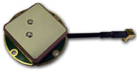
Tallysman Wireless announces the TW4421 and TW1421 antennas, which offer a step forward in performance for small GNSS antennas, the company said.
The TW4421 is a low-cost dual-feed magnetic mount antenna covering the GPS L1, GLONASS L1, Galileo and SBAS (WAAS, EGNOS & MSAS) frequency band (1574 to 1606 MHz). The TW4421 features a 25-millimeter dual-feed wideband patch element that provides excellent multipath rejection with a more linear carrier phase response, by virtue of a low axial ratio across the full frequency bandwidth, Tallysman said. It is especially suitable for high accuracy applications, and also offers high out-of-band signal rejection.
The TW4421 is housed in a compact IP67 magnetic mount enclosure and is available with a wide range of connector options.
The TW1421 embedded antenna is lightweight (30 gm) and features a very small footprint (35 mm diameter x 7.25 mm). The TW1421 is suited for use in applications where performance and small size are of paramount importance, such as extreme-sport-wearable tracking devices and UAVs.
“Most small low-cost GPS/GLONASS/Galileo antennas are narrow-band devices with an elliptically polarized response at the GPS and GLONASS frequencies,” said Gyles Panther CEO of Tallysman Wireless. “The TW4421/1421 antennas feature a 40-percent wider bandwidth patch, with a dual-feed structure, which provides unparalleled multipath rejection previously only available in much larger, more expensive antennas.”
NavCom Technology, Inc., a wholly owned subsidiary of Deere & Company, announced the release of new software for its Sapphire-based receivers, including the SF-3050, SF-3040, and LAND-PAK. The multi-frequency GNSS (GPS+GLONASS) receivers are now capable of supporting NavCom’s new StarFire Rapid Recovery feature, which allows users to quickly regain StarFire accuracy after short GNSS signal blockages caused by shading, bridges or other similar constraints. Other new features include support for proprietary GLONASS RTK correction messages from third party base stations and a new web server interface for the SF-3050.
“The functionality and capabilities gained from these new features allow our customers improved productivity in the field,” said Steve Ault, NavCom’s Product Manager. “Previously, users would have to wait out the traditional 45-minute pull-in delay when they lost the GNSS signal, but now, StarFire Rapid Recovery helps users ride through short GNSS signal outages of up to three minutes and regains 5cm StarFire accuracy within two minutes after entering StarFire mode. Our customers are now up and running within five minutes with StarFire Rapid Recovery, thereby increasing the maximum possible uptime.”
NavCom’s StarFire Network, a Global Satellite Based Augmentation System, provides five centimeter horizontal accuracy worldwide and the freedom and flexibility that a DGPS solution offers, NavCom said. Starfire offers 99.999% uptime, a seven-satellite constellation, and StarFire over IP (SFoIP) delivery for redundancy to ensure system availability and position accuracy.
StarFire Rapid Recovery and third-party GLONASS RTK are options available via a software update for all current StarFire receivers offered by NavCom’s global dealer network.
Trimble has introduced its next-generation Unmanned Aircraft System (UAS) — the Trimble UX5 aerial imaging rover with the Trimble Access aerial imaging application. The new solution builds upon the strengths of its predecessor, the Trimble Gatewing X100, to offer enhanced image quality and intuitive workflows. Combined with the Trimble Business Center photogrammetry office software module, the Trimble UX5 is the a complete UAS photogrammetric mapping solution specifically designed for surveyors and geospatial professionals.
Trimble’s UAS for photogrammetric aerial mapping allows surveyors and geospatial professionals to collect data with an unmanned aircraft for large projects. A wide variety of traditional surveying applications such as topographic surveying, site and route planning, progress monitoring, volume calculations, disaster analysis and as-builts in industries such as surveying, oil and gas, mining, environmental services, and agriculture can now benefit from aerial imaging by allowing professionals to safely collect large amounts of accurate data in a short time.
“With the recent introduction of the Trimble Business Center photogrammetry module and now the Trimble UX5 and Trimble Access aerial imaging application, Trimble continues to pioneer the development of UAS photogrammetry data collection and integration for geospatial professionals,” said Erik Arvesen, vice president of Trimble’s Survey Division. “The complete solution represents a significant leap in efficiency, transforming traditional workflows with faster data collection, easier processing and enhanced deliverables.”
The new Trimble Access aerial imaging application is field software for planning UAS missions, performing flight checks and monitoring flights — all with intuitive workflows. The imaging application is used to define the project area, avoidance zones, and flight parameters as well as take-off and landing locations. In the field, it is used to perform pre- and post-flight checks and download the flight data and images after landing. The new wizard-like digital checklists give the operator a complete “to-do list” so critical steps are not bypassed or missed in the field that can enhance reliable and safe flights. The software also includes fixed post-flight procedures to ensure that operators do not leave the field with a dataset that is incomplete or inconsistent.
The Trimble UX5 can provide a safer method to collect data compared to traditional surveying methods, Trimble said. Flights are fully automated, from launch to landing, and require no piloting skills. The operator facilitates the aircraft’s operation and built-in safety procedures can ensure safe and successful launches. Data collection can be performed remotely without exposing individuals to hazardous terrain, environmental contaminants or heavy equipment and machinery.
The Trimble UX5 unmanned system in use at a construction site. Photo: Trimble
The Trimble UX5 aerial imaging rover has been designed to follow the latest developments in the “prosumer” camera market, providing optimal image quality along with maximum photogrammetric accuracy.
Incorporating a mirrorless 16-megapixel camera with a fixed focal-length external lens, the Trimble UX5 provides high-resolution imagery and accurate deliverables. The large field of view from the camera allows the UX5 to cover 50-75 percent more area to enhance efficiency and reduce operational costs. In addition to the increase in flight efficiency, the Trimble UX5 is capable of producing 3D surface deliverables with a ground sampling distance of approximately 2.4 centimeters (approximately 1.0 inch).
Designed to operate in real-world conditions, the Trimble UX5 is capable of flights between 75 and 750 meters (approximately 246 and 2,460 feet) above ground level and can be flown in light rain and windy conditions, up to 65 kph (approximately 40 mph).
The Trimble UX5 airframe is comprised of a carbon frame inside expanded polypropylene. Impact-resistant plastics and composite fibers are used for the aircraft components, including winglets and belly plate. This design and choice of materials results in a rigid aircraft with strong torsional stability and the ability to withstand rough landings.
Performance enhancements also include the ability to execute steep landing approaches and thrust reversal for accurate and repeatable landings. The landing procedure starts 300 meters (approximately 984 feet) from the landing location allowing the UX5 to be used for jobs that have site restrictions such as buildings, towers or trees.
Orthophotos, contour maps, point clouds, digital surface models (DSMs) and feature maps can easily be created from aerial images using the Trimble Business Center photogrammetry module. Single-click processing for stitching images streamlines the office process for generating powerful deliverables, Trimble said.
The Trimble Business Center allows surveyors and other geospatial professionals to combine aerial photography with data collected from GNSS receivers, total stations, 3D laser scanners and more. By combining imagery from the Trimble UX5 and any Trimble VISION instruments, users can visualize their project from both aerial and terrestrial perspectives, measure points within the images and create 3D models of the infrastructure and terrain.
Trusted Positioning has released the Trusted Portable Navigator (T-PN) indoor location software. Available for any operating system, this mobile embedded software allows mobile users to navigate shopping centers, airports, and subway stations. No additional hardware or infrastructure required.
The T-PN combines the use of existing smartphone motion sensors with wireless updates (such as Wi-Fi and GNSS) for a complete solution with no extra hardware or infrastructure needed.
T-PN needs no additional infrastructure: This enables a consumer to navigate through an environment with no existing navigation technology. T-PN integrates with existing sensors such as Wi-Fi and GPS when available and utilizes significantly less power than either GPS or Wi-Fi positioning. The company reports that accurate positioning can be maintained while the phone is swinging in a hand, a call is answered, the phone is in a pocket or purse, or the consumer is texting.
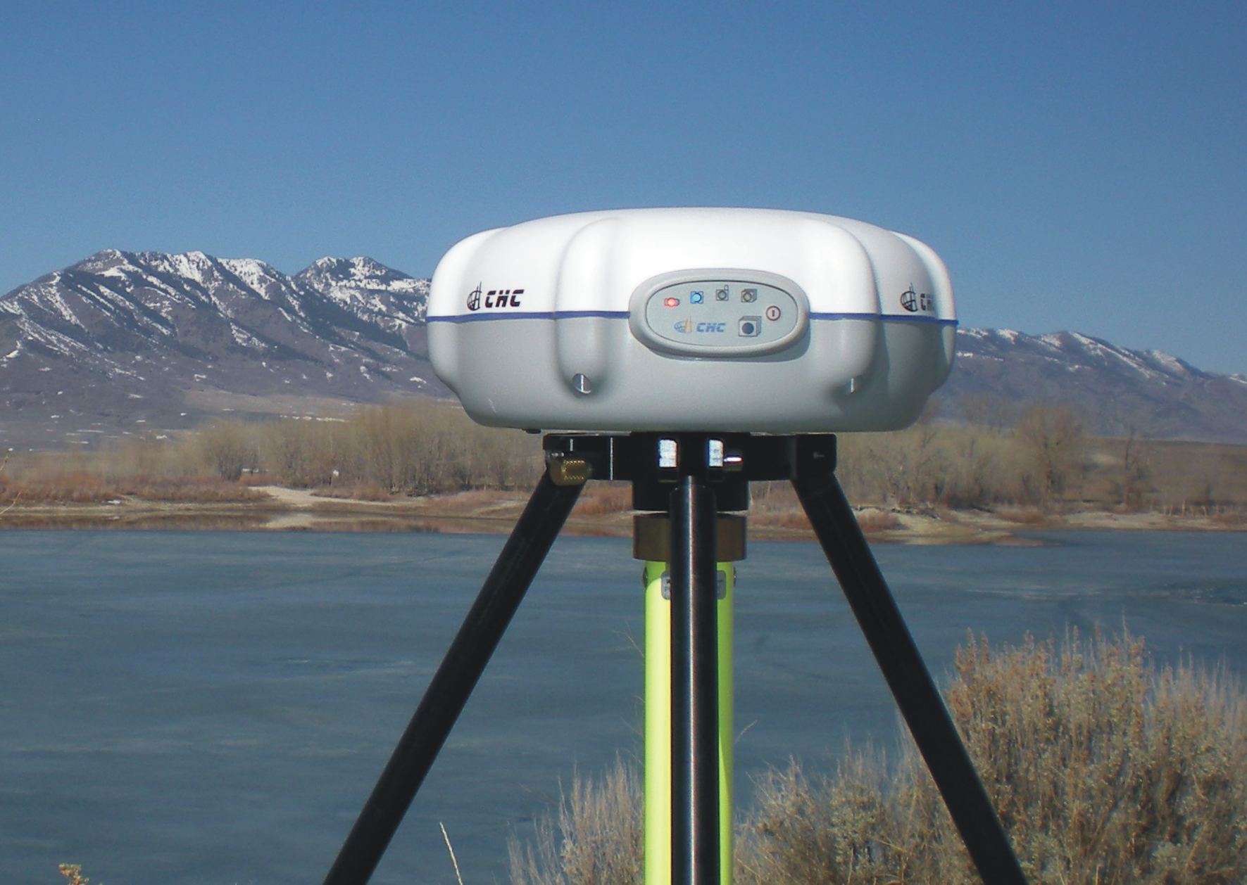
iGage Corporation announces the introduction of a simple, low-cost, L1/L2/L2C GPS receiver specifically designed to use the National Geodetic Survey’s OPUS online post-processing service. The X90-OPUS has a single button interface and customized firmware/software to automate data submissions to OPUS for centimeter-level post-processing anywhere in the United States.
At only US$2,450, iGage reports that the X90-OPUS is the least expensive L1/L2 GPS surveying receiver in the world. Its 4GB internal memory stores more than four years of 15-second interval data. A simple plug-and-play USB connection behaves exactly like a USB memory stick on the user’s computer for easy data download.
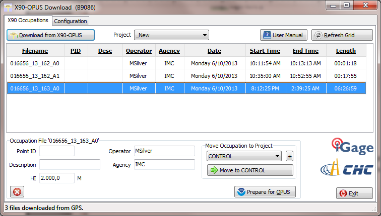
The X90-OPUS Download software has single button download. Another button press decimates occupation data, ZIPS the observation file, and automatically fills in the entire OPUS online submission form.
Photo: iGage
According to the announcement, the X90-OPUS makes field surveying easy, no data collector is required just press the power button to begin and end an observation.
“We have taken our years of static GPS surveying experience and boiled it down to a simple one-button operation,” said Mark Silver, President of iGage. “You turn it on and it works. There are no data collectors and no complicated displays. It is drop-dead simple.”
The X90-OPUS receiver is waterproof, submersible, nonincendive, and it floats (IP-67). It carries a standard two-year warranty. The package includes two rechargeable batteries, a dual slot charger, external power cable, and hard shell carrying case.
At 3.1 lbs and less than 8” in diameter, the 24-channel L1/L2/L2C X90-OPUS is ideal for surveying using OPUS, OPUS-RS, OPUS Projects, and standard static surveying campaigns. With a low cost of ownership, the X90-OPUS virtually eliminates the need for “leap-frogging” GPS receivers in large static campaigns.
The X90-OPUS is available immediately. Details are available at http://www.x90gps.com.
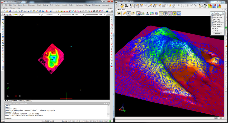
MicroSurvey, the maker of MicroSurvey CAD and the MapScenes System, announces the release of three new software versions optimized to make full use of datasets from the new Leica Nova MS50 MultiStation. MicroSurvey CAD Ultimate 2013, MicroSurvey CAD Studio 2013 and MapScenes PointCloud 2013 provide complete point cloud and Leica Nova MS50 support in an intuitive interface that allows users to quickly and easily integrate 3D point cloud data into their workflows.
Photo: MicroSurvey
MicroSurvey CAD Ultimate 2013, the desktop survey and design software solution for surveyors, contractors and engineers, provides a familiar field-to-finish CAD survey solution with the Leica Nova MS50 MultiStation. With just a few clicks, users can easily import datasets from the Leica Nova MS50 complete with all TPS measurements, pictures, points and scan data. For users who need to enhance their data visualizations with fly-through movies and animations, MicroSurvey CAD Studio 2013 includes all the functionality of MicroSurvey CAD Ultimate plus a powerful animation module capable of creating stunning movies.
MapScenes 2013, drafting, point cloud data visualization and animation tool for forensic investigators, accident scene reconstructionists and other public safety professionals, now includes the ability to take advantage of the rich 3D datasets captured by the Leica Nova MS50 MultiStation. MapScenes 2013 lets the user quickly and easily draw in the point cloud view for extremely fast, accurate linework as well as use the scan data from the Leica Nova MS50 in animations for accurate and compelling reconstructions.
MicroSurvey CAD Ultimate 2013, MicroSurvey CAD Studio 2013 and MapScenes 2013 are available as optional software packages with the Leica Nova MS50 MultiStation. For more information, visit www.microsurvey.com or www.mapscenes.com.