Tag: product showcase

  • Trimble Introduces Next-Generation Tablet PC for Surveying

    Trimble Introduces Next-Generation Tablet PC for Surveying

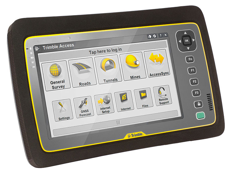
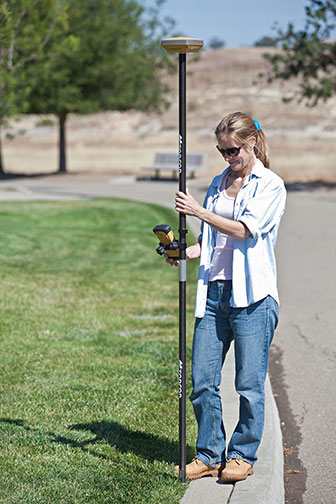
    Trimble introduced today its next-generation Trimble Tablet PC for surveying. The Trimble Tablet is a lightweight, rugged and highly mobile field computer that can operate with Trimble’s suite of receivers and total stations to provide a complete surveying solution. With Trimble Access field software onboard, the Trimble Tablet streamlines the flow of information between the field and office while also allowing surveyors to run the applications they need to perform office work directly from the field.

    The Trimble Tablet offers a 7-inch capacitive multi-touch screen in an easy-to-hold form factor that measures 6.3 inches x 9.6 inches and weighs three pounds. An extended battery set provides up to 16 hours of operation.

    With the Microsoft Windows 7 Professional operating system, a 1.6 GHz Intel Atom dual-core processor, 4 GB RAM and 128 GB of flash-based storage onboard, the Trimble Tablet allows surveyors to run a variety of the applications they need to perform office work fast and reliably. Connectivity via Bluetooth, Wi-Fi and a built-in 3.75G GSM cellular data modem enables manageable and efficient workflows so surveyors can remain connected wherever networks are available. With the Trimble Tablet, surveyors can check their work and deliver it to clients without a trip back to the office.

    Photo: Trimble
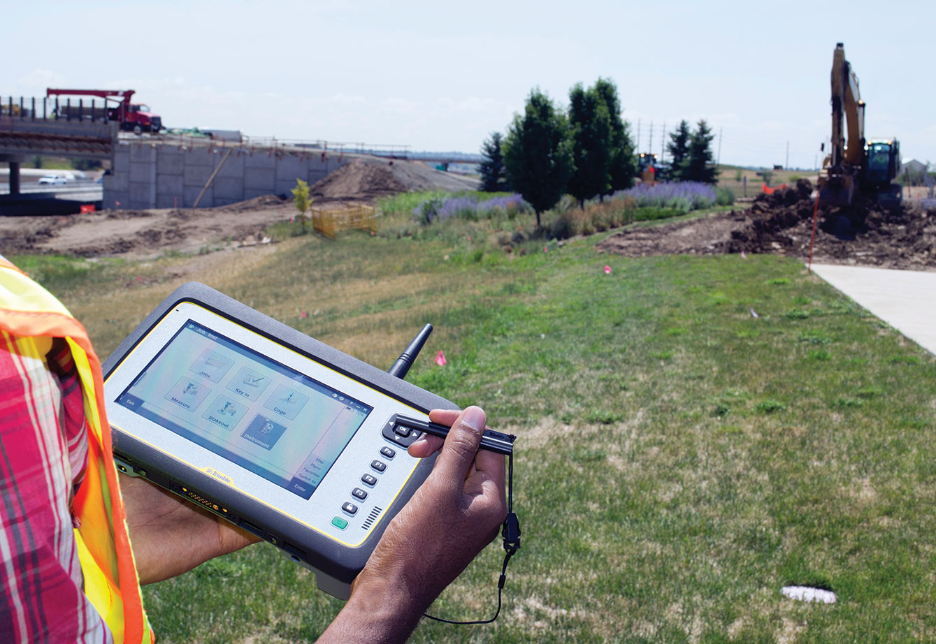
    Using the multi-touch capacitive touchscreen, surveyors can type, pan, and zoom with their fingers, a stylus or capacitive gloves. The large display features new technology created specifically to enhance sunlight readability. Viewing data, maps and applications is also easier so that surveyors can unlock the full potential of Trimble VISION instruments and applications dependent on highly visual data and graphic interfaces. Jobsite documentation is possible using the Trimble Tablet’s built-in 5MP camera with autofocus and built-in flash capabilities, while simultaneously providing geotag functionality using integrated GPS.

    Ruggedized for extreme conditions, the Trimble Tablet holds an environmental rating of IP65 and can operate in temperatures of –30 °C to +60 °C (–22 °F to +140 °F), providing exceptional versatility, efficiency and portability. The full-color screen resides under a Gorilla Glass panel that is scratch and impact resistant.

    “The ability to stay connected and complete office work from the field is becoming increasingly important to surveyors,” said Elmar Lenz, business area director of Trimble’s GNSS and survey handheld solutions. “With new features and functionality, the next generation Trimble Tablet rugged PC is an ideal solution that provides even more capability to surveyors—more memory, computing power, connectivity, data visualization, increased documentation and more.”

    The Trimble Tablet rugged PC is available for ordering immediately through Trimble’s Survey distribution channel.

    Photo: Trimble

  • Settop Survey Offers Network RTK Repeater

    Photo: Settop SurveySettop Survey is offering the Settop Repeater, which allows network RTK rover use in areas of low- or non-GSM coverage by receiving differential corrections via radio. A new firmware update allows connection via any external radio to connect the repeater to precision agriculture systems or machine control. Repeater field application versatility is managed by intuitive software using a touchscreen.

  • Underwater Inertial Navigation Features GPS and Sensors

    Underwater Inertial Navigation Features GPS and Sensors

    Photo: Advanced Navigation

    The Sublocus underwater inertial navigation system by Advanced Navigation features high-accuracy north-seeking fiber-optic gyroscopes and accelerometers with a GPS receiver and pressure depth sensor, fused to deliver positional accuracy of 0.08 percent of distance traveled. The system also provides highly accurate roll, pitch, heading, heave, depth, and altitude.

    Sublocus is also available with an integrated RDI Workhorse Navigator DVL for combined acoustic and inertial navigation in the one product. Both models are supplied with a subsea GPS antenna and are rated to 3,000 meters depth.

  • British Cartographic Society Celebrates 50 Years

    CAJ_cover_thumbThe British Cartographic Society (BCS) celebrates its 50th anniversary this year. Since 1963, the Society has been supporting individuals and organizations dedicated to exploring and developing the world of maps. Part of its celebration includes a special issue of The Cartographic Journal, which will bring together an interesting range of reflective and forward looking articles covering one simple question: “What does cartography mean to you?”

    The Cartographic Journal’s 50 volumes have spanned 115 issues and over 1000 articles in its lifetime. The journal is edited by Kenneth Field, senior cartographer at Esri, Inc., and former principal lecturer in GIS at Kingston University, London. It is an established peer reviewed journal of record and comment containing authoritative articles and international papers on all aspects of cartography, the science and technology of presenting, communicating and analyzing spatial relationships by means of maps and other geographical representations of the Earth’s surface.

    “This very special 50th anniversary issue brings together the leading lights in cartography today,” Field said. “Representing academia, commercial mapping, publishing and the so-called neo-cartographers, each contributor has fashioned a personal, reflective piece that will encourage thought and debate as we look to the future. There are some fascinating insights as well as key questions posed that will launch the Journal towards the next 50 years of publication.”

    The society will also be hosting a 50th anniversary celebratory conference titled “Today, Tomorrow and Beyond” at the historic Hothorpe Hall, Leicestershire, September 3-6, to reflect on the society’s forward vision for the future of cartography.

    The BCS aims to promote the art and science of cartography through publications, events, awards and educational workshops. Members include mapping companies, designers, academics, researchers, map curators, individual cartographers, GIS specialists and ordinary members of the public with an interest in maps.

    The special issue is available completely free to download throughout 2013. The entire 50 years of The Cartographic Journal is available to subscribers via IngentaConnect.

  • SBG Systems Offers Dual-Antenna GNSS Inertial System

    The Ekinox-D.
    The Ekinox-D. Photo: SBG Systems

    SBG Systems has added a new inertial system to its Ekinox Series. With integrated Dual Antenna GPS + GLONASS receiver, the Ekinox-D is a ready-to-use survey-grade inertial navigation system that provides consistent true heading (0.05°), SBG Systems said.

    The Ekinox-D is a high-performance inertial navigation system that embeds a dual-antenna L1/L2 GNSS receiver to deliver more robust heading and position, while increasing satellite reception availability. Ekinox-D is an integrated system: GNSS data and inertial information are fused by an Extended Kalman Filter (EKF) to improve data integrity. This computation allows the system to achieve 0.05° roll, pitch, and true heading; 5-cm heave; and 2-cm RTK GNSS position.

    The Ekinox-D is an all-in-one Solution for demanding applications. Instead of mounting separate GNSS receiver and inertial systems on a boat, car, or plane, the Ekinox-D can be installed and connect it to a  camera, SONAR, or LiDAR system. With its 8-GB datalogger and its high output rate (200 Hz), Ekinox-D joins simplicity and performance for applications where robust heading is required such as surveying and hydrographic applications, unmanned system navigation, and auto testing.

    The IP68 Ekinox Series brings robust, maintenance free, and cost-effective MEMS to the next level thanks to a drastic selection of high-end MEMS sensors, an advanced calibration procedure, and powerful algorithm design, SBG Systems said, adding that compromise is no longer required between high accuracy and cost.

  • Tallysman Introduces Dual-Frequency Antenna Series

    Tallysman Introduces Dual-Frequency Antenna Series

    TW3802 Shown with flat radome.  Conical radome also available.
    TW3802 Shown with flat radome. Conical radome also available.

    Tallysman Wireless Inc. has added the dual-frequency TW3800 series to its high-quality precision line of antenna products.

    The TW3800 series antennas feature a circular stacked patch antenna for improved axial ratio, yet are small and light, and have the extended bandwidth required for L1/L2 GPS & G1/G2 GLONASS, the company said. The operating voltage range is from +2.5 to 16 VDC. The antennas have a temperature compensated LNAs and operate from -40 to +85o C to provide reliable performance in most any environment. The TW3800 is packaged in a through hole mount making it suitable for mobile applications.

    The TW380x is suited for many applications, including:

    • Anti-jamming GPS
    • Mission-critical GPS timing
    • Military and security
    • Network timing and synchronization
    • Precise tracking
    • High signal availability

    The TW3805 is the OEM version of the TW3802, and can be custom tuned to provide optimal performance inside virtually any housing, Tallysman said.

    “The circular patch design of the TW380X antennas permits precision custom tuning with excellent axial ratios.”  said Gyles Panther, president of Tallysman Wireless. “This flexibility, combined with the very wide operating voltage enables this antenna to work with virtually any receiver on the market.”

    The Tallysman TW3805HR antenna.
    The Tallysman TW3805HR antenna.


  • Two Products Added to NovAtel’s OEM6 Receiver Line

    Two Products Added to NovAtel’s OEM6 Receiver Line

    NovAtel has announced two new GNSS receivers: The OEM638 high precision receiver card and the ProPak6 enclosed receiver. The two products incorporate NovAtel’s most advanced GNSS technology, the company said.

    Novatel OEM638.
    Novatel OEM638. Photo: NovAtel

    The most advanced card within NovAtel’s OEM6 GNSS receiver family, the OEM638 tracks all existing and planned constellations including GPS, BeiDou, GLONASS, Galileo and QZSS. By providing flexible positioning options, from standalone meter-level to AdVanceRTK centimeter-level accuracy, the OEM638 offers the flexibility to meet a wide range of positioning requirements. A powerful API, 4-GB on-board data storage, wide input voltage and a host of interface options simplifies integration, decreasing time to market and overall system costs, NovAtel said.

    “With the addition of the OEM638 GNSS receiver card, NovAtel’s OEM6 product line offers an even wider range of positioning options on our standardized technology platform. With three compact form factors to choose from, the OEM6 product line gives us the ability to meet the unique size, weight and performance requirements of our customers,” said Jason Hamilton, director of marketing for NovAtel.

    The ProPak6 is NovAtel’s most sophisticated GNSS enclosure product, offering meter-level to centimeter-level positioning in a rugged, water resistant IP67 housing. Standardized software and hardware connections, including multiple RS-232/RS-422 serial ports, CAN Bus, USB host and device, as well as Bluetooth, Wi-Fi, and optional cellular radio, speeds time to market and maximizes user capabilities, the company said. The ProPak6 is designed for reference station, timing, and general position applications.

    NovAtel ProPak6. Photo: NovAtel
    NovAtel ProPak6. Photo: NovAtel

    “Our ProPak6 provides a powerful enclosure option for integrators looking for positioning flexibility, multiple communication options and Ethernet support for remote configuration and access of data logs,” Hamilton said. “It was designed to simplify the integration process, by accelerating time to market and ensuring maximum return on investment. ”

    The OEM638 and ProPak6 will be available to order July 26, with shipments beginning in August.

  • Geotab Launches Telematics ID Key Solution with IOX Technology

    Geotab Launches Telematics ID Key Solution with IOX Technology

    Geotab has launched a telematics Near Field Communications (NFC) Driver ID solution using an Input-Output-Expander (IOX) that allows for simultaneous connections and communications to occur with multiple devices, such as Garmin, Iridium, and HOS.

    As an addition to its comprehensive fleet management platform, the technology will now help managers keep better track of each driver’s productivity and on-road safety — no matter which vehicle they are in, Geotab said.

    With one touch of the NFC fob, vehicle operators can quickly, easily, and securely transfer their driver identification information to the cloud. Since Geotab’s GO6 device allows for multiple plug-and-play connections, the NFC Driver ID solution can be setup in minutes, the company said. Associating drivers with the vehicles they are in also allows for the software to generate driver-based score reports.

    “The newly launched NFC Driver ID is a telematics industry game-changer that provides a reliable and accurate solution for businesses which pool their vehicles,” said Colin Sutherland, Geotab VP.

    “NFC is seeing rapid application expansion across smartphones, tablets, and laptops. We fully expect to leverage this technology for future applications,” added Neil Cawse, Geotab CEO.

    Although Geotab is launching a new Driver ID solution based on NFC, Geotab’s web-based software, MyGeotab, has been reporting both driver and vehicle summary value reports for over 10 years. The NFC Driver ID solution is now available for purchase through Geotab’s extensive Authorized Reseller network.

  • SAP to Integrate GIS Offerings with Esri ArcGIS Platform

    SAP AG today announced it has joined forces with Esri to more deeply integrate Esri’s geographic information system (GIS) solutions with platforms and enterprise applications from SAP. The move is expected to improve business efficiency and decision-making for SAP customers. The announcement was made at the 2013 Esri International User Conference, being held July 8-12 in San Diego.

    End-to-end support from Esri for spatial data is planned across SAP HANA, the SAP BusinessObjects Business Intelligence (BI) platform and SAP Mobile Platform, aiming to offer organizations the ability to:

    • enrich SAP Business Suite applications with geographic content.
    • rapidly process spatial, location and enterprise data using SAP HANA in real time.
    • visualize geographic information in maps, graphs and charts using tools from the SAP BusinessObjects portfolio.
    • deliver applications to field workers that effectively process geospatial and business data using SAP Mobile Platform.

    “SAP plans to provide real-time high-performance processing of spatial data with SAP HANA, a single platform for transactions, analytics and big data,” said Steve Lucas, executive vice president and general manager, Analytics, Database and Platform, SAP. “By integrating with the Esri ArcGIS platform across SAP HANA, SAP BusinessObjects BI platform and SAP Mobile Platform, and by enriching SAP Business Suite applications with spatial content, we want to enable customers to combine the added dimension of location information with enterprise data, in real time. This will give businesses a new level of immediacy in their decision-making capabilities and will increase their competitive advantage.”

    SAP plans to expand the SAP HANA platform with the introduction of spatial data processing capabilities that combine location data with enterprise data to enrich and enhance real-time business applications. Furthermore, Esri and SAP intend to optimize connectivity between Esri ArcGIS and SAP HANA via Query Layers, which will allow Esri ArcGIS users to push spatial processing into SAP HANA, unleashing high-performing and real-time capabilities.

    SAP plans to enable customers and independent software vendors (ISVs) to consume, process and analyze spatial, transactional and text data within one unified platform for predictive, location-based solutions based on big data. In addition, the company intends to offer SAP HANA customers a native application development platform, including geo-content and location services, to quickly develop and deploy spatially-based solutions. SAP HANA is an open platform allowing BI tools, as well as customer, partner and SAP applications, to leverage the breadth and depth of real-time, spatial processing capabilities.

    The SAP BusinessObjects BI suite and SAP applications share a common HTML5 visualization platform and software development kit (SDK). The SDK is planned to enable organizations to extend their visualizations with 50 pre-built chart types, geographic maps and advanced visualizations. SAP is enhancing the SDK to include the Esri API for Javascript. SAP aims to help customers leverage existing Esri ArcGIS server and licensed online Esri maps inside BI tools from the SAP BusinessObjects portfolio. SAP Lumira™ software is planned to be the first SAP product to offer the embedded Esri API.

    SAP plans to add new integration using the SDK for SAP Mobile Platform to extend companies’ geospatial data from ESRI ArcGIS systems to mobile field employees. Similar to desktop systems, SAP Mobile Platform is planned to enable application users to manipulate interactive maps and to obtain extremely detailed information on the geographic region in question. By tying into SAP Business Suite, mobile apps like SAP Work Manager and SAP CRM Service Manager are intended to effectively combine business process information like work orders, parts inventory levels and historical asset information with geospatial data to give mobile users an extremely rich, multi-system work environment. For instance, SAP plans to enable mobile users to efficiently find jobs and assets nearby, filter for equipment by location and view work orders from a map. Such use cases can serve to completely eliminate paper data entry and the hunt for the right information.

    “Esri ArcGIS is the leading platform for organizations implementing a location analytics strategy through the geo-enablement of their enterprise business systems,” said Chris Cappelli, director, Sales, Esri. “By working with SAP to integrate ArcGIS across SAP HANA, analytic solutions and SAP Mobile Platform, intends that customers can easily leverage Esri within their SAP landscape.”

  • LizardTech Launches GeoExpress 9 at Esri Conference

    LizardTech, a provider of software solutions for managing and distributing geospatial content, announced the launch of GeoExpress9 at this week’s Esri International User Conference in San Diego, California, where the company is also a Platinum Imagery Sponsor and exhibitor in booth number 1704.

    GeoExpress enables geospatial professionals to compress and manipulate satellite and aerial imagery and the latest version features a significant performance improvement from previous versions, LizardTech said. The latest version is four times faster than before with support for spanning multiple jobs across multiple cores. This increase in speed enables users to complete projects faster than ever before within the application.

    This release also introduces Intelligent Encoding, with the software automatically reconfiguring itself for optimal performance. GeoExpress 9 automatically chooses to Encode, Optimize or Update based on the encoding operations that the user chooses, which results in high performance with minimal training, LizardTech said.

    In addition, Jon Skiffington, LizardTech’s director of product management, will introduce GeoExpress 9 to the Esri attendees by giving a Demo Theater presentation titled “LizardTech – What’s New with MrSID and GeoExpress” on Wednesday, 1:30 p.m. – 2:30 p.m. at the Imagery Island Exhibit in Exhibit Hall C.

    “This is going to be an exciting week for LizardTech,” said Skiffington. “We’re launching the latest version of our flagship product, GeoExpress with its new features, faster performance and updated user interface. We look forward to showing our customers the new features and receiving feedback from our users and partners.”

    LizardTech will also host product demonstrations in its booth to showcase the new features of GeoExpress 9. These presentations will be held on Tuesday and Wednesday at 10 a.m., 1 p.m. and 3 p.m., with a final presentation held on Thursday at 10 a.m. Product demonstrations of Express Server software for high-performance delivery and publication and LiDAR Compressor software, which turns giant point cloud datasets into efficient MrSID files will also be available.

  • Topcon Offers HiPer SR Integrated Receiver for GIS, Mapping

    Topcon Offers HiPer SR Integrated Receiver for GIS, Mapping

    HiPerSR_GIS_Topcon-W Photo: Topcon Positioning Systems
    Photo: Topcon Positioning Systems

    Topcon Positioning Systems has announced the HiPer SR integrated receiver for GIS and mapping applications.

    The HiPer SR for GIS is a compact, integrated GNSS receiver with sub-meter accuracy. Additional, scalable options are available via OAF (Options Authorization File) upgrades, delivering accuracy levels of sub-decimeter and centimeter without the need for additional hardware, Topcon said.

    The HiPer SR for GIS can be paired with a Topcon controller and eGIS software, or used with Topcon’s eGPS utility software to use with a third-party device and application such as ArcPad or ArcGIS mobile running on a Windows tablet or mobile device.

    “The HiPer SR for GIS brings the very finest in Topcon GNSS technology into a compact and rugged housing,” Jason Hooten, TPS sales manager for GIS, said. “Superior tracking and positioning is provided by the HiPer SR’s Vanguard receiver technology with advanced Fence Antenna.”

    “GIS field work is changing as more field workers are using various types of collection devices like smartphones, tablets, and laptops in addition to the traditional data collectors. Unfortunately, the GPS in these devices are not accurate enough for locating buried assets or doing initial inventory collection. The HiPer SR provides this accuracy regardless of job site demands,” Hooten said.

    HiPerSR_Topcon-W Photo: Topcon Positioning Systems
    Photo: Topcon Positioning Systems

    “The new HiPer SR is an adaptable device that can be used to locate utilities within an inch one day and the next provide sub-meter accuracy for an environmental study. This device provides accurate positioning to different applications as needed. The HiPer SR is small in size, but giant in performance and flexibility.”

  • Data Collector

    Data Collector

    The Nexteq T8C by Nexteq Navigation is a multi-functional GIS data collector that integrates voice recording, photo, cellular voice and data, Bluetooth, and a microSD slot into a lightweight and durable package. Combined with a long-lasting battery, an outdoor-readable three-inch color LCD touchscreen, and waterproof/dustproof protection, the T8C offers users a solution for field work. Equipped with NexGeo data collection software running on Windows Mobile 6.5, the T8C provides users with an open, flexible, and scalable solution applications. The T8C also supports third-party Windows Mobile applications.

    The built-in high-sensitivity SiRF Star IV GPS receiver provides real-time positions for applications in harsh environments with better than 2-meter accuracy with SBAS coverage. An external GPS antenna can further improve the positioning capability.