On Dec. 20, u-blox banned the use of its GNSS modules in military UAVs in the war between Russia and Ukraine. The company had become aware that its GNSS modules were being used in certain Russian reconnaissance UAVs and stated that this use was against company policy.
U-blox obtained media reports that Russia had stocked up on components in anticipation of war, then integrated products from the company in UAVs it manufactured after attacking Ukraine.
After Russia began its invasion of Ukraine, the company halted all sales to Russia, Russian territories, and Russian-occupied areas, as it intends its GNSS modules and other products to be used only commercially. U-blox company policy bans the use of its products in weapons, including systems for target identification.
U-blox is investigating the infringement of its policy and plans to take legal action if it has been violated. The company also condemns the invasion of Ukraine by Russian forces.
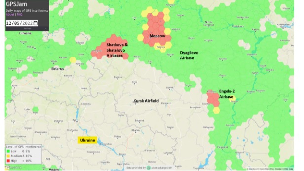
Two Russian airbases deep inside the country were attacked on December 5: the Engels-2 base in the Saratov region and Dyagilevo near Ryazan. The next day an oil tank at the Kursk airfield closer to the border with Ukraine was hit and set on fire.
The Russian government has long interfered with reception of GPS signals, especially near and within its own borders. The early December attacks seem to have motivated an increase in this activity.
More Interference
Information displayed by the website GPSJam.org indicates that, on the first day of the attacks, GPS interference was detected around Moscow, at two airbases to the east, and near the Engels-2 airbase.
Image: RNT Foundation
GPSJam.org uses anomalies in crowdsourced aviation ADS-B data as an indicator of unreliable GPS signals. Note that no such information is available for much of Ukraine as commercial aircraft have been avoiding the airspace since the beginning of the current conflict.
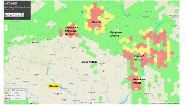
The GPSJam.org depiction of the region six days after the attacks is quite different and has stayed much the same ever since. It seems to show greatly increased interference in the vicinity of the Engles-2 airbase, and new interference around the Marinikova airbase to the south along the Volga River.
Image: GPSJam.org
A History of Jamming and Spoofing
The Russian government has been deliberately and systematically interfering with GPS signals in some places since at least 2016.
The article documented a tech podcaster’s discovery that GPS L2 and L5 signals were being jammed and GPS L1 was being spoofed in the vicinity of the Kremlin. The combination of jamming and spoofing caused receivers in the area to report that, rather than being downtown, they were at the Vnukovo international airport some 20 kilometers away.
The author of the article speculated the spoofing was to protect government officials and buildings from surveillance and attack by UAVs. Since 2013 most larger UAVs have been programmed by manufacturers with the locations of airports and to avoid them. Making UAVs near the Kremlin believe they were at an airport could be an effective part of an overall defense system by causing them to avoid the area.
In 2017 the Resilient Navigation and Timing Foundation examined maritime AIS data and found similar spoofing activity had been occurring in the Black Sea for at least two years. A 2019 report by the nonprofit C4ADS expanded upon this work and revealed spoofing activity at various times and places across Russia. Almost 10,000 instances were documented across ten locations between 2016 and 2018. The report also linked much of the spoofing to the Russian Federal Protective Service and movements of senior government officials. This reinforced the idea that the spoofing was part of VIP protection efforts.
Questions Abound
It is easy to conclude that Russia’s recent increases in interference activity were in reaction to the UAV attacks on December 5 and 6.
Western intelligence and military officials may be arriving at additional conclusions and asking themselves some intriguing questions. One might be why it took six days after the first UAV attack to implement the new interference scheme. The report by C4ADS made it clear that Russian equipment used for wide area spoofing is quite portable.
Perhaps the delay was one of decision making. Some observers have commented that much of the direction for the current conflict comes directly from the top, rather than being delegated to field commanders. It could well be that it took that long for the Kremlin to realize that UAVs were involved and direct equipment to be deployed.
Another question likely being asked is about the selection of locations where interference is being used. Interference activity was observed at the Engels-2 airbase before it was attacked. This seems to have greatly increased after the attack. Airfields at Dyagilevo and Kursk were also attacked, but no interference activity has been observed at either location.
At the same time, substantial new interference activity has been observed at the Marinikova airbase, which was not attacked. There are likely several contributing factors to why some locations have been protected with jamming and/or spoofing and some not.
While Russian forces have a fearsome reputation for electronic warfare and their ability to interfere with GPS signals, the amount of equipment and the number of trained operators may be limited. C4ADS’ finding that spoofing equipment was moved around with VIPs rather than permanently located around the nation could indicate a limited amount.
This would mean that the bases and facilities to be protected must be prioritized. The lack of interference around Kursk and Dyagilevo could mean Russia sees them as less important, or less likely to be attacked again. New interference at Marinikova could mean it is a high value target and in need of protection.
Conversely, some of the new activity could be designed to deceive and draw Ukrainian fire away from higher value targets and toward lower ones. Such is the potential nature of military strategy in war.
Analysts are also probably asking questions about the effectiveness of jamming and spoofing as a defense against a determined UAV-operating opponent.
Interference had been detected at Engels-2 before it was successfully attacked by one or more UAVs. This likely shows that Ukrainian forces disabled any geofencing that might have been originally included as part of the UAVs’ original design. They may have also upgraded the UAVs’ navigation receivers with hardware or software to make them much more resistant to interference from the ground.
Navigation Warfare Increasingly Important
Regardless, the UAV attacks and observed changes in interference activity reaffirm the importance of navigation warfare in modern conflicts. Knowing the location of your forces and of your targets has always been important. In an era of precision strike and autonomous systems, robust and resilient navigation that resists or overcomes interference is even more important.
The U.S. military has long recognized this, establishing its Joint Navigation Warfare Center in 2004. The center focuses on the intersection of positioning, navigation, and timing with electronic warfare and cyber operations. Undoubtedly Russia has identical concerns and probably an equivalent organization.
The current conflict in Ukraine will continue to raise questions for both sides. Not in question, though, is the importance of navigation warfare to this conflict, and that it will be increasingly important in future ones.
Plus: Visual AI radar aids drone searches, and a drone is released into Hurricane Ian
Just when you imagine there couldn’t be any more twists and turns to the war in Ukraine, another one turns up. Some may recall that Estonian security forces caught an Estonian/Russian man trying to send drones to Russia. The Estonian government confiscated the shipment of DJI drones.
Now Estonia has donated those drones to Ukraine for use against Russia in the ongoing war.
Remember the drones we confiscated from a person trying to donate them for the Russian aggression in Ukraine? Well, these drones still made it to Ukraine. But the right way around and on the right side of the battlefront. https://t.co/No38Bbjkom
Some might say that this is an example of, “What comes around goes around.” Nevertheless, everyone respects Russia’s nuclear options…
Making Drones Smart
It’s all well and good that we have all shapes and sizes of battery- and gas-powered drones, ones that take off and land vertically (eVTOL) or horizontally (generally, fixed-wing). But how do we make them smart enough to complete tasks on their own?
Artificial intelligence (AI) could be the answer. Take the Boeing Loyal Wingman drone. It is being developed to fly autonomously alongside high-end fighters, and perhaps to control other drones flying nearby. Those tasks require AI, which is being incorporated into the capabilities of drone systems.
We also have immediate needs, such as search and rescue, security patrol and inspection (for commercial and military facilities, border and crowd control) and military intelligence, surveillance, target acquisition and reconnaissance (ISR/ISTAR). Along comes Sentient Vision Systems of Australia with a passive, software-based “visual radar” solution.
Sentient Vision Systems uses its digital AI processing with existing visual and infrared sensors. This combination can apparently surpass human and conventional radar capability to detect and track small moving objects.
Search and rescue at sea can be a really difficult task for people. It’s not surprising that a lot of lengthy searches end up with zilch. During a search, an aircraft flies from 20,000 feet down to 500 feet over the waves. If you have seen cabin video of air-sea searches in progress, with a searcher gazing out of the aircraft’s window for hours, straining to see something small bobbing in the sea below, it does seem like a herculean task.
As an alternative, take a long-range (>55 nautical miles) drone, such as a Boeing/Insitu ScanEagle. Hook up the scanning search camera and high-resolution nose turret to the vidar (visual detection and ranging) processing.
Boeing/Insitu ScanEagle UAV with vidar pod. (Photo: Insitu)
As a result, you have an autonomous airborne system that can find a person in the water from a distance of about 1.7 nautical miles, and spot a ferry deck from ~30 nautical miles. Insitu claims that conventional radar systems cannot do this. In 12 hours it can search an area of about 13,400 square nautical miles.
Several such sorties might just have found an early trace of Malaysian Airlines Flight MH370 in 2014. The Boeing 777 with 239 people on board disappeared over the South China Sea 38 minutes after takeoff on a flight to Beijing. Over three years, long-range patrol aircraft covered 46,000 square miles before the search was abandoned.
During 2015 and 2016, pieces of the airplane began washing up on the shores of countries on the Western Indian Ocean. The search would probably not have been easy even for a fleet of ScanEagles, considering the logistics and the available range of the unmanned aircraft, but major incidents might find success with vidar-equipped UAVs.
Into the Eye of the Hurricane
The devastation that Hurricane Ian wrought in Southwest Florida has been terrible. A shark swimming up a street in Fort Meyers illustrates the degree of flooding left from landfall of the category 4-5 hurricane.
Ian was the strongest hurricane to make landfall in the United States in decades, with extremely high winds and strong storm surge. I sat through the storm 75 miles to the North, and it was one scary hurricane even there. I can’t sympathize enough with the residents of Lee County, who only received a warning to evacuate one day before it hit them.
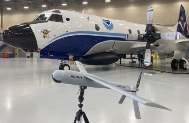
Nevertheless, the National Oceanic and Atmospheric Administration (NOAA) had its Hurricane Hunter Orion aircraft up to investigate on Sep. 28 as the storm came in from the Caribbean. Despite bad turbulence, the P-3 aircraft flew into the upper regions of the Hurricane and launched an Altus-600 27-pound drone into the eye at 4,500 feet. With a 275-mile range at up to 100 mph, the aircraft crew controlled the small drone, using it to collect data on wind speed, pressure, temperature and humidity.
The Orion P-3D Hurricane Hunter aircraft and the Altus-600 drone. (Photo: NOAA)
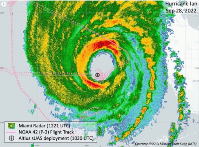
During the two-hour mission, the Altus drone flew into the eye wall, where winds of 187 mph were detected at altitudes between 2,300 and 200 feet. It’s not exactly clear whether the drone survived.
This radar image of Hurricane Ian shows the Altus release point. (Image: NOAA)
While information gathered may have assisted with the immediate forecasting for us Florida folks on the ground, the real scientific value comes from feeding the data into National Hurricane Center models for storm detection and analysis to keep us safer in the future.
Wrap up
To sum up, this month we saw drones destined for Russia sent to Ukrainian forces. Vidar artificial intelligence on Insitu ScanEagle drones promises huge gains for search and rescue. And, once again, a NOAA crew flew directly into the eye of a hurricane, this time releasing a drone to aid in gathering essential storm data.
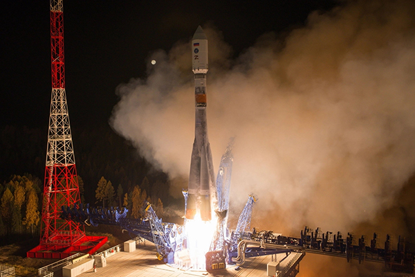
A Fregat booster successfully delivered a Glonass-K navigational satellite into its designated orbit, Russia’s Defense Ministry reported on Oct. 10. Glonass-K No. 17L is the fifth K satellite to join the constellation.
“A Soyuz-2.1b medium-class carrier rocket that blasted off at 05:52 a.m. Moscow time on October 10 from the Plesetsk spaceport in the Arkhangelsk Region successfully delivered a Russian Glonass-K navigational satellite into the target orbit at the designated time,” the ministry said in a statement.
Liftoff and the delivery into the designated orbit proceeded in normal mode, the ministry said, and the ground-based facilities of Russia’s Aerospace Forces assumed control.
“The Russian Glonass-K navigational space vehicle launched on Monday, October 10, from the Plesetsk spaceport by a combat team of the Space Troops of the Aerospace Forces was delivered into the target orbit at the designated time and placed under the control of the ground-based facilities of the Titov Main Testing Space Center of the Aerospace Forces’ Space Troops,” the statement said.
Stable telemetry communications have been established and are being maintained with the satellite. The space vehicle’s onboard systems are operating in normal mode, the ministry said.
The Glonass-K is a third-generation satellite of the Russian global navigation satellite system (Glonass). The satellite was engineered and manufactured by the Reshetnev Information Satellite Systems Company (part of Russia’s State Space Corporation Roscosmos). The satellite was developed to replace the Glonass-M family of space vehicles.
“Seen & Heard” is a monthly feature of GPS World magazine, traveling the world to capture interesting and unusual news stories involving the GNSS/PNT industry.
Photo: Space Norway
Norway to get radar assist
Norway’s sea areas are seven times larger than its land area. Now the country is creating a radar satellite system to surveil and locate ships in waters of interest, including the High North. On Aug. 25, Space Norway signed contracts with vendors to build the MicroSAR system, which will launch in 2025. Plans are to make a constellation of radar satellites that can detect small vessels in a large area simultaneously. While the system will use GNSS for orbit tracking, the radar function is independent of GNSS during acquisition. This will solve a flaw in the Automatic Identification System (AIS) now used for maritime surveillance — estimates are that 5% of vessels either do not send out AIS information or are transmitting false information.
Photo: Yandex
Russia’s driverless autos hit the brakes
Russian driverless projects are facing hurdles following the invasion of Ukraine, reports TU-Automotive. For instance, Russian IT giant Yandex had hoped to launch robo-taxis in the United States but has suspended street tests and robotic delivery pilots and laid off employees in its U.S. office. Russian freight carriers are experiencing a shortage of new vehicles and spare parts from Western trade sanctions and countermeasures by the Russian government. Meanwhile, Russia’s pilot tests of connected road infrastructure are still taking place, according to V2X vendor Sreda Software Solutions.
Nathaniel Frissell and team. (Photo: University of Scranton)
Bunches of grapes
A University of Scranton collaborative research project will use daily Doppler shift receiver measurements to study how dawn, dusk and solar eclipses affect the ionosphere. The team, led by Nathaniel Frissell, will use a network of GNSS-stabilized and synchronized high-frequency receivers known as Grapes, developed as part of another National Science Foundation project in 2019. The last solar eclipses to traverse the continental United States until 2044 will occur Oct. 14, 2023 and April 8, 2024. “This project takes advantage of the unprecedented opportunity to study the ionospheric impacts of the 2023 and 2024 solar eclipses and the daily ionospheric variability associated with dawn/dusk transitions,” Frissell said. A better understanding of the effects of ionospheric disturbances is imperative, because the changes affect GNSS navigation and communications systems.
Screenshot: Anonymous TV
Moscow navigation fail
The hacker collective Anonymous managed to disrupt Yandex’s Moscow taxi fleet on Sept. 1, sending dozens of taxis to an address on Kutuzovsky Prospekt. The hacking caused a two-hour traffic jam in the center of Moscow near the Stalinist-era building Hotel Ukraina (Hotel Ukraine), now a Radisson. Hackers likely bypassed Yandex’s safety measures, creating multiple fake orders that prompted drivers to simultaneously go to the same location.
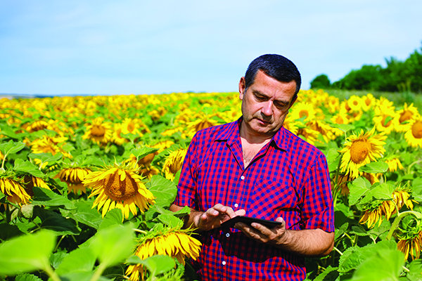
Sunflowers — soniashnyk in Ukrainian — have been grown in Ukraine since the mid-18th century. Besides being a popular snack, growing the flower for export helps fuel Ukraine’s economy. Before the war, Ukraine and Russia supplied up to 80% of the world’s sunflower oil exports.
With the Russia invasion, however, sunflower and other crops have suffered, with growth of spring crops declining as much as 40% in the eastern Donbas region hit especially hard by the war.
OneSoil Map, by OneSoil, is a new, powerful data visualization and mapping tool that combines proprietary artificial intelligence (AI) with satellite imagery to map crops worldwide. It enables agricultural businesses to visualize massive datasets and deliver insights on a global scale. Another tool, the OneSoil application, helps farmers remotely monitor crop health, detect issues and apply fertilizers and seeds, increasing yields and boosting sustainable farming practices.
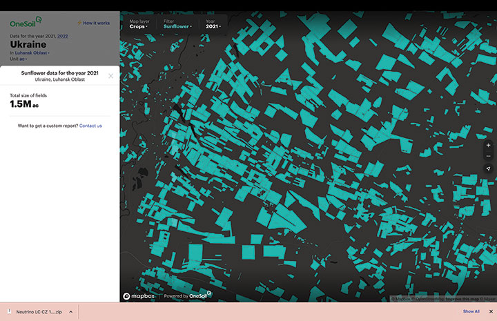
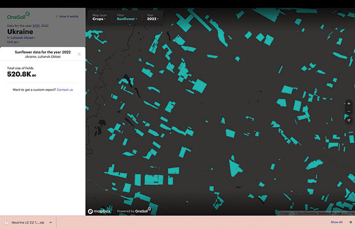
In Ukraine, satellite imagery and AI-based technologies are helping farmers face shortages and a population confronting food insecurity. OneSoil compared 2021 and 2022, and foundthe area used for the country’s spring crops— corn and sunflower— have decreased by 40% in wartorn regions, with the greatest decrease in Kharkiv (–59%), Donetsk (–58%), Luhansk (–57%) and Zaporizhia (–43%).
Corn is an export crop that accounts for 16% of the global market. OneSoil Map showed its overall acreage in the main corn production areas (Chernihiv, Poltava, Sumy) has dropped by 19% to 36%, depending on the region.
The above sample of sunflower crops in the Luhansk Oblast region — part of the wartor — shows the decrease in crop fields from 2021 (top, 1.5M acres). (Image: OneSoil)A sample of sunflower crops in the Luhansk Oblast region — part of the wartorn Donbas — shows the decrease in crop fields in 2022 (520.8K acres). (Image: OneSoil)
“Seen & Heard” is a monthly feature of GPS World magazine, traveling the world to capture interesting and unusual news stories involving the GNSS/PNT industry.
Xona’s first demonstration mission successfully completed testing at Experior Laboratories and prepares for launch on a Falcon 9 in May. (Photo: Xona)
TAKING GNSS PRIVATE
At press time, Xona Space Systems’ first in-space demonstrator satellite, named Huginn, was ready to launch on May 25 aboard Space X’s Transporter 5 mission. Xona said the launch is a significant step toward realizing its high-performance commercial navigation system, a constellation of small, powerful satellites in low Earth orbit that will meet the navigation and timing needs of intelligent systems.
U.S. cellular carrier AT&T is rolling out location-based routing to automatically transmit wireless 9-1-1 calls to the appropriate call centers, rather than relying on which cell tower handles the call. Cell towers can cover a 10-mile radius, and overlap with more than one call-center boundary. With location-based routing, a device can be located and routed within 50 meters of the device location. The “Locate Before Route” feature from Intrado enables AT&T to use device GNSS and hybrid information to route the call to the right call center.
Russian jets have been found using GPS receivers, while ground vehicles use paper maps, according to the UK Express. The GPS receivers were found taped to the dashboards of Russian SU-34s downed in Ukraine because of “the poor quality of their own systems,” UK Defense Secretary Ben Wallace said in a speech. With many reports of maintenance and aging issues for the Russian military, most likely the jets did not have quality GNSS receivers rather than the fault lying with GLONASS.
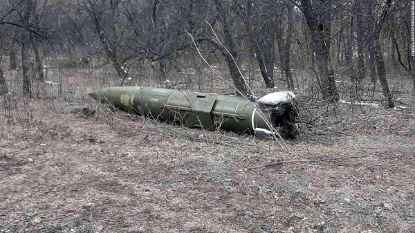
A Russian short-range ballistic missile, believed to be an unexploded Iskander missile, was found near Kramatorsk, Ukraine, in this photo released March 9 by Ukrainian authorities. (Photo: National Guard of Ukraine handout via Reuters)
UNEXPLODED BOMBS MAPPED
The HALO Trust is partnering with Esri to map unexploded ordnance in an immediate humanitarian response to the war in Ukraine. More than 10 million Ukrainians have been displaced by the war and many are forced to move across a landscape littered with unexploded rockets, bombs and landmines. In response, Esri has committed its cutting-edge geographic information system (GIS) software resources, expertise and staffing in support of HALO’s mission in Ukraine. HALO already is using GIS to map the heaviest conflict zones, and the partnership with HALO will support planning for future clearance operations.
As PNT becomes critical to more economic activities, any disruption in availability, reliability, resilience and integrity would weaken the critical infrastructure that sustains national security, business operations and public safety, according to experts speaking at the Geospatial World Forum.
This growing dependency on PNT services — and the potentially high economic cost of vulnerabilities — underscores how vital GPS and GNSS systems are to the global economy and national security of countries worldwide, the experts said. Resilient PNT systems are necessary to combat GPS/GNSS outages.
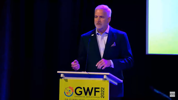
Robert Cardillo (Photo: GWF)
Building resilience into these systems will require multiple technologies ranging from network time-transfer services to terrestrial wireless infrastructure and low-Earth-orbit (LEO) satellites.
The Geospatial World Forum opened in Amsterdam on May 10. The second plenary of the day focused on the value of PNT in the global economy. Geospatial World is a global think tank working towards raising awareness around the use of geospatial data and technologies among governments and policymakers, businesses, and the public at large.
Robert Cardillo, president of The Cardillo Group and former director of the U.S. National Geospatial Intelligence Agency (NGA), headed the panel of experts.
“Our existence on this planet has been shaped by our individual and collective awareness of place and our confidence to be able to move securely and efficiently from one place to another, all within that common framework of position, navigation and timing, or PNT,” he said.
“The smartphone is a wonderful example of how far PNT has been integrated into our lives,” said Trimble founder Charlie Trimble. He laid down three basic phases involved in leading PNT to its place in the world economy.
“The path from the dawn of space age to the smartphone was anything but obvious or straightforward,” Trimble said. “First, Sputnik led to the global navigation systems. Second, the Shuttle disaster led us to the realization that the satellite system was an information utility. And now, the integration of PNT into the mobile and immobile internet is changing our world.”
From left: Charlie Trimble, Martin Sweeting, Rodrigo da Costa and Gillian Smith. (Photo: GWF)
“Our first contract was with ESA (European Space Agency) to look at the feasibility of using a navigation and timing satellite using small-satellite techniques, which in 1985 was considered a wacky idea,” recounted Martin Sweeting, executive chairman of Surrey Satellite Technology Ltd. “At ESA, we have embarked on a project called Hydro GNSS, which uses Surrey’s GNSS reflectometry to address several climate related issues, be it water detection or biomass, etc. This doesn’t stop here; we are looking at the lunar economy. PNT has indeed a very bright future, not just on Earth but also looking through this decade into the use of PNT on the lunar surface.”
Rodrigo da Costa
“New things are happening, particularly in the area of governmental satellite communications, space situational awareness and others, which are benefitting citizens every day,” said Rodrigo da Costa, executive director, EU Agency for the Space Programme (EUSPA). “Galileo, EGNOS (European Geostationary Navigation Overlay Service), Copernicus and GOVSATCOM programs are key areas of EU space activities. All these programs are massive investments and in the end, the result comes from their utilization in the different areas of our economy and daily life.”
“Just in the United States alone, GPS is approaching USD 1 trillion in terms of economic impact and is doubling every 2-3 years. But it is a single point of failure. This highlights the need for resilient PNT,” said Gillian Smith, vice president of marketing, NextNav. “We believe that our needs have evolved beyond technology that was really created in the ’60s. We need increased accuracy and availability in the urban environments in particular.
“I think many of you have experienced it if you’ve tried to use it in any major city,” Smith said. “That blue dot is going to bounce off of buildings and not be very accurate. We need indoor tracking and mapping. We need altitude data so that you know what floor you’re on when you’re thinking about accurate location. We also need to increase resilience and redundancy. That’s going to give us all increased security as well.”
The Value of GPS
GPS jamming and interference is a grave issue that has come under the spotlight particularly since the Russian invasion of Ukraine, according to Geospatial World.
In 2019, a Washington, D.C., think tank documented more than 10,000 cases of GPS interference (jamming and spoofing) in the previous five years from Russia. By 2021, these had become increasingly sophisticated. In a peculiar case, the crew onboard NATO ships in Odessa saw their position being given as Crimea.
In the past six months, even before the war on Ukraine began, there were reports of GPS jamming in and around that region. In March, the EU Aviation Safety Agency had issued warnings of GNSS spoofing and jamming for flights over Europe, in particular around countries neighboring Ukraine and Russia.
Globally, the economic impact of GPS/GNSS disruption is difficult to state. The potential economic consequences of failing to sufficiently protect sources of PNT are enormous, with estimates ranging from millions to billions of dollars depending on the type, length, severity and geographic scope of the disruption.
Furthermore, the impact of a GPS/GNSS outage extends beyond basic economics and could result in risk to life. Emergency services, distress beacons and telecommunications networks all rely on PNT services — any disruption could cause serious consequences.
A 2019 report sponsored by the National Institute of Standards and Technology estimated that the loss of GPS would cost the U.S. economy USD 1 billion a day.
A 2017 study in the United Kingdom estimated a five-day GNSS disruption would lead to an economic impact of GBP 5.2 billion (USD 7.2 billion), with road, maritime and emergency service impacts accounting for 88 percent of the cost.
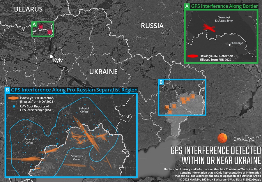
Technology from HawkEye 360 Inc. has detected and geolocated extensive GPS interference over Ukraine, starting months before the Russian invasion. HawkEye 360 uses satellites to monitor radio-frequency signals that might threaten military and civil navigation applications.
The capability was tested in 2021 in a variety of exercises and is available as part of HawkEye 360’s RFGeo signal product catalog.
When HawkEye 360 analysts examined Ukraine over the past five months, they discovered continued and increased GPS interference across the region. The data showed extensive GPS interference in November 2021 along the boundary of the pro-Russian separatist-controlled regions in Luhansk and Donetsk.
Open-source information confirmed unmanned aerial vehicles (UAVs) operating in the area were disrupted because of lost GPS connections.
In February 2022, HawkEye 360 detected GPS interference along the border between Ukraine and Belarus, shortly before the Russian invasion started. This February activity occurred north of Chernobyl within the Chernobyl Exclusion Zone, demonstrating the integration of electronic warfare tactics into Russian military operation to further degrade Ukraine’s ability for self-defense.
“GPS is a fundamental ‘global commons’ service that all modern economies depend upon. GPS signal interference has the potential to significantly disrupt air travel, logistics, finance, transportation, communication and many other basic services,” said John Serafini, CEO of HawkEye 360.
“Whether unintentional or deliberate, interference that prevents people, vehicles, ships, and planes from determining accurate locations can be devastating to government and commercial activities alike,” Serafini said. “Since HawkEye 360 can monitor hundreds of millions of square kilometers daily, we are able to notify clients when and where GPS interference occurs, so they can respond quickly to mitigate the impacts.”
Interference can be inadvertent by equipment operating too close to GPS frequency bands. However, deliberate interference has spiked across the globe due to the low cost, ease of deployment, and general availability of GPS jamming technology.
Military forces use GPS jammers to obscure and protect critical troops, facilities and equipment from attack and can be a leading indicator of future military activity. Drug cartels use GPS jammers to deter surveillance from overhead drones. Use of jammers is illegal in most developed nations.
HawkEye 360’s detection product offers a valuable capability to monitor for illicit and unintentional GPS interference that can significantly disrupt critical location services, representing the company’s global commitment to make the world a safer place, the company said.
Russia’s brutal aggression on Ukraine changed the world in a few days. Devastation and displacement in Europe already are on a scale unseen since World War II, and the risk of a catastrophe greater by orders of magnitude has not been as high since the Cuban Missile Crisis of 1962, the year I was born. Given the long production timeline of a monthly magazine, I will not venture a guess as to what the headlines will be on the day you read this.
The Russian assault has sharply raised concerns about GNSS vulnerabilities. In a March 17 bulletin, the European Union Aviation Safety Agency (EASA) warned of a GNSS outage leading to the degradation of navigation and surveillance. Reports analyzed by EASA indicate that since Feb. 24, GNSS spoofing and jamming has intensified in the Baltic Sea, neighboring states, Eastern Finland, the Black Sea and the Eastern Mediterranean. “The effects of GNSS jamming and/or possible spoofing,” the bulletin stated, “were observed by aircraft in various phases of their flights, in certain cases leading to re-routing or even to change the destination due to the inability to perform a safe landing procedure.”
Russia already has aided in the proliferation of handheld GPS jammers, the deployment of road-mobile jammers, and even development and testing of space-based jammers. Now, it could turn its substantial cyberspace hacking capability against the ground-control segments of GPS and Galileo.
When Russia tested an anti-satellite weapon on Nov. 15, 2021, the Kremlin claimed on state television that this capability “means that if NATO crosses our red line, it risks losing all 32 of its GPS satellites at once.” This threat was particularly dangerous because GPS satellites carry, as a secondary payload, the U.S. nuclear detonation detection system.
At a panel discussion about resilient GPS that I moderated at the International Wireless Communications Expo in Las Vegas on March 24, Diana Furchtgott-Roth, an adjunct professor at George Washington University and former deputy assistant secretary for Research and Technology at the U.S. Department of Transportation (DOT), titled her presentation “Russia Proves America Needs Backup GPS.” She cited the National Defense Authorization Act of 2017, the National Defense Authorization Act of 2018, and the National Timing Resilience and Security Act of 2018, which instructed DOT to provide a complement and backup for civilian GPS. The legislation required the Secretary of Transportation to put in place a backup system for GPS by the end of 2020, subject to congressional appropriations. However, she pointed out, these funds have not yet materialized.
Multiple technologies can and should be used to complement GPS. Several of them are mature and commercially available, including signals from low Earth orbit satellites and terrestrial broadcast stations.
Meanwhile, the United States should accelerate the launch schedule for GPS III satellites already produced. They provide better accuracy, anti-jamming capabilities, and opportunities for civilian connectivity that could offer critical assistance to its European allies.
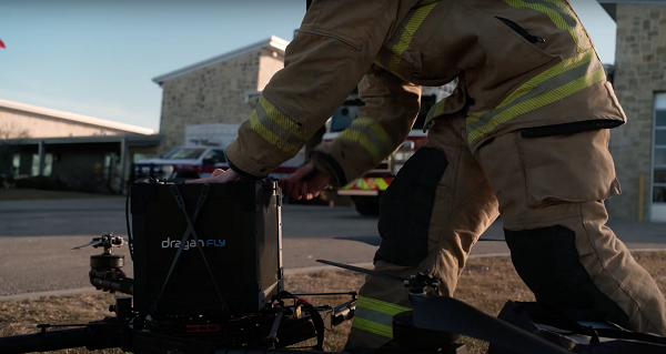
The first Draganfly humanitarian drone shipped to Revived Soldiers Ukraine (RSU) has arrived in Europe and will soon deliver insulin to hard-to-reach hospitals in Ukraine. Draganfly is a North American drone manufacturer.
RSU ordered 200 Draganfly medical response drones equipped with temperature-managed payload boxes that can transport up to 35 pounds of blood, pharmaceuticals, insulin/medicines, vaccines and wound-care kits. Because insulin is a temperature-sensitive product, quick and safe transportation of the hormone is a top priority.
About 2.3 million people in Ukraine live with diabetes. Many are Type 1 diabetics who need multiple daily injections of insulin to survive. For those living in high-conflict areas of the country, access to life-saving insulin is limited or non-existent.
NuGen Medical Devices donated the needle-free injection devices and 5,000 needle-free disposable syringes to be filled with insulin. Not only are life-saving medical supplies like insulin dwindling in Ukraine, but there is also an urgent need for many medicines across the country as hospitals have been under direct attack since Russia invaded on Feb. 24.
Draganfly medical relief drone. (Photo: Draganfly)