Photo: Stanislav Ostranitsa/iStock/Getty Images Plus/Getty Images
Is Russia’s recent threat to destroy GPS satellites technically realistic? Specifically, how many satellites would it have to destroy to essentially incapacitate GPS-dependent U.S. weapons systems? Would the 1,100-km separation between the orbits of GPS and GLONASS satellites spare the latter from the debris field?
Ellen Hall
“It appears technically possible because they destroyed one of their own retired Soviet satellites on Nov. 15 with anti-satellite technology. Russia threatened to destroy up to 32 satellites, which would incapacitate GPS-dependent weapons and create a virtual mine field of debris with little ability to project trajectories of debris fallout. It is imperative that LEO and ground-based sensor alternatives be developed that will make an enemy attack less likely to be incapacitating.” — Ellen Hall, Spirent Federal Systems
“Some still appear to believe that the number of satellites and their orbital height offer some level of protection. They refuse to look to the ground for resilient solutions using proven and highly reliable technology — which, coincidently, both Russia and China continue to operate as their resilient PNT solutions. The United States and its allies cannot continue to be dictated to by financial analysts who resist these solutions for fear of exposing the poor decisions they supported in the past and continue to support regarding a solution with a higher power and low frequency.” — Mitch Narins, consultant
Bernard Gruber
“Yes, it is technically realistic, but this act of war against a truly worldwide utility would be politically and economically disastrous. GPS IOC was based upon 24 MEO satellites that offered full, but not overlapping, worldwide coverage with spares — there are now 31 satellites that can be utilized through the control segment. The GPS constellation is ~1,100-km deeper than GLONASS. As made evident by the now-destroyed Kosmos 1408 debris cloud simulations, and the actual debris cloud spread by the Chinese 2007 ASAT test that now encompasses most of the LEO regime, the debris field will expand, thus increasing risk to GPS satellite placement and possibly risking physical damage to currently orbited satellites.” — Bernie Gruber, Northrop Grumman
“Seen & Heard” is a monthly feature of GPS World magazine, traveling the world to capture interesting and unusual news stories involving the GNSS/PNT industry.
Photo: lindsay_imagery/E+/Getty Images
Where Sea Turtles Nest
Florida’s Sea Turtle Grants Program — funded with proceeds from special license-plate sales — were used to purchase Trimble TDC100 and TDC600 handheld GNSS receivers for state park staff to gather data about turtle nesting activity. The staff also uses Esri’s ArcGIS Survey123 field-capture software to report on turtles using the 108 miles of beach in 40 of Florida’s state parks. Negative impacts from commercial fishing, plastic waste and climate change have become a threat to sea turtles, which are now classified as an endangered species.
Concept of vertiport at airport. (Groupe ADP)
Paris up in the Air
Paris has begun testing electric air taxis at a new site outside the French capital, with an eye toward creating at least two demonstration flight paths during the 2024 Olympics to ferry passengers from nearby airports. Inaugurated in November, the test site is dedicated to new sustainable urban air mobility, and will study the use of electric vertical take-off and landing (eVTOL) aircraft. Choose Paris Region, Groupe ADP and RATP Group are managing the effort with VoloCity taxis by Volocopter onboard.
Photo: Stanislav Ostranitsa/iStock/Getty Images Plus/Getty Images
Russia Threatens GPS
The Kremlin warned it could blow up 32 GPS satellites with its new anti-satellite technology (ASAT), which it tested Nov. 15 on a retired Soviet Tselina-D satellite, according to numerous news reports. Russia then claimed on state television that its new ASAT missiles could obliterate NATO satellites and “blind all their missiles, planes and ships, not to mention the ground forces,” said Russian Channel One TV host Dmitry Kiselyov, rendering the West’s GPS-guided missiles useless. “It means that if NATO crosses our red line, it risks losing all 32 of its GPS satellites at once.”
Bali toll gate. (Photo: dwart/iStock/Getty Images Plus/Getty Images)
Indonesia Goes Cashless
Indonesia’s GNSS-based cashless toll system will take effect by the end of 2022, reports Indonesia Expat. The country’s Public Works and Public Housing Ministry plans to have its multi-lane, free-flow-based non-cash toll transaction system implemented on 40 toll roads on the islands of Java and Bali. MLFF uses GNSS plus a map-matching process and special toll road apps on smartphones to determine fees. The system is expected to increase efficiency, effectiveness, security and convenience in conducting toll road payment transactions.
Russia warned it could blow up 32 GPS satellites with its new anti-satellite technology, ASAT, which it tested Nov. 15 on a retired Soviet Tselina-D satellite, according to numerous news reports.
Russia then claimed on state television that its new ASAT missiles could obliterate NATO satellites and “blind all their missiles, planes and ships, not to mention the ground forces,” said Russian Channel One TV host Dmitry Kiselyov, rendering the West’s GPS-guided missiles useless. “It means that if NATO crosses our red line, it risks losing all 32 of its GPS satellites at once.”
The International Space Station (ISS) Flight Control team was notified of indications of a satellite breakup, causing 1,500 pieces of debris to threaten the station. “Due to the debris generated by the destructive Russian Anti-Satellite (ASAT) test, ISS astronauts and cosmonauts undertook emergency procedures for safety,” said NASA Administrator Bill Nelson.
“With its long and storied history in human spaceflight, it is unthinkable that Russia would endanger not only the American and international partner astronauts on the ISS, but also their own cosmonauts,” Nelson said. “Their actions are reckless and dangerous, threatening as well the Chinese space station and the taikonauts on board. All nations have a responsibility to prevent the purposeful creation of space debris from ASATs and to foster a safe, sustainable space environment.
“Russia has demonstrated a deliberate disregard for the security, safety, stability and long-term sustainability of the space domain for all nations,” Gen. James Dickinson, commander of U.S. Space Command, said. “Russia’s tests of direct-ascent anti-satellite weapons clearly demonstrate that Russia continues to pursue counterspace weapon systems that undermine strategic stability and pose a threat to all nations.”
Photo: Stanislav Ostranitsa/iStock/Getty Images Plus/Getty Images
Russia has postponed the launch of its first next-generation Glonass-K2 satellite until early in 2022, according to a report from TASS. The launch was originally scheduled for the fourth quarter of this year. The delay is due to a portion of onboard equipment requiring further work following a ground-based test run.
Glonass-K2 is the next-generation navigation satellite of Russia’s GLONASS positioning system. The K2 satellites are expected to provide navigation precision of less than 30 cm.
Two recent reports from the Organization for Security and Co-operation in Europe (OSCE) have described a recent increase in GPS jamming, presumably by Russian or pro-Russian forces in Ukraine. This comes as Russia has increased its troop numbers and activity along its border with Ukraine.
OSCE is charged with a Special Monitoring Mission (SMM) in Ukraine which observes and reports on how well both sides are adhering to the Minsk Protocol agreement. The agreement was signed in September 2014 by participants in the conflict in an effort to end open hostilities.
One of the ways the OSCE mission monitors activity and compliance in the region is with long range UAVs. As early as November 2014, the organization reported UAV operations being thwarted by interference with GPS signals.
Two recent OSCE spot reports have highlighted a resurgence in jamming.
An April 7 report described interference that prevented a UAV takeoff the previous day. While the organization’s UAVs had been experiencing increased interference since March, this was the first time since October 2014 that it had thwarted a mission before takeoff.
The report also documented an increasing level of jamming activity.
“Over the last two months, 62.5 percent of SMM long-range UAV flights encountered GPS signal interference and on 75 percent of the affected flights it occurred more than once.”
A second report on April 9 outlined continuing problems that caused missions to be aborted. It emphasized that this was a violation of the agreement signed by all parties and greatly hampered OSCE’s mission.
“Any GPS signal interference hinders the Mission’s ability to conduct effective monitoring and reporting of the security situation in line with its mandate. Long-range UAVs are an essential part of SMM operations, especially at night and in areas where the Mission’s monitoring and freedom of movement are restricted.”
GPS jamming and spoofing are important parts of Russia’s arsenal to counter any technological advantage the west may have over their forces. A 2015 Sputnik article bragged their electronic warfare kept U.S. cruise missiles from hitting their targets at the start of the 2003 invasion of Iraq. Also, that this advanced capability “renders aircraft carriers useless.”
Interference with GPS signals is a regular feature of Russian military and internal security operations.
The United States has formally expressed concerns about the recent increase in the number of Russian troops and their activity at the Ukrainian border. It has been reported that two U.S. Navy ships are on their way to the Black Sea to help monitor the situation.
Dana A. Goward is president of the Resilient Navigation and Timing Foundation.
Zala Aero Group unveiled the ZX1, a new hybrid unmanned aerial vehicle (UAV), at the 2021 International Defense Industry Exhibition (IDEX) and Conference, which opened on Feb. 21 in Abu Dhabi.
The new drone has vertical-takeoff-and-landing (VTOL). According to Zala, it combines the best qualities of fixed-wing and multirotor types of UAVs; its configuration can change depending on the conditions of the performed task.
Ease of operation allows the UAV system to reduce the operator’s role, decrease the amount of equipment used when performing a flight mission, and fully automate flight processes of the UAV.
The ZX1’s onboard computer uses artificial intelligence, which makes it possible to process data in full high-definition, and transmit HD video and photos via encrypted communication channels to the GCS, ensuring the effectiveness of monitoring even before the aircraft lands.
The VTOL design makes it compatible with existing ZALA payloads, and also allows the installation of additional surveying equipment. It can be used to perform air monitoring for the fuel and energy sector and search-and-rescue operations from sites in urban environments.
Zala Aero Group, founded in 2004, is a Russian developer and manufacturer of unmanned aerial systems, payloads and mobile systems. It is now part of Concern Kalashnikov. Its main products are reconnaissance unmanned systems and digital solutions. Currently, more than 2,000 of Zala UAS operate within Russia. Areas of application are the protection of state borders, reconnaissance and rescue operations, monitoring of high-risk facilities and emergencies.
The Empire State Building sits atop a massive and solid foundation that hardly anyone ever sees. Above ground it has 2.8 million square feet of offices and hundreds of businesses. It houses 15,000 workers. Yet it would all come crashing down if the underlying and unseen foundation weren’t incredibly strong and dependable.
Timing is the unseen foundation of every networked technology, digital broadcast, financial transaction, electrical grid management and of most navigation systems, just to name a few applications. Yet, as GPS World readers know, signals from our dominant source of timing — GPS — are very faint and easily disrupted.
Short term, localized disruptions happen all the time, and many systems have adapted. A delivery driver using a jammer to hide from his boss is unlikely to disrupt a cell base station as he passes by, for example.
Photo: Georgijevic/E+/Getty Images
But more serious threats are out there. More and more hobbyists are finding ways to spoof receivers. Every few decades the sun flares strongly enough to fry satellites or charge the ionosphere. And because there are so few alternatives, GPS and other GNSS have become huge, tempting targets for adversary nations, terrorists, and sophisticated hackers.
Instead of Manhattan bedrock, our timing foundation is sometimes more like shifting sands.
Systems engineering tells us that, if something is essential, there ought to be two, three or more independent ways of receiving it. Most aircraft, for example, have two or three systems powering the flight controls — because controlled flight is important!
The white paper “A Resilient National Timing Architecture” outlines how the United States can leverage existing infrastructure and provide all citizens two, and many of them three, independent paths to coordinated universal time (UTC).
It proposes a national timing back- bone of mature technologies with very different failure modes — GNSS, eLoran and fiber. This combination will provide rock-solid timing at the 500 ns or better level of accuracy relative to UTC everywhere across the nation, and at 100 ns or better in major metro areas. Users accessing two or more systems would be nearly bulletproof to timing service disruptions.
The National Timing Resilience and Security Act of 2018 mandated a terrestrial system to back up GPS timing. Our white paper provides a path forward.
Complying with the law while benefiting current and future technologies should be sufficient motivation. If it isn’t, we must also realize that not acting on this will continue to place us behind other nations such as the United Kingdom, South Korea, Russia and China — all of whom are actively reinforcing their national timing systems.
The task will not be a simple one. Yet America was able to overcome the expense and difficulties of building GPS, at the time the world’s most refined and complex technology, and put it in space. By comparison, establishing a resilient national timing architecture using existing technology in our homeland would be child’s play.
Timing is essential. It is infrastructure for our infrastructure. If our national timing is weak, so is everything that is built upon it.
We will profit from ensuring our timing is as strong, resilient, and easily accessed as possible.
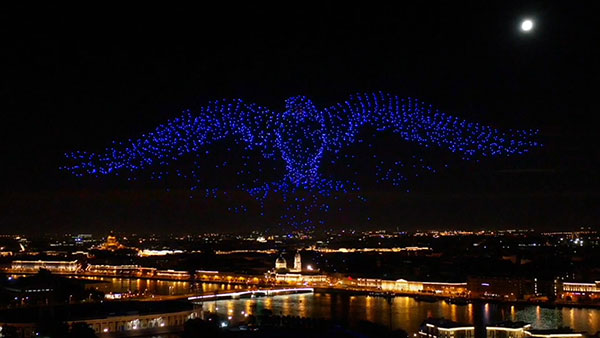
The 10-minute-long drone show included a flying dove with a wingspan of 600 meters, visible from three kilometers away. (Photo: u-blox)
U-blox supplied the high-accuracy technology that made it possible to fly a massive swarm of drones. The simultaneous flight of 2,198 miniature unmanned aerial vehicles (UAVs) was launched into the night sky over Saint Petersburg, Russia, on Sept. 3.
The 10-minute-long drone show included a flying dove with a wingspan of 600 meters, visible from three kilometers away.
Geoscan, which built and programmed the drones and ran the display, chose u-blox positioning technology for its combination of accuracy, reliability, performance and ability to access positional data from both the GLONASS and GPS satellite navigation constellations.
The 10-centimeter-wide Geoscan Salute drones were designed for use in group flights and drone shows. The drones use u-blox NEO-M8P high-precision GNSS modules to provide the positioning data to create a fluid drone show. Salute drones return to their base stations automatically at the end of a show.
The NEO-M8P module implements a real-time kinematic (RTK) approach that improves positional accuracy by comparing the phase of a signal being broadcast from a positioning satellite with that of the same signal that has been received and rebroadcast from a fixed base station. The accuracy gained in this way enables drones to calculate their relative positions to within millimeters, and their absolute positions to within 1 centimeter of the intended position.
Geoscan has been producing drone displays for the past two years, starting with 40 drones flying at once. “The u-blox modules in our Geoscan Salute drones have improved our drones’ positioning accuracies to about one centimeter, and have helped reduce pre-launch preparation time,” said Semen Lapko, head of Drone Show Project, Geoscan. “Drones now move more quickly and accurately, while also operating more efficiently.”
The Russian Defense Ministry has tested new ammunition for its Tornado-S missile system, which is delivered via the multiple launch rocket system (MLRS), reports Russian newspaper Izvestia. Tornado-S is an ultra-long-range missile with a previous flight.
The new MLRS is equipped with GLONASS signal reception equipment and an automated guidance and fire control system. The operator can enter coordinates into the system and give the command to set the guides and open fire. In addition, the system can itself receive and process information from reconnaissance vehicles and drones. For each missile, both range and azimuth angle can be set. The MLRS can launch 12 missile at once.
Previously, the declared flight range of the Tornado-S missiles was about 120 km. Distance with the new ammunition was not disclosed, but the goal was 200 km. The main feature of the missiles is the ability to turn on the target after launch.
The Russian Army was expected to receive 30+ Tornado MLRS this year.
On Oct. 24, 2019, representatives from 11 nations met in Moscow and agreed to a “Radio Navigation Development Plan for Participating Commonwealth of Independent States for 2019 to 2024.” The Russian version is here; a version in English produced by Google Translate can be found here.
Most government documents like this, regardless of the country, tend to be more overviews of current systems vice real plans for a way forward. In this case, though, this seems to be much more of a plan. It documents existing systems, recent accomplishments, user needs, and the upgrades and changes required to meet those needs.
The plan makes clear Russia’s significant concern with GNSS signal disruption (one might opine this is justified as they disrupt the signals so much themselves). As a result, the plan dedicates significant space to combatting disruption and making users more resilient by integrating space and terrestrial systems into a more robust and resilient PNT architecture.
It also seems to confirm a mobile terrestrial PNT capability, likely for military use, that has received little public attention.
Note on Translation and Terminology: The copy of the plan we found was in Russian. We used Google Translate to create an English version. One translation issue that we noticed was several variations of the way the Russian terrestrial Loran PNT system is described. The Russian Loran system is named “Chayka,” literally “Seagull” in English. References in the translated version to “Chaika,” “Loran,” “Laurent,” “Seagull” and “Tropic” are all some version of “Loran.”
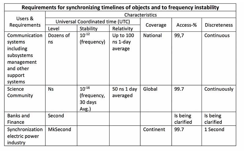
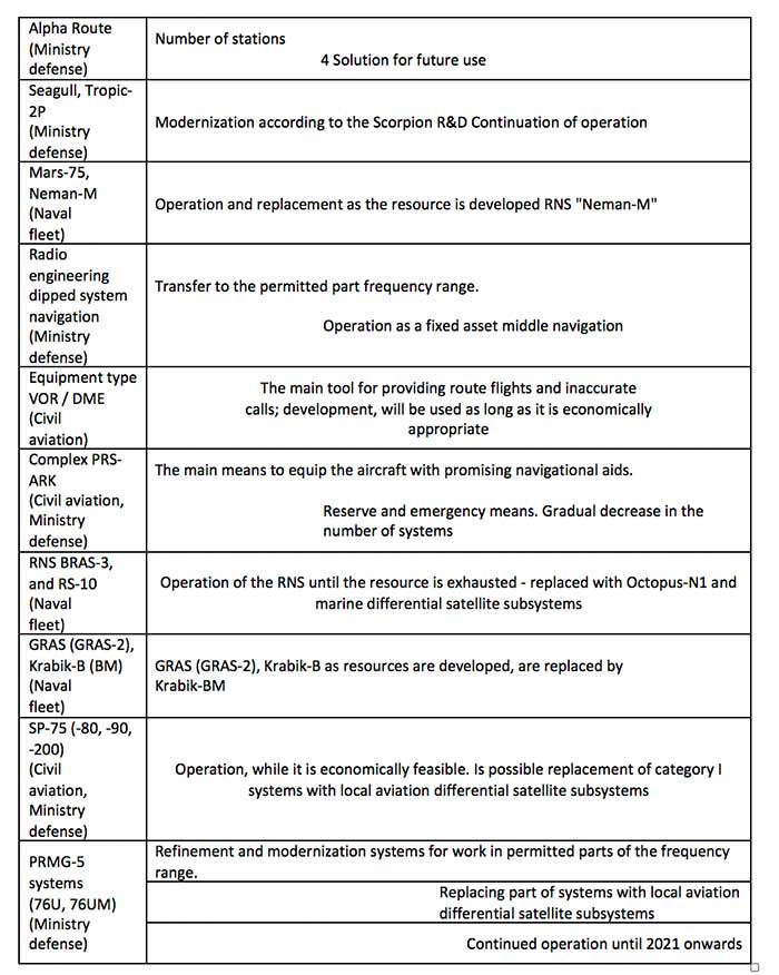
User requirements
Early on the plan provides a detailed discussion of user requirements for each mode of transportation and for timing users. This user focus continues throughout the document. The table for timing users did not transition well during conversion of the document to English and is reproduced below:
Click to enlarge. (Source: “Radio Navigation Development Plan for Participating Commonwealth of Independent States for 2019 to 2024”)
Strategic approach
While not overtly stated, one can see that Russia and its Commonwealth of Independent States (CIS) partners have a very strategic view of PNT and how they can leverage it.
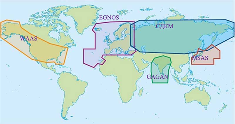
Click to enlarge. (Map: “Radio Navigation Development Plan for Participating Commonwealth of Independent States for 2019 to 2024”)
This graphic from the plan speaks volumes. Russian/CIS domestic PNT covers 14% of the earth’s land mass (compared to 6.6% for the U.S.). A good portion of China’s belt and road passes through. Resilient and robust navigation is going to be especially important for a wide variety of reasons.
Concerns about i nterference
The plan discusses GNSS interference at length, listing 13 operational electronic systems (radars, TV channels, etc.) with emissions that could impact reception.
Among the recommendations to counter interference, the plan suggests creation of a system to monitor GNSS frequencies and identify disruptions, use of multiple GLONASS frequencies, and integrating GLONASS, GPS and terrestrial systems within users’ receivers.
“Integration of terrestrial and space RNS will allow creating separate navigation areas superior in technical the characteristics of each of its constituent systems…One of the ways to integrate ground and space RNS is integration of systems like “Seagull” [Loran] and GLONASS. Integrated systems “Seagull” / GLONASS may in the future used as the main systems for route stages navigation.”
Integration of inertial and Loran sensors with GNSS has already been done for some “consumer equipment.” The plan also says that at least one version of Seagull/Loran is being modernized.
Loran and GNSS
Russia’s version of Differential GNSS and Eurofix is done using Loran towers and signals.
In the Russian Federation and the Republic of Belarus there is a ground navigation base that supports control technology transmission corrective information from regional differential GNSS satellite subsystems using Eurofix technology. In Russian Federation, this base is presented in the form of pulse-phase RNS types “The Seagull,” “Tropic-2V” and “Tropic-2C.” Modernization in progress a similar station located in the city of Slonim of the Republic of Belarus.
Some of the advantages of this are listed as coverage of a large area (600- 2,200 km) at relatively low cost, improved channel uptime and availability, data transmission in urban and mountainous areas, and that Loran and GLONASS/GPS are complementary and provide backups for each other.
It also points out that Loran and GNSS are mutually supportive in other ways:
GNSS location determinations can be used to calibration of readings RSDN and compensate for errors due to the propagation of radio wave. In turn the data Laurent-C/Seagull can be used to monitor the integrity of satellite RNS.
Mobile Loran/Scorpio
One system that we have heard very little about in the last five years is Russia’s “Scorpio” or “Skorpion.” It was initially assessed by a US Army journal as a mobile, military PNT system, for space-denied battle.
This document shows it as an on-going Ministry of Defense research and development modernization program. Also, as a mobile form of the Tropic-2P variant of Seagull/Loran.
In the period until 2020, a planned replacement of mobile long-range radio navigation systems “Tropic-2P” to the information system coordinate-temporal support “Scorpio”. As part of the complex equipment there are local control and correction stations, which can significantly improve the accuracy of determining coordinates consumers.
The way forward
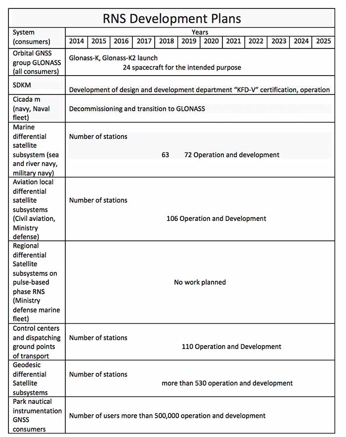
At over a hundred pages, this plan has a lot of information. It includes a table of 19 different navigation systems maintained by the government and the plan for each. This table also suffered when the document was transformed into the English version. The manual re-recreation is below:
Click to enlarge. (Source: “Radio Navigation Development Plan for Participating Commonwealth of Independent States for 2019 to 2024”)Click to enlarge. (Source: “Radio Navigation Development Plan for Participating Commonwealth of Independent States for 2019 to 2024”)
Russia has launched another GLONASS-M satellite, according to Roscosmos, the Russian State Space Corporation.
A Soyuz-2.1b launch vehicle successfully carried the satellite to its planned orbit from the Plesetsk cosmodrome. The launch took place on schedule on March 16.
Ground-based facilities of the G.S. Titov Space Forces VKS immediately took control of the satellite. A stable telemetry connection has been established and maintained with the satellite. The onboard systems of the spacecraft are operating normally.
The launch used a Fregat booster block produced by NPO Lavochkin, part of the Roscosmos State Corporation. The satellite was manufactured by ISS, also part of Roscosmos State Corporation.
The Soyuz-2.1b launch vehicle with encapsulated GLONASS-M satellite is transported to the launchpad. (Screenshot: Russian Ministry of Defense video)
For the GLONASS constellation, a full complement of 24 satellites are set healthy. In addition, four satellites previously in the constellation are classified as spares, in maintenance or in test.
The just-launched satellite is expected to replace a currently operational GLONASS-M satellite, specifically GLONASS 735 in orbital slot 24). Of the 24 healthy satellites, one is a K1; the rest are Ms. The satellite in test is also a K1 (the first K1 to be launched).
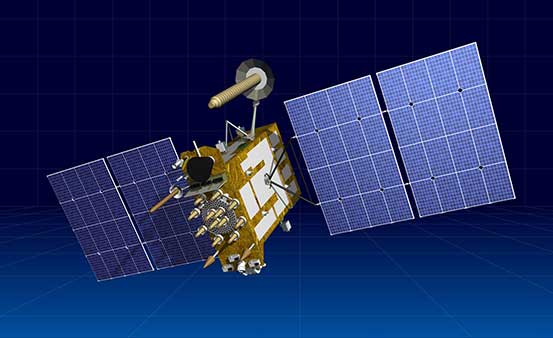
Artist’s rendering of a Glonass-K satellite. (Image: ISS-Reshetnev)
ISS-Reshetnev Company — the primary GLONASS contractor — has a backlog of orders for navigation satellites up to 2025, according to General Director Nikolay Testoyedov.
Testoyedov discussed GLONASS production on Dec. 30, 2019, at a meeting hosted by ISS-Reshetnev Company for Russia’s Science and Technical Council.
“Within the Federal Target Program, GLONASS ISS-Reshetnev Company is tasked with the production of 27 navigation satellites,” Testoyedov said. “Taking all things together, we plan to double the number of satellites launched in 2020 compared to 2019.”
The orders require production at full capacity at the company’s facilities. At any given time, about 50 satellites are in varying stages of production, including 12 ground spares. Some of them are slated for launch in 2020.
In 2019 eight satellites designed and built by the company were launched into various orbits. As of today, 104 ISS-Reshetnev-made satellites are in space, or two-thirds of Russia’s entire orbital fleet of satellites. ISS-Reshetnev also successfully completed several projects for the manufacture of satellite onboard systems and instruments, including the international ExoMars-2020 program slated to launch this year.
A joint team of experts representing ISS-Reshetnev Company and the operating organization successfully completed all procedures moving the Glonass-M satellite to its proper orbital position, and switched on its main instruments. To this date, all the required data has been received from the satellite, which allowed it to be commissioned into service.
The new Glonass-M replaced a retired satellite of the GLONASS constellation that had surpassed its designed life expectancy by seven years.


 “Some still appear to believe that the number of satellites and their orbital height offer some level of protection. They refuse to look to the ground for resilient solutions using proven and highly reliable technology — which, coincidently, both Russia and China continue to operate as their resilient PNT solutions. The United States and its allies cannot continue to be dictated to by financial analysts who resist these solutions for fear of exposing the poor decisions they supported in the past and continue to support regarding a solution with a higher power and low frequency.”