A Eutelsat communications satellite launched Oct. 9 carried a payload for the European GNSS Agency (GSA) called GEO-3. GEO-3 is a geostationary satellite designed to augment GNSS signals.
The EGNOS payload, manufactured by Airbus Defence and Space, will hone the accuracy of satellite navigation signals over Europe for use in aviation, maritime and other industries as part of the European Geostationary Navigation Overlay System (EGNOS).
The Eutelsat-5 West B satellite also hosts a payload that will enable service continuity for television broadcasting in Europe and North Africa.
The GSA signed a contract in March 2017 with Eutelsat Communications for the development, integration and operation of the next-generation GEO-3 EGNOS payload.
EGNOS operational messages are broadcast via navigation payloads on-board two GEO satellites, including an Inmarsat-3F2 satellite that is fast approaching end-of-life. The GEO-3 services replenish the EGNOS SBAS payloads, guaranteeing EGNOS availability and supporting the transition to the dual-frequency multi-constellation-capable EGNOS V3.
Eutelsat will also develop two redundant RF ground stations to uplink the EGNOS message to the payload. It will also host EGNOS’ Navigation Land Earth Stations (NLES) in Rambouillet, France, and Cagliari, Italy, both of which will be co-located and connected to the RF ground stations.
Proton-powered launch
The satellite was carried aloft on a Proton rocket along with a second satellite, the Mission Extension Vehicle-1 for Northrop Grumman subsidiary SpaceLogistics, designed to service satellites. Both spacecraft were built by Northrop Grumman.
The Proton rocket lifted off at 6:18 a.m. Eastern Time from Russia’s Baikonur Cosmodrome in Kazakhstan. Its two passengers separated from the rocket 16 hours later in a supersynchronous transfer orbit.
Eutelsat-5 West B is a replacement for the 17-year-old Eutelsat-5 West A satellite.
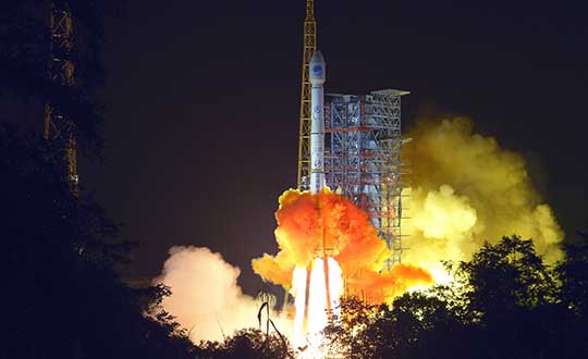
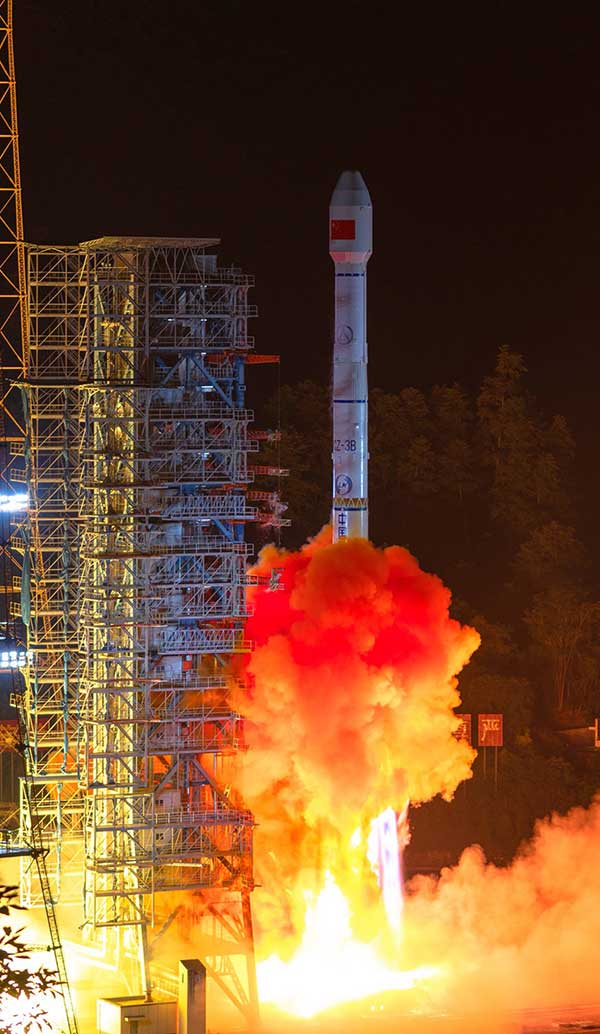
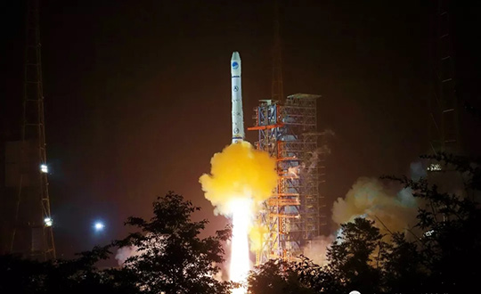
China has launched two more BeiDou III satellites. The launch took place on Sunday, Sept. 22, using a Long March 3B rocket which lifted off from the Xichang space center at 2110 GMT (5:10 p.m. EDT), according to the Xinhua News Agency.
About four hours after liftoff, the upper stage delivered the Beidou satellites into a nearly circular orbit with an average altitude of 13,500 miles (21,800 kilometers) and an inclination of 55 degrees.
The satellites were produced by the China Academy of Space Technology, a government-owned satellite builder.
With Sunday’s launch, China has added five new satellites to the Beidou network this year, halfway to its stated goal of 10 Beidou satellites this year.
The satellites are the 47th and 48th spacecraft launched in the Beidou navigation program.
GPS OCX will maneuver satellite into final orbit over 10 days
The U.S. Air Force used Raytheon Company’s GPS Next-Generation Operational Control System, known as GPS OCX, to support the launch of its second GPS III satellite into space. The ground system will now spend 10 days maneuvering the satellite into its final orbit, demonstrating GPS OCX’s ability to simultaneously support multiple GPS III spacecraft on-orbit throughout the checkout and calibration process.
Raytheon’s GPS OCX has obtained the highest level of cybersecurity protections of any Department of Defense space system.
“GPS OCX performed extremely well during the first launch and has exceeded performance requirements in the months since,” said Dave Wajsgras, president of Raytheon Intelligence, Information and Services. “The team was well-prepared for this launch, and we’re confident the system’s performance will continue to be positive.”
GPS OCX, the enhanced ground control segment of America’s GPS system, has achieved the highest level of cybersecurity protections of any Department of Defense space system. Its open architecture design allows it to integrate advanced protections as they become available, and the system’s industry-leading cyber protections are why it will be used to support all future GPS III launches and GPS constellation operations upon operational acceptance.
Earlier this year, the team completed final qualification testing of the system’s modernized monitor station receivers, which can receive and decrypt all GPS III military and civil signals. Global installation of the receivers starts next month and keeps the program on track for full system delivery by the program’s June 2021 contractual deadline.
In addition to GPS OCX’s role, RGNext, a joint venture between Raytheon and General Dynamics Information Technology, provided operational launch support to ensure the safe launch of the United Launch Alliance’s Delta-IV rocket that was carrying the GPS III satellite. RGNext operates the launch range on behalf of the U.S. Air Force, providing maintenance, range safety, weather monitoring, communication and surveillance support for all launches conducted by defense, civil and commercial companies at the range. To access our press kit, which includes photos, videos and an animation, please visit us here. To learn more about the program’s progress and additional capabilities, visit us here.
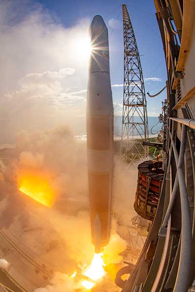
A ULA Delta IV rocket carrying GPS III SV02 lifts off from Space Launch Complex-37 on Aug. 22. (Photo: ULA)
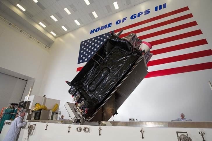
The U.S. Air Force’s second next-generation GPS III satellite, built by Lockheed Martin, is responding to commands, under control and now using its own internal propulsion system to get to orbit following its successful Aug. 22 launch.
At 11:01 a.m. ET, Air Force and Lockheed Martin engineers at Lockheed Martin’s Launch & Checkout Facility near Denver declared they had full control of GPS III Space Vehicle 02 shortly after the satellite’s separation from its United Launch Alliance (ULA) Delta IV rocket booster. The satellite, nicknamed “Magellan” by the Air Force, began its rocket ride to space with a 09:06 a.m. ET launch from Cape Canaveral Air Force Station.
GPS III SV02 is now climbing towards its operational orbit about 12,550 miles above the earth under the power of its own Liquid Apogee engines. Engineers at Lockheed Martin Space’s Waterton, Colorado facility are commanding the satellite using elements of the GPS Next Generation Operational Control System (OCX) Block 0.
“GPS III SV02 is receiving and responding to commands just as planned. In the days ahead, we’ll finish orbit raising to our operational slot and then send the satellite commands telling it to deploy its solar arrays and antennas,” said Johnathon Caldwell, Lockheed Martin Space’s Vice President for Navigation Systems. “Once we are set up, we’ll begin on-orbit checkout and tests, including extensive signals testing with our advanced navigation payload.”
The payload is provided by L3Harris. The first GPS III satellite launched in December 2018 and its navigation payload has performed beyond expectations on-orbit during pre-operational testing, according to L3Harris.
GPS III SV02 is the second GPS III satellite designed and built by Lockheed Martin to help the Air Force modernize today’s Global Positioning System (GPS) constellation with new technology and capabilities. GPS III satellites provide 3x greater accuracy and up to 8x improved anti-jamming capabilities. GPS III also provides a new L1C civil signal, compatible with other international global navigation satellite systems, like Europe’s Galileo.
The First GPS III Satellite Completes On-Orbit Testing
Image: ULA
GPS III SV02 will be the second GPS III satellite in orbit and the second GPS III satellite now being commanded from Lockheed Martin Space’s facility.
On Dec. 23, 2018, the Air Force launched the first GPS III satellite. Nicknamed “Vespucci,” GPS III SV01 underwent months of checkout and thorough testing of its advanced, new navigation payload provided by Harris Corporation.
“GPS III SV01’s performance exceeded expectations during testing,” Caldwell said. “On July 12, we officially completed all On Orbit Check Out & Test activities. We are excited to see this satellite move to the next phase and perform in an operational environment.”
That’s expected to happen later this year once the first satellite is handed over to the Air Force.
Thinking Ahead From the Ground Up
In preparation for this handover, in 2016, the Air Force awarded Lockheed Martin the GPS III Contingency Operations (COps) contract to upgrade its current GPS ground control system – the Operational Control Segment (OCS) – to be able to fly today’s 31-satellite constellation, as well as the new, more-powerful GPS III satellites, until OCX Block 1, still in development, is delivered.
Lockheed Martin delivered the GPS III COps software upgrade in May and it is currently undergoing preparations for installation.
COps is the latest GPS ground control upgrade project Lockheed Martin has had since it began sustaining the OCS in 2013. In November 2018, the company completed the AEP 7.5 upgrade — the largest architectural change in the system’s history — replacing significant code, hardware and software to improve the system’s cybersecurity capabilities and positioning the Air Force to better operate in contested, degraded and operationally limited environments.
In December 2018, the Air Force awarded Lockheed Martin the GPS Control Segment Sustainment II (GCS II) contract to continue to further modernize and sustain the OCS through 2025.
In 2020, the OCS is expected to receive the M-Code Early Use (MCEU) upgrade, which will allow control of M-Code, an advanced, new signal designed to improve anti-jamming and anti-spoofing, as well as to increase secure access to military GPS signals for U.S. and allied armed forces.
With GPS III SV01 and SV02 now on orbit, GPS III satellites continue to roll off the production line at Lockheed Martin’s advanced $128-million GPS III Processing Facility near Denver. On May 27, the Air Force declared the GPS III SV03 Available for Launch (AFL) and had the company place it into storage waiting for a launch date. GPS III SV04-08 are now in various stages of assembly and test.
In all, Lockheed Martin is under contract to build up to 32 next-generation GPS III/IIIF satellites for the Air Force. Additional IIIF capabilities will begin being added at the 11th satellite. These will include a fully digital navigation payload, a Regional Military Protection capability, an accuracy-enhancing laser retroreflector array, and a Search & Rescue payload.
The second GPS III satellite — nicknamed Magellan — is now at the launchpad at Cape Canaveral Air Force Station, Florida, in preparation for liftoff on Aug. 22.
United Launch Alliance tweeted out an image of the encapsulated satellite on its way to the rocket.
The Lockheed Martin-built satellite was originally scheduled for launch on July 25, but the launch was pushed to Aug. 22 because of “an anomaly during component testing at a supplier that created a cross-over concern. Upon further evaluation, additional time is needed to replace and retest the component on the launch vehicle,” ULA said.
Launch Updates
The launch window on Aug. 22 will open at 9 a.m. EDT (1300 UTC) and extend to 9:27 a.m. EDT (1327 UTC), a 27-minute duration. ULA’s live countdown blog begins at 11:45 p.m. EDT (0345 UTC) on Aug. 21. The launch webcast starts at 8:40 a.m. EDT (1240 UTC).
GPS III SV02 will be the 29th and final flight of the Delta IV Medium rocket, the 73rd GPS launch by a ULA or heritage vehicle and marks ULA’s 135th mission.
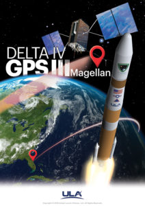
GPS III SV02 is named Magellan in honor of the Portuguese explorer who led the first expedition to circumnavigate the Earth.
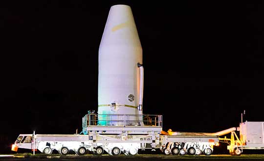
The satellite, encapsulated in the 4-meter-diameter composite payload fairing, was moved overnight last week from its processing facility to the seaside launchpad at a top speed never exceeding 5 mph.
The satellite was hauled by a motorized KAMAG Elevating Platform Transporter (EPT) that provided hydraulic leveling and precision positioning capabilities along the route. The EPT also towed a Portable Environmental Control System (PECS) trailer to supply conditioned air to the payload fairing during the trip.
Once parked in the hoistway on the backside of the Mobile Service Tower (MST), technicians used the crane system in the gantry the next morning to carefully lift the satellite onto the Delta IV rocket’s second stage to complete a successful vertical integration of the launch vehicle and payload. The fully assembled rocket now stands 207 feet tall.
A tip-to-tail electrical test of the combined payload and launch vehicle will occur next, an operation known as the Integrated Systems Test (IST). Once that is completed, the comprehensive process to verify flight readiness will begin in parallel to final vehicle closeouts for the launch targeted for Aug. 22 at 9 a.m. EDT (1300 UTC).
ULA rockets have successfully launched 70 GPS satellites since 1978.
ULA technicians transport the GPS III satellite to the Delta IV launchpad. (Photo: United Launch Alliance)The Delta IV rocket leaves the the Horizontal Integration Facility (HIF) aboard a 36-wheel, diesel-powered transporter on May 28 and traveled to Space Launch Complex-37. The trip took 40 minutes. (Photo: ULA)
The EDRS-C satellite, the second node of the SpaceDataHighway network — also known as the European Data Relay System (EDRS) — has successfully launched into geostationary orbit at 31 degrees East by an Ariane 5 rocket from Kourou, French Guiana. According to Airbus, after a test period, it will double transmission capacity of the system in order to serve two observation satellites simultaneously and provide redundant back-up for the SpaceDataHighway.
This second satellite is joining EDRS-A, which transmits the images of Earth acquired by the Copernicus program’s four Sentinel observation satellites on a daily basis.
According to Airbus, the SpaceDataHighway is the world’s first “optical fiber” network in the sky based on cutting-edge laser technology. A public-private partnership between the European Space Agency and Airbus, it is a network of geostationary satellites permanently fixed over a network of ground stations that can transmit data at a rate of 1.8 Gbit/s.
SpaceDataHighway satellites can connect to low-orbiting observation satellites at a distance up to 45000 km, intelligence UAVs or mission aircraft via laser, Airbus added. From its position in geostationary orbit, the SpaceDataHighway system relays data collected by observation satellites to Earth in near-real-time.
“The SpaceDataHighway makes our data connections more secure, more stable, more reliable, with more bandwidth and in near real time,” said Evert Dudok, head of communications, intelligence and security at Airbus Defence and Space. “The launch of our second satellite is just the start, laser communication will be a revolution for many industries.”
Full operations, including EDRS-C, are expected by the end of 2019, when its inter-satellite link and end-to-end service will be tested and commissioned with the Sentinel satellites. A third communication node is to be positioned over the Asia-Pacific region by around 2024.
In addition, from 2021, the Pleiades Neo Earth observation satellites will begin to use the SpaceDataHighway, and by the end of 2019, the system will also provide a fully European broadband communication service to the Columbus module of the International Space Station, Airbus said.
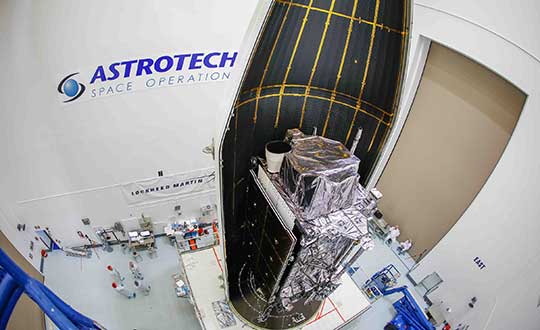
The second next-generation GPS III satellite — nicknamed “Magellan” by the U.S. Air Force — is encapsulated and ready for its planned July 25 launch.
On June 26, Lockheed Martin Space and United Launch Alliance (ULA) technicians completed encapsulating GPS III Space Vehicle 02 (GPS III SV02) in its launch fairings at the company’s Astrotech Space Operations facility, where the satellite has undergone pre-launch processing and fueling since its March 19 arrival in Florida. This final step enclosed GPS III SV02 in a protective, aerodynamic, nose-cone shell.
In the coming days, the enclosed GPS III SV02 satellite will be mounted to a ULA Delta IV rocket for launch. The current window for launch on July 25 opens at 10:55 a.m. ET.
“GPS III SV02 is launching just a brisk seven months after the nation’s first GPS III satellite lifted off back in December. The first satellite’s performance during on-orbit testing has exceeded expectations,” said Johnathon Caldwell, Lockheed Martin’s vice president for Navigation Systems. “We are excited to deploy more GPS III satellites so this new technology and capabilities can be distributed constellation-wide.”
GPS III satellite production and launch cadence is picking up. On May 27, the Air Force declared the next GPS III satellite, GPS III SV03, available for launch, pending an official launch date.
“More GPS III satellites are coming. If you looked at our production line back in Denver today you would see GPS III space vehicles 04, 05 and 06 already fully-assembled and in various stages of testing. And space vehicles 07 and 08 are being built up at the component assembly level now,” Caldwell added. “It is a smooth, efficient, methodical process.”
Lockheed Martin is under contract to develop and build up to 32 GPS III/IIIF satellites for the Air Force. GPS III will deliver three times better accuracy and provide up to eight times improved anti-jamming capabilities. GPS III’s new L1C civil signal will make it the first GPS satellite to be interoperable with other international global navigation satellite systems, like Galileo.
Additional GPS IIIF capabilities will begin being added with the 11th satellite. These will include a fully-digital navigation payload, a Regional Military Protection capability, an accuracy-enhancing laser retroreflector array, and a search-and-rescue payload.
Seven-ninths of the way there! The 21st satellite of the BeiDou-3 global constellation, destined to number 27 upon completion, successfully launched from Xichang on June 24. Once in final orbit and commissioned, it will become the second of three planned inclined geosynchronous orbit (IGSO) satellites, traipsing in figure-eight loops across the skies above China and neighbors in the Asia-Pacific region.
The IGSO trio will play a key role in the expansion of BeiDou-3 from a regional to a global system, in that they may afford the Asia-Pacific region greater BeiDou-derived accuracy and availability — the so-called “optimized coverage” — than will be accessible to users of the constellation in other areas of the world.
The new satellite, like others of its latest generation, will establish inter-satellite ranging links, and carries new-gun rubidium atomic clocks and passive hydrogen maser clocks. It weighs 450 kg, a gain over previous generations, with a phased array antenna for navigation signals, a laser retroreflector and deployable S/L-band and C-band antennas.
While BeiDou-3 has widespread applications in construction, transportation, fishing, power grid, disaster response, public security, smart cities and more, it will also bring increased capability — and independence from GPS — to the People’s Liberation Army. At 2 million strong with modernizing equipment, this is a force to be reckoned with in an increasingly unsettled region, with China actively pursuing numerous territorial disputes.
BeiDou-3 is migrating its civil or B1 signal from 1561.098 MHz to 1575.42 MHz, the same as the GPS L1 and Galileo E1, and changing from a quadrature phase shift keying modulation to a multiplexed binary offset carrier modulation similar to Galileos E1 and the pending GPS L1C.
Technicians successfully integrated the U.S. Air Force’s third GPS III space vehicle (GPS III SV03) on August 14, 2017. (Photo: Lockheed Martin)
On May 22, Lockheed Martin delivered the GPS III Contingency Operations (COps) software upgrade to the U.S. Air Force’s current GPS ground control system.
The upgrade will enable the Air Force to start commanding the new, next-generation GPS III satellites now coming off the production line and beginning to launch.
And the new GPS III satellites are coming. The first GPS III satellite launched in December 2018; the second GPS III shipped to Cape Canaveral in March for a July launch; and on May 17, the Air Force declared the third new GPS III “Available for Launch” next.
Ground System. The challenge was modernizing the current ground system — formally known as the GPS Architecture Evolution Plan Operational Control System (AEP OCS) — to fly the legacy constellation, as well as the new, modern GPS III satellites, until the next generation Operational Control System (OCX) Block 1, still in development, is delivered.
To address this, in 2016, the Air Force contracted Lockheed Martin to develop the GPS III COps program. Currently, the AEP OCS controls 31 GPS IIA, IIR, IIR-M and IIF satellites launched between 1993-2016. With the AEP OCS’ new GPS III COps upgrade, the Air Force will be able to command and control both the legacy satellites, as well the more powerful GPS III satellites.
Lockheed Martin shipped the U.S. Air Force’s first GPS III to Cape Canaveral, Florida ahead of its expected July launch. (Photo: Lockheed Martin)
“Positioning, Navigation and Timing is a critical mission for our nation and COps will allow the Air Force to gain early access to its new GPS III satellites,” said Johnathon Caldwell, Lockheed Martin’s vice president for Navigation Systems. “We just finished Final Qualification Testing and delivery on COps, and it will be integrated and installed on the AEP OCS over the summer. We look forward to the Air Force ‘flying’ a GPS constellation on the COps OCS which includes the new GPS III satellites, later this year.”
Meanwhile, the first GPS III space vehicle (GPS III SV01), launched in December 2018, is finishing up pre-operational on-orbit check-out. It continues to be controlled by OCX Block 0 software installed at Lockheed Martin’s GPS III Launch and Checkout Center at the company’s Denver facility. GPS III SV01 is expected to be “handed over” to the COps OCS later this year after the legacy constellation is moved over to the updated AEP OCS.
Lockheed Martin has sustained the AEP OCS since 2013. In November 2018, the company completed the AEP 7.5 upgrade — the largest architectural change in the systems history — replacing significant code, hardware and software to improve the system’s cybersecurity capabilities and positioning the Air Force to better operate in contested, degraded and operationally limited environments.
In December 2018, the Air Force awarded Lockheed Martin the GPS Control Segment Sustainment II (GCS II) contract to continue to further modernize and sustain the AEP OCS through 2025. In 2020, the AEP OCS is expected to receive the M-Code Early Use (MCEU) upgrade, which will allow control of M-code, an advanced, new signal designed to improve anti-jamming and anti-spoofing, as well as to increase secure access to military GPS signals for U.S. and allied armed forces.
Lockheed Martin is under contract to develop and build up to 32 GPS III/IIIF satellites. GPS III will deliver three times better accuracy and provide up to eight times improved anti-jamming capabilities. GPS III’s new L1C civil signal will make it the first GPS satellite to be interoperable with other international global navigation satellite systems. Additional “IIIF” capabilities, beginning at the 11th satellite, will include a fully digital navigation payload, Regional Military Protection, an accuracy-enhancing laser retroreflector array, and a Search & Rescue payload.
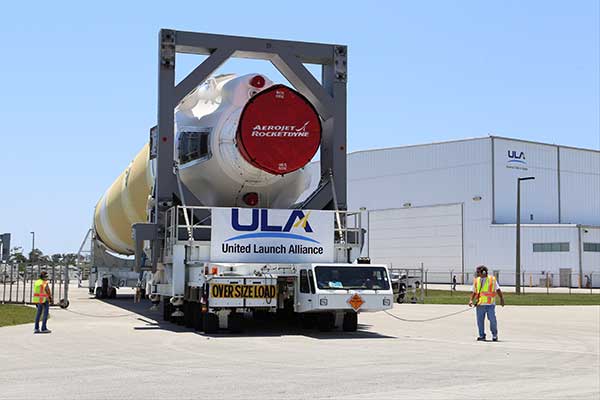
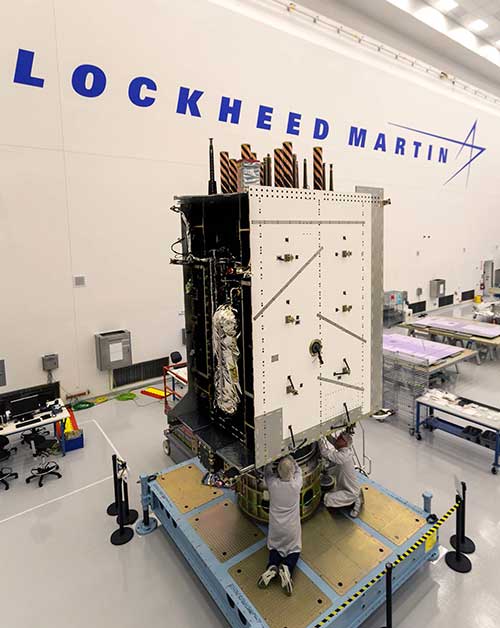
The U.S. Air Force’s second new GPS III satellite, bringing higher-power, more accurate and harder-to-jam signals to the GPS constellation, has arrived in Florida for launch.
On March 18, Lockheed Martin shipped the Air Force’s second GPS III space vehicle (GPS III SV02) to Cape Canaveral for an expected July launch.
Designed and built at Lockheed Martin’s GPS III Processing Facility near Denver, the satellite traveled from Buckley Air Force Base, Colorado, to the Cape on a massive Air Force C-17 aircraft. The Air Force nicknamed the GPS III SV02 “Magellan” after Portuguese explorer Ferdinand Magellan.
GPS III is the most powerful and resilient GPS satellite ever put on orbit. Developed with an entirely new design, for U.S. and allied forces, it will have three times greater accuracy and up to eight times improved anti-jamming capabilities over the previous GPS II satellite design block, which makes up today’s GPS constellation.
GPS III also will be the first GPS satellite to broadcast the new L1C civil signal. Shared by other international global navigation satellite systems, like Galileo, the L1C signal will improve future connectivity worldwide for commercial and civilian users.
The Air Force began modernizing the GPS constellation with new technology and capabilities with the December 23, 2018 launch of its first GPS III satellite. GPS III SV01 is now receiving and responding to commands from Lockheed Martin’s Launch and Checkout Center at the company’s Denver facility.
Lockheed Martin shipped the U.S. Air Force’s first GPS III to Cape Canaveral, Florida ahead of its expected July launch. (Photo: Lockheed Martin}
“After orbit raising and antenna deployments, we switched on GPS III SV01’s powerful signal-generating navigation payload and on Jan. 8 began broadcasting signals,” Johnathon Caldwell, Lockheed Martin’s Vice President for Navigation Systems. “Our on orbit testing continues, but the navigation payload’s capabilities have exceeded expectations and the satellite is operating completely healthy.”
GPS III SV02 is the second of ten new GPS III satellites under contract and in full production at Lockheed Martin. GPS III SV03-08 are now in various stages of assembly and test. The Air Force declared the second GPS III “Available for Launch” in August and, in November, called GPS III SV02 up for its 2019 launch.
In September 2018, the Air Force selected Lockheed Martin for the GPS III Follow On (GPS IIIF) program, an estimated $7.2 billion opportunity to build up to 22 additional GPS IIIF satellites with additional capabilities.
GPS IIIF builds off Lockheed Martin’s existing modular GPS III, which was designed to evolve with new technology and changing mission needs. On September 26, the Air Force awarded Lockheed Martin a $1.4 billion contract for support to start up the program and to contract the 11th and 12th GPS III satellite.
Once declared operational, GPS III SV01 and SV02 are expected to take their place in today’s 31 satellite strong GPS constellation, which provides positioning, navigation and timing services to more than four billion civil, commercial and military users.
Less than three weeks after its launch, the first GPS III satellite, SVN74, started transmitting navigation signals. SVN74 uses the pseudorandom noise (PRN) code number G04 previously used by the almost 25-year-old Block IIA satellite SVN36. The L1 C/A, L1 P(Y), and L2 P(Y) signals of SVN74 have been tracked since Jan. 9 at 00:01 UTC. Activation of the L2C and L5 signals followed on the same day at 19:43 UTC. Transmission of the legacy navigation message (LNAV) started Jan. 9, but the satellite is still marked unhealthy for ongoing on-orbit check out and testing.
Also, SVN74 is the first GPS satellite to transmit a new civil signal on the L1 frequency (1575.42 MHz), namely L1C, which was initially activated on the same day as the other SVN74 signals. Incidentally, the L1C signal was already being transmitted by the four satellites of the Japanese Quasi-Zenith Satellite System (QZSS).
Compared to the L1 C/A PRN codes, the L1C codes are 10 times longer (10,230 chips), reducing interference when multiple satellites are tracked by a receiver on the same frequency. Like L2C and L5, the L1C signal consists of a dataless pilot component and the data component with navigation data. Dataless signals enable more robust tracking under difficult conditions. For the L1C signal, 75 percent of its power is put into the pilot component.
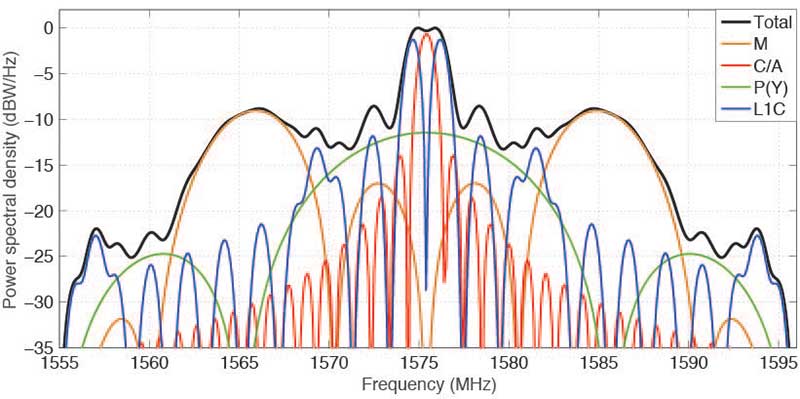
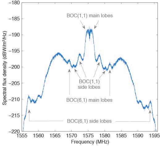
The theoretical spectra of the four signals transmitted on L1 by SVN74, namely the civil C/A-code and L1C, as well as the military P(Y)-code and M-code, are shown in FIGURE 1 along with the the total (summed) spectrum.
Figure 1. Theoretical spectra of the four signals transmitted by a GPS III satellite in the L1 frequency band. (Image: Authors)
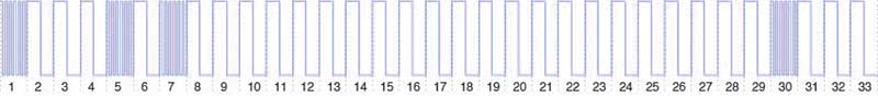
BOC. To achieve compatibility with the L1 C/A-code signal at the same center frequency, a binary offset carrier (BOC) modulation is used for spectral separation of L1C from L1 C/A. A BOC(n,m) signal is characterized by the fundamental frequency of the square wave subcarrier expressed in multiples n of the basic frequency of 1.023 MHz and the chipping rate expressed in multiples m of 1.023 megachips per second. A BOC(1,1) modulation is used for the L1C data component. For the pilot component, a time-multiplexed binary offset carrier (TMBOC) is used. The spreading waveform, with a length of 33 symbols, consists of four BOC(6,1) and 29 BOC(1,1) symbols as illustrated in FIGURE 2 resulting in a TMBOC(6,1,4/33) signal. The additional BOC(6,1) component allows for improved multipath mitigation.
Figure 2. Spreading symbols for the L1C pilot component: time-multiplexed BOC consisting of BOC(6,1) for the 1st, 5th, 7th and 30th symbols and BOC(1,1) for the other symbols. (Image: Authors)
Similar to GPS L1C, the European Galileo and the Chinese BeiDou-3 systems employ multiplexed BOC signals with BOC(1,1) and BOC(6,1) components in the L1 frequency band. A composite BOC (CBOC) modulation has been adopted for the Galileo E1 open service signal, which uses a weighted sum of the BOC(1,1) and BOC(6,1) components in both the data and the pilot channels. For the BeiDou B1C signal, BOC(1,1) is used for the data channel, while a quadrature multiplexed BOC modulation, QMBOC(6,1,4/33), with BOC(1,1) and BOC(6,1) subcarriers in phase quadrature, is used for the pilot channel.
Interoperability. The new civil L1 signals of GPS, Galileo and BeiDou show a high level of commonality and are specifically designed for full interoperability. This means that receivers can easily track signals of all three constellations and use the measurements to compute a combined multi-GNSS position solution. Aside from the similar signal modulations, the interoperability is further supported by the transmission of inter-system timing biases (such as the GPS-Galileo Time Offset) in the navigation messages.
The binary phase shift keying (BPSK) modulation of the C/A-code with a 1.023-MHz chipping rate introduces a main lobe at the center frequency of 1575.42 MHz and numerous side lobes with decreasing amplitude. The 10.23-MHz BPSK signal of the P(Y)-code is visible in Figure 1 as a broad peak at the center frequency and first side lobes at about 1560 and 1590 MHz. The M-code is characterized by its main lobes ±10.23 MHz from the center frequency due to its BOC(10,5) modulation. Finally, the L1C signal can be recognized as two narrow peaks separated by ±1.023 MHz from the L1 center frequency related to the BOC(1,1) modulation and two peaks at ±6.138 MHz related to the BOC(6,1) modulation. Side lobes of the BOC(1,1) signal are visible next to the main lobes at integer multiples of 2 × 1.023 MHz.
Observations. The German Aerospace Center (DLR) operates a 30-meter dish antenna at its ground station in Weilheim, near Munich, Germany. FIGURE 3 shows the L1 spectrum of SVN74 measured on January 15, 2019. One can clearly see the L1C BOC(1,1) main lobes at 1574 and 1576 MHz as well as the BOC(6,1) main lobes at 1569 and 1581 MHz. Selected side lobes are also indicated.
Figure 3. SVN74 L1 spectral flux density measured with the Weilheim 30-meter antenna on January 15, 2019, at 08:04 UTC. Selected features of the L1C signal are indicated by arrows. (Image: Authors)
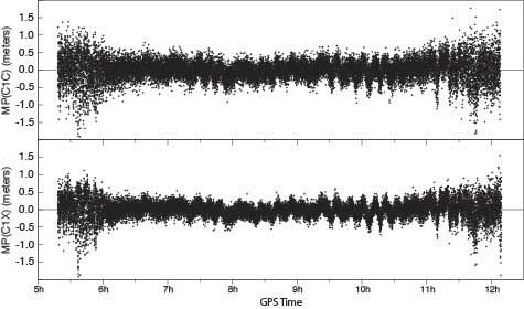
Initially, none of the International GNSS Service network receivers could track the L1C live signal of SVN74, but dedicated firmware versions supporting L1C tracking were soon made available by selected manufacturers. FIGURE 4 shows the multipath linear combination for the L1 C/A-code and the L1C signal tracked with a Javad TRE-G3TH receiver. Reduced measurement noise (multipath plus receiver measurement noise) of the L1C signal can be seen over all elevation angles ranging from about 3 to 83 degrees. (Tracking of the pass began at 4.3 degrees and ended at 3.0 degrees.)
Figure 4, Multipath linear combination (L1 pseudorange and L1 and L2 carrier phase) of the SVN74 L1 C/A-code (top) and L1C signal (bottom) from 1-Hz data of February 3, 2019, tracked with a Javad TRE-G3TH receiver at the Geodetic Observatory Wettzell. (Image: Authors)
The overall root-mean-square noise of the SVN74 pass shown in Figure 4 is 32 centimeters for the L1 C/A-code signal and 24 centimeters for L1C, that is, a reduction of 25 percent for L1C. Compared to the BPSK modulation of the legacy C/A-code signal, the increased steepness of the TMBOC correlation function offers lower measurement noise for the L1C tracking. In addition, the sensitivity to multipath is reduced.
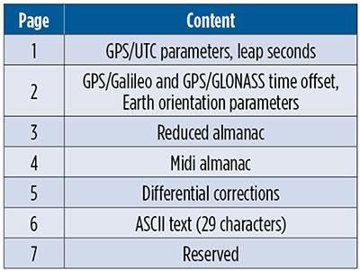
CNAV-2. Together with L1C, the second version of the civil navigation message, namely CNAV-2, is being transmitted. CNAV-2 is composed of three subframes: subframe 1 contains information about the current epoch. Subframe 2 comprises clock and ephemeris data including inter-signal corrections (ISCs). ISCs provide clock corrections for single-frequency users and dual-frequency users utilizing signals other than L1 P(Y) and L2 P(Y). Whereas the essential broadcast ephemeris data in subframe 2 repeat continuously over the validity period of typically two hours, subframe 3 contains pages with alternating content as listed in TABLE 1 (page 41).
Table 1 Currently defined pages of the CNAV-2 subframe 3.
Despite a different message layout, most CNAV-2 parameters and their values match those transmitted in the CNAV message of the L2C and L5 signals. Additional parameters comprise the ISCs for the L1C signal. Compared to the LNAV legacy navigation message, CNAV and CNAV-2 utilize an extended set of ephemeris parameters that allow for a smoother orbit representation compared to LNAV. Multi-GNSS applications benefit from the GPS/GNSS time offset (GGTO) parameters included in page 2. In the same page, Earth orientation parameters are provided that are relevant for users of an inertial frame, such as for spaceborne navigation. The CNAV-2 repeat cycle of 18 seconds allows for a faster access to broadcast ephemerides included in subframe 2 compared to LNAV. Compared to CNAV, CNAV-2 furthermore provides a more sophisticated error detection and correction scheme.
As of the beginning of February 2019, only pages 1, 2 and 4 of CNAV-2 subframe 3 are being used. Within a cycle of 144 seconds, page 1, page 2 and six sets of page 4 midi almanac data (each for one individual satellite) are transmitted. The full almanac for 32 satellites is thus transferred in an average of about 13 minutes. The content in these subframes corresponds to that in L2 and L5 CNAV messages. Updates of CNAV-2 are performed in two-hour intervals starting at 01:30. This is the same update scheme as for CNAV but different from LNAV where the two-hour intervals start at 00:00.
Note that some time will pass before enough GPS III satellites are transmitting so that users can fully enjoy the benefits of the new L1C signal.
MANUFACTURERS
Spectral measurements at the Weilheim 30-meter antenna were made with a Rohde & Schwarz FSQ26 vector signal analyzer. Receiver measurements have been collected with a JAVAD GNSS TRE-G3TH receiver running an L1C-capable firmware version.
PETER STEIGENBERGER and OLIVER MONTENBRUCK are scientists at the German Space Operations Center of the German Aerospace Center (DLR). STEFFEN THOELERT is an electrical engineer at DLR’s Institute of Communications and Navigation. RICHARD B. LANGLEY is a professor at the University of New Brunswick and editor of the Innovation column for GPS World magazine.
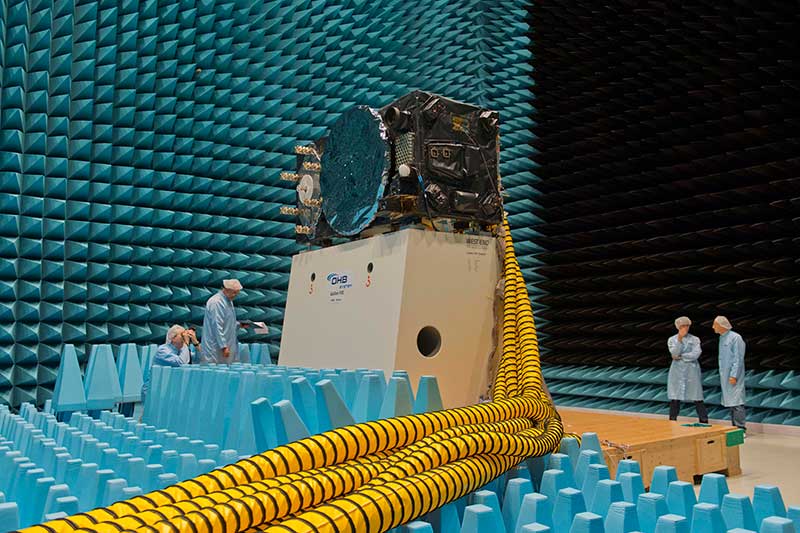
Inside the ESTEC Test Center, Galileo’s First Operational Capability first flight model, FM1, prepares for passive intermodulation testing in the Maxwell electromagnetic facility. (Photo: ESA-Anneke Le Floc’h)
Gazing through soaring plexiglass walls at the space simulation room of the European Space Agency’s Test Center in the Netherlands affords a glimpse into scientific history.
I felt a frisson, a highly regimented frisson if you will, of vicarious thrill for the rigors, rhythms and methods of research and testing as I toured the center after giving a keynote at the agency’s Navigation Days. Here, the final birthing touches were administered to transmitters beaming forth the Second Golden Age of satellite-based navigation.
One can debate which constellation combination will prove most fruitful to users: GPS plus GLONASS, GPS plus BeiDou, GPS plus Galileo (note the common term). I believe it will be the last, because of the close synergy and symbiosis of the two commercial arenas, North America and Europe.
All Galileo Full Operational Capability (FOC) satellites had their mettle and metals probed, radiated, bombarded, shaken and shocked here before they journeyed to space. The test center’s role is to verify, intensively and for months per satellite, that it can perform well for the whole of its planned lifetime.
A mass property test checks that the center of gravity and mass are aligned within design specifications, so that the satellite’s orientation can be accurately and economically controlled with thruster firings in orbit, prolonging work life by conserving propellant.
A five-week thermal-vacuum test runs inside a 4.5-meter diameter stainless steel vacuum chamber, the Phenix. An inner thermal tent heats to simulate solar radiation and cools with liquid nitrogen to create the chill of sunless space.
In the Maxwell test chamber, spiky radio-absorbent anechoic walls test electromagnetic compatibility to ensure that all systems operate together without interference. Noise horns generate more than 140 decibels to simulate a violent launch. A quad shaker table vibrates the satellite up, sideways and down, as accelerometers search for hazardous internal vibration, gathering data across hundreds of channels.
Altogether a severe trial, a crucible from which the FOC satellites emerge certified and ready for space.
Oh, that we humans were similarly tested before placement in positions of power.