China successfully launched a new pair of BeiDou navigation satellites on Sunday, Nov. 5, reports NASAspaceflight.com.
Beidou-3M1 (Beidou-24) and Beidou-3M2 (Beidou-25) went aloft aboard a Long March-3B/YZ-1 rocket at around 11:45 UTC from the LC2 Launch Complex of the Xichang Satellite Launch Center, Sichuan province.
The launch, previously scheduled for July, was delayed until now due to a partial launch failure with the previous launch of this rocket during the Zhongxing-9A (ChinaSat-9A) mission, which resulted in the satellite being lofted to a lower than planned orbit.
The satellites are using a new bus that features a phased array antenna for navigation signals and a laser retroreflector.
The Beidou Phase III system includes the migration of its civil Beidou 1 or B1 signal from 1561.098 MHz to a frequency centered at 1575.42 MHz — the same as the GPS L1 and Galileo E1 civil signals — and its transformation from a quadrature phase shift keying (QPSK) modulation to a multiplexed binary offset carrier (MBOC) modulation similar to the future GPS L1C and Galileo’s E1.
Two more Galileo satellites have reached Europe’s Spaceport in French Guiana, joining the first pair of navigation satellites and the Ariane 5 rocket due to haul the quartet to orbit this December.
Inside the 747. (Photo: ESA)
Galileos 21 and 22 left Luxembourg Airport on a Boeing 747 cargo jet on the morning of Oct. 17, arriving at Cayenne-Félix Eboué Airport in French Guiana on the same day.
Resting within distinctive white air-conditioned containers, the satellites were driven to the cleanroom environment of the preparation building within the space centre.
Waiting for them there were Galileos 19 and 20, which arrived in September.
The four satellites will be launched together in mid-December by a customised Ariane 5, the elements of which reached French Guiana last month by sea.
Galileos 21 and 22 being unloaded from their 747 cargo aircraft at Cayenne – Félix Eboué Airport in French Guiana on Oct. 17. (Photo: ESA)
Galileo is Europe’s own satellite navigation system, providing an array of positioning, navigation and timing services to Europe and the world.
A further eight Galileo Batch 3 satellites were ordered last June, to supplement the 26 built so far.
With 18 satellites now in orbit, Galileo began initial services on Dec. 15, 2016, the first step towards full operations.
Further launches will continue to build the constellation, which will gradually improve performance and availability worldwide.
Europe’s next two Galileo navigation satellites have touched down in Europe’s Spaceport in French Guiana ahead of the launch of a quartet by Ariane 5 at the end of this year (scheduled for Dec. 12).
Galileos 19 and 20 left Luxembourg Airport on a Boeing 747 cargo jet on the morning of Sept. 18, arriving at Cayenne — Félix Eboué Airport in French Guiana that evening.
Safely cocooned within protective air-conditioned containers, the pair were offloaded and driven to the cleanroom environment of the preparation building within the space centre.
A Galileo satellite in its protective container is unloaded from its cargo plane after landing in French Guiana Sept. 18. (Photo: ESA)
This building will remain their home as preparations for their launch proceeds, with the next two Galileos due to join them later this month.
The satellites join the first elements of their customised Ariane 5 at the centre — including its cryogenic main stage and half-shell payload fairing — which were delivered by ship the week before.
Galileo is Europe’s own satellite navigation system, providing an array of positioning, navigation and timing services to Europe and the world.
A further eight Galileo “Batch 3” satellites were ordered last June, to supplement the 26 built so far.
A Galileo satellite is driven to the Guiana Space Centre following its arrival on Sept. 18. (Photo: ESA)
With 18 satellites now in orbit, Galileo began initial services on Dec. 15, 2016, the first step towards full operations.
Further launches will continue to build the constellation, which will gradually improve performance and availability worldwide.
Arianespace will launch four new satellites for the Galileo constellation, using two Ariane 62 versions of the next-generation Ariane 6 rocket from the Guiana Space Center in French Guiana.
The Ariane 62 rocket. (Image: Arianespace)
The contract will be conducted by the European Space Agency (ESA) on behalf of the European Commission (DG Growth) and the European Union.
This is the first ESA first contract to use the company’s new rocket.
Stéphane Israël, Arianespace chief executive officer, and Paul Verhoef, director of Navigation at the European Space Agency (ESA), signed the launch contract for four new satellites to join the European satellite navigation system Galileo. The contract will be conducted by ESA on behalf of the European Commission (DG Growth).
These launches are planned between the end of 2020 and mid-2021, using two Ariane 62 launchers — the configuration of Europe’s new-generation launch vehicle that is best suited for the targeted orbit. The contract also provides for the possibility of using the Soyuz launch vehicle from the Guiana Space Center, if needed.
Both missions will carry a pair of Galileo spacecraft to continue the constellation deployment for Europe’s satellite-based navigation system. The satellites, each weighing approximately 750 kg, will be placed in medium earth orbit (MEO) at an altitude of 23,222 kilometers and be part of the Galileo satellite navigation constellation.
An ESA video about Ariane 6 is below:
Galileo is the first joint infrastructure financed by the European Union, which also will be the owner. The Galileo system incorporates innovative technologies developed in Europe for the greater benefit of citizens worldwide.
A total of 18 Galileo satellites already are in orbit. Fourteen of these satellites were launched two at a time by Soyuz launchers, with the last four orbited on a single Ariane 5 ES mission in November 2016. Two more Ariane 5 ES missions are planned on December 12, 2017 and in the summer of 2018.
Following the signing of this latest contract, Stéphane Israël, CEO of Arianespace, issued this statement:
“Arianespace is especially proud to have won this first launch contract for the Ariane 6 from its loyal customers and partners, the European Commission (DG Growth) and ESA. We are very pleased to have earned this expression of trust from the European Commission; by choosing to continue the deployment of the Galileo constellation with two Ariane 62 launches, they become the first confirmed customer for our next-generation heavy launcher, which is slated to make its initial flight in the summer of 2020. Through this decision, which adds two additional launches to follow the already-scheduled Ariane 5 ES flights, the European Commission and ESA are clearly indicating a key commitment to Arianespace’s next generation of launchers, which reaffirms more than ever its mission to ensure Europe’s autonomous access to space.”
The second satellite of Japan’s Quasi-Zenith Satellite System (QZSS) has started transmitting navigation signals. QZS-2, or Michibiki-2, was launched on June 1, 2017, and joins its predecessor QZS-1 (Michibiki-1), which has been in orbit since September 2010.
Both satellites have been placed into inclined geosynchronous, elliptical orbits, which enable extended satellite visibility periods over Japan and are characteristic features for this regional navigation system.
The third satellite QZS-3 was launched on Aug. 19, 2017, into a geostationary orbit. If all goes according to plan, a fourth satellite in an eccentric orbit will follow by the end of this year and complete the constellation.
Three of six new Lockheed Martin-developed receivers are now deployed at U.S. Air Force monitoring stations to maintain the accuracy of GPS satellite signals.
In June, the first Monitor Station Technology Improvement Capability (MSTIC) receiver became operational at Cape Canaveral Air Force Station, Florida. Upgrades continued at USAF monitoring stations at Kwajalein Atoll and Hawaii. These upgrades from early 1990s technology are part of an overall effort to modernize the current GPS ground control system, known as the Architecture Evolution Plan Operational Control Segment.
MSTIC software-defined radio technology replaces legacy receivers’ hardware-based application-specific integrated circuit platform. MSTIC leverages commercial off-the-shelf hardware without the need for custom firmware. Standard interfaces and architecture configurability simplify sustainment and enable MSTIC software to migrate to new hardware platforms as commercial vendors increase processing power, improve reliability and enhance cybersecurity. MSTIC enables remote application of mission-specific software updates to improve performance and enable reception of modernized GPS signals, according to the company.
The three remaining GPS Monitoring Stations will be upgraded with MSTIC receivers by the end of 2017.
The navigation payload before integration into the second GPS III SV, which now is in environmental testing. (Photo: Harris)
GPS III Payloads Delivered
Harris Corporation has delivered the third of 10 advanced navigation payloads to Lockheed Martin. The payloads will increase accuracy, signal power and jamming resistance for GPS III satellites. They feature a Mission Data Unit (MDU) with a 70-percent digital design that links atomic clocks, radiation-hardened computers and powerful transmitters, enabling signals three times more accurate than those on current GPS satellites. The new payloads also boost satellite signal power, increase jamming resistance by eight times and help extend the satellite’s lifespan.
The payload was integrated into GPS III SV03 over the summer. The first navigation payload is integrated aboard GPS III SV01, which is in storage awaiting expected 2018 launch.
Harris announced it is in full production and on target to deliver the fourth GPS III navigation payload to Lockheed Martin in fall. Harris is also developing a fully digital MDU for the U.S. Air Force’s GPS III Space Vehicles 11+ acquisition. The new MDU will be demonstrated in fall 2017 and provides even greater flexibility, affordability and accuracy versus existing GPS satellites.
Next GLONASS-M Readied
The Russian navigation satellite GLONASS-M 52 moved from ISS-Reshetnev Company’s assembly plant to the Plesetsk Cosmodrome launch site about 800 km north of Moscow in August. One of the system’s ground spares, it was built more than two years ago and stored awaiting launch. The satellite is due to launch in September.
There are six GLONASS-M satellites in ground reserve.
Space Systems Loral (SSL), a provider of satellites and spacecraft systems, built the six high-resolution small satellites for Planet for its SkySat Earth observation constellation — a fleet Planet gained through the acquisition of the Terra Bella business from Google in April 2017.
Six SSL-built small satellites for Planet’s Earth observation constellation have arrived at Vandenberg AFB for launch. (Photo: SSL)
The satellites will double Planet’s high-resolution imaging capabilities and help provide information about the physical world.
The satellites, called SkySat 8 through 13, are each about 60 x 60 x 95 centimeters, weigh about 100 kilograms, and capture sub-meter color imagery and up to 90-second clips of HD video with 30 frames per second.
“Small satellites and Earth observation satellites are a growing focus for SSL,” said Dario Zamarian, group president of SSL. “SSL is known for working very collaboratively with our customers and it has been a great pleasure for our team to work together with Planet. For these satellites we have taken a fresh approach to manufacturing, learning from our GEO experience but also looking for new and more efficient processes that in turn also inform our large satellite manufacturing.”
Working together with the seven SkySats already on orbit, the new satellites will dramatically increase Planet’s high-resolution imaging capabilities, enabling multiple imaging passes in a single day. These capabilities, combined with Planet’s more than 170 Dove satellites and their advanced software analytics platform, make it possible to derive timely insights from any location in the world.
The Planet constellation provides a broad range of data, tools, and analytical services that help leaders in business and humanitarian sectors solve complex problems.
“These SkySats double the amount of high-resolution data that we can capture and serve to users, and will power insights, inform smart decisions, and most importantly, help make the world a better and safer place,” said Will Marshall, co-founder and chief executive Sofficer of Planet. “The highly experienced team at SSL has been helpful and responsive as we work together to get the satellites prepared for launch.”
SSL has deep experience in building and integrating some of the world’s most powerful and comprehensive solutions for services such as communications, Earth observation, in-orbit servicing, space robotics, and exploration.
Four SkySats built by SSL were launched in September 2016, and SSL is currently building an additional eight LEOs for Planet in its SmallSat manufacturing facility in Palo Alto, California, where the company takes an innovative approach to satellite design, assembly and test.
The Aug. 31 launch of a new Indian Regional Navigation Satellite System (IRNSS) satellite failed when the protective fairing did not separate.
Indian Space Research Organisation (ISRO) chairman AS Kiran Kumar confirmed that the mission to launch India’s eighth navigation satellite, IRNSS-1H, from the second launch pad at the spaceport of Satish Dhawan Space Centre, Sriharikota, was unsuccessful.
The 1425-kg satellite was expected to expand the existing seven satellites of the NavIC constellation. The launch vehicle PSLV-C39 lifted the satellite on Aug. 31 using the XL variant, of PSLV equipped with six strap-ons, each carrying 12 tons of propellant.
The three phases of the launch went smoothly, but unfortunately, the heat shield which was supposed to be separated in the fourth stage could not be detached.
IRNSS-1H was planned as a replacement satellite for IRNSS-1A.
The second set of 10 Iridium NEXT satellites, launched June 25 by SpaceX, are functioning nominally and have begun the testing and validation process.
The batch of 10 satellites was launched from Vandenberg Air Force Base in California, increasing the total number of Iridium NEXT satellites in space to 20.
“We are thrilled with yesterday’s success,” said Scott Smith, chief operating officer at Iridium. “These new satellites are functioning well, and we are pressing forward with the testing process.”
“Since the last launch, the team at our Satellite Network Operations Center has been anxiously awaiting this new batch of satellites. There is a lot of work to do, and we are up for the challenge,” he said.
Now, and for approximately the next 45 days, the newly launched satellites will undergo a series of testing and validation procedures, ensuring they are ready for integration with the operational constellation.
Once testing is completed, Iridium will also hand over control of Aireon’s Automatic Dependent Surveillance-Broadcast hosted payload, to the team at Aireon’s Hosted Payload Operations Center, in Leesburg, Virginia.
Mitsubishi Heavy Industries Ltd. and the Japan Aerospace Exploration Agency (JAXA) successfully launched a second navigation satellite on June 1.
The H-IIA Launch Vehicle No. 34 (H-IIA F34) delivered into orbit Michibiki No. 2 of the Quasi-Zenith Satellite System (QZSS) at 9:17:46 a.m. (JST) from JAXA’s Tanegashima Space Center.
The launch and flight of the rocket proceeded as planned, and the separation of the satellite was confirmed 28 minutes and 21 seconds after the launch time.
Michibiki 2 will be launched aboard H-IIA Launch Vehicle No. 34 from Mitsubishi Heavy Industries Ltd., according to the Japan Aerospace Exploration Agency (JAXA). Launch time is tentatively set for 9:20 a.m. (Japan Standard Time) from Yoshinobu Launch Complex, JAXA’s Tanegashima Space Center. The exact date and time could vary, with a launch window planned for June 1-30.
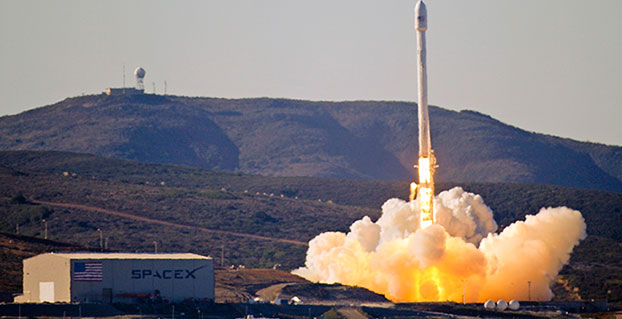
A SpaceX Falcon 9 stands ready for launch from Cape Canaveral Air Force Station, Fla. The Air Force awarded a second contract for GPS III Launch Services to SpaceX.
SpaceX has won a second contract from the U.S. Air Force for launch services to deliver a GPS III satellite to its intended orbit.
SpaceX was awarded the $96,500,490 firm-fixed-price contract over the United Launch Alliance. ULA — a joint venture of Lockheed Martin Space Systems and Boeing Defense, Space & Security — did not compete for the first GPS III launch contract. That contract, worth $82.7 million, is expected to orbit a GPS satellite aboard a Falcon 9 rocket in May 2018.
According to the contract announcement, SpaceX will provide launch vehicle production, mission integration, launch operations, spaceflight worthiness and mission unique activities for a GPS III mission. The contract is being overseen by the Air Force’s Space and Missile Systems Center (SMC), Los Angeles Air Force Base, California.
Work will be performed at Hawthorne, California; Cape Canaveral Air Force Station, Florida; and McGregor, Texas. It is expected to be complete by April 30, 2019.
“The competitive award of the GPS III Launch Services contract to SpaceX directly supports SMC’s mission of delivering resilient and affordable space capabilities to our nation,” said Lt. Gen. Samuel Greaves, leader of SMC.
The Sentinel-2B satellite was launched for the European Commission on Monday, March 6, at 10:49 p.m. local time from the Guiana Space Center (CSG), Europe’s Spaceport in Kourou, French Guiana.
Following the successful launches of Sentinel-1A, Sentinel-2A and Sentinel-1B, the mission with Sentinel-2B marks the fourth satellite in the European Commission’s Copernicus Earth observation program to be orbited by Arianespace from the Guiana Space Center, within the scope of a contract with the European Space Agency (ESA).
The Sentinel-2B Earth observation satellite mainly focuses on monitoring land masses and coastal zones around the world. It will be positioned in an orbit opposite that of Sentinel-2A to ensure optimum coverage and data delivery. The pair of Sentinel-2 satellites will cover the Earth’s entire surface in five days. This high frequency means they will capture brand-new views of the Earth, driving considerable progress in monitoring and predicting changes in vegetation and aquatic pollution.
Sentinel-2B combines a multispectral, wide-swath, very-high-resolution optical imaging instrument with a dedicated platform developed by Airbus, a long-standing partner to Arianespace. It is the 61st Earth observation satellite to be launched by Arianespace.
ESA’s Sentinel program includes six families of satellites:
Sentinel-1 will ensure data continuity with the ERS and Envisat radar satellites.
Sentinel-2 and Sentinel-3 are designed to help provide a better understanding of how climate change impacts our daily lives.
Sentinel-4 and Sentinel-5 are dedicated to meteorology and climatology, with a special focus on studying the composition of the Earth’s atmosphere.
Sentinel-6 will measure ocean topography, mainly for operational oceanography and climatology.
This was the third launch of the year for Arianespace and the first in 2017 with the Vega light launcher. It also marked the ninth successful launch in a row for Vega, which made its debut at the Guiana Space Center in 2012.