GreenRoad has announced the integration and availability of GreenRoad Advanced Tracking, powered by GPS Insight fleet tracking service. GreenRoad Advanced Tracking provides fleet operators with a new level of insight into fleet performance, resulting in improved fuel economy, better asset utilization, and enhanced productivity, GreenRoad said.
With the availability of GreenRoad Advanced Tracking, GreenRoad adds powerful fleet management capabilities to its best-in-class driver performance and safety solution, which combines real-time, in-vehicle safety feedback with a management portal that provides insight and guidance.
“GreenRoad Advanced Tracking builds on the GreenRoad Connected Fleet vision by giving managers deeper, broader insight into how they’re using their fleet assets, in addition to how their drivers are performing,” said Karen White, senior vice president of customer solutions for GreenRoad.
Additional highlights of GreenRoad Advanced Tracking include:
Interactive displays of entire fleet, any vehicle group or single vehicle. Color-coding for easy status identification, 2D and 3D mapping, vehicle history trails, automatic alerts when management attention needed.
Increased fleet activity insight with landmark and geofence support. Automatic alerts when a vehicle enters or leaves a landmark or group of landmarks.
Enhanced reporting to optimize fleet resources. Multiple, detailed activity reports including Drive Time Summary, Fleet Utilization and Odd-Hours Violations. Vehicle MPG reports available with fuel card transaction data integration.
A customizable dashboard runs specific reports and provides managerial insights with a minimum of mouse clicks.
The TraceME micro by KCS BV is a small GPS / GPRS tracker that fits inside a key chain. It is targeted for personal use and any application that need a minimum size while maintaining the exact same options and server connection full-size units have. KCS TraceME GPS / GPRS modules enable remote tracking of objects such as cars, trucks, containers, and motorcycles.
Equipped with a 65-channel Skytraq Venus634LPx GPS receiver, the KCS TraceME Module provides reliable and accurate navigational data. All communication is handled rapidly and effectively by a GPRS/GSM modem (quad-band) through GPRS or SMS. In areas without network coverage, position data and events are stored in memory (up to 55,000 positions). As soon as communication is restored, all information can be transmitted. The user-configuration menu controls actions such as sending position information, depending on all possible events. All of the necessary server-side scripts to process and store data from the TraceME units are available free of charge.
Trimble has launched a new mobile mapping product for hunters and anglers. The launch includes two smartphone apps (Trimble GPS Hunt and Trimble GPS Fish), one tablet app (Trimble GPS Maps), and a new Website — GPSHuntFish.com.
The offerings combine the latest in mobile GPS technology and Trimble’s exclusive outdoor maps to help sportsmen plan trips, navigate in remote areas, record GPS information, and privately share details with friends.
“We are excited to launch a comprehensive solution for hunters and anglers,” said Rich Rudow, general manager at Trimble Outdoors. “Now hunters can scout a future hunt at GPSHuntFish.com then send maps and GPS details to their iPhone, Android, or iPad to use in the field. In addition, they can print custom waterproof maps that compliment the digital maps displayed in the mobile apps.”
The launch includes:
Trimble GPS Hunt App
Runs on: iPhone and Android phones
Find hunting spots on detailed outdoor maps, navigate in remote areas and track wildlife. The Trimble GPS Hunt app uses the GPS built into smartphones to track position in the field—even in areas without a cell or data connection. In addition, users can mark waypoints, record tracks, view weather forecasts, see sun and moon phases, and view compass and trip details.
Trimble GPS Fish App
Runs on: iPhone and Android phones
Use Trimble GPS Fish to record fishing trips and keep a report of daily catches. Pinpoint the exact location of each catch, take photos, record GPS tracks, and view detailed street, topo and terrain maps. Use the app to return to previous fishing hotspots. In addition, with an Elite membership, users have access to more than 6,900 lake maps showing 10-foot lake depth contours.
Trimble GPS Maps App
Runs on: iPad
Plan and organize your next hunting trip or fishing trip with the Trimble GPS Maps app. Research hunting lands, find fishing spots and scout access roads on your iPad. This app allows users to fade between street, aerial and topographic maps, and instantly copy-and-paste GPS coordinates onto the digital maps.
GPSHuntFish.com is a portal for all of the Trimble hunting and fishing apps. In addition, users can view and store their trips, view maps in large format, and print maps at home or as a custom print by MyTopo.com. All trips created in the Trimble fishing and hunting apps are stored in the Trip Cloud, an online service that auto-syncs trips between a computer, smartphone and tablet device.
Trimble Elite
Works with Trimble GPS Fish, Trimble GPS Hunt, Trimble GPS Maps, GPSHuntFish.com
Trimble Elite members have access to public land boundaries for 46 states, lake maps for 6,900 lakes, forest road overlays for 134 national forests, real-time weather maps, online trip planning tools and discounts off printed maps. In addition, users can pick from a library of 3,000 Mega Offline Map bundles. These topo map bundles can be downloaded by state, county, or hunt unit and be accessed on the mobile device in remote areas, even with no cell or data connection.
How to Buy. Trimble GPS Hunt and Trimble GPS Fish are available in the Apple App Store and Google Play store. Trimble GPS Maps are available in the Apple App Store. Each app comes in a free or pro version for $4.99. The Elite membership is available for purchase in all the apps and at GPSHuntFish.com for $29.99/year or $2.99/monthly.
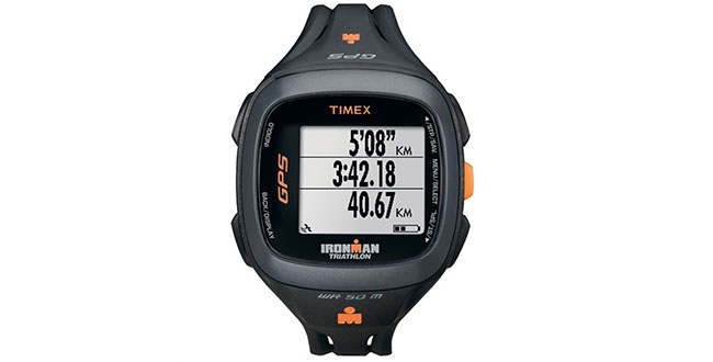
Timex has introduced the Timex IRONMAN Run Trainer 2.0, a next-generation GPS-enabled watch that tracks pace, distance, heart rate, and elapsed time. This upgraded device is a smaller, more refined version of the brand’s signature Timex IRONMAN Run Trainer 1.0 GPS watch and is equipped with a reversible, high-resolution display and advanced interval training capabilities.
The introduction of the Timex IRONMAN Run Trainer 2.0 marks a further expansion of the Timex GPS portfolio, following the recent launches of Timex Marathon GPS, Timex IRONMAN Run Trainer 1.0, Timex Cycle Trainer 2.0 and Timex IRONMAN Global Trainer Bodylink System.
“We heard from the running community that they wanted a smaller, more comfortable GPS watch,” said Sam Martin, Senior Brand Manager, Sports. “We are excited to deliver on that need with the upgraded Run Trainer 2.0, enabling more efficient training through advanced technology.”
The Timex IRONMAN Run Trainer 2.0 is designed for athletes who want to maximize the efficiency of their training. The watch offers a crisp, high-resolution display, but is smaller than the Run Trainer 1.0 to better fit a wider variety of wrist sizes. Armed with a chronograph and featuring hands-free split recording capability, the Run Trainer 2.0 includes Interval Training based on distance and time with vibrating and audible alerts. It has an eight-hour Li-ion battery life and is water resistant up to 50 meters.
Like other Timex downloadable products, this Run Trainer 2.0 is customizable through a computer device agent for all settings and is compatible with TrainingPeaks and MapMyFitness.com, among others. It utilizes ANT+ wireless technology for chest and foot pod sensors to provide heart rate and indoor/cadence-based training data for runners looking to improve their performance.
The Timex IRONMAN Run Trainer 2.0 will be available later this month in U.S. sports specialty retailers and on Timex.com at $224.95 for Speed + Distance or $274.95 (with Flex Tech Digital 2.4 HRM chest sensor).
CSR plc today announced that its SiRFstarV, SiRFprima and SiRFatlas location platforms are now able to acquire and track satellites and utilize location data from the recently activated BeiDou Satellite Navigation System.
The addition of the BeiDou constellation is part of CSR’s ongoing efforts to support all global navigation satellite systems as they become available, with software or firmware upgrades, for greater performance and enhanced compliance with existing and future requirements of national GNSS systems, the company said.
“CSR is committed to supporting all current and future GNSS constellations with its location platforms to boost location performance by increasing service availability, reducing observation time and making measurements more precise for the most demanding applications,” said Dave Huntingford, director of marketing for location at CSR. “With the addition of these new satellites, our location platforms can now actively utilize GPS, GLONASS, QZSS and SBAS, in addition to BeiDou-2, and they are ready to support Galileo as soon as it becomes available to provide continuous location awareness and the best location-based services experience.”
Rob Yeh, director of product marketing for Automotive SoC at CSR, added, “All CSR’s latest multi-GNSS location platforms, including CSR SiRFatlasVI and SiRFprimaII, are now able to demonstrate live BDS (BeiDou System) navigation, and CSR will include BDS support in all future-generation location platforms. Besides providing flexibility and improved satellite acquisition and location tracking in challenging situations like urban canyons, the BeiDou support also improves CSR’s already industry-leading dead-reckoning technologies.”
CSR maintains an experienced development team in mainland China to develop and support BeiDou-related products and technology.
Also known as Compass and BeiDou-2, the Chinese BDS started operations in December 2012 and has 14 active satellites in service over the Asia-Pacific region available to general users. When fully deployed by 2020, BDS is expected to comprise a total of 35 satellites offering complete coverage around the globe.
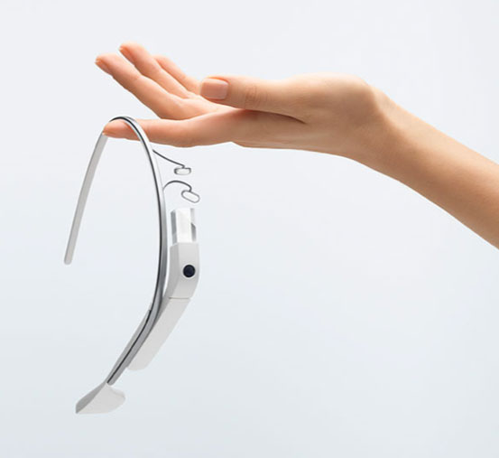
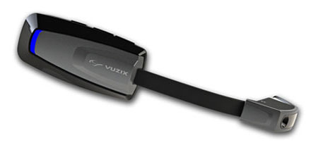
Vuzix Corporation today announced that it has begun shipping M100 Smart Glasses to the first of its Gold developer partners — enabling them to start creating and testing their apps on the real hardware.
The M100 Smart Glasses are a smart hands-free display and communications device for mobile data access, once paired to a smartphone and connected to the Internet. The glasses include an integrated head tracker and GPS for spatial and positional awareness.
Vuzix is a supplier of Video Eyewear products in the consumer, commercial and entertainment markets.
Google Glass
The M100 is in competition — and a race to market — with Google Glass, a similar wearable device. Google recently held a contest to provide sample sets of the glasses to non-developers willing to pay $1,500 — which encouraged Internet and media buzz.
M100 Smart Glasses
Google Glass could be released to the mass market by the end of the year. Google Inc. already sold an unspecified number of the glasses to developers who also paid $1,500 apiece at a company conference in June 2012. The mass-market version of Google Glass is expected to cost less than $1,500, but more than a smartphone.
Like the M100, Google Glass is intended to perform many of the same tasks as smartphones. The glasses include a little display screen attached to a rim above the right eye, run on Google’s Android operating system, and respond to voice commands, which is intended to make it easier for people to take pictures or record video wherever they might be (such as skydiving or riding a rollercoaster). Here is a video showing the glasses in action:
When he demonstrated the glasses at last June’s company conference, Google co-founder Sergey Brin acknowledged the company was still working out bugs and trying to figure out how to extend the product’s battery life.
Privacy Concerns. The ease of taking pictures and recording video with the glasses is causing some to question whether privacy will be affected. zdnet blogger Ben Woods writes, “These glasses can instantly capture and store every move of everyone around the person wearing them. Remember that drunken argument you had with your partner? Well, now Google Glass will mean you have no possibility of forgetting it. If it’s entertaining enough, or you’re well-known enough, the video of that argument could well be on YouTube before you get home. Do you do a lot of business on the phone while out and about or while sitting in coffee shops? Will you continue to, if you know that every call could be recorded by the stranger sitting at the table opposite, staring innocently at the picture on the wall behind your head?”
Google first began developing the glasses in 2010 as part of a secretive company division now known as Google X.
How the M100 is worn.
Vuzix Showstopper. Displayed at Mobile World Congress in February as a “Showstopper,” the M100 contains a near-eye micro display with an integrated camera and powerful processor running an Android OS. It connects wirelessly to a user’s smartphone (iOS or Android) or other compatible device via Bluetooth or Wi-Fi, can connect directly to the Internet, and run applications and games on its own. Working in harmony with a user’s smartphone, the M100 enables access to a vast array of existing and future text, video, GPS, and audio applications, Vuzix said.
With the glasses, users can answer the phone using a visual address book, record video and run applications, including basic augmented reality apps. Interactive tracking and an integrated camera, combined with newly developed applications on the M100 and a wireless link to the Cloud, enable the merging of virtual information with the real world. An integrated camera enables video recording, still image capture and the potential for powerful augmented reality applications.
Industry, Medical. “Although we are seeing applications developed in most every market, there has been a strong focus on the industrial and medical markets,” said Paul J. Travers, chief executive officer.
“Our Company has a focus on developing the fundamental tools that enable applications from training to warehousing,” said Pete Wassell, president of Augmate Corporation, one of the first M100 Gold developers. “This new category of device is going to revolutionize many markets by injecting cloud-connected, hands-free and geospatially accurate information to applications that desperately need it. The M100 does a great job of delivering on that promise.”
The Vuzix developer program offers early access to the M100 smart glasses, technical support and advice. The M100 software developers kit is available in two versions, Gold and Silver. These SDKs are being delivered in stages and include frequent updates, hardware advances when released, and access to the developer center to provide technical and developer community support.
Because the demand is strong, Vuzix is delivering the first smart glasses on a first-come, first-served basis with custom-built prototypes going exclusively to its Gold Developers.
A new technology to combat dozing off when driving is being developed by two universities with industry partner Ficosa. The drowsiness alerter, Somnoalert, is a smartphone application that uses inertial sensors and GPS data to detect movements that are characteristic of nodding off at the wheel, such as deviation from the driving lane or sudden corrections. A later prototype also incorporates biomedical sensors to analyze respiration data.
“One of the main causes of car accidents is drowsiness, especially on long highway trips,” explains Santiago. “Most monitoring systems developed in the last few years have been integrated systems that need to be connected to the car’s system. Our device combines our group’s expertise in sensors and biological data analysis with FICOSA’s vehicle know-how, and is completely portable.”
“Accidents related with drowsiness have a very high social and economical impact, that the key automotive industry players are facing as a whole, in order to reduce current accident statistics,” said Alan Montesi, who heads the project for FICOSA.
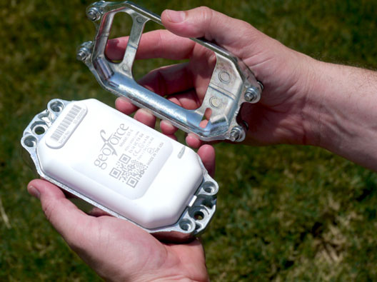
GT-1 asset tracker combines GPS, RFID, and Bluetooth technologies. Photo: Geoforce
Geoforce, Inc. is announcing commercial availability of its GT-1 asset tracking device that can track field equipment in locations and conditions previously too challenging for other devices to function effectively. A globally certified GPS device, the GT-1 enables oil and gas service providers to proactively monitor and share data on vehicles and equipment for more cost effective operations, helping to meet ongoing environmental responsibilities, the company said.
“We have been waiting a long time for a device like this,” said Michael Rolston, operations manager at Permian Equipment Rentals. “It’s small, it’s incredibly rugged, it will last years without replacement. It’s also surprisingly low cost — given all its features and capabilities.”
The GT-1 was previously offered in limited release to several major international service and rental companies beginning in the fourth quarter of 2012. To date, thousands have shipped and are actively tracking oilfield assets around the globe.
Qualcomm Technologies, Inc., has announced the industry’s first 4G LTE Advanced embedded data connectivity platform for mobile computing devices, including thin form factor laptops, tablets and convertibles. The technology, based on Qualcomm Technologies’ Gobi chipsets — the MDM9225 and MDM9625 — is the first embedded, mobile computing solution to support LTE carrier aggregation and LTE Category 4 with peak data rates of up to 150Mbps. The announcement came at the Mobile World Congress being held in Barcelona, Spain, this week.
The Gobi MDM9x25 embedded platform includes an embedded GPS receiver with GLONASS support for enhanced asset tracking, turn-by-turn navigation and other location-based services.
The introduction marks the arrival of Qualcomm Technologies’ third-generation 4G LTE embedded chip, extends Qualcomm Technologies’ modem technology leadership in mobile computing, and promises to deliver the fastest 3G and 4G LTE connections worldwide, while offering the broadest multi-region coverage via a single SKU solution, the company said. PC OEM customers can select from embedded module vendors that support a range of Gobi chipsets, from 3G solutions with speeds up to 42Mbps to cutting-edge 4G LTE Advanced. Coupled with pay-as-you-go, no contract data plans, these products enable thinner, lighter and better connected mobile computing devices running leading operating systems such as iOS, Android, Windows 8 and Windows RT, and support a variety of modules for thin form factors, including PCI Express Mini Card, PCI Express M.2, and Land Grid Array. Additionally, the Qualcomm RF360 Front End solution, providing expanded active band support integral to Qualcomm Technologies’ single SKU LTE World Mode solution will also be included.
“Our broad portfolio of Gobi chipsets — including 3G 42Mbps, 4G LTE and 4G LTE Advanced — features industry-leading LTE multiband support for seamless connections to the fastest networks worldwide,” said Cristiano Amon, executive vice president of Qualcomm Technologies and co-president of Qualcomm Mobile Computing. “This latest addition can be easily implemented across enterprise, SMB and consumer industries allowing end users to download and stream rich HD content, access enterprise applications, share large files quickly and connect virtually wherever they are in the world.”
Qualcomm Gobi MDM9x25 chipsets began sampling to module vendors last November and will enable commercial device launches in the second half of this calendar year.
Navman Wireless, a provider of fleet and asset management technology, announced its acquisition by Danaher Corporation, a Fortune 250 science and technology company. Navman Wireless’ technology currently monitors more than 175,000 vehicles and assets owned by over 14,000 organizations worldwide.
The OnlineAVL2 system, delivered under the Software-as-a-Service (SaaS) model, enables fleet and asset managers to track all vehicle and asset locations in real time as well as control fuel, labor and vehicle/asset operating costs.
Navman Wireless reports it has had five successive years of revenue and installed base growth during which the company entered new vertical sectors including local services, transportation, construction, cold chain, mining, and oil and gas, and opened new geographic markets including Mexico, Italy, China and Taiwan.
“Danaher has the resources, global footprint and commitment to support the continued growth of the Navman Wireless platform and business, along with a strong track record of building brands within its highly diversified portfolio,” said TJ Chung of Navman Wireless. “All of these factors will help us continue to enhance our technology platform, expand into new vertical and geographic markets, and bring the benefits of fleet and asset management to vehicles and assets around the world that are not yet taking advantage of the technology.”
Navman Wireless is Danaher’s first acquisition in the fleet/asset management space, joining Danaher’s portfolio spanning test and measurement, life sciences and diagnostics, dental, environmental and industrial technologies. Financial details of the transaction were not disclosed.
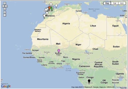
LOCiMOBILE, Inc., a wholly owned subsidiary of GTX Corp, has launched its first enterprise app for companies looking to effectively track and monitor their workforce in real time. Track My Work Force (“TMWF”) is available for download on iTunes, and based on its early success, is in development for release on the Android platform.
Once downloaded on either an iPhone or iPad, the app works in the background and reports the whereabouts of that device back to the GTX Corp monitoring back-end. The app was designed for small- to medium-sized companies that have a mobile sales or service workforce and need to know the location of their reps in real time. Companies in the U.S., Canada, Czech Republic and Morocco, in industries including transportation, construction, plumbing, IT, medical and pharmaceutical, have already deployed the TMWF app and the GTX back-end monitoring platform.
In January, a pharmaceutical company based out of Morocco that services 25,000 pharmacies across several North African countries deployed TMWF for 150 of its sales reps.
“Our diamond delivery business relies heavily on our traveling sales representatives in order to maintain relations with existing customers as well as meeting new ones. GTX Corp’s Track My Work Force app was extensively tested during our system trial,” Jack Daynes of the Diamond Group said. “The results were such that we implemented the program immediately and haven’t regretted it in the slightest. Both the pricing and the service that we’ve received have exceeded our expectations.”
Companies can easily deploy this technology by leveraging the mass adoption of smartphones and tablets in the workforce, said GTX Corp. In January, a pharmaceutical company based out of Morocco that services 25,000 pharmacies across several North African countries deployed the app for 150 of its sales reps.
“We are very pleased with the initial feedback and potential of this app,” said Patrick Bertagna, GTX Corp CEO. “There are tens of thousands of companies all over the world that can benefit and increase customer service, productivity and security from two-way GPS technology and are now able to implement this technology with a simple download.”
The TMWF app is an efficient and cost-effective way for business owners and managers to keep track of and manage their mobile work force, GTX Corp said. It’s faster and safer than text messaging and allows the worker to focus on the task at hand rather than spending valuable time calling HQ to check in and report, the company said. The app costs $9.99 initially, with an additional monthly monitoring service fee that costs around $5.00 per user per month.
The company provides a free two-week evaluation for any business with more than five employees, and custom solutions along with a licensable white-label platform for larger companies.
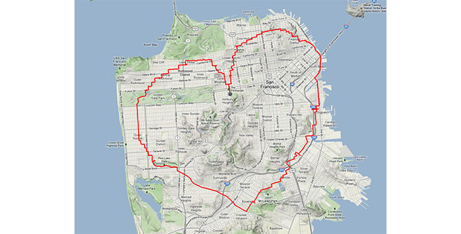
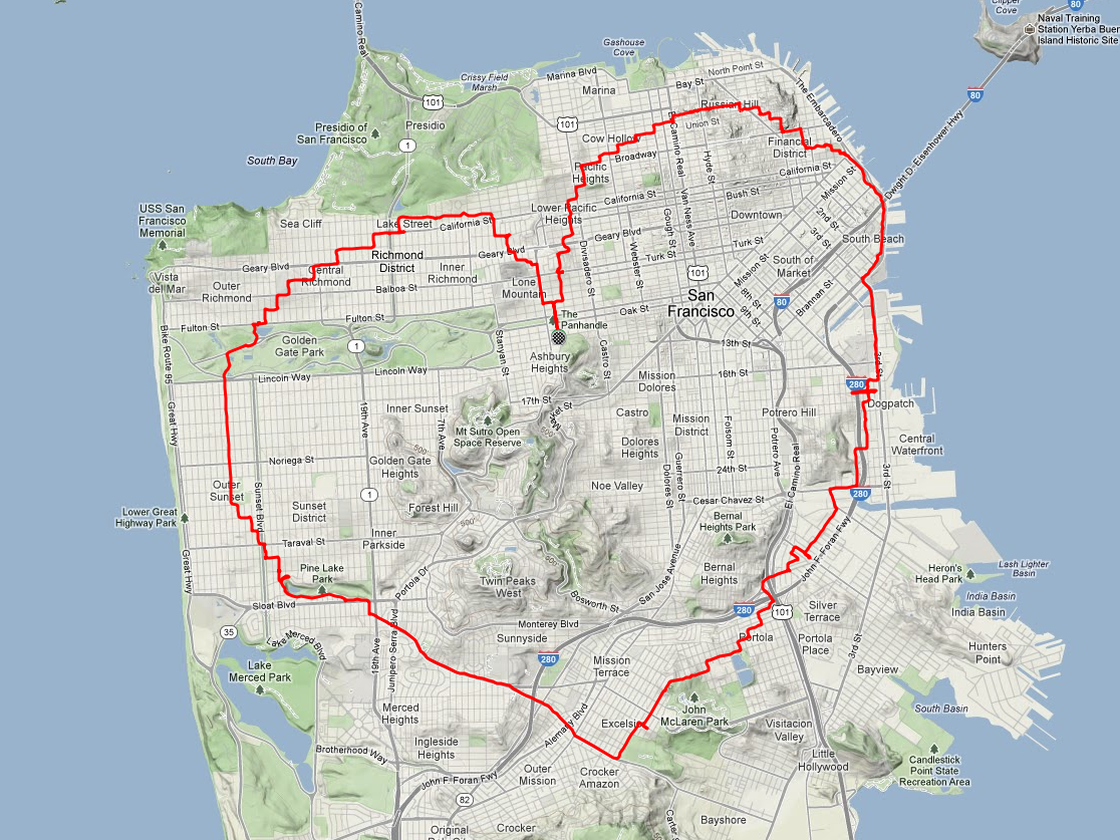
Yes, there is a way. According to Krulwich Wonders, an NPR science blog, a man in San Francisco equipped with an iPhone and tracking app rode his bike 27 miles around the city. Two and a half hours later, Payam Rajabi had etched a heart shape onto a city map.
Click to enlarge.
In 2012, Rajabi had to leave his girlfriend behind in Toronto for a new job. To make sure Clare knew this was a labor of love, Payam included an elevation map of his ups and down in the hilly city.
This year, Verizon is featuring Rajabi — who repeated the feat for cameras — in a television commercial: