GPSTrackIt announces new financing options that significantly reduce the initial cost of implementing its Fleet Manager system and GPS tracking devices. The new “No Pay Until 2014” financing plan program postpones hardware payments until January. This includes documentation fees and the monthly payment, reducing the cost of entry to a flat $24.99 per unit for service. This offer applies to deals of $2,500 or more. Credit must approve the transaction and any term length over 36 months.
Also, the Internal Revenue Service’s Section 179 offers tax incentives for businesses, enabling owners to deduct equipment costs and by providing rebates. The deduction limit for Section 179 is now $500,000. The 2013 Section 179 deduction threshold for total amount of equipment that can be purchased is now $2,000,000. Most new and used equipment, as well as some software, qualify for the Section 179 deduction. Only new equipment purchased in 2013 qualifies for the “50% Bonus Depreciation.”
For more information about GPSTrackIt, their new financing options, or their Fleet Manager vehicle tracking system, visit their website at gpstrackit.com.
INTRUSION SENSORS strive to have a high detection rate and low false alarm rate.
By Eric Olson and Steven Pisciotta
Ongoing threats from terrorist activities at critical facilities require early detection before the threats can reach their target and complete their mission. This has produced the need for advanced security systems to effectively detect terrorist activity, while reducing alarms caused by normal friendly activity. Automatic Threat Assessment, also referred to as Identify Friend or Foe (IFF), is the ability to automatically acknowledge alarms created by friendly assets. It can be achieved with a security system that uses GPS and geospatial data to go beyond the typical intrusion-sensor-only configuration.
The addition of a tracking system associated with friendly vehicles and personnel can provide the missing information necessary to tighten security and reduce the need to take action on alarms caused by friendly targets, and reduce the material and personnel cost of threat assessment. Tracking systems and intrusion sensors can worktogether to automatically classify an actual intruder with high confidence and without operator intervention.
The Verification Problem
Typical intrusion sensors include intelligent fences, ground proximity sensors, radar, LIDAR, and video analytics. The role of the intrusion sensor is to identify a breach and notify security personnel so they may perform verification. Table 1 shows the formal alarm types received from intrusion sensors, which strive for a high detection rate and a low false-alarm rate. For this reason, the nuisance alarm can be problematic as it reflects a real event for the intrusion sensor, but often a non-event for the security operator.
These typical sensors only provide a “suspected intruder” list. The follow-on task is to decide whether or not to reclassify a suspected intruder as an actual intruder. This process is typically a manual task and can be difficult, confusing, and time-consuming.
For instance, a landscape crew will trigger alarms. Even for very accurate systems that can uniquely track the object over a long period, it is highly likely that over the period of time the landscapers are in the area, the track will be lost, causing the system to re-alarm on the same person or vehicle, as it represents a potential intrusion.
If the landscaping crew needs to open a gate, and that gate is integrated into the facility’s access control system via a dry contact or beam breaker device, it may continuously alarm while left open, or at a minimum, in the case of the beam, each time one of the workers or the vehicle passes through the entrance. In these situations, security will either need to validate each alarm by verifying it on a camera or having an officer follow the landscaping crew throughout their route.
The existence of a friendly alarm event that needs continual validation can lead to compacency of security personnel, either not verifying it, or not verifying it in a timely manner.
Table 1. Alarm types.
Combined Detection, Location
A GPS tracking system combined with the intrusion sensors can help identify friends. Tracking systems consist of two main types of locating devices: GPS-enabled devices and wireless transponders.
Modern, low-cost GPS receivers can achieve an accuracy rating of less than 3 meters, provide an update once per second, and do not require visibility to the open sky. Wireless communication transmits the GPS data to the C2 system. A typical data set includes time, date, latitude, longitude, altitude, heading, speed, and quality of GPS signal.
The combination of intrusion sensors and tracking systems can produce automatic threat assessment. Routine situations requiring significant security involvement, such as the landscaping scenario, can be automatically managed by the system. The command and control system has the ability to know friendly targets and their location.
Further, the system can perform a check before actually alarming. In the case of a perimeter alarm, it now has the intelligence to understand, within a level of confidence, that the object detected by the intrusion sensors is the same friendly item being tracking by the tracking system. If the system determines the targets to be the same object, the alarm can be suppressed, eliminating the need for security to verify the event.
THE COMBINATION of intrusion sensors and a tracking system allows for Automatic Threat Detection.
Common Operating Picture
The integration of these types of systems is not complex in terms of how to coordinate data. Interface documents exist for these types of integration and are done on a regular basis. Typical position and target information is communicated over XML in a standard format. However, to gain these benefits, the tracking systems and intrusion sensors must all work within a common geospatial operating picture.
Advantages of geospatial or geo-referenced systems systems include the ability to easily display and control data in a map-based format, allowing tracking systems and intrusion sensors to synergistically perform automatic verification. This combined knowledge of the target’s track also allows the fusing of the GPS data and the intrusion sensor data into a single object and path, aiding security by reducing target and track clutter on his command and control or PSIM (perimeter security information system).
Take for example a guard enabled with a tracking device, performing a tour around a fence protected by video analytics enabled cameras. On a typical PSIM, a normal guard tour would result in two icons on the display, one friendly from the tracking system and one unknown from the video analytics. This scenario would also result in two similar object tracks. Security would need to review the situation and understand that this symbology represents a single target and a single track.
Integrating the tracking system with the video analytics system allows for a fusing of this data, and the resulting command-and-control symbology is a single target and a single track.
Other considerations when combining a tracking system with intrusion sensors include update rate, time and location accuracies, and overlapping coverage.
Ideally, all sensors would be synchronized when it comes to timing aspects, but this is typically not the case. Different timing between data updates and time inaccuracies can result in the inability for the systems to confidently conclude that two tracks were created by the same target. Transport delay, the transmission of the GPS data through the satellite, can also be an issue. For tracking devices, it’s vital for the data to be received by the C2 system with a repeatable transport delay. Variability in the transport delay also decreases the ability to automatically verify the threat.
Geographic accuracy of both the GPS tracker and the intrusion sensor is another important factor in data fusion. Typical GPS trackers have an accuracy rating of 3–10 meters. Actual accuracy varies based upon the visible GPS satellites, tall buildings, body worn, and RF interference. Intrusion sensors also possess an inherent accuracy. Radar surveillance may have a resolution of 1 x 1 meter at close range, but it expands at far range to 1 x 20 meters.
Intelligent fence sensors and video analytic systems can have resolutions that vary from 1 to 25 meters, based on the type of sensor and the terrain. These geographic inaccuracies can be handled to some degree by considering other factors, including heading, speed, and previous track, but it’s important to understand where these inaccuracies can occur.
Overlapping coverage of surveillance sensors also affects data fusion. In the case of track fusion, this ability is only available is areas where both a geospatial intrusion sensor exists and a tracking system is operational. If there are gaps in overlapping coverage, or areas that do not include geospatial- based intrusion sensors, then fusion is not possible in those regions.
Eric Olson is vice president of Marketing at PureTech Systems.
Steven Pisciotta is president of Remote Tracking Systems.
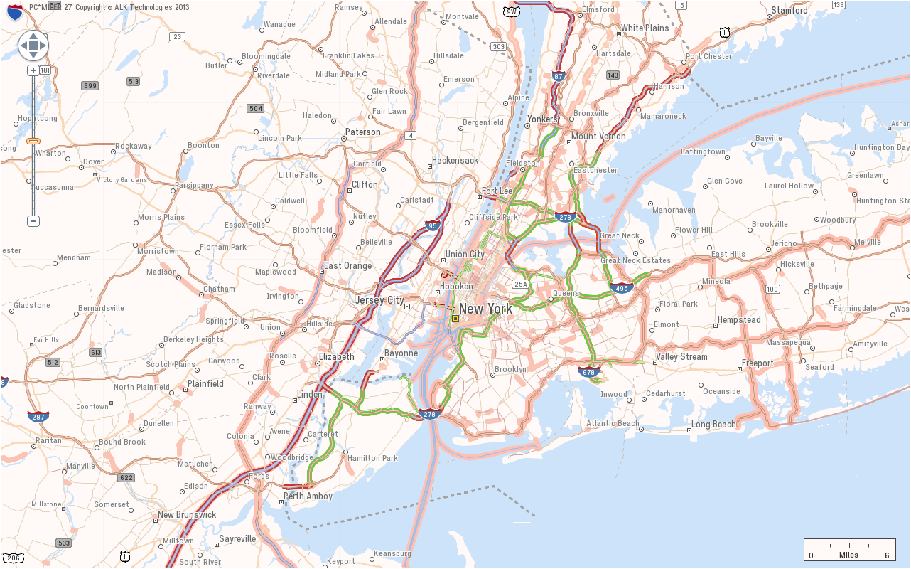
ALK Technologies today released the latest version of its PC*MILER truck routing, mileage and mapping software. PC*MILER 27 features and enhancements include a completely redesigned graphical user interface for maximum efficiency and hours-of-service compliance tools for more precise arrival and delivery time estimates.
“PC*MILER 27 is a milestone for ALK. We’re thrilled to unveil this robust yet easy to use interface with an all new look and feel,” said Mike Bodden, Senior Vice President of Technology, ALK Technologies. “The new UI provides an improved user experience with easier product navigation, resulting in increased productivity.”
The new PC*MILER 27 graphical user interface reflects recent trends in software design that result in more intuitive navigation of the product’s vast feature set. The user interface features a ribbon-style design with newly crafted descriptive icons, a more accessible layout for smoother transition between tasks, and windows that can be floated outside the PC*MILER application to better accommodate workspace needs.
PC*MILER 27 features new hours-of-service compliance tools to help ensure that routes and ETAs will accurately reflect drivers’ available hours. The HOS compliance tools increase the precision of arrival and delivery time estimates and help dispatchers and drivers comply with HOS government regulations. Based on remaining hours, PC*MILER calculates when a driver needs to break, and indicates the designated breaks in the detailed driving directions report, automatically updating on-duty hours. Through the PC*MILER|Connect interface tool, fleets are able to import or export the drivers’ remaining hours associated with specific routes. With the pending new regulations, this is crucial to managing driver compliance and CSA safety scores.
RouteSync is a powerful capability that ensures operational consistency between dispatched routes and actual routes, delivering the guidance to drive the miles that are being billed. With RouteSync, routes and preferences are sent from PC*MILER in the back office directly to the latest version of ALK’s CoPilot Truck navigation software in the cab. In addition to maintaining route compliance, RouteSync reduces non-revenue mileage, improves load profitability and increases driver satisfaction.
Enhanced routing, map data and address matching are a major part of each annual PC*MILER release, ALK Technologies said. As part of ALK’s ongoing effort to track nationwide toll costs in the U.S. and Canada, PC*MILER|Tolls 27 includes four new toll discount programs.
The comprehensive suite of PC*MILER 27 integration tools has also been updated and enhanced. PC*MILER interfaces with all leading transportation, logistics and fleet management systems. These products include PC*MILER|Connect, PC*MILER|TCP/IP, PC*MILER|Mapping, PC*MILER|Spreadsheets, PC*MILER|BatchPro and Multi-Version Switch.
PC*MILER runs on Microsoft Windows, UNIX, and Linux platforms, as well as IBM AS/400 (iSeries) and mainframe computers. PC*MILER is also available as a web-based application.
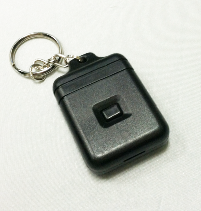
The Instant Alert Device enables drivers to immediately notify dispatch. Photo: GPSTrackIt
GPSTrackIt has developed an Instant Alert Device that can attach to a driver’s keyring, to enable mobile workforce team members to communicate with their dispatchers or fleet managers. If a driver is in trouble, help can be on the way with the touch of a button.
The compact communication device enables drivers to signal for help even if they’re not with the vehicle. Dispatchers are alerted that a driver is in trouble, and can provide vehicle location information to first responders for expedited assistance.
“The device works in a similar fashion to an electronic key,” explains Eddie Bermudez, GPSTrackIt product manager. “It’s a small plastic box with a single button on it. The driver can carry it on his or her keychain. So even if they’re not with the vehicle they can still call for assistance.”
When the button on the device is depressed, it sends a signal wirelessly to a receiver connected to the tracking device in the vehicle. The Instant Alert Device has a range of up to 500 feet.
Bermudez offered an example. “Let’s say you dispatch someone to a remote oil field and there is no cellular communication out there. The tracking device uses both GPS and satellite communications, a combination that provides optimum coverage. The worker can use the Instant Alert Device to notify their team members back at the office if something is wrong or to acknowledge the completion of a task. This gives real-time, up-to-the-minute notifications to the alert contacts via Fleet Manager.”
The feature can be used with any type of switch, button or Power Take Off (PTO) that connects to an input wire on the tracking device.
The storm chasing and weather community is honoring three storm chasers killed in an Oklahoma tornado on Friday. Tim Samaras, his son Paul Samaras, and Samaras’s chase partner Carl Young are being honored via the Spotter Network, where their initials are being spelled out.
The Spotter Network is a website used by storm chasers to follow weather movements. Users have been adding position locations to spell out the initials TS, PS, and CY, shown here in an image at sfgate.com.
The Samarases were well known to TV viewers, having been prominent subjects of the Discovery Channel series “Storm Chasers” and frequent contributors to The Weather Channel. They weren’t working for either channel last week, both networks said.
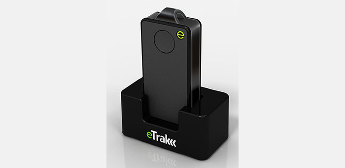
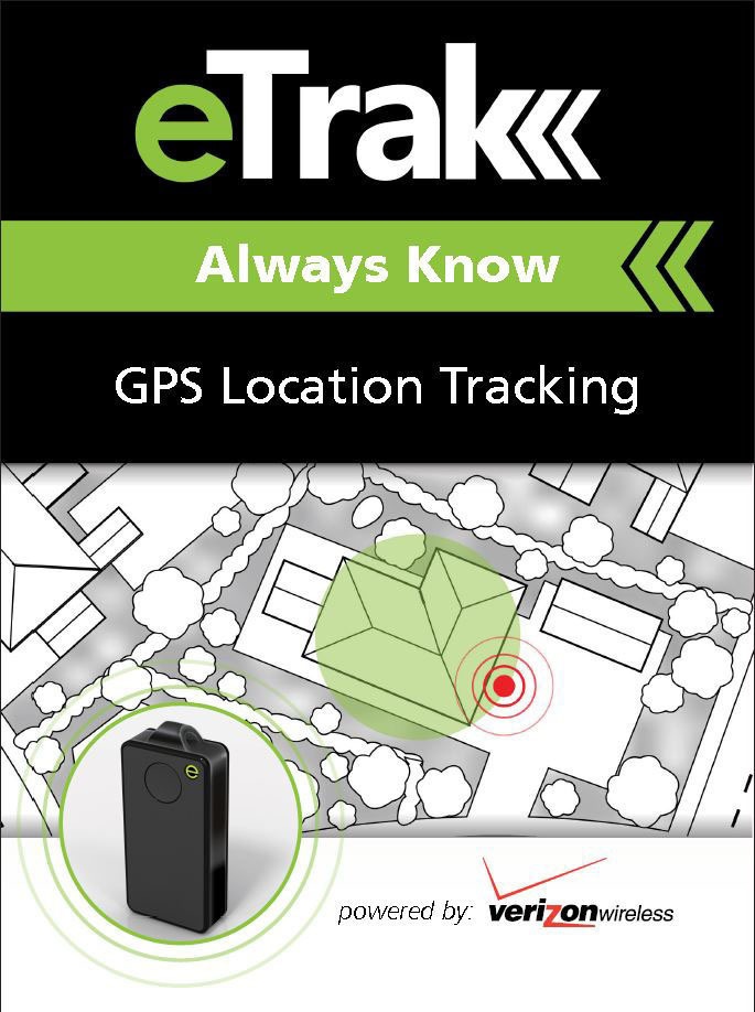
eTrak has released its GPS+ line of consumer and commercial tracking products. GPS+ is eTrak’s patent-pending technology that integrates Wi-Fi, cellular triangulation and GPS to achieve the most accurate positioning possible, both indoors and out, eTrak said.
GPS+ delivers accurate location in real time directly to a smartphone, tablet or computer. eTrak products also contain geofencing capability, which triggers notifications if the device goes beyond preset boundaries. Additionally, the notifications provide a map and address with the location of the device.
“Small and large businesses will benefit from tracking their assets with loss prevention and cost savings,” said eTrak CEO, John Harris. “They will also be able to keep their employees safe and know if they are in danger or need assistance.”
Set-up and the use of eTrak products is simple, the company said. Users can go to eTrak.com and start tracking from any smartphone, tablet or computer and instantly see the location of the eTrak device. The eTrak consumer device is also equipped with an emergency panic button that sends help requests to predetermined recipients in the event of an emergency.
“eTrak is the size of a domino and weighs less than an ounce,” Harris said. “eTrak provides the longest battery life available, and is a low cost personal emergency-response product. And with Verizon’s industry-leading coverage map, it works almost anywhere.”
The eTrak product line encompasses commercial applications, as well as consumer segments including health-impaired, special needs, teens and pets. eTrak also supplies custom design and development services.
Game Golf, a wearable technology and integrated software platform for golf, is available for pre-0rder, and expected to be released this summer. Backed by professional golfers Graeme McDowell and Lee Westwood, it seamlessly records a player’s golf game to make the game more engaging, visual, interactive, shareable and social, both on and off the course.
“Game Golf not only gives everyone access to crucial data to dramatically improve your golf game and handicap, but it also makes playing more motivating, rewarding, social and fun,” said Graeme McDowell, 2010 U.S. Open Champion and Game Golf investor. “The product is extremely intuitive, doesn’t disrupt your game and is essential for any golfer looking to understand their game better, knock down their handicap, give themselves a competitive edge and compete with their friends and family across the globe.”
Game Golf is designed by fuseproject and Yves Béhar, CEO of fuseproject and Chief Creative Officer at Jawbone, the maker of the wireless Jambox speaker. The Game Golf elegant and discreet wearable device tracks the data around the course, and uploads the data automatically to an intuitive app which allows you to track, analyze and share the data collected. It tracks the most important statistics from your golf game, including club-by-club performance, fairway accuracy, greens in regulation and putting.
“The design of the Game Golf app and product has been closely integrated: a beautiful and dynamic presentation of play data, easy and fun ways to share, non-disruptive hardware and experience,” said Yves Béhar, CEO of fuseproject. “The design and user interface is crafted to deliver a 21st-century experience of the game.”
The product uses a combination of positional technology, motion sensors and near field communication to capture the golfer’s data from the course. The device is engineered to be power efficient and extend battery life beyond that of the average smartphone and provides two full rounds of tracking on one charge. Data from the device is synced to the cloud via Bluetooth to a smartphone or via USB to a PC.
“The golf community has been calling out for a product that tracks their game effortlessly, shares results with friends and provides intuitive data with which they can analyze to constantly improve their game — and Game Golf is here to provide that,” said John McGuire, CEO and Co-Founder, Game. “A new era of quantification and gamification is rapidly and radically changing the way we live, work and play. Existing golf technologies only provide technology that helps on the course, but we provide the complete package, giving you everything you need to improve your game and compete before, during and after you take to the course.”
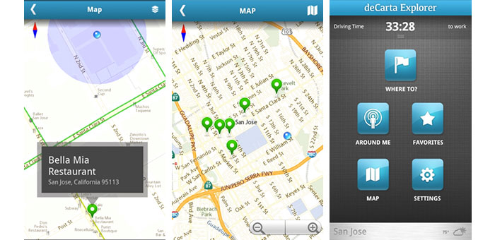
deCarta, Inc., an independent LBS technology company, has introduced its Xplorer V8 navigation platform, combining deCarta’s cloud-based navigation service with customizable client-side libraries. This combination gives application developers the ability to quickly add vector mapping and turn-by-turn navigation to any mobile application, from local search to fleet management, providing users with fast, accurate driving directions to a destination or search result.
Xplorer V8 is available as a white label application or as client-side libraries depending on the degree of customization required. deCarta’s L2 advanced local search technology is fully integrated into the platform to help users find destination addresses or local points of interest (POI).
deCarta navigation technology powers products such as GM OnStar, Ford Sync, INRIX, Appello, TCS and MotionX GPS Drive. With Xplorer V8, deCarta lets developers tightly integrate that functionality into their own applications or to build custom navigation applications. Examples of the use of Xplorer V8 include:
Local search applications that offer route guidance to the search destination from a mobile phone or tablet.
Branded navigation applications for global automotive companies.
Mobile applications that display places of interest in a vector map display with smooth panning, rotation and zooming.
Fleet management solutions that offer route guidance and tracking to ensure that drivers are directed efficiently to their destinations.
deCarta has already engaged with customers in each of these areas and expects to be announcing new partners for Xplorer V8 in the coming months.
The Xplorer V8 platform consists of a cloud-based service and a set of core client-side libraries that work together to provide a high-quality navigation experience.
The Xplorer V8 Navigation Cloud Services provide local search and navigation response based on deCarta’s geospatial technologies. deCarta hosts these services in global data centers in Santa Clara, London, Seoul, Beijing and Sydney.
The Xplorer V8 CoreLibraries are integrated into client side applications. They support three critical functions that can be used together as a group or individually as needed by the customer.
Local Search: Single line search and geocoding based on deCarta’s L2 technology.
Guidance and Routing: Voice guided navigation, displayable as an overview, a list of directions or in turn-by-turn sequence.
Map Display: Vector-based maps that support turn-by-turn navigation, voice guidance, 3D display, immediate off route determination and rerouting.
Xplorer V8 libraries are compatible with all Android-based platforms for mobile devices, tablets and automotive embedded systems. Apple iOS versions will be available at the end of June.
For companies interested in a turn-key navigation solution, Xplorer V8 is also available as a white-label navigation application that can be branded to match the customer’s needs.
“Industrial-grade navigation engines are extremely hard to develop. To meet the demanding consumer expectations, they have to perform well, with speed and accuracy across a wide range of circumstances,” said J. Kim Fennell, CEO of deCarta. “Xplorer V8 packages all of deCarta’s navigation experience and makes it available for application developers to integrate directly into their apps.”
Xplorer V8 is available immediately for deployment in North America and Australia, with Western Europe coverage coming in June. Other countries will be included in the following months.
Polaris Wireless, a high-accuracy, software-based wireless location solution company based in Mountain View, California, today announced that the company closed on a recapitalization of existing equity interests on April 25, 2013. As part of the recapitalization, Polaris Wireless completed a Series C financing with $10 million from Industry Ventures, a leading investment firm focused on the venture capital market, and Industry Ventures Managing Director Victor Hwang has joined the Polaris Wireless Board of Directors.
“Industry Ventures seeks to invest in market leading growth companies and we believe Polaris Wireless is a clear leader in the wireless location market,” said Hwang. “We are very excited about Polaris Wireless’ strong growth trajectory and global presence, and look forward to working with Manlio Allegra and the senior team at Polaris Wireless in their next chapter of growth.”
The investment by Industry Ventures also returned capital to Series A investor Draper Fisher Jurvetson (DFJ) and will also be used to fund Polaris Wireless’ future international growth.
“We look forward to an exciting new growth chapter for our company with Industry Ventures by our side,” said Manlio Allegra, Polaris Wireless CEO and Co-founder.
Polaris Wireles experienced a record increase in revenue and profitability in 2011 and 2012, driven by aggressive growth for its location solutions across the globe. Twenty-four U.S. wireless carriers, six managed services partners, and 15 international deployments now rely on Polaris Wireless location solutions to enable emergency call applications, lawful and mass location surveillance, and other location-based services.
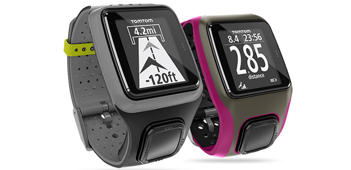
This summer, TomTom will make available a new range of GPS watches to deliver at-a-glance performance information for runners, cyclists and swimmers. The ultra-slim TomTom Runner and TomTom Multi-Sport GPS sport watches feature an extra-large display, full-screen graphical training tools, and one-button control to make it easier for users to access the information needed to stay motivated and achieve their goals.
“We know that most GPS watches on the market are too bulky and complicated to use while training,” said Corinne Vigreux, managing director, TomTom Consumer. “Just as we developed easy-to-use navigation products that changed the way that people move from A to B, we have developed a range of ultra-slim GPS sport watches that are far more comfortable to wear and far easier to use. Runners and multi-sport athletes can now view their performance information at-a-glance, making it easier to achieve their fitness goals.”
The new TomTom watches feature an extra-large, high-resolution and high-contrast display that makes it easy for runners and multi-sport enthusiasts to quickly see their distance, time and pace while they workout even in bright sunshine, TomTom said.
The new watches feature TomTom’s Graphical Training Partner. Easy-to-read full-screen graphics help users get the most out of their workouts. They can view their real-time performance at-a-glance with three graphical training modes:
Race: Race against a personal best or most recent run. Quickly track performance with real-time graphics, to continue to improve run-after-run. Goal: Set a distance, time or calorie goal and see progress toward that goal with simple, full-screen graphics and alerts. Zone: Set a target for pace or heart-rate (with optional heart-rate monitor) and track progress in a simple full-screen graph throughout a workout.
The new TomTom range includes an intuitive one-button control that enables users to easily navigate up-down-left-right through menus to access key stats and watch features, the company said. Unlike the majority of existing GPS watches on the market that feature multiple small and hard-to-operate buttons, the one-button control is easy to operate while moving and can be easily controlled in all weather conditions and while wearing gloves.
In addition to their ability to deliver at-a-glance performance information, the TomTom Runner and TomTom Multi-Sport include advanced features designed to address the needs of runners and multi-sport enthusiasts alike:
Ultra-slim design: At just 11.5mm, the slim design of the watch module comfortably fits men and women, and all wrist sizes. Indoor tracker: Accurately track indoor runsusing built-in sensors to count strides, so that users can monitor pace and distance even while running on a treadmill. QuickGPSFix: Get started faster by using the latest in GPS and GLONASS satellite technology to quickly find their precise location. Multi-platform compatibility: Sync, analyze and share stats on popular running sites and community platforms, including the TomTom MySports website, MapMyFitness, RunKeeper, TrainingPeaks and MyFitnessPal. Super-tough display: Scratch- and impact-resistant glass stays easy-to-read, workout after workout. Weather- and waterproof: Waterproof up to 50 meters/5ATM. Long-lasting battery: Up to 10-hour battery life (GPS mode). Bluetooth smart: Connect to sensors using the latest wireless technology. Heart rate monitor: Use the Bluetooth Smart Heart Rate Monitor to track training zone for weight control, performance or speed.
TomTom Multi-Sport includes all the features included in TomTom Runner, and also allows multi-sport athletes to track their distance, time, speed and other key metrics when they cycle or swim. The TomTom Multi-Sport is also enhanced with the following features and options:
Dedicated bike mount: Easily see key stats at-a-glance with the specially designed bike mount. Cadence sensor: Track cadence, speed and distance, indoors and out. Built-in altimeter: Accurately track elevation, ascent, descent and grade with the built-in barometric altimeter. Swimming motion sensor: Check detailed swim metrics such as laps, strokes, time and speed, and calculate a SWOLF score to show swim efficiency.
The TomTom Runner and TomTom Multi-Sport will be available in Summer 2013.
Tractor rollovers are the leading cause of death among farmers and claim about 250 lives each year, according to the National Institute of Occupational Safety and Health (NIOSH). These accidents are deadly because they often occur far away from farmers’ homes or roads and they may be unable to reach a phone to call for help. Now, University of Missouri researchers have developed an application for smartphones that uses GPS systems to locate farmers who have rolled their tractors.
The app, called VRPETERS (Vehicle Rollover Prevention Education Training Emergency Reporting System), uses sensors and GPS capability built into smartphones that can detect rollovers. Once the app detects a rollover, it sends an automatic emergency e-mail and phone message with the coordinates of the accident location to family or emergency responders.
“The tractor is the main power source for field operations, and tractor rollover accidents have been killing people since the beginning of their use in agricultural production,” said Bulent Koc, assistant professor of agricultural systems management at MU and developer of the app. “More and more farmers are using their smartphones to monitor weather or calculate production inputs while operating machinery. Since they already have their phones with them, installing VRPETERS could help save lives.”
Data from the NIOSH show that one out of every 10 tractor operators will roll a tractor at least once. NIOSH also notes that only half of the 4.7 million tractors on U.S. farms have rollover protection. In order to minimize false alarm rollovers on the app, Koc and his research assistant Bo Liu designed a device that must be attached to the tractor. This device helps calculate the stability characteristics of the tractor and will provide a warning to the driver when the tractor approaches its rollover point.
“Many farmers think they can jump out of their tractors in the event of a rollover, but this isn’t the case usually,” Koc said. “Side rollovers can occur in just three-quarters of a second and most people need a second or more to react to an event. So, VRPETERS can benefit farmers when a rollover occurs because they often can’t reach their phones to make an emergency call.”
VRPETERS can benefit more than just farmers, as the app also can be used on construction vehicles, trucks, snowmobiles, military vehicles, riding lawnmowers and all-terrain vehicles.
In addition to the rollover device installed on tractors and other dangerous equipment, Koc and Liu designed another device that can be used with VRPETERS. This device can be installed on vehicles and can be used as a backup to stream data to a smartphone or tablet. “With this additional device, parents or fleet managers can obtain real time data on how machines are being used,” Koc said. “If the device detects improper operation, an intervention can occur before an accident happens.”
Initial testing of VRPETERS was done using a remote-controlled model tractor. Once fully tested on a standard tractor, Koc and Liu will look for an industry partner to market the app.
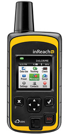
DeLorme has announced the launch of its newest product, the inReach SE (Screen Edition) satellite communication device. With 90 percent of the world’s surface lacking cell phone coverage, inReach SE is designed for the traveler or outdoor adventurer to keep them connected and safe anywhere in the world. The expanded standalone capabilities of inReach SE include a color screen, virtual keyboard, slim design and long-lasting internal lithium battery. In standalone mode, inReach SE provides free-form texting capabilities of up to 160 characters to any cell phone number, email address or social media page.
Using DeLorme’s Earthmate App, inReach SE pairs wirelessly with iPhone, iPad and iPod touch to access topographic maps and NOAA charts and to make text messaging more convenient. inReach SE is also compatible with Android devices.
With the ability to maintain satellite signal lock even in difficult GPS environments, inReach SE also offers global SOS capabilities, adjustable tracking intervals from 10 minutes to four hours, and remote real-time follow-me/find-me tracking and ping-me locating. In the event of an emergency, the interactive SOS capability of inReach automatically triggers remote tracking and allows users to describe and update their situation so proper resources can be deployed, DeLorme said.
“Whether you’re deep in the backwoods, floating on a remote lake, or simply traveling abroad, anyone can benefit from the comprehensive functionality of inReach SE,” said Michael
Heffron, DeLorme CEO. “Over the last two years we have been listening to customer feedback, so the next generation of inReach includes many new features based on their input. The internal rechargeable battery and the on-screen, free-form texting are especially beneficial, making on-the-go communications more convenient and delivering peace of mind to family and friends easier than ever before.”
inReach operates over the Iridium satellite network, providing global two-way satellite communications, high network reliability and low-latency data links (less than 60 second delivery of messages end-to-end) anywhere on Earth, with no gaps, fringe or weak signal areas, DeLorme said.
The follow me / find me tracking feature of inReach provides GPS position updates allowing family and friends to follow the user’s trip as it happens. Family and friends can log into a dedicated MapShare page to follow a detailed breadcrumb trail, ping a location, and send messages to the inReach owner. In the event of an emergency, the built-in SOS button can be activated to trigger a distress alert with delivery confirmation and it automatically activates the remote GPS tracking feature. GPS tracking assists search-and-rescue personnel with homing in on the user’s location, whether stationary or on the move.
Pairing the inReach SE via Bluetooth with the Earthmate App turns a mobile device into a global satellite communicator and navigation tool. Real-time GPS location, tracking and text messages are overlaid on the digital maps for easy navigation and position location. inReach owners get exclusive, unlimited access to DeLorme’s topographic maps and North American NOAA charts, which can be downloaded via an Internet connection prior to departure and remain available in the Earthmate App even when outside cellular coverage.