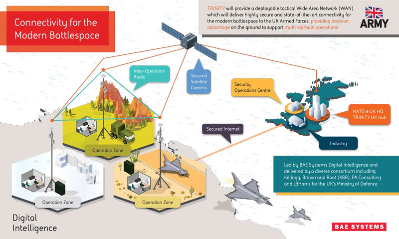
BAE Systems has been awarded an £89 million contract by the Ministry of Defense (MOD) to enhance front-line connectivity for military personnel, UAVs, combat vehicles, fighter jets, aircraft carriers and military commands.
The contract will be dedicated to the research and development phase of BAE Systems’ deployable tactical wide area network (WAN), Trinity. Trinity is due to be delivered in December 2025.
Under the contract, BAE Systems will lead an alliance of trusted partners, including Kellogg, Brown and Root (KBR), PA Consulting and L3Harris, to design and manufacture Trinity. The companies aim to deliver a highly secure battlefield internet capability to UK forces, which will sustain battlefield awareness and intelligence sharing through a myriad of adversarial attacks.
Trinity’s resilience is based on its composition, the company said. It is made up of a series of nodes, each able to add, access and move data in a secure network. If several nodes are damaged in warfare, the remaining automatically re-route to maintain optimum network speed and flow of information.
An exclusive interview with Mark Holbrow, VP of Product Development, Spirent Communications and Roger Hart, Sr. Director of Engineering, Spirent Federal Systems. For more exclusive interviews from this cover story, click here.
What are your roles?
MH: Our business is based in the UK. I am responsible for the vision and direction of the Technology portfolio required by Spirent’s Positioning Technology business unit.
RH: I am responsible for the U.S. add-on components to the simulator, the restricted signals, and support for the U.S. government labs and contractors.
How have the need for simulation or the requirements for it changed in the past five years, with the completion of the BeiDou and Galileo GNSS constellations, the rise in jamming and spoofing threats, the sharp increase in corrections services, and the advent of new LEO-based PNT services?
MH: I would say that the need for thorough and comprehensive testing has never been greater. That need is being driven on multiple fronts due to the understandable pressure on PNT systems needing to deliver enhanced accuracy, reliability and resilience, in the presence of emerging threat vectors and an expanding application space that’s utilizing ever more complex combinations of new and enhanced signals and sensors of opportunity. Underpinning Spirent’s leadership in ensuring the test needs for this evolving, challenging and increasingly diverse market are its team, its technology and its partners. That team is well-established, dedicated and highly experienced — their sole focus is designing, manufacturing and supporting PNT test solutions. The technology focuses around our pioneering dedicated SDR hardware platform and software simulation engine, which allied provide performance, scalability and flexibility, within an open accessible architecture. In addition, close collaboration with our selected partners ensures the opportunity to support and integrate new and emerging PNT technologies through their tools, applications and hardware.
You mention the advent of LEO. A key reason why Spirent was first to market and successfully supported an early LEO + GNSS receiver test-bed (through close and collaboration with Xona and NovAtel) was driven by team, technology and partners.
Two other important areas that have definitely continued to grow and evolve in importance and priority have to be increased realism and test automation. Both are areas in which Spirent continues to prioritize and invest R&D dollars.
Spirent’s integrated, software-defined wavefront simulation system for a 5-element controlled reception pattern antenna (CRPA). Spirent solutions support 16+ antenna elements. (Image: Spirent)
With all these additional signals, is it still a single simulator or do you have to somehow split it up into different modules?
MH: Good point. Again, a key element with the Spirent solution is that it is very scaleabale and flexible. Spirent has a generic SDR that can be re-purposed to simulate whatever signals are required. That way, we can compile different signals from either one radio or multiple radios coming from the same system. Together with being able to bring in multiple chassis to gradually grow the simulation solution, while also maintaining for each of those signals the fidelity, channel count, and accuracy that customers demand.
Including every signal currently available?
MH: Absolutely, sir. In fact, signals that are still on the drawing board as well. We can enable the user with effectively an arbitrary waveform simulator or ‘sandbox’ to experiment with different modulation schemes, different chipping rates, codes, bandwidths and navigation data content. So, in addition to using that architecture to generate the signals, we allow customers to experiment with it themselves. That’s certainly accelerated over these last five years, and there’s no sign of it stopping. We’re currently working with customers and partners all over the globe who are developing both brand new and emerging PNT systems, whilst also providing all the vital simulation tools to aid the R&D of existing and planned SIS evolutions.
RH: The increasing number of signals that we can support multiplies the permutations and combinations of test cases that users can do. There is a lot of emphasis also on the user interface side of things, so that from one interface you can also easily control all these interfaces with third-party tools, because proliferation of signals produces a huge possible test volume.
What are the specific challenges in realistically simulating new LEO-based signals and any new services being developed for which you don’t have any live sky signals to record yet, only ICDs and other documents?
MH: Again, great question. The key reason Spirent excels in this arena is that the core simulation engine and SDR are agnostic of the constellation and signal type that’s being generated. So, the underlying principles of accuracy, range rate, pseudo-range control, and delay, together with the RF fidelity from Spirent’s SDR+ Sim engine, can be readily manipulated to simulate the wealth of emerging signals, including LEO.
The other area that becomes very important is that if we do not have sight of the ICD, we can enable customers to use our tools to readily populate elements of that ICD themselves. That way, the best of both worlds is achieved, i.e. a turnkey SIS solution, or we can just enable the customer to do it themselves.
Are accuracy requirements or any other requirements for simulation increasing to enable emerging applications?
MH: They are. Both current and emerging test needs are continuing to drive the need for enhanced simulation realism. Always a tough nut to crack, but our hard-won experience and expertise, allied with continuing adoption of latest-generation technology, is allowing us to take some significant strides forward. Real-world testing has an incredibly important role to play and that’s why at Spirent we continue to invest in and develop the GSS6450 Record & Playback System (RPS). However, we are also on that quest for the ‘Holy Grail’ that has all the well understood and necessary advantages of lab-based testing but with the simulation environment being as true to the real world as possible.
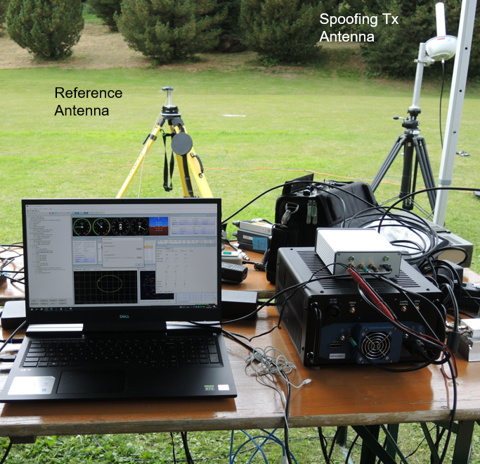
A German Armed Forces test center, WTD-61, recently used Spirent’s new Field Simulator to conclusively demonstrate the susceptibility of some UAS to spoofing. (Image: Spirent)
A further area where both current and emerging test needs are demanding more and more from the test environment is resilience testing. Spirent now supports a multitude of vulnerability and corresponding mitigation/prevention test cases. Those test cases become increasingly complex as multiple combinations of the threat/mitigation surface evolve — including jamming, spoofing, cyber-attack and CRPA.
Many of these test cases are driving the state of the art and, especially in the case of CRPA testing, Spirent’s purpose-designed SDR comes into its own. Technology bakeoffs and corresponding customer adoption have shown that only through the use of that dedicated purpose-built technology, the simulator test bed can deliver the necessary carrier and code phase stability, very low levels of uncorrelated noise across antenna elements and high J/S that is demanded.
Again, with respect to flexibility, we also support ways to let customers generate their own IQ data. That data can be streamed into the Spirent simulator and combined sympathetically and coherently with the signals generated inside the platform. So, you can layer new signals on existing ones, or introduce a completely new dedicated IQ stream.Finally, hardware-in-the -loop (HIL) testing requirements continue to be a crucial aspect in test coverage. Whether that application is automotive, projectiles or autonomous vehicles, the need for lower latency and higher 6DOF sampling to capture as many trajectory nuances as possible continues to grow. Spirent’s 2KHz system achieves very high iteration rates (SIR) and <2msec latency.
What are the key differences between your simulators for use in the lab and those for use in the field? I assume that the latter are lighter, smaller, and less power hungry. Do they use modules so that users can pick the ones they need for a particular test?
MH: We do support in-the-field test use cases. Spirent has record-and-replay (RPS) systems to take soundings in a wide-band RF environment, record them, then bring them back into the lab for replay. They are sized to fit into a backpack, battery-powered, accessible, and easy to use.
Recently, we have also taken some of our signal generator IP and been able to create a smaller form factor portable simulator for outside use. Its footprint is considerably smaller than that of one of our lab-based simulators. It’s primarily a mechanism for testing the resilience in the field of devices under test. Armed with a Spirent simulator and the appropriate transmit licenses, a customer can put their DUT through an array of vulnerability test cases in a live real-world environment.
You mentioned licenses. As far as jamming, specifically, and maybe spoofing, I presume that you’ll need a license for a specific time and place and that you will have to be far away from, say, an airport.
Absolutely. Right. The details will vary depending on the jurisdiction, but you will need a license to transmit. And, as you rightly say, often those places will be very remote so as not to interfere with the public. We’ve had instances where we’ll work with a customer who has those appropriate licenses and then we can provide this equipment for them to be able to put it through a battery of tests.
You generate the spoofing in your simulator, of course. Do you also generate the jamming inside the same box or from a separate jammer nearby?
It could be either. We can use our simulators to generate internally wide range of interference signals supporting a wide bandwidth, high max o/p power and large dynamic range. This is especially important in instances of CRPA testing, in which it is vital to accurately reproducing a jamming wavefront commensurate with the arrival angle and delay incident at each antenna element. Correspondingly, we support turn-key solutions to connect, control and integrate 3rd party external signal generators into the test scenario.
Are you at liberty to describe any recent success stories?
We have a Xona simulator. So, this is back on the topic of LEO. We’ve recently released that in partnership with Xona. We are also working closely with Hexagon. All those things I mentioned earlier about enabling the customer to use the flexible features that we have, that is where it came into its own. That’s certainly a significant recent success.
We’re continuing to add many realism-related capabilities, including simulating the vibration and temperature effects of inertial systems. Working with a Swiss partner called Space PNT, we’ve recently introduced another LEO-based product, called SimORBIT. That tool enables us to generate incredibly representative and accurate LEO orbits that also include gravitational effects based upon the SV size. We recently introduced a new software tool to support “GNSS Assurance” requirements.
We have a newly patented cloud-based software application called GNSS Foresight that enables users to understand the GNSS coverage they would expect during a particular time, date location and trajectory inclusive of the 3D environment they would be experiencing. We continue to evolve the tool to support real-time operation to enable it to deliver aiding content to appropriately equipped systems.
We continue to be able to support more and more automation. Automation has always been important, but with ever increasing demands of test asset utilization and in a post-pandemic world of remote working, it’s more important than ever right now. The number of test cases and corner cases required and the amount of equipment, coverage, and efficiency required, which was being demanded by using our kit means that automation is vital. So, we’ve introduced several new automation tools to build up on top of our current SimREMOTE interface.
Spirent has also developed a simulation test solution for the Galileo Open Service Navigation Message Authentication (OSNMA) mechanism. SimOSNMA is designed to work with Spirent’s GNSS simulation platforms to test OSNMA signal conformance, which will bring new levels of robustness for both civilian and commercial GNSS uses. SimOSNMA provides developers with vital new simulation tools to test for OSNMA, the security protocol that enables GNSS receivers to verify the authenticity of signals distributed from the Galileo satellite constellation. Designed to combat spoofing, OSNMA ensures that the data received is authentic and has not been modified in any way. It is currently completing the test phase before its formal launch, and SimOSNMA enables developers to simulate and test OSNMA signals and features, allowing GNSS receiver manufacturers and application developers to accelerate and assure development programs.
The United Kingdom’s first fully electric self-driving bus began service on public roads from the Didcot Parkway railway station in June, reported the BBC.
First Bus, the UK’s largest bus operator, said the bus’ radar, lidar and artificial intelligence technology could safely steer, accelerate and brake without human intervention.
While the bus is fully autonomous, it does have a safety driver who is able to override operations if needed.
The 15-seat bus makes a six-mile loop from the station to Milton Park in Oxfordshire, UK, and runs six days a week every 40 minutes.
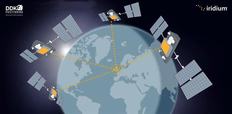
Topcon Positioning Systems has made an investment in DDK Positioning, a UK-based GNSS receiver and precise point positioning correction services company. DDK Positioning delivers services over the Iridium network to provide global precision positioning services that can augment GNSS constellations enhancing accuracy for critical industrial applications.
“With the expansion and growing success of this business, specifically in the marine sector, a closer cooperation will ensure optimal integration for the highest possible accuracies and performance in the most demanding applications,” Ian Stilgoe, vice president of Emerging Business at Topcon, said.
“This partnership provides an extraordinary opportunity for our two companies to work together in pursuit of our shared ambition — providing a robust, resilient and truly unique GNSS positioning service,” Kevin Gaffney, CEO of DDK Positioning, stated.
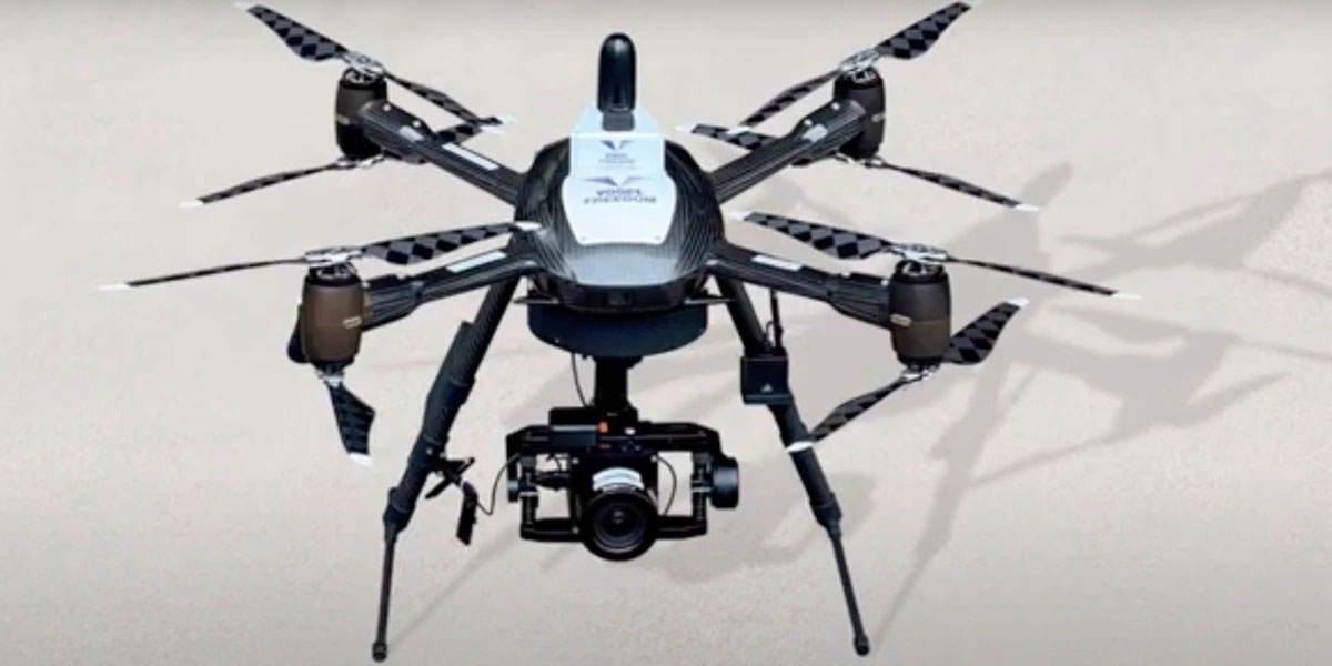
Plowman Craven, a United Kingdom-based aerial surveying company, has launched the Vogel Freedom UAV data collection solution designed for owners and operators of rail networks.
The Vogel Freedom UAV solution aims to solve issues rail operators face in carrying out network surveys, including traffic disruptions and dangers created for workers needing access to infrastructure for ground point sensors.
The platform requires fewer ground points to deliver topographical surveys. It can also produce sub-5 mm accurate rail system models using off-track sensor placement.
Operating from offices in London and Hertfordshire, Plowman and Craven is one of the largest infrastructure surveying and inspection businesses in the U.K.
“We developed Vogel Freedom in response to ever-increasing industry challenges and needs,” Steve Jones, head of new business at Plowman Craven, said. “It removes previous limitations to surveying and can add substantial value… all while improving workers’ safety and ensuring a safe and efficient rail service for customers.”
Precision agriculture (PA) — which uses electronic information to better manage spatial and temporal variability in crops, livestock, forestry and other biological systems — is profitable, as proven by the rapid and widespread adoption of GNSS guidance for mechanized agriculture. Other enablers of PA include variable rate technology (VRT), remote-sensing using satellites and unmanned aerial vehicles, geographic information systems (GIS) and soil sampling.
In my introduction to our January cover story, I requested pointers to any “independent, reliable and comprehensive study” as to PA’s return on investment. In response, Professor Won Suk Lee, of the Department of Agricultural and Biological Engineering of the University of Florida Gainesville, introduced me to Professor James Lowenberg-DeBoer, who has more than 30 years of worldwide experience in agricultural research, teaching, outreach and leadership and was the president of the International Society of Precision Agriculture. His research focuses on the economics of agricultural technology.
Dr. Lowenberg-DeBoer wrote to me that “thousands of studies of profitability of precision agriculture” using “a wide range of methods and assumptions” arrive at “a relatively consistent set of conclusions.” He detailed them in a chapter on the economics of PA he wrote for a book published in 2019 (Precision agriculture for sustainability, edited by Dr. John Stafford, Silsoe Solutions, UK and published by Burleigh Dodds Science Publishing) and pointed out to me that additional studies of the topic conducted since then have not altered its conclusions.
Lowenberg-DeBoer used adoption of PA as a proxy for its profitability, because, he wrote, “Farming is a business and technology is adopted if it provides benefits for the farmer and farm household.” He focused on PA for crops on relatively large-scale mechanized farms, but the same principles and general conclusions apply to livestock, forestry and other biological production systems and to medium and small farms.
“Since GNSS guidance was introduced for ground-based agricultural equipment in the late 1990s,” he wrote, “almost all economic studies have shown positive economic benefits which could be quantified and substantial qualitative benefits which were more difficult to measure.”
He reported that within about 10 years of the introduction of both lightbars and autosteer, GNSS was used by about 80% of the dealers. Adoption of PA sensors, on the other hand, was slower. “While GNSS guidance is being adopted quickly almost wherever agriculture is mechanized, VRT is more likely to be found in ‘hot spots’ where the profit potential and soil variability combine to motivate adoption.”
Advances in autonomous robots will further revolutionize agriculture, Lowenberg-DeBoer predicted. “Implementing cropping tasks with swarms of small robots will change agronomic practices and the geography of agriculture. For example, with robotic pesticide application, it might be possible to spray each pest individually instead of broadcast application. This could reduce the amount of pesticide applied by [more than] 90% and reduce the negative effects on beneficial species.”
“Since February 2022, there has been an increase in jamming and/or possible spoofing of GNSS. This issue particularly affects the geographical areas surrounding conflict zones but is also present in the eastern Mediterranean, Baltic Sea and Arctic area,” the European Union Aviation Safety Agency stated in a Feb. 17 safety information bulletin.
On April 4, the United Kingdom’s Civil Aviation Authority followed with its own advisory adding that, in addition to the year-over-year increase, interference has intensified in recent months citing the same geographic areas of concern.
Both advisories list impacts to aircraft that include:
loss of ability to use GNSS for waypoint navigation
loss of area navigation (RNAV) approach capability
inability to conduct or maintain Required Navigation Performance (RNP) operations, including RNP and RNP Authorization Required (RNP AR) approaches
triggering of terrain warnings, possibly with pull up commands
inconsistent aircraft position on the navigation display
loss of automatic dependent surveillance-broadcast (ADS-B), wind shear, terrain and surface functionalities
failure or degradation of a variety of air traffic management service and aircraft systems that use GNSS as a time reference
potential airspace infringements and/or route deviations due to GNSS degradation.
Airspace infringement can be a real concern, especially in conflict zones or near belligerent nations.
GPS was first authorized for civil use because of just such an incident. In 1983, a Korean airliner accidentally trespassed into Soviet airspace and was shot down. Despite the fact that the GPS constellation had not yet been declared fully operational, in September of that year President Ronald Regan authorized its use in civil applications to help avoid similar tragedies in the future.
GPS-based navigation for aircraft was subsequently found to be so efficient and successful that the Federal Aviation Administration (FAA) planned to eliminate all the terrestrial navigation beacons it maintains for air traffic and rely entirely upon GPS. Despite a 2001 report from the U.S. Department of Transportation’s Volpe Center cautioning against such an action, this plan was not abandoned until several years later when an aircraft crossing the Atlantic lost GPS reception.
In recent years, aviation industry concerns about interference with GPS and other GNSS signals have intensified. These concerns have even included planned and announced military exercises that cause interference. Aviation industry groups have complained that the exercises disrupt and are too costly to their operations.
Safety of life has also been a concern.
In 2019 a commercial passenger aircraft was nearly lost to GPS interference in Sun Valley, Idaho. Flying a GPS-based approach through the mountains to the airport, low-level interference caused the aircraft to deviate from its course. In the words of the safety report filed with NASA, had a sharp-eyed radar controller hundreds of miles away not spotted the problem and intervened, “…that flight crew and the passengers would be dead, I have no doubt.”
This incident was cited by the International Air Transport Association (IATA) in a filing later that year urging international action. Along with other groups, it pressed the U.N.’s International Civil Aviation Organization (ICAO) concerning “An Urgent Need to Address Harmful Interferences with GNSS.” In 2020, ICAO issued a letter to all member states recommending action.
Similar concerns have been expressed by other international bodies as well.
In 2021 a EUROCONTROL seminar said that there had been a 2,000% increase in GNSS RFI incidents since 2018 as measured by voluntary incident reporting. Also, that 38.5% of European en-route traffic operated in regions regularly affected by interference.
The International Telecommunications Union, the U.N. body responsible for coordinating spectrum use, issued its own concern and warning in 2022. It cited more than 10,000 aviation-related incidents the previous year and, like ICAO, urged member states to take action to prevent such occurrences.
While interference with GNSS signals is unquestionably a concern for commercial aircraft, it is perhaps even more of a safety risk for smaller, general aviation users.
The only electronic navigation aids in many of these aircraft are consumer-grade GPS receivers. Since these are not certified by the FAA, they are only officially authorized for use to help pilots maintain “situational awareness” while they fly using visual reference with the ground. Interference with GNSS signals can cause disorientation and could result in aircraft becoming lost, running out of fuel, or straying into prohibited areas.
Bluesky International and SkyFi have collaborated to provide access to Earth observation assets and multi-perspective imagery to users globally. Bluesky is providing its high-resolution aerial imagery, taken by aircraft-mounted cameras, to SkyFi to make available for businesses, forestry, water and land managers across the United Kingdom.
SkyFi aims to make Earth observation data more accessible to users through its growing network of satellites and aerial platforms. The company has created a data marketplace where users can purchase existing images or task a satellite to purchase a new image.
Bluesky provides a wide range of geospatial data products and services to users across the United Kingdom. GIS and CAD-ready imagery from Bluesky captures ground terrain, cityscape rooftops, fauna and more. The company’s catalogue of aerial imagery is available in England, Scotland, Wales and the Republic of Ireland.
Raytheon Intelligence and Space has been awarded a contract from the United States Navy’s Naval Air Traffic Management Systems Program Office to deliver the Joint Precision Approach and Landing Systems (JPALS) to the Japan Maritime Self-Defense Force (JMSDF). The GPS navigation and precision landing system will be deployed on the JMSDF JS Izumo carrier.
The JPALS system guides aircraft onto carriers and assault ships in all weather and surface conditions and is integrated on all F-35 aircraft. JPALS is also being deployed on all U.S. Navy aircraft and assault ships.
In addition, JPALS will be deployed on two international platforms, including the United Kingdom Royal Navy’s HMS Queen Elizabeth, and an Italian aircraft carrier, the ITS Cavour, to support its F-35 squadron.
The primary work locations for JPALS are in Largo, Florida and Fullerton, California.
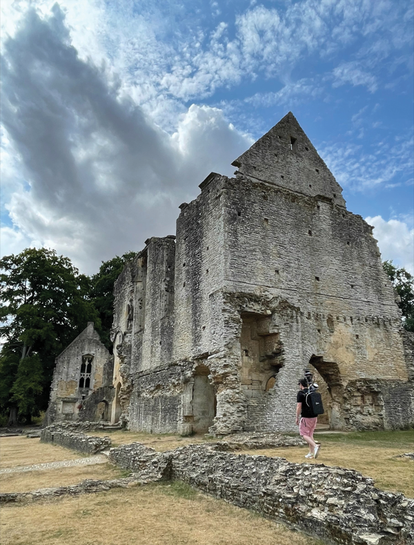
Paris Austin, head of product – New Technology for OxTS, tries out the new backpack at historic Minster Lovell Hall. (Image: OxTS)
More than 400,000 sites in the United Kingdom are on its historical registries. English Heritage site Minster Lovell Hall is located in Oxfordshire, also the home county of inertial navigation company OxTS. The picturesque ruins of Minster Lovell Hall, a 15th-century manor house, include the hall, a tower and a nearby dovecote.
The hall was built in the 1430s by William, Baron of Lovell and Holand — one of the richest men in England. It was later home to Francis, Viscount Lovell, a close ally of Richard III. After changing hands several times, the hall was abandoned and eventually demolished in the 18th century, leaving the extensive remains that stand today.
(Image: OxTS)
The buildings are grouped around a central courtyard in a plan characteristic of a late medieval manor house. For OxTS, the site proved suitable for testing its prototype backpack. The site features dense tree canopies on one side, tight doorways, narrow views of the sky, and plenty of height to test the angled mounting of the survey-focused lidar for when GNSS is denied. Open-sky areas allowed the OxTS team to return to real-time kinematic (RTK) surveying before moving on to another section of the site.
Reconstruction drawing of Minster Lovell Hall as it might have appeared in the 15th century, by artist Alan Sorrell. (Image: English Heritage)
The prototype backpack is based on the OxTS setup for vehicles but was created to enable quick data collection without a car. It is equipped with two Hesai lidar sensors, a new OxTS prototype inertial navigation system and an antenna. The team can connect it to a laptop for configuration and to optimize lever arms and the boresight. Once post-processed with OxTS Georeferencer software, the point cloud below was produced.
OxTS designed the backpack to meet a growing need for localization and georeferencing in both GNSS-denied areas and those that cannot be reached by car, including the construction, environmental, conservation and heritage industries.
RNT Foundation President Dana A. Goward was in London last week for a PNT Leadership Seminar. Here is his report.
In March 2021 the United Kingdom’s government told parliament that a national positioning, navigation, and timing (PNT) strategy was to be published imminently.
Yet, in addition to the normal duties of running the world’s sixth largest economy, the last 20 months have been busy for the UK government: evolving issues with Brexit, more COVID, three prime ministers, Russia’s invasion of Ukraine, financial crises… Small wonder that publishing a strategy to address a “not-right-now” concern hasn’t come to the top of the pile.
Royal Institute of Navigation Leadership Seminar
Yet PNT resilience is an incredibly important issue requiring long-term solutions. As a “learned society,” the Royal Institute of Navigation (RIN) has a duty to bring together professional expertise and educate the public on such important topics.
On Nov. 1, the RIN convened a UK PNT Leadership Seminar with “the UK’s leaders in government, industry, academia and key user communities.” Its goals were to not only highlight the economic benefits of resilient PNT leadership for the UK, but also to “develop a view of approaches, priorities and next steps.”
Attendees expressed a wide variety of concerns. These ranged from difficulties growing and retaining talent in the field, to a lack of understanding among the public and government about the essentiality of PNT to virtually every aspect of modern life.
There was general agreement that establishing a coherent and resilient PNT program in Britain would have dual benefits.
First, it would help protect the nation’s economy and national security. Malicious and natural threats to space-based PNT mean that complementary systems are needed to mitigate outages. A government sponsored study in 2017 estimated losses exceeding £5B during a five-day outage. The study’s authors conceded at the event that longer outages would realize much larger per day losses as infrastructure and systems increasingly suffered.
Action to mitigate disruption of space-based PNT was especially important for the UK, according to the concept paper, because “the sectors where the UK has the most value at risk from a loss of GNSS-provided PNT are precisely the sectors that lack adequate resilient backup options.”
Image: London Economics report
Economic Benefits of Resilience
Secondly, British PNT resilience would also have great positive benefit to the economy, especially if the UK established itself as a leader in the field. A concept paper prepared for the seminar by London Economics found that the value chain for the UK would include research and development, provision of PNT infrastructure, PNT module manufacturing, system integration,and application development.
Among the UK stakeholders most likely to benefit, according to the paper, were companies and institutions that were part of the value chain, along with user communities, government and the public overall.
Attendees and the London Economics concept paper agreed that consistent and focused government leadership was essential. Government must create the conditions and confidence to stimulate the whole ecosystem to deliver resilience and the associated economic benefits. In fact, the paper envisioned the government as an “anchor customer” for resilient PNT providers and device manufacturers. This idea echoed that expressed by representatives of PNT providers in the United States earlier this year. The need for government to protect itself with resilient PNT (thus becoming an anchor customer) was a primary theme during a PNT roundtable held by the U.S. Department of Transportation in August.
Getting Government’s Attention
Finding a way to communicate the importance of PNT and UK government leadership in a way that would generate action was another theme from seminar attendees. One panel member despaired the problem was “Little Susie hasn’t died yet.” It is hard to get government’s attention without a disaster of some sort. Another attendee suggested creating a video to increase public awareness thereby causing government to take notice and act.
Finding a high-profile champion was also discussed. An attendee told a story about a member of the royal family’s interest in quantum technologies, how that led to meetings with government, and establishment of the UK’s £1B quantum tech program. While several indicated this isn’t really a path RIN could use, a combination of personal connections or celebrity with the ability to “tell the story” can be very helpful.
Parliament also Concerned
Just three days after the RIN event, the UK government’s leadership of resilient PNT efforts was also formally criticized by Parliament.
It described PNT services as “key enablers of Critical National Infrastructure (CNI) sectors that underpin our national security and defence interests as well as a wide range of other economic activities…”
After reviewing testimony received by the committee the report made several important findings.
Regarding GPS and Galileo:
“The reliance on foreign systems is concerning due to the potential for the UK to be blocked from using them in the future. Reliance on space-based systems is also not advisable as these can be disrupted through jamming attacks or adverse space weather. The loss of PNT services would be detrimental to the UK, with power distribution, financial transactions, and transport systems all seriously affected, and the UK’s national security put at severe risk.”
Commenting on the UK government’s efforts with OneWeb:
“We are concerned that the Government seems to be progressing towards plans to use OneWeb’s low Earth orbit (LEO) satellite constellation to provide PNT services in the future, despite suggestions from experts that there are many technical issues…”
And the Science and Technology Committee is not alone in Parliament being concerned with the nation’s lack of progress on PNT. In its October 2022 report “Defence Space: through adversity to the stars” the House of Commons Defence Committee said:
“Given the vital need for a resilient PNT network both for defence and for other aspects of critical national infrastructure we are deeply concerned by the complacent attitude towards PNT within government, and by the seemingly low priority which the MOD [Ministry of Defense] attaches to this work. Government must publish the conclusions of the SBPP and should set out a clear timetable for producing and taking forward the UK’s PNT strategy in its response to this report.”
‘Move PNT in Government above the Department Level’
Expressing the utmost frustration, last week’s report from the Science and Technology Committee recommended reassigning responsibility for PNT to a higher level of government than where it is positioned now.
The Department for Business, Energy and Industrial Strategy (BEIS) is the ministry currently responsible for publishing and implementing the long-delayed PNT Strategy.
The committee said that this long delay is evidence the ministry is “…refusing to commit to the critical action that needs to be taken.”
It also said:
“…we believe the responsibility for PNT should lie outside of any one department. The Government should establish the National Security Adviser (NSA) as having overall responsibility for the UK’s access to secure PNT capabilities. The NSA should ensure that the importance of developing secure PNT systems is understood throughout Government and take responsibility for developing a programme and budget for the work that needs to be carried out.”
UK Cross-Government PNT Office
For now, there is no evidence the UK government will adopt Parliament’s recommendation to move responsibility for PNT to the National Security Adviser.
However, BEIS has created a cross-government PNT effort to address the nation’s needs. Attendees at the RIN seminar reported that the team is staffed with representatives from several departments, including the MOD.
Seminar attendees said that PNT is getting to be MOD’s highest space-based priority. While not in a position to lead, Defence was strongly supporting cross-government efforts.
Initiative aims to increase the global coverage, quality and accessibility of seabed mapping data through collaboration and the creation of a more integrated marine geospatial sector
Durdle Door on the beach in Dorset County, United Kingdom. (Photo: Fonrimso/iStock/Getty Images Plus)
The UK Hydrographic Office (UKHO) is inviting UK government organizations involved in seabed mapping who share common interests in optimizing the UK’s national maritime assets to become members of the newly unveiled UK Centre for Seabed Mapping (UK CSM).
UK CSM is administered by the UKHO, and was submitted as a UK Government Voluntary Commitment to the United Nations at the UN Ocean Conference in Lisbon, Portugal, on June 27.
The UK CSM has a remit to increase the coverage, quality and access of seabed mapping data collected using public funds, as well as to better promote it as a critical component of national infrastructure.
Working groups established
Created to spearhead a coordinated approach to the collection, management and access of seabed mapping data – and to champion a more integrated marine geospatial sector in the UK – the UK CSM has established three working groups: National Data Collaboration, International Data Collaboration, and Data Collection Standards.
These working groups will further the discussion and coordination of data accessibility, collection and collaboration, as well as progress work on data standards, by creating the conditions and developing infrastructure to enable the diverse community of marine geospatial stakeholders to come together to deliver significant, sustained and strategic benefits to the UK – particularly in the context of the integrated review and the UK’s Global Britain vision.
So far, 22 government agencies are involved in the inaugural management group meeting of the UK CSM and volunteered to participate on the working groups.
The UK CSM will develop specifications that support UK and international standards for the collection of marine geospatial data.