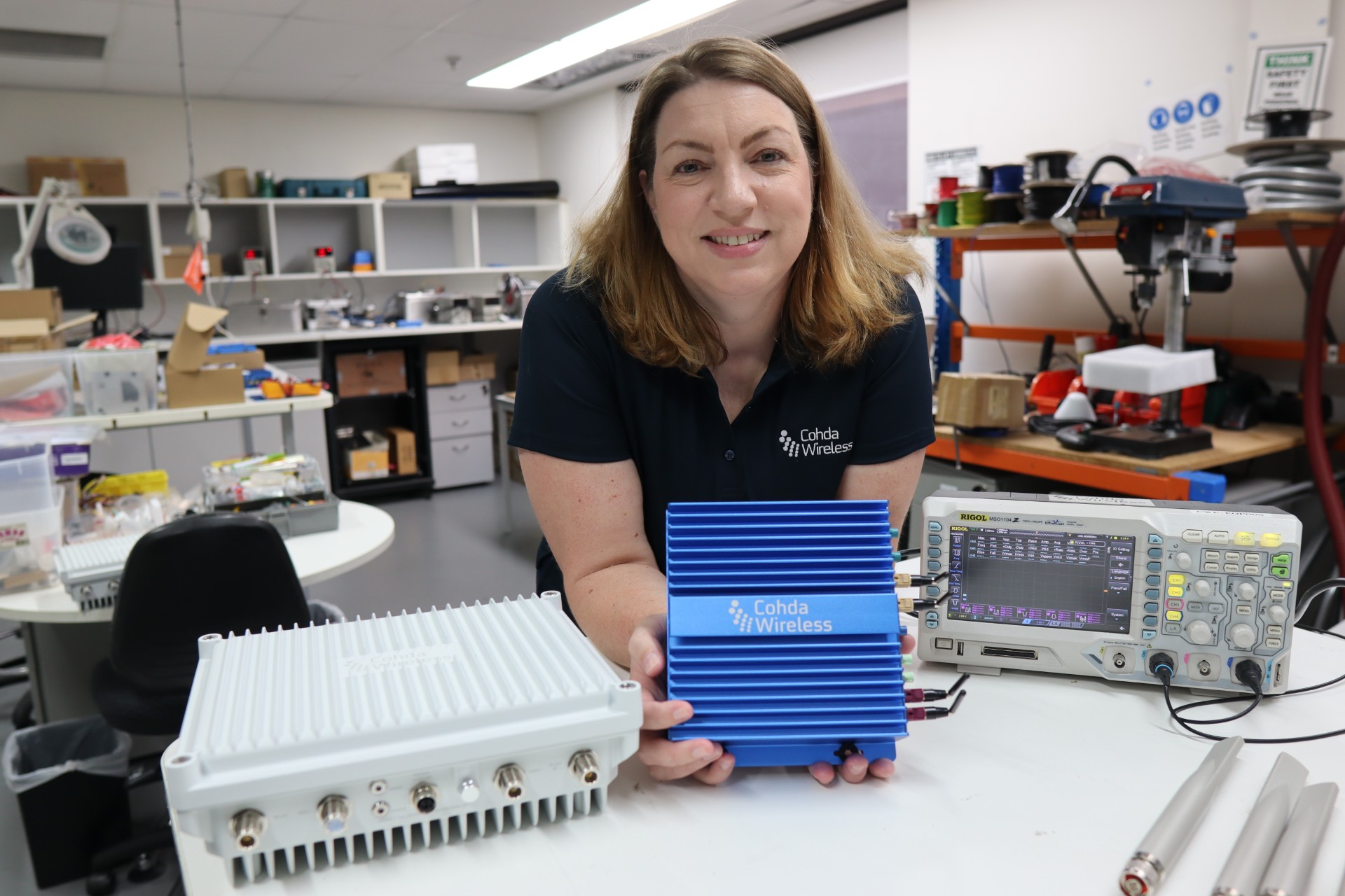
The Maricopa County (Arizona) Department of Transportation (MCDOT) has selected connected-vehicle technology specialist Cohda Wireless to support delivery of its Connected Vehicle Acceleration Zone (CVAZ).
The CVAZ is a USDOT-backed deployment designed to accelerate interoperable vehicle-to-everything (V2X) technology across key corridors in the county. CVAZ forms part of the Federal Highway Administration’s “Saving Lives with Connectivity: Accelerating V2X Deployment” program, which is supporting national models for connected vehicle deployment in Arizona, Texas and Utah.
The Maricopa County project will rely primarily on 5.9 GHz communications and is expected to connect up to 750 physical and virtual roadside units with 400 onboard units across transit, emergency response and freight fleets.
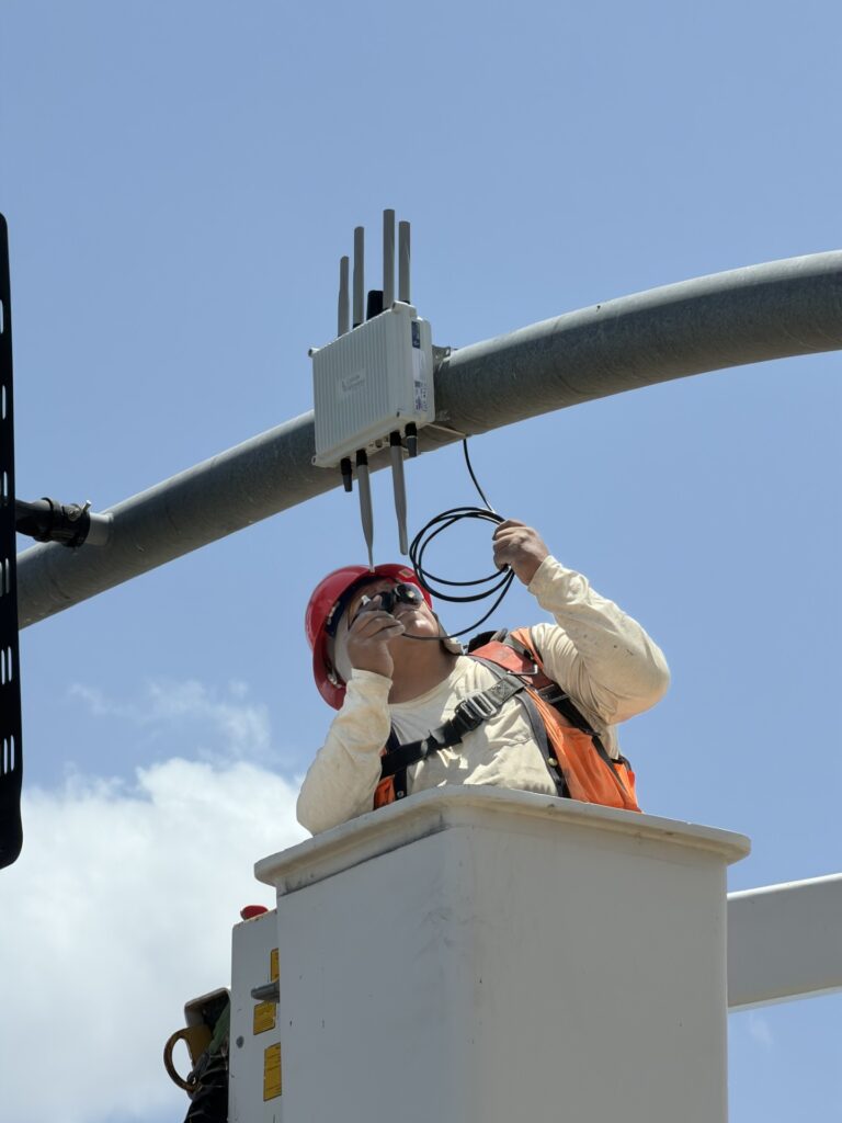
An MK6 Road-Side Unit being mounted to traffic infrastructure. (Credit: Cohda Wireless)
The deployment will support emergency vehicle pre-emption, vulnerable road user alerts, transit signal priority and freight signal priority in Phoenix, Tolleson, Avondale and unincorporated Maricopa County, as well as along ADOT’s US 60 highway.
Together, these applications are intended to help emergency vehicles move more efficiently through intersections, improve transit reliability, reduce freight delays and provide earlier warnings around pedestrians and cyclists.
Following its selection as a vendor, Cohda is contributing technical expertise in testing and deployment planning to support delivery of the CVAZ application zones. Under the project, Cohda will supply MK6 Road-Side Unit (RSU) kits and MK6 On-Board Unit (OBU) kits across the CVAZ application zones.
The program is designed as a multi-vendor deployment. Cohda’s RSU and OBU platforms are positioned to integrate with the county’s selected roadside processing environment, helping reduce integration risk and support faster deployment.
U.S. Department of Transportation (DOT) figures show incidences of GPS signal interference, such as jamming and spoofing, have increased significantly in both North America and much of Western Europe. Both commercial and military operations are affected, and ADS-B reports from Zurich University of Applied Sciences (ZHAW) cite up to 700 global GPS spoofing and jamming incidents taking place daily.
Events are particularly concentrated around war zones, with Lithuanian airspace alone recording more than 300 cases of GPS interference in March. The consequences have ranged from emergency diversions of civilian aircraft to, in at least one case, the downing of an aircraft. Other sectors reliant on precise timing and geolocation, such as communications and emergency services, also are being impacted.
Of course, it’s not just navigation; and a swath of industries rely on PNT signals. This includes secure and regulatory-compliant financial transactions, power grid synchronization, asset tracking, ensuring data integrity and coordinating workloads across global telecommunications and artificial intelligence (AI) servers.
How can PNT systems be made more resilient to this interference? What emerging technologies enable PNT systems to maintain operational capability in GPS/GNSS-denied, degraded or disrupted space operational environments (D3SOE)?
Interference Techniques
GPS interference comes in a wide variety of forms, and systems are susceptible because the signals from the satellites are faint by the time they reach the Earth.
Jamming is a brute force denial of service (DoS) attack, with a device transmitting a signal on the same L1 (1575 MHz), L2 (1227 MHz) or other relevant bands as the PNT satellites. Being nearer and stronger, these signals drown out the GPS information and prevent the ability to calculate a position, simply making GPS services unavailable.
Conversely, spoofing is a more sophisticated technique that mimics the structure of an authentic satellite signal but transmits falsified timing and positioning data. Similar to jamming, this relies on the spoofed signal being closer and more powerful than the legitimate PNT transmission and can either trick the navigation system into believing it is suddenly in a different position, or alter it slowly over time causing, for example, a ship or aircraft to deviate into an unsafe location.
These DoS and deception techniques are the major classes, but in addition to natural and accidental man-made sources, there also are multiple variations on spoofing techniques and methodologies:
Meaconing: Rebroadcasting of an authentic signal with a delay and shift in position to affect navigation systems.
Replay attacks: Like meaconing, but more targeted to financial transactions, fooling GPS-based time-stamping systems into accepting fraudulent transactions.
Data-level manipulation: Where false orbital data, clock corrections and GPS time is given in addition to the location data. These tend to be harder to detect and cause slow changes. They also can be applied to systems that rely on precise timing, such as financial networks and power grids.
PNT Resilience
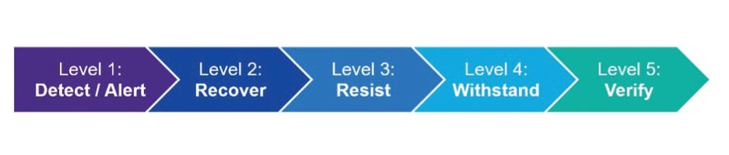
PNT resilience standards are set out in the draft IEEE P1952 standard, which specifies technical requirements and expected behaviors for resilient PNT user equipment.
End users can test five behavior levels, which are defined within this standard to enable users to select a level that is appropriate based on their risk tolerance, budget and application criticality.
Photo: PNT Resilience Levels
Level 1 represents a basic ability to detect interference such as jamming, spoofing, or other disruptions, and alert users. Level 2 enables equipment to automatically recover to normal operation when the disruption is no longer present. In level 3, the equipment can maintain acceptable performance during the disruption. This capability is fortified in level 4 by leveraging multiple diverse sources or advanced mitigation techniques. Finally, level 5 enables the equipment to verify that the time or PNT information received is accurate.
Here in the U.S., the NIST 8323.1 Cybersecurity Framework for PNT also offers a comprehensive approach to assessing and mitigating PNT-specific cybersecurity risks. The DHS’ Resilient PNT Conformance Framework and CISA Federal PNT Services Acquisition Guidance are additionally important.
Countering Jamming
Traditional PNT systems are struggling to keep pace and meeting IEEE P1952 to tackle GPS interference requires a sophisticated, multi-source zero-trust architecture that never trusts, always verifies and authenticates, and goes beyond simple signal reception. For mission-critical systems, not only do threats need to be detected, but incoming data need to be validated and alternative sources for PNT incorporated, all within an intelligent sensor fusion system.
If we look first at the DoS jamming technique, here the issue is an inability to detect the medium-Earth orbit (MEO) GPS/GNSS signal in the presence of another more powerful signal.
It is possible, however, to reinforce L-band communications from GPS satellites, and look to stronger signals, notably from low-Earth orbit (LEO) satellites. While these have less accuracy for timing (GPS/GNSS: <15 ns vs 80 ns for LEO), they are significantly stronger (the Iridium LEO STL signal is 1000x stronger than GNSS) and are more resistant to jamming.
Countering Spoofing
In spoofing, the use of encrypted signals is vital.
GPS signals are open, unencrypted and should not be trusted blindly, and the use of alternative cryptographically secured alternatives is essential to ensure the signal’s origin is legitimate. For example, this is implemented on both the Inmarsat GEO and Iridium LEO satellites used in VIAVI’s SecurePNT and SecureTime services.
Sensor fusion also should be implemented to combine PNT data with information coming from onboard sensors such as inertial measurement units (IMUs) to identify inconsistencies — not just sudden large jumps but continual slight deviations.
Beyond these, navigation message authentication can be implemented, using a public key to verify the satellite-broadcast signature and prove the location, clock corrections and status being transmitted. This is already implemented by Europe’s Galileo Open Service Navigation Message Authentication (OSNMA) and makes it very difficult to data-level spoof these satellites.
While using receiver autonomous integrity monitoring (RAIM) techniques, calculate position with redundant satellites, excluding one satellite each time to check for consistency of results. ARAIM (advanced RAIM) uses the same technique, but applies it to multiple constellations, for example, GPS and Galileo.
Signal liveliness/consistency checks can be particularly effective against meaconing and replay attacks. These techniques examine the Doppler shift of the signal, with satellites having predictable and specific profiles that will differ significantly when compared to a ground-transmitted signal, which will have a near-zero Doppler shift.
Operating Under D3SOE
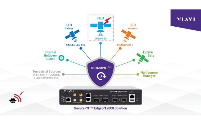
The above is a summary of the types of techniques that underpin VIAVI’s SecurePNT and SecureTime services.
SecureTime eGNSS GEO uses an encrypted L-band signal, transmitted from Inmarsat’s GEO satellites to create an enhanced timing service with GNSS authentication and anti-spoofing capabilities and provides sub-5 ns timing accuracy when installed on SecurePNT products.
Conversely, the SecurePNT systems implement multi-source receivers for GNSS backup and multi-band GNSS with GEO-L for outdoor antennas. The PTP grandmaster uses the latest sub-microsecond accuracy PTP protocol and the traditional millisecond range accuracy Network Time Protocol (NTP) to be compatible with virtually all standard IT equipment — also implementing high-speed 25G PTP Ethernet for connection to high-performance AI data center and AI-RAN networks and financial exchanges without creating bottlenecks.
Terrestrial sources, such as a network PTP feed and an optional atomic caesium clock, also can be used for synchronization to increase resilience in the event of a prolonged GPS outage. Nino De Falcis is an experienced business development leader with a strong background in the Global PNT market. Currently serving as the senior director of Global PNT Business Development at VIAVI Solutions since January 2024, he focuses on accelerating global business development and identifying growth opportunities.
Iridium Communications is working with T-Mobile to on a broad network deployment of positioning, navigation and timing (PNT) services, starting with live-site activations across the United States. The deployments will deliver 5G network complementary timing synchronization to strengthen the cellular network’s resilience and help ensure reliability for customers.
The U.S. Department of Transportation CPNT Action Plan is designed to evaluate mature and commercially available CPNT technologies to strengthen PNT resilience and enhance the safety of critical infrastructure, like 5G networks. DOT is the U.S. government’s civil lead for PNT.
Under the contract, T-Mobile will expand its installation of Iridium PNT receivers to 90 additional live 5G network sites in geographically diverse locations. Iridium PNT will help protect against GPS disruptions that cause downtime and compromise the data integrity and performance of 5G networks, which rely on coordinated, precise timing to deliver the necessary speed, capacity and reliability of service to end-users.
T-Mobile will also perform nominal and adverse user equipment exercises at its indoor testing range. It has the necessary wireless infrastructure for DOT, Iridium, and T-Mobile to observe and record results.
Capable of sub-100-nanosecond accuracy — better than a millionth of a second — and secured using cryptographic techniques, Iridium PNT signals are 1,000 times stronger than GNSS systems like GPS and work inside buildings with no need for an outdoor antenna. The service is delivered by Iridium’s low-Earth orbit (LEO) satellite constellation, which provides global weather-resilient L-band connectivity.
Speakers include Diana Furchtgott-Roth Deputy Assistant Secretary for Research and Technology; ship captains from Maersk Lines; and representatives from the National Security Council, the Maritime Administration and U.S. Coast Guard.
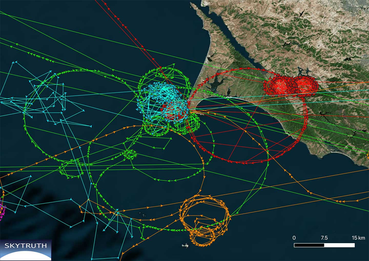
While GPS jamming and spoofing is a problem in many transportation and critical infrastructure sectors, it is often most visible in maritime. This is because the Automatic Identification System (AIS) used for collision avoidance and traffic management for major vessels transmits location data based on GPS inputs.
These transmissions are received by coastal networks and satellite systems. AIS data is often freely available to the public or easily accessed.
Ships in Russian waters being spoofed to inland airports, vessels in Chinese ports reporting they are inland and circling government buildings, and ships in one part of the world transmitting their location as thousands of miles away and circling in the ocean off northern California are three of the highest provide examples in recent years.
In 2019, the U.S. Coast Guard brought interference with GPS signals as an “urgent issue” to the International Maritime Organization.
In February, President Trump issued an Executive Order on responsible use of positioning, navigation and timing. This workshop is part of the federal government’s efforts, as a part of the order, to educate the public about vulnerabilities associated with over-reliance on GPA.
The U.S. Department of Transportation (DOT) announced competitive grant solicitation for a new University Transportation Center (UTC) specifically on Highly Automated Transportation Research.
Photo: Resilient PNT Foundation
“People will not be comfortable getting into an automated vehicle or with platooning driverless trucks heading down the highway if they think… their GPS might be spoofed,” according to Diana Furchtgott-Roth, Deputy Assistant Secretary at the U.S. Department of Transportation at a recent presentation. She believes getting robust and resilient navigation right is a prerequisite for success with automated and autonomous systems.
As part of this effort, her office is looking for a U.S. non-profit institution of higher learning to become a University Transportation Center (UTC) focusing on “Highly Automated Transportation Research.” A critical component of this new center’s efforts will be work on resilient positioning, navigation and timing (PNT) services.
From the abstract:
“Progress on the path toward integrating automated systems into the transportation domain for all modes of transportation (surface, aviation, and maritime) will be aided by additional research addressing challenges associated with ensuring resilient Positioning, Navigation, and Timing (PNT) services to support automated systems.
“This University Transportation Center will complement the new Center of Excellence for Highly Automated Transportation Systems being implemented within the USDOT. Among the critical needs is research to support securing cyber resilient PNT receivers for use in automated systems. This UTC will carry out research to support the development of standards and or prototypes and incorporate existing U.S. Government guidance.“
The department is also looking for UTCs for Communications Technology and E-Commerce Effects on Travel Demand; Implications of Accessible Automated Vehicles and Mobility Services for People with Disabilities; and Strategic Implications of Changing Public Transportation Travel Trends.
According to a press release issued March 30, one institution will be selected in each of the four areas. The total initial funding available to is just shy of $5 million.
Through the Notice of Funding Opportunity, DOT intends to fund one UTC in each of the following specific topic areas:
Highly automated transportation systems research
Communications technology and e-commerce effects on travel demand
Implications of accessible automated vehicles and mobility services for people with disabilities
Strategic implications of changing public transportation travel trends.
Only U.S. non-profit institutions of higher education are eligible to apply or to be members of a proposed UTC consortium. Non-profit institutions of higher education may include qualifying two-year institutions.
“Our University Transportation Centers are not only the seeds of our future transportation system, they serve as living labs, bringing research to reality. Four new UTCs will address a variety of important 21st century transportation topics,” said Deputy Assistant Secretary Diana Furchtgott-Roth.
Thee Tier 1 UTCs will support research needs that DOT has identified under two of the FAST Act research priorities (49 U.S.C. § 6503(c)(1)): “Promoting Safety” and “Improving Mobility of People and Goods.”
The Notice of Funding Opportunity (NOFO) is available now. For more information on the UTC program, contact Nancy Wilochka, (202) 366-5128.
U.S. National PNT Architecture from a 2007 Department of Transportation report, updated in 2017. (Graphic: U.S. Department of Transportation)
The U.S. Department of Transportation (DOT) says it will implement a terrestrial timing system to complement and back up GPS signals, and plans to demonstrate the new system “toward the end of the calendar year.”
The demo is anticipated to include a range of technologies, including among others local positioning systems such as Locata and NextNav, wide-area coverage by eLoran, and — though the parameters of DOT’s mandate specified terrestrial backup — space-based signals furnished by Satelles.
The statement came in response to an inquiry in March from the House of Representatives’ Transportation and Infrastructure Committee concerning progress on a GPS Backup Technology Demonstration that was mandated in December 2017. Although funds were appropriated for the project, committee chair Peter DeFazio of Oregon saw little to no evidence of work being done, and so required a status report.
DOT issued a Request for Information (RFI) on May 3, with a due date of June 3. The RFI asked for “readiness-level six” technologies (bearing demonstrated results in a relevant environment) “capable of providing backup positioning, navigation, and/or timing services to critical infrastructure in the event of a temporary disruption to GPS.
“This demonstration effort also is expected to encompass technologies capable of providing complementary PNT functions to GPS by either expanding PNT capabilities, including cross checks, or extending them to GPS or Global Navigation Satellite System (GNSS)-denied or degraded user environments.”
The DOT said it is “interested in leveraging PNT service technology initiatives.” Possibly, the agency intends to contract for a service rather than build a new system.
Congress first required DOT to establish an operational terrestrial timing system to back up GPS signals, then expanded that definition to include positioning and navigation services.
Systems or services, or combinations thereof, must now provide all three functions.
The U.S. Department of Transportation (USDOT) convened leaders from state departments of transportation, stakeholders in academia, and representatives from the auto industry in Washington, D.C., to discuss the importance of preserving the 5.9 GHz spectrum for transportation safety.
The 5.9 GHz band supports vehicle-to-everything (V2X), a wireless technology that enables data exchanges between a vehicle and its surroundings. Starting with advanced technology development and demonstrations about 20 years ago, America has deployed 54 operational V2X projects, improving safety today, with more in the pipeline.
Vehicle manufacturers are planning to equip new cars with the technology. This next generation of intelligent transportation communications promises to improve safety for drivers and for vulnerable roadway users, such as pedestrians, bicyclists, disabled persons and transit users.
The National Highway Traffic Safety Administration (NHTSA) estimates that full adoption of just two V2X safety applications would prevent about half a million crashes and save approximately 1,000 lives a year. As more safety applications are developed for vehicles, more lives could be saved.
V2X will also support an efficient, safe, and smooth transportation system, with vehicles communicating with traffic lights to improve the flow of traffic. V2X applications such as dynamic traffic signal control and prioritization have the potential to reduce travel times by up to 27% and reduce fuel emissions.
Link to video of CV2X demonstration in Hawaii in June. (Photo: USDOT)
U.S. Secretary of Transportation Elaine Chao has launched an initiative to safely test and validate advanced drone operations in partnership with state and local governments in select jurisdictions.
Prospective local government participants are asked to partner with the private sector to develop pilot proposals. After evaluating all of the applications, USDOT will invite a minimum of five partnerships.
The department also will publish a Federal Register Notice with more details about how applications will be evaluated and how the program will work.
More about the program is available on the DOT website.
The program will help tackle the most significant challenges in integrating drones into the national airspace while reducing risks to public safety and security, USDOT said. The program is designed to provide regulatory certainty and stability to local governments and communities, UAS owners and operators who are accepted into the program.
In less than a decade, the potential economic benefit of integrated unmanned aerial systems into the nation’s airspace is estimated to equal up to $82 billion and create up to 100,000 jobs, according to an economic report by the Association for Unmanned Vehicle Systems International (AUVSI).
The program will help the USDOT and Federal Aviation Administration (FAA) develop a regulatory framework to:
allow more complex low-altitude operations;
identify ways to balance local and national interests;
improve communications with local, state and tribal jurisdictions;
address security and privacy risks; and
accelerate the approval of operations that currently require special authorizations.
“This program supports the president’s commitment to foster technological innovation that will be a catalyst for ideas that have the potential to change our day-to-day lives,” Chao said. “Drones are proving to be especially valuable in emergency situations, including assessing damage from natural disasters such as the recent hurricanes and the wildfires in California.”
The pilot program will evaluate a variety of operational concepts, including night operations, flights over people, flights beyond the pilot’s line of sight, package delivery, detect-and-avoid technologies, counter-UAS security operations, and the reliability and security of data links between pilot and aircraft.
Industries that could see immediate opportunities from the program include commerce, photography, emergency management, precision agriculture and infrastructure inspections and monitoring.
“Stakeholders will have the opportunity through this program to demonstrate how their innovative technological and operational solutions can address complex unmanned aircraft integration challenges,” said FAA Administrator Michael Huerta. “At the same time, the program recognizes the importance of community participation in meaningful discussions about balancing local and national interests related to integrating unmanned aircraft.”