GPS World Editor-in-Chief Matteo Luccio sat down with Anthony McClaren, product marketing manager of geospatial technologies at Trimble, to discuss Trimble’s new R980 GNSS receiver and its implications for the geospatial surveying industry.
What’s your position?
I am on the Trimble Geospatial Go to Market team. Product marketing managers are more customer-facing, while product managers are more engineering-facing. I’m based in Melbourne, Victoria, Australia, and I’ve worked at Trimble for almost two years, but I worked with Trimble equipment for 16 years before that for a dealership and for almost 20 years in the geospatial surveying industry. The rest of my team is based in our Westminster head office.
What’s new about Trimble’s R980? What markets does it target?
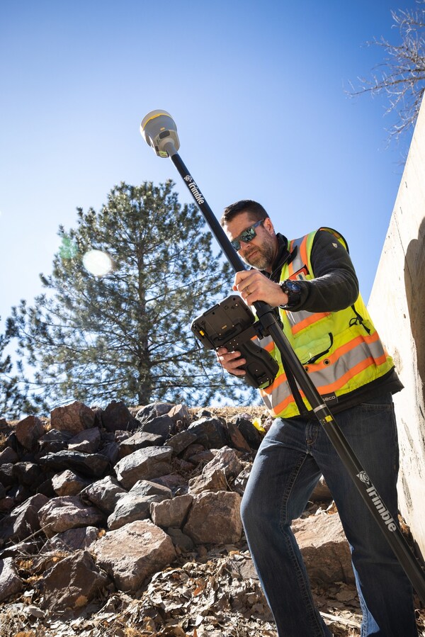
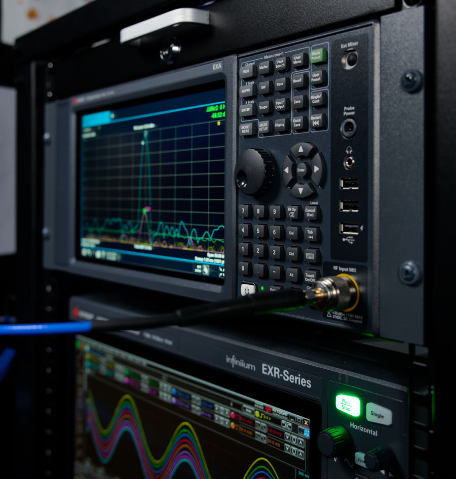
The Trimble R980 takes over from the R12i GNSS system as the flagship product in the Trimble GNSS receiver portfolio. New features include a communications update. The R12i had only a 450 MHz radio. The R980 also has a 900 MHz radio. That’s very beneficial for people who find themselves on large-scale construction sites where they use 900 MHz radios, particularly in North America. These radios are much easier to license than 450 MHz radios, which outweighs the disadvantage of having a shorter range.
The R980 can be used as either a base station or a rover, correct?
Yes. The R12i had a 3.5G modem. The R980 has a 4G LTE cellular modem. So, it’s a global cell modem and the 4G network across the globe is far more expansive than 3G or 5G. 4G LTE also offers enough data downloading for things like VRS and Trimble’s Internet Base Station Service (IBSS), a new feature in Trimble Access software that the R980 is also capable of using. IBSS is a user’s Network Transport of RTCM via Internet Protocol (NTRIP).
So, you have a base station with a SIM card in the receiver. You start your base station as normal, and data is streamed to a Trimble data center. Then, you take your Rover, as we do today with a VRS survey. It has a SIM card, either in the receiver or in the controller, and you can connect directly to your base station via the Internet and stream your own corrections.
It is particularly useful if you’re not in a VRS environment or if you want to get the range of using a cellular network instead of radio. It also means that you don’t have to consider where you’re going to put your repeater, such as on the top of a hill. You don’t have to worry about these sorts of things anymore, because we’re using the Internet to stream out corrections rather than a radio.
You’re also uploading data to the office in real time.
That’s handled separately, via Trimble Connect on your data collector. It’s transferring data directly to a project.
This is your top-of-the-line, survey-grade receiver, right?
Absolutely.
In terms of cost and other considerations, for what other applications is it practical?
We’re seeing a lot of our topline receivers being used in civil construction, transportation, infrastructure projects, and mining — because the Trimble receivers are tracking all the currently available satellite signals. It means that surveyors working in an open-cut mine can be at the bottom of the pit and still achieve survey-grade results because they’re tracking so many satellites. It is also used by the more traditional, everyday land surveyors who are out there walking the streets, because the R980 with Trimble ProPoint GNSS technology allows our users to measure in the most rugged GNSS environments, such as urban canyons.
Speaking of walking down the street, the R980 is for either static deployment or slow-moving platforms, not for vehicles, right?
Correct. The mobile mappers that we see on vehicles have very high-end inertial measurement units (IMUs) to provide heading, pitch and roll and use lidar or laser scanning to take the measurements. The R980 has an IMU to enable very accurate tilt compensation up to at least 30°.
Looking at the broader trends in the industry, how do you see requirements changing? Of course, it depends on the market…
One thing that doesn’t depend on the market — I have learned this since joining Trimble — is that globally a lot of the industry is facing the same issue, which is a massive shortage of surveyors to meet the demand for them. In Australia alone, I think we’re short about 2,400 surveyors for next year. So, it’s quite a significant number. Our customers on the ground are being asked to do a lot more with a lot less.
So, Trimble’s goal with our products — whether it’s our top-of-the-line GNSS, total stations or something more entry level — is giving our customers the most productive equipment that we can so that they can do their jobs as quickly and efficiently as possible. That’s why we have such things as Trimble Connect.
So, it’s not just about single point measurement anymore. It’s about using the ecosystem to be as efficient as possible. Once I’ve taken a measurement, what am I going to do with it? Beyond that, it’s in my data collector, which is using Trimble Connect to sync to the office, where I have Trimble Business Center software. So, the surveyors and the draftspeople at the office can start work on that straightaway and keep the guy in the field working.
Concern keeps growing about spoofing and jamming, mostly for defense and life-critical applications. How do you see that affecting some of your civilian markets?
Currently, in civilian applications, most of the jamming that we’re seeing is ad hoc and unintentional, not nefarious. For example, a truck driver who uses a consumer-grade jammer plugged into his 12-volt outlet so that his boss can’t track him. It’s unpredictable. I’ve also seen banks transmitting their data back to the head office near an antenna for a CORS site and jamming it.
Trimble receivers have anti-spoofing and anti-jamming solutions. They deal with spoofing in a multi-layered way. Number one is rejection of spoof signals in the digital signal processing. Essentially, that means that a spoofed signal generally comes through with a higher correlation peak, because the transmitter is probably closer than a satellite 20,000 km away, so the receiver can isolate that signal and reject it from the positioning algorithm. Also, when it comes to spoofing and jamming, it tends to be a particular constellation and not a particular satellite. So, if you’re experiencing jamming or spoofing generally, it’s going to be all the GPS or Galileo constellation — not, say, satellite 32.
Our survey-grade receivers use the Maxwell 7 technology, which can also cross-check orbital data from multiple sources. So, it’s detecting the orbital parameters transmitted by each satellite, and it can then check if any of those have changed unexpectedly, or if they fall outside of reasonable bounds, and exclude them.
Are you utilizing any non-GNSS PNT sources, such as signals from LEO satellites?
Not today. Is there a place for them in the future? Absolutely. Is Trimble aware of such things as Xona low-Earth orbit (LEO) satellites? Yes. Obviously, we would love to be using those, when they’re ready and when we have products ready.
What about AI?
AI is an interesting one. That’s obviously a hot topic, isn’t it? Today, we don’t necessarily use AI. When it comes to such products as the R980, we use mixed reality — where you have data overlaid by the camera in your controller and using your receiver and turning around, you can see your digital environment as well as your physical environment — but we are not using AI as such today. We overlay CAD data on what is physical, and it’s still three-dimensional. So, regardless of whether I turn this way or that, I can see my design in the real world.
Locus Lock has partnered with Xona Space Systems to develop a GNSS receiver that uses Xona’s multi-frequency PULSAR service. Locus Lock aims to provide a robust software-defined GNSS receiver for commercial and military applications.
According to the company, Xona’s PULSAR service will be delivered via a constellation of low-Earth orbit (LEO) satellites, which orbit the Earth approximately 20 times closer than traditional GNSS satellites. This proximity allows PULSAR to offer higher signal power and a modernized signal design to offer improved multipath mitigation, higher accuracy and increased protection against radio frequency interference and spoofing compared to current GNSS systems.
The technology is suitable for various applications, including vehicles navigating dense urban areas, agriculture and construction, UAVs, high-speed aircraft and defense applications. Locus Lock’s GNSS software stack can be deployed on existing customer computational infrastructure, ranging from small embedded devices to larger centralized computers. This flexibility allows for adaptation and configuration of the software to suit specific deployed environments.
The system features inertially aided carrier-phase differential GNSS (CDGNSS) for maintaining precision in challenging ecosystems, advanced interference mitigation and detection technology to ensure authentic GNSS signals are received, and the dual-antenna, triple-frequency RadioLion RF front-end for capturing raw GNSS signals. These features offer signal situational awareness, anti-spoofing, and interference mitigation.
Spirent has implemented Xona Space Systems’ PULSAR production signals for seamless integration into the existing SimXona product line. The PULSAR X1 production signal implementation has passed a diligent Xona certification and the PULSAR X5 signal verification process is currently underway. It is expected to pass certification during the summer of 2024. Spirent is now accepting orders for SimXona with production signals capability.
Xona is developing PULSAR, a high-performance positioning, navigation and timing (PNT) service built on a backbone of low-Earth orbit (LEO) small satellites. Xona’s smallsat signals will improve PNT resilience and accuracy by augmenting GNSS while operating with an independent navigation and timing system architecture. Xona is fully funded to launch its production class satellite, the In-Orbit Validation mission, in 2025.
Spirent is the leading provider of PNT test solutions and recently launched a sixth-generation simulation system, PNT X. Designed for navigation warfare (NAVWAR) testing, PNT X is an all-in-one solution with a native implementation of SimXona.
Aerospacelab and Xona Space Systems have entered a strategic partnership to integrate Xona Space Systems’ positioning, navigation and timing (PNT) technology into Aerospacelab’s satellite platforms.
Under the partnership, Aerospacelab will use its Versatile Satellite Platform (VSP) for the design, manufactureand launch of Xona Space Systems’ first navigation satellite equipped with its PNT payload.
Xona is developing a commercial PNT service through a constellation of low-Earth orbit (LEO) satellites. The company plans to offer the service as a backup to PNT provided by GPS.
The collaboration aims to use Aerospacelab’s capabilities in small satellite design, manufacturing and operations alongside Xona’s specialized knowledge in PNT payloads to provide enhanced navigation solutions that address current and future needs in satellite navigation and applications.
GPS World Editor-in-Chief, Matteo Luccio, met for an exclusive interview about Spirent Communications collaboration with Xona Space System‘s PULSAR, new releases, and more with Adam Price, Vice President – PNT Simulation, Spirent Communications.
Spirent has concluded a review of Xona Space Systems’ PULSAR production signals, and has deemed them feasibile for integration into the SimXona product line. Spirent will integrate the Xona production signals as an evolution of the SimXona platform.
Support will become available to existing and new users throughout 2024.
Xona is developing PULSAR, a high-performance positioning, navigation, and timing (PNT) service built on low-Earth orbit (LEO) small satellites. Xona’s high-powered smallsat signals aim to improve PNT resilience and accuracy by augmenting GNSS while operating with an independent navigation and timing system architecture.
An exclusive interview with Mark Holbrow, VP of Product Development, Spirent Communications and Roger Hart, Sr. Director of Engineering, Spirent Federal Systems. For more exclusive interviews from this cover story, click here.
What are your roles?
MH: Our business is based in the UK. I am responsible for the vision and direction of the Technology portfolio required by Spirent’s Positioning Technology business unit.
RH: I am responsible for the U.S. add-on components to the simulator, the restricted signals, and support for the U.S. government labs and contractors.
How have the need for simulation or the requirements for it changed in the past five years, with the completion of the BeiDou and Galileo GNSS constellations, the rise in jamming and spoofing threats, the sharp increase in corrections services, and the advent of new LEO-based PNT services?
MH: I would say that the need for thorough and comprehensive testing has never been greater. That need is being driven on multiple fronts due to the understandable pressure on PNT systems needing to deliver enhanced accuracy, reliability and resilience, in the presence of emerging threat vectors and an expanding application space that’s utilizing ever more complex combinations of new and enhanced signals and sensors of opportunity. Underpinning Spirent’s leadership in ensuring the test needs for this evolving, challenging and increasingly diverse market are its team, its technology and its partners. That team is well-established, dedicated and highly experienced — their sole focus is designing, manufacturing and supporting PNT test solutions. The technology focuses around our pioneering dedicated SDR hardware platform and software simulation engine, which allied provide performance, scalability and flexibility, within an open accessible architecture. In addition, close collaboration with our selected partners ensures the opportunity to support and integrate new and emerging PNT technologies through their tools, applications and hardware.
You mention the advent of LEO. A key reason why Spirent was first to market and successfully supported an early LEO + GNSS receiver test-bed (through close and collaboration with Xona and NovAtel) was driven by team, technology and partners.
Two other important areas that have definitely continued to grow and evolve in importance and priority have to be increased realism and test automation. Both are areas in which Spirent continues to prioritize and invest R&D dollars.
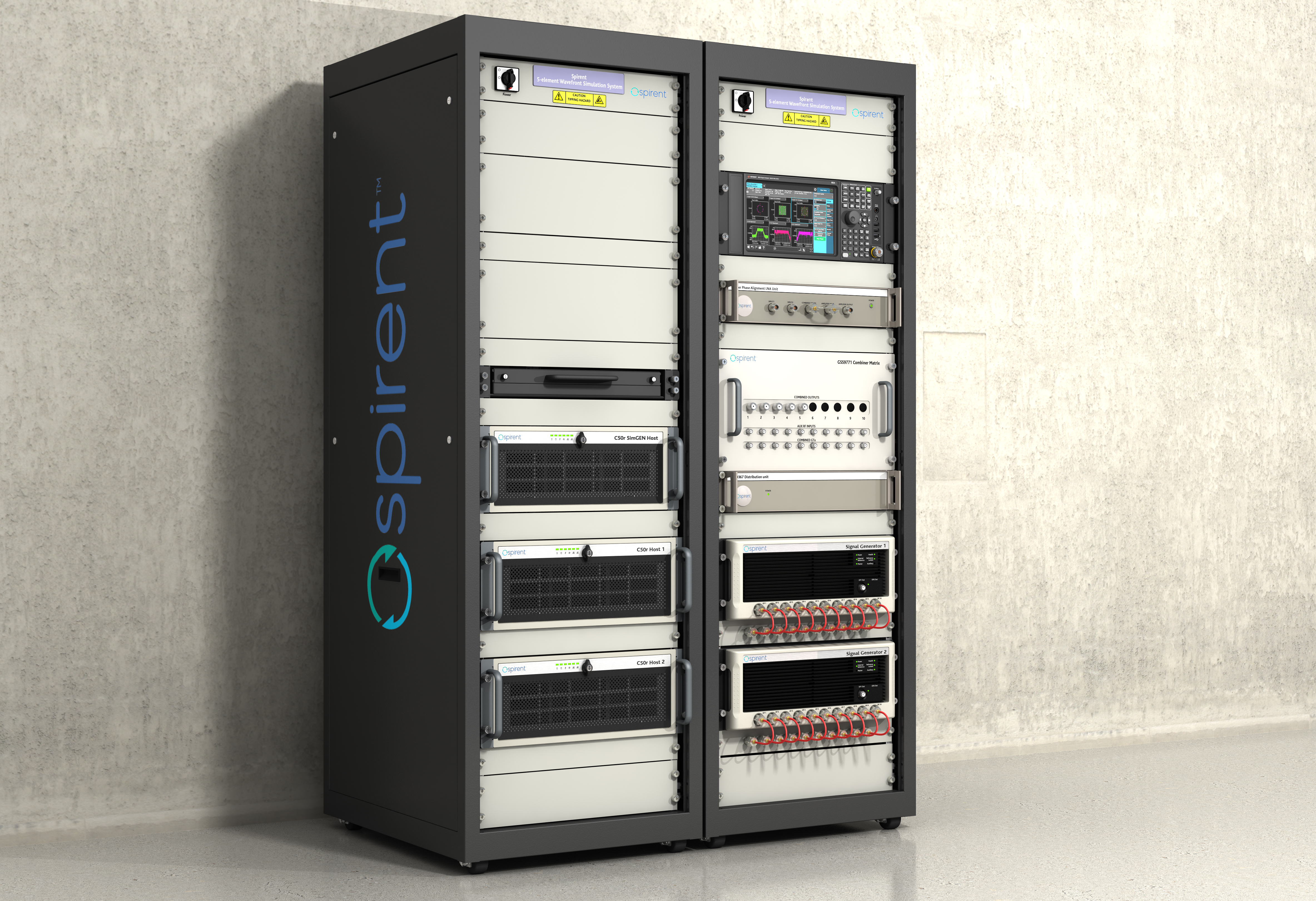
Spirent’s integrated, software-defined wavefront simulation system for a 5-element controlled reception pattern antenna (CRPA). Spirent solutions support 16+ antenna elements. (Image: Spirent)
With all these additional signals, is it still a single simulator or do you have to somehow split it up into different modules?
MH: Good point. Again, a key element with the Spirent solution is that it is very scaleabale and flexible. Spirent has a generic SDR that can be re-purposed to simulate whatever signals are required. That way, we can compile different signals from either one radio or multiple radios coming from the same system. Together with being able to bring in multiple chassis to gradually grow the simulation solution, while also maintaining for each of those signals the fidelity, channel count, and accuracy that customers demand.
Including every signal currently available?
MH: Absolutely, sir. In fact, signals that are still on the drawing board as well. We can enable the user with effectively an arbitrary waveform simulator or ‘sandbox’ to experiment with different modulation schemes, different chipping rates, codes, bandwidths and navigation data content. So, in addition to using that architecture to generate the signals, we allow customers to experiment with it themselves. That’s certainly accelerated over these last five years, and there’s no sign of it stopping. We’re currently working with customers and partners all over the globe who are developing both brand new and emerging PNT systems, whilst also providing all the vital simulation tools to aid the R&D of existing and planned SIS evolutions.
RH: The increasing number of signals that we can support multiplies the permutations and combinations of test cases that users can do. There is a lot of emphasis also on the user interface side of things, so that from one interface you can also easily control all these interfaces with third-party tools, because proliferation of signals produces a huge possible test volume.
What are the specific challenges in realistically simulating new LEO-based signals and any new services being developed for which you don’t have any live sky signals to record yet, only ICDs and other documents?
MH: Again, great question. The key reason Spirent excels in this arena is that the core simulation engine and SDR are agnostic of the constellation and signal type that’s being generated. So, the underlying principles of accuracy, range rate, pseudo-range control, and delay, together with the RF fidelity from Spirent’s SDR+ Sim engine, can be readily manipulated to simulate the wealth of emerging signals, including LEO.
The other area that becomes very important is that if we do not have sight of the ICD, we can enable customers to use our tools to readily populate elements of that ICD themselves. That way, the best of both worlds is achieved, i.e. a turnkey SIS solution, or we can just enable the customer to do it themselves.
Are accuracy requirements or any other requirements for simulation increasing to enable emerging applications?
MH: They are. Both current and emerging test needs are continuing to drive the need for enhanced simulation realism. Always a tough nut to crack, but our hard-won experience and expertise, allied with continuing adoption of latest-generation technology, is allowing us to take some significant strides forward. Real-world testing has an incredibly important role to play and that’s why at Spirent we continue to invest in and develop the GSS6450 Record & Playback System (RPS). However, we are also on that quest for the ‘Holy Grail’ that has all the well understood and necessary advantages of lab-based testing but with the simulation environment being as true to the real world as possible.
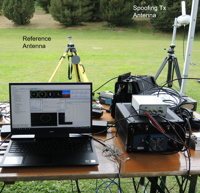
A German Armed Forces test center, WTD-61, recently used Spirent’s new Field Simulator to conclusively demonstrate the susceptibility of some UAS to spoofing. (Image: Spirent)
A further area where both current and emerging test needs are demanding more and more from the test environment is resilience testing. Spirent now supports a multitude of vulnerability and corresponding mitigation/prevention test cases. Those test cases become increasingly complex as multiple combinations of the threat/mitigation surface evolve — including jamming, spoofing, cyber-attack and CRPA.
Many of these test cases are driving the state of the art and, especially in the case of CRPA testing, Spirent’s purpose-designed SDR comes into its own. Technology bakeoffs and corresponding customer adoption have shown that only through the use of that dedicated purpose-built technology, the simulator test bed can deliver the necessary carrier and code phase stability, very low levels of uncorrelated noise across antenna elements and high J/S that is demanded.
Again, with respect to flexibility, we also support ways to let customers generate their own IQ data. That data can be streamed into the Spirent simulator and combined sympathetically and coherently with the signals generated inside the platform. So, you can layer new signals on existing ones, or introduce a completely new dedicated IQ stream.Finally, hardware-in-the -loop (HIL) testing requirements continue to be a crucial aspect in test coverage. Whether that application is automotive, projectiles or autonomous vehicles, the need for lower latency and higher 6DOF sampling to capture as many trajectory nuances as possible continues to grow. Spirent’s 2KHz system achieves very high iteration rates (SIR) and <2msec latency.
What are the key differences between your simulators for use in the lab and those for use in the field? I assume that the latter are lighter, smaller, and less power hungry. Do they use modules so that users can pick the ones they need for a particular test?
MH: We do support in-the-field test use cases. Spirent has record-and-replay (RPS) systems to take soundings in a wide-band RF environment, record them, then bring them back into the lab for replay. They are sized to fit into a backpack, battery-powered, accessible, and easy to use.
Recently, we have also taken some of our signal generator IP and been able to create a smaller form factor portable simulator for outside use. Its footprint is considerably smaller than that of one of our lab-based simulators. It’s primarily a mechanism for testing the resilience in the field of devices under test. Armed with a Spirent simulator and the appropriate transmit licenses, a customer can put their DUT through an array of vulnerability test cases in a live real-world environment.
You mentioned licenses. As far as jamming, specifically, and maybe spoofing, I presume that you’ll need a license for a specific time and place and that you will have to be far away from, say, an airport.
Absolutely. Right. The details will vary depending on the jurisdiction, but you will need a license to transmit. And, as you rightly say, often those places will be very remote so as not to interfere with the public. We’ve had instances where we’ll work with a customer who has those appropriate licenses and then we can provide this equipment for them to be able to put it through a battery of tests.
You generate the spoofing in your simulator, of course. Do you also generate the jamming inside the same box or from a separate jammer nearby?
It could be either. We can use our simulators to generate internally wide range of interference signals supporting a wide bandwidth, high max o/p power and large dynamic range. This is especially important in instances of CRPA testing, in which it is vital to accurately reproducing a jamming wavefront commensurate with the arrival angle and delay incident at each antenna element. Correspondingly, we support turn-key solutions to connect, control and integrate 3rd party external signal generators into the test scenario.
Are you at liberty to describe any recent success stories?
We have a Xona simulator. So, this is back on the topic of LEO. We’ve recently released that in partnership with Xona. We are also working closely with Hexagon. All those things I mentioned earlier about enabling the customer to use the flexible features that we have, that is where it came into its own. That’s certainly a significant recent success.
We’re continuing to add many realism-related capabilities, including simulating the vibration and temperature effects of inertial systems. Working with a Swiss partner called Space PNT, we’ve recently introduced another LEO-based product, called SimORBIT. That tool enables us to generate incredibly representative and accurate LEO orbits that also include gravitational effects based upon the SV size. We recently introduced a new software tool to support “GNSS Assurance” requirements.
We have a newly patented cloud-based software application called GNSS Foresight that enables users to understand the GNSS coverage they would expect during a particular time, date location and trajectory inclusive of the 3D environment they would be experiencing. We continue to evolve the tool to support real-time operation to enable it to deliver aiding content to appropriately equipped systems.
We continue to be able to support more and more automation. Automation has always been important, but with ever increasing demands of test asset utilization and in a post-pandemic world of remote working, it’s more important than ever right now. The number of test cases and corner cases required and the amount of equipment, coverage, and efficiency required, which was being demanded by using our kit means that automation is vital. So, we’ve introduced several new automation tools to build up on top of our current SimREMOTE interface.
Spirent has also developed a simulation test solution for the Galileo Open Service Navigation Message Authentication (OSNMA) mechanism. SimOSNMA is designed to work with Spirent’s GNSS simulation platforms to test OSNMA signal conformance, which will bring new levels of robustness for both civilian and commercial GNSS uses. SimOSNMA provides developers with vital new simulation tools to test for OSNMA, the security protocol that enables GNSS receivers to verify the authenticity of signals distributed from the Galileo satellite constellation. Designed to combat spoofing, OSNMA ensures that the data received is authentic and has not been modified in any way. It is currently completing the test phase before its formal launch, and SimOSNMA enables developers to simulate and test OSNMA signals and features, allowing GNSS receiver manufacturers and application developers to accelerate and assure development programs.
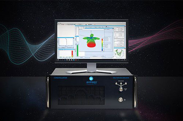
Syntony GNSS has doubled the SDR L1C/A equivalent signals of its multi-GNSS simulation solution, Constellator.
With Constellator’s computation power doubled from 660 L1C/A equivalent signals to 1200, users can simulate a complex RF environment for GNSS testing with a powerful and high-fidelity machine, the company said. Additionally, users can now test equipment with multiple traditional GNSS constellations and new ones to come, such as Xona’s PULSAR.
As a result of doubled computation, massive new constellations can be simulated. When fully deployed, the Xona constellation will count hundreds of satellites on multiple bands, in complex RF environments including specific atmospheric parameters, jamming, spoofing and multipath. It also introduces the controlled reception pattern antenna (CRPA) testing capacities of the device, when the demand is increasing for resilient multi-GNSS and low-Earth orbit (LEO) position, navigation and timing (PNT) solutions.
Syntony said it was the first PNT services provider to integrate all Xona demo signals into Constellator, in 2022. However, to offer a full testing solution, Syntony also developed a Xona-enabled GNSS receiver.
An exclusive interview with Tim Erbes, Technical Director, Safran Federal Systems (formerly Orolia Defense & Security). For more exclusive interviews from this cover story, click here.
What are currently the key challenges for simulation?
One of our big challenges is determining what performance requirements are necessary for our users. Often, they can’t determine what the specs need to be. All they know is that they need it to work. “I need this receiver from one company, this IMU from another company, and the simulator I got from you guys to work together and I need the performance to match reality.” It can be very challenging to say, “What are the requirements for the simulator? How accurate does it need to be? What types of things matter in this integration?”
Often, we’re left trying to figure that out. So, that’s an interesting, maybe unexpected challenge. It’s easy to look at the datasheet and see what some specs are, but it’s a much harder thing to say, “Well, what do you need the specs to be?” So, we’ve been working with our customers to try to nail down some of those specs, particularly with Wavefront. We have some specs on such things as phase alignment and phase stability. But how do you translate that into something like “Well, I just want the CRPA to work the same in the lab as it does in the real world?” There’s not a direct, easy way to do that. We’re in the middle of trying to figure that out. That’s definitely one of our challenges.
What about the increase in jamming and spoofing threats?
In the last five years, we’ve seen a lot more open talk about jamming and spoofing in the world. The receiver manufacturers must think about this a lot more. What’s interesting from a simulator point of view is that this is not actually new for us. We have the advantage that we’ve been designing to program requirements for years and they have included jamming and spoofing for years. So, in a way, simulation is ahead of this state of the world. Jamming and spoofing are not new or hard ideas for us. In fact, spoofing is similar to simulation. So, we already know how to do that.
Image: Safran Federal Systems (formerly Orolia Defense & Security)
However, jamming and spoofing are new to programs and integration labs. So, there might be platforms where they’re now testing against jamming or spoofing requirements where in the past, maybe they didn’t do that. They certainly can use our simulators to help them do that. However, we’re not seeing a lot of new requirements coming to us saying we need new jamming or spoofing capabilities, because we already have them. Luckily, we are future oriented regarding the jamming and spoofing requirements, so those really haven’t been a challenge for us yet.
That can always change, right? If new requirements come up, such as higher data rates or wider bandwidth waveforms or different types of waveforms, then we would have to adapt and add support for that kind of stuff. As of right now, however, we aren’t really seeing that. So, luckily, we’re prepared for that. As for the industry as a whole, there has definitely been a big movement in the last few years to understand the effects of jamming and spoofing. Simulation is a big part of that.
What about the completion of the BeiDou and Galileo constellations?
For a long time, we simulated four constellations. Then that began to get fuzzy. Do you consider SBAS a constellation or is that just an augmentation? Do you count EGNOS and other supplemental constellations for the other constellations? What about NavIC and QZSS? Before you know it, you start to lose track of exactly how many you have. We just released our 8th constellation, Xona.We’re going to be demonstrating it at JNC.
Tell me more about that.
We are trying to have all the constellations and that can be a fuzzy definition. Does that mean all that are up there right now or all that will be up there in the future? We’re trying to be forward looking and add everything that is going to be up there or might be up there so that lab users can develop and test. Multi-constellation simulation is a particularly challenging problem for groups that don’t have simulators. If you’re just doing research on, say, GPS, and want a new code, you might be able to do that in a lab on your own. But as soon as you say, “I want to do research on whether this LEO constellation helps navigation on a receiver that also uses Galileo and GPS,” suddenly, your research requires a full multi-constellation simulation.
There are two choices. One is to have a simulator do the constellations that already exist, and then you have some research to add constellations. That can be very challenging, especially with time alignment and things like that. The other is to have a simulator that can do all the constellations. That would be the easy choice, right? That presents a problem with such things as LEO navigation being on the rise and these constellations that are just emerging, that are still not even fully defined.
So, we’re trying to build those into our simulation products, to help researchers and decision makers determine whether these will be useful features to add to their receivers or their systems. We have the advantage of having a software-defined architecture. We designed the software so that it is easy to add new constellations to it. Basically, once we’re given a proper ICD, we’re only a couple of months away from a first draft implementation of that new signal. Then we iterate. There used to always be a government-driven, multi-year program to develop an ICD. Now, we have this new concept of the signal manufacturers. We’re seeing private companies release signal specs. That’s a very different way of creating a signal in a constellation. So, sometimes you don’t get much time between when the ICD is available and when simulator users want to use that constellation. Having a software-defined architecture really helps us move quickly. We can add such things as Xona very fast.
Xona told me a couple of days ago that they will soon put out an ICD. What’s the difference between actual signals that you can record and play versus something that’s only on paper?
That’s a great point. Probably many people don’t realize, when they first look at this, that what’s in the ICD and what’s on live sky are sometimes very different. Is the simulator supposed to match live sky? Or is it supposed to match the intended final state of the constellation, according to the ICD? This is a huge topic for M-Code, which is ever changing, and has a very large ICD that’s been released. Space Systems Command/Military Communications & Position, Navigation, & Timing (MCPNT) controls the features and releases them incrementally. We’re constantly having to make changes to the simulator to match those releases. The same is true for the other ICDs. At the Institute of Navigation Joint Navigation Conference (JNC), we will demonstrate an expanded PRN. I think this showed up in the ICD a couple of years ago, but it’s not used by any users yet. Some of the receiver manufacturers are starting to look at using PRNs beyond 32. So, we’re adding that to the simulator. This has already happened for BeiDou as well. I think their ICD goes up to more than 60 satellites. It’s an ever-changing race. The ICDs are constantly being updated and we’re trying to update the simulator.
Image: Safran Federal Systems (formerly Orolia Defense & Security)
Meanwhile, live sky is many years behind the paper, right? This creates an interesting challenge: when you design a system, are you designing it for today or for the future? We have users in both groups. We have users that only care about what is happening today, because they need a model. Maybe you want to model a specific mission and you want to make sure that everything’s going to go properly. Or maybe you’re designing a system that you want to release in three or four years, and you want to make sure that it’s going to work with the state of the system then.
A big challenge is to make sure that we’re keeping pace with all these ICDs. There are more constellations than ever and the technology makes it easier to change signal architectures. We’re seeing signals change faster than we’ve ever seen them change before. We go to conferences and hear about such things as on-orbit reprogramming and signals that might even change specs while they’re being transmitted. Maybe they don’t even have to have a fixed bandwidth or fixed bit rate. We’re going to start talking about signals that can reprogram on the fly. That’s going to make simulation more and more challenging. The technology exists to do this.
Software-defined waveforms is a very logical step. In the software world, we have this concept of version nightmare. When you have 20 different pieces of software that are interdependent, it can get very challenging. We’re going to start to see that in simulators. We’re going to see, “Hey, what version of navigation authentication are you using? We updated it six months ago. Are you using the new one or the old one? Which one should we use?” Well, it depends on what your receiver is using. It’s going to be interesting and challenging to keep all this straight in the next few years as things evolve. Certainly, however, our goal is to be there for all of it and to be as fast and as forward thinking as we can for our customers. That means that we also need to know what our customers need. So, we’re always looking for feedback and requests, what challenges our customers face and we’re responding to those requests.
Tell me more about the difference between simulators used by receiver manufacturers in their labs as they’re tweaking receivers or developing new ones vs. simulators used for mission planning.
The simulators are the same, but they’re used in very different ways. In most lab simulation, what the constellation looks like that day doesn’t matter very much. They can just run with a default constellation for a given day. They’ll run that scenario hundreds or thousands of times and never need to change it because they’re testing parts of the receiver that don’t care a whole lot about the specifics of what’s happening.
Whereas missions are time- and location-specific.
Yeah, exactly. They want to know which satellites will be overhead at an exact time and place. It’s not so much a problem anymore, but there used to be certain days and times when you would not get enough satellites in view, or you might have very bad dilution of precision, and your mission might actually fail. We’re past those days. There are now enough satellites up there. Most receivers will navigate within their specs most of the time in most places. However, for critical missions, such as military operations or rocket launches, you might not want to just assume that any day is a good day. So, if you’re about to launch a rocket, you might want to check. “What does the constellation look like right now?” The challenges that brings is that simulators have a default constellation, but the constellations are constantly changing.
When you’re doing real day mission planning, the big problem isn’t so much how to generate a signal, it’s how to find out what’s happening today. That’s really the nature of the problem because what’s out there today is different from what was happening yesterday or what will happen tomorrow. You might have unhealthy satellites. You need to know that if you want to model them. It becomes a big challenge to get all the right data into the simulator. Once all that data is in there, then it’s the same as any other simulation.
Are there good sources for current data on GLONASS, BeiDou and Galileo?
Image: Safran Federal Systems (formerly Orolia Defense & Security)
There are a couple of websites that provide information about where the satellites currently are. However, we’ve found that each one of those sites has its own challenges. Some are maybe 30 minutes out of date, which is pretty good, but puts the satellites in slightly different spots. Some of those sites only support some of the constellations. We’re talking about multiple countries and they don’t all agree on how this should be done. So, there’s not a single point that you can visit to get all the satellite data. There are a couple of companies that try to fix this. U-blox has AssistNow; Qualcomm has an assist for its cellular receivers; Trimble, NovAtel, and a couple of other companies have their error correction services to which you can subscribe to get some of that data.
If you want real-time up-to-date ephemeris for all the constellations, that is challenging. There are one or two options we have found that seem to work, but they each have their disadvantages. Maybe they don’t have all the satellites. Again, we’re talking about versioning issues. So, if you’ve designed your system with a certain version of an ICD and they’ve added more satellites since, those new SVs maybe aren’t so important for your users, so you don’t publish them. Other users want those satellites. So, we see versioning issues in these data streams. For example, we use the CORS network to get a lot of GPS data but that whole network, as far as I know, is only running the legacy data. As far as I know, no network is distributing the L1C modernized data that we will need at some point. So, as we launch new signals and constellations, we need the networks to provide this new data.
What are some other challenges?
For us, being a software-defined simulator on a platform dependent on software-defined radio (SDR), we’re constantly looking at what’s changing in the SDR technology community. There’s always some interesting stuff happening there that we try to incorporate. We don’t have any big announcements this year, as far as new architectures or anything like that. However, the SDR community is evolving. It’s still a rather new industry. A few years ago, we were an early adopter of SDR technology for mass deployment. Now, we’re seeing some more mature SDRs starting to push such things as channel count and coherency. We will probably take advantage of that in the future.
The other interesting thing technology-wise is that we’re also a GPU-dependent technology. So, as the GPU industry continues to evolve and makes bigger and faster GPUs, we get a relatively low-cost way to upgrade. We don’t have to do a lot of R&D to upgrade to a new GPU. For our users that means that the number of signals they can generate on their simulators is always increasing even using the same hardware from one generation to the next. Our first simulator did 75 signals; the next version did 150. We could build a system that did more than 1,000 signals, but our users don’t need it.
I assume that the growth curve for GPUs is steeper than that for signals.
I think that you’re right about that. I’m sure glad they do, because then something like Xona shows up and we don’t have to rearchitect our system to generate 300 signals, right? At JNC we will show expanded PRN, 300 Xona satellites in the constellation, and a 10 fold improvement on Wavefront performance specs.. We will continue to build simulators that meet our customers’ requirements. Besides GPUs, a lot of the technology involves software R&D and signals. The stuff that we do digitally inside of our system that allows us to do things like extremely precise phase alignment on Wavefront, for example. We spent a lot of time developing that stuff.
Image: Safran Federal Systems (formerly Orolia Defense & Security)
As the number of constellations, satellites, and signals has grown in recent years — especially in the past few years, with the completion of the BeiDou and Galileo constellations — simulator manufacturers have been challenged to keep up. Threats of jamming and spoofing also increased. Then, a few companies began to develop new positioning, navigation and timing (PNT) constellations in low-Earth orbit (LEO).
Due to the limited space available in print, I was able to use only used a small portion of the interviews I conducted for our August cover story. For full transcripts of them see below:
Full interview with Tim Erbes, Technical Director, Safran Federal Systems (formerly Orolia Defense & Security).
Full interview with JulianThomas, Managing Director, Racelogic.
Full interview with Jürgen Pielmeier, Managing Director, IFEN.
Full interview with Mark Holbrow, VP of Product Development, Spirent Communications and Roger Hart, Sr. Director of Engineering, Spirent Federal Systems.
Xona Space Systems has partnered with the Air Force Research Laboratory (AFRL) and the U.S. Space Force under a $1.2 million Direct to Phase II SBIR (Small Business Innovation Research) contract to work toward a secure low Earth orbit (LEO) positioning, navigation and timing (PNT) constellation leveraging Xona’s PULSAR service.
The contract was awarded through an AFWERX SBIR Open Topic, after Xona demonstrated its LEO PNT technology using the “Huginn” demo satellite in late 2022.
Xona is developing PULSAR – a high-performance PNT service enabled by a commercial constellation of dedicated LEO satellites.
The PULSAR service aims to advance PNT security, resilience and accuracy capabilities by augmenting existing GNSS while also operating as an independent PNT constellation.
“Our partnership with the AFRL Space Vehicles directorate and USSF’s Space Warfighting Analysis Center will give Xona the expertise necessary to seamlessly integrate PULSAR into the U.S. national security space architecture,” said Brian Manning, CEO, Xona Space Systems. “Early assessment of unique DOD PNT requirements will set us up for a successful transition to operational service.”
Colonel Jeremy Raley, commander of the Phillips Research Site and director of the AFRL Space Vehicles Directorate, said the investment will contribute to force design analytics that consider contributing signals from multiple orbit regimes.
“Lessons from this effort will pave the way for future defense programs to successfully utilize commercial space assets for flexible and diverse satnav that is resilient to the adversarial threat,” Raley said.
Preceding the award, Xona became the first company to launch a privately funded PNT mission progressing from concept to on-orbit in less than 12 months. Since then, Xona has partnered with major companies such as Hexagon | NovAtel, Septentrio, Spirent, Safran, and StarNav. In April 2023, the company moved into its new headquarters in Burlingame, California, where the company plans to start the production of PULSAR satellites.
Advanced industrial societies are increasingly reliant on the fantastic capabilities of global navigation satellite systems (GNSS) — GPS, GLONASS, BeiDou and Galileo — and, therefore, increasingly vulnerable to their weaknesses. From providing our position on a map on our smartphone to timing financial transactions, cell phone base stations, and the internet; from steering tractors in the field to guiding first responders; from giving surveyors sub-centimeter accuracy to monitoring continental drift; from providing navigation to ship captains and airplane pilots, to enabling automated control of earth moving machinery, GNSS have become a critical infrastructure. Yet their well-known vulnerabilities — such as jamming, spoofing, multipath and occultation — continue to fuel the development of complementary sources of positioning, navigation and timing (PNT) data, especially for new and rapidly expanding user segments such as autonomous vehicles.
In a January 2021 report, the U.S. Department of Transportation pointed out that “suitable and mature technologies are available to owners and operators of critical infrastructure to access complementary PNT services as a backup to GPS.”1
Several new PNT systems are being developed and deployed that are partially or entirely independent of the four existing GNSS constellations. This cover story focuses on the following companies, products and services:
Safran Federal Systems (formerly Orolia Defense & Security) makes the VersaPNT, which fuses every available PNT source — including GNSS, inertial, and vision-based sensors and odometry. I spoke with Garrett Payne, Navigation Engineer.
Xona Space Systems is developing a PNT constellation consisting of 300 low-Earth orbit (LEO) satellites. It expects its service, called PULSAR, to provide all the services that legacy GNSS provide and more. I spoke with Jaime Jaramillo, Director of Commercial Services.
Spirent Federal Systems and Spirent Communications are helping Xona develop its system by providing simulation and testing. I spoke to Paul Crampton, Senior Solutions Architect, Spirent Federal Systems as well as Jan Ackermann, Director, Product Line Management and Adam Price, Vice President – PNT Simulation at Spirent Communications.
Satelles has developed Satellite Time and Location (STL), a PNT system that piggybacks on the Iridium low-Earth orbit (LEO) satellites. It can be used as a standalone solution where GNSS signals will not reach, such as indoors, or are otherwise unavailable. I spoke with Dr. Michael O’Connor, CEO.
Locata has developed an alternative PNT (A-PNT) system that is completely independent from GNSS and is based on a network of local ground‐based transmitters called LocataLites. I spoke with Nunzio Gambale, founder, chairman, and CEO.
Due to the limited space available in print, this article only uses a small portion of these interviews. For full transcripts of them (totaling more than 10,000 words) click here.
1 Andrew Hansen et al., Complementary PNT and GPS Backup Technologies Demonstration Report, prepared for the Office of the Assistant Secretary for Research and Technology, Department of Transportation, January 2021, p. 195.
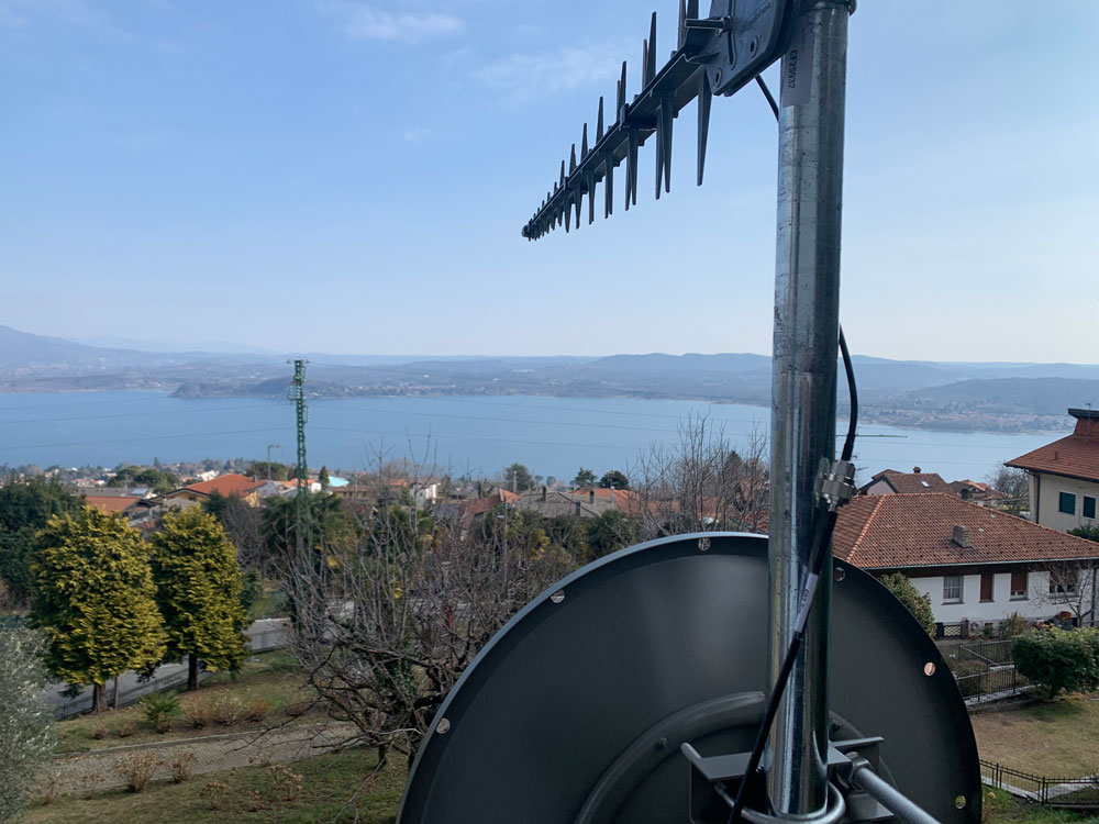
Locata dish antenna pointed to the European Union’s Joint Research Center in Ispra, Italy, 44 km away, just under the setting sun. The Yagi antenna above is pointed to a cell tower in Como and used to connect the system for remote control and data logging. (Image: Locata)
Complementary PNT
“Traditionally, augmentation to GNSS has been done through inertial navigation systems (INS),” Price said. “More recently, ground- and space-based augmentation systems have increased in usage. However, both technologies depend on the absolute positioning information provided by GNSS. They do not represent a true alternative PNT.”
To facilitate the development of advanced and autonomous applications, Price suggested incorporating terrestrial sources of PNT as well as ones based on LEO, medium-Earth orbit (MEO) and geostationary equatorial orbit (GEO) satellites. This, he added, would also keep costs from becoming prohibitive. “LEO brings many benefits in comparison to MEO in just about every industry to which it can be applied,” Jaramillo said.
While mass reliance on GNSS facilitates access to GNSS data and makes devices that use it increasingly cost-effective, over-reliance on a single sensor is risky, Austin pointed out.
“That’s where complementary PNT comes in: if you can put your eggs in other baskets, so you have that resilience or redundancy, then you can continue your operation — be it survey, automotive or industrial — even if GNSS falls or is intermittently unavailable or unavailable for a long time,” Austin said.
It has been said that “the only replacement for GNSS is another GNSS.” Inertial navigation, dead reckoning, lidar, and referencing local infrastructure that, in turn, has been globally referenced using GNSS, enable mobile platforms to maintain relative positioning during GNSS outages. However, absolute positioning will continue to require GNSS. “If you claim to be breaking free from GNSS you’re really saying, ‘I can navigate in this building, but I don’t know where this building is,’” Austin said.
GNSS-INS Integration
GNSS and INS have always been natural allies because they complement each other. The recent completion of the BeiDou and Galileo constellations, which has greatly increased the number of satellites in view, has made the requirement for six satellites at any one time for real-time kinematic (RTK) “a much more reasonable proposition,” Austin said. Coupled with the drop in the price of inertial measurement units (IMU), this has made it possible to “make a more cost-effective IMU than ever or spend the same and get a much better sensor than you ever could before,” he said. “Your period between the GNSS updates is also less noisy and you have less random walk and more stability.”
It used to be that the performance of an accelerometer might far outweigh that of a gyroscope, resulting in excellent velocity but poor heading. “Now,” Austin said, “we can pick a much more complementary combination of sensors and manufacture and calibrate an IMU ourselves while using off-the-shelf gyroscopes and accelerometers. That allows us to make an IMU that is effectively not bottlenecked in any one major area.”
Autonomous vehicles require decimeter accuracy to keep to their lane, while their absolute position is irrelevant to that task. It is, however, essential for map navigation and to know about infrastructure such as traffic signs and stoplights that may not be in a vehicle’s line of sight.
“That’s where the global georeferencing comes in and where GNSS remains critical,” Austin said. “One of the key things we’re examining is GNSS-denied navigation: how we can improve our inertial navigation system via other aiding sources and what other aiding sensors can complement the IMU or inertial measurement unit to give you good navigation in all environments. Use GNSS when it’s good, don’t rely on it when it’s bad or completely absent.”
Nowadays, car makers are increasingly moving their research and development tests from indoor, controlled environments to open roads. Therefore, “they are looking for a technology that allows them to keep doing those tests that they did on the proving ground, but in real world scenarios,” Austin said. “So, they rely on the INS data to be accurate all the time. In autonomy and survey, on the other hand, the INS is used actively to feed another sensor to either georeference or, in the case of autonomy, actively navigate the vehicle. So, that data being accurate is critical because an autonomous vehicle without accurate navigation cannot move effectively and would have to revert to manual operation.”
Image: Xona Space Systems
New vs. Old
Complementary PNT systems differ from legacy GNSS along several variables. One is coverage. For example, Satelles and Xona will provide global coverage, while Versa PNT and Locata are local. Another is encryption. Unlike GPS, which encrypts only its military SAASM/M-code signal, Xona’s PULSAR system will encrypt all its signals, Jaramillo said. “For autonomous applications, security is very important. If you’re riding in an autonomous car, you certainly don’t want somebody to be able to spoof the GNSS signal and veer it off course.”
Additionally, the design of Xona’s constellation includes a combination of polar and inclined orbits, which will greatly improve coverage in the polar regions compared to current GNSS coverage. This is particularly important as climate change makes the arctic more accessible. “The idea of having a LEO-based constellation is to take advantage of what can be done in LEO for GNSS,” Jaramillo said. “If you want the most resilient time and position, you need to use a combination of everything.”
Based on its architecture, Jaramillo said, Xona will provide better timing accuracy than GNSS does today. “Our satellites are designed to use GPS and Galileo signals, as well as inputs from ground stations, for timing reference and will share their time amongst themselves. We will average all these timing inputs and build a clock ensemble on the satellites. That enables much higher accuracies than just having a few single inputs.”
Satelles’ STL service can either substitute for GNSS where the latter is unavailable or supplement it where it is available. When used as a supplement, “the goal is having a solution that is resilient to an outage, interference, jamming, spoofing, those sorts of things,” O’Connor said. “In that case, the receiver card that might be provided by one of our partner companies would have both GNSS and STL capabilities and would take the best of both worlds.” Depending on the product configuration, its locational accuracy is generally in the 10- to 20-meter range, O’Connor said.
Orolia Defense & Security’s Versa PNT “is an all-in-one PNT solution that provides positioning, navigation, and very accurate timing,” Payne said. “Every type of sensor that you’re using for PNT has its strengths and weaknesses. That’s why we have a very accurate navigation filter solution that dynamically evaluates the sensor inputs.” In GNSS-degraded environments, the Versa’s software alerts users that GNSS signals are not reliable, automatically filters out those measurements, and navigates on the basis of the other sensors, such as an IMU, a speedometer, an odometer, or a camera.
Locata’s system is completely independent of GNSS because it does not require atomic clocks. At its heart is the company’s TimeLoc technology, which generates network synchronization of less than a nanosecond, Gambale said. “TimeLoc,” Locata literature states, “synchronizes the co-located signals with other LocataLites as the signals are slewed until the single difference range between it and the other LocataLites is the geometric range. This internal correction process is accurate to millimeter level.” Applications of this system include indoor positioning for consumer devices such as mobile phones, industrial machine automation for warehousing and logistics, positioning first responders within buildings, and military applications in GPS-jammed environments.
Constellations and Timelines
How long will it take to develop and/or complete these complementary PNT systems?
Xona is a start-up, and its timeline will depend on its success with investors.“We have basically locked down our signal and system architecture. Now, it’s a matter of building out the ground segment and launching satellites,” Jaramillo said.
Xona’s current target is to launch its first satellites into operation by the beginning of 2025 and to achieve full operational capability by 2027. The company will roll out PULSAR in phases. “In our first phase, we’re going to offer timing services and GNSS augmentation that only require one satellite in view,” Jaramillo said. “Then, as we roll out to phase two, we’ll be able to start to offer positioning services in mid-latitudes with multiple satellites in view. Phase three will include high-performance PNT and enhancements globally.”
Satelles’ STL is already on Iridium’s 66 active satellites, which are all relatively new, having been launched between 2016 and 2018, and cover the entire globe constantly. STL’s signal and capability are flexible, O’Connor said.
Orolia Defense & Security is now evaluating UWB computer technology from different vendors and integrating it in the Versa’s software. “We will probably begin performing full field tests in the first quarter of 2024,” Payne said.
Locata’s mission, Gambale said, “is to deliver technology advances which enable complete, independent sovereign control over PNT for companies, critical infrastructure systems, and in the future – entire nations. It’s designed for the many entities and nations which do not have – and can never afford – their own constellations”.
“Our business model,” Gambale added, “is based on enabling others – from companies through to nations – to develop their systems and products based upon our core technology developments. We do not dictate how our technology will be deployed. Locata’s technology can be available to any suitably qualified partner, to fashion our core developments for their own use.”
The Launch of a Falcon 9 rocket carrying Xona satellites. (Image: Xona Space Systems)
Business Model
It is challenging for any new commercial entrant in the PNT field to challenge a free global service, such as GPS. While all these new services are the opposite of GPS, which is a gift from U.S. taxpayers to the world, their business models vary somewhat.
“We are targeting both mass market applications and high-performance ones,” Jaramillo said. “For the mass market applications, our business model includes a lifetime fee: a customer pays a fee one time, and the service works for the life of the device. For higher performance applications that have more capabilities associated with them, there will be different tiers, each with different services.”
These will include an integrity service that will verify that the signal has a certain level of performance thresholds, for use in critical applications. “If it drops below certain performance thresholds,” Jaramillo said, “we will flag that to the device so that it knows that, even though it is receiving a signal, it should not continue to use it due to signal degradation.”
Receivers and Chipsets
Predictably, these new ventures have spawned a web of alliances.
The success of both Xona and Satelles will hinge in part on the availability of receivers for their signals. To manufacture them, Xona is “in discussions with just about every tier one manufacturer out there,” Jaramillo said. “We have a strong relationship with Hexagon | NovAtel. They have been supportive of us for a long time now and are very advanced in their development and support for our signals.” Additionally, Xona designed its signals “so that most receivers can support them with just a firmware upgrade.”
Satelles is also working with partners, including Adtran (through their Oscilloquartz product line), Jackson Labs (now VIAVI Solutions), and Orolia (now Safran Trusted 4D). “Companies like that provide the solutions that are favored by critical infrastructure providers today,” O’Connor said. “They ultimately integrate our STL capability into their solutions. They can use our reference designs or create their own custom designs based on our reference designs.”
Satelles uses a different process to take measurements of the STL satellite signals than legacy GNSS. “It’s not a single chip that’s measuring both satellites, it’s ultimately two chips that are making those measurements,” O’Connor explained. “Then, we leave it to our partners to determine how to perform the position calculation and the integration of those signals. It can be integrated loosely or tightly.”
Markets and Applications
The target markets and applications for these new PNT services also vary.
The markets in which Satelles has the highest adoption rates are data centers, stock exchanges and 5G networks, said O’Connor. He pointed out that 5G networks need about five to 10 times more nodes to cover a geographic area than 4G networks.
“GNSS has been used for years to time 4G networks, but most 5G network sites — such as femtocells and picocells — are indoors or in places where GNSS is challenged. We deliver that timing service indoors, outdoors, everywhere.” Generally, an STL-only solution is best suited for timing, O’Connor said. “It will do timing at about 100 ns, depending on what kind of oscillator is being used and the exact configuration of the product.”
Orolia provides precise position, timing, and situational awareness for different applications. “Our systems can be used for ground, air and sea-based applications,” Payne said. “At Orolia Defense and Security we market to the U.S. government, defense organizations and contractors.” Beyond those arenas, however, its systems can be used “anywhere accurate position and/or timing is needed.”
Versa PNT. (Image: Safran Federal Systems)
The Role of Simulation
Simulation plays an important role in the development of new PNT systems. “Before the Xona constellation or any other emerging constellation has deployed any satellites, simulation is the only way for any potential end-user or receiver OEM to assess its benefits,” Ackermann said. “Before you can do live sky testing, a key part of enabling investment decisions — both for the end users as well as the receiver manufacturers, and everybody else — is to establish the benefits of an additional signal through simulation.”
Then, new receivers must be validated to ensure they perform as intended. “The best way to do that is with a simulator,” Jaramillo said. “Spirent works with two levels of customers: first, the receiver manufacturers, then all the application vendors that use those receivers.”
Spirent Communications did that for Xona’s system using its new SimXona simulator. “First, we did in-depth validation ourselves,” Ackermann said. “Then, we worked in a close partnership with Xona for them to certify that against their own developments. So, we followed a proven development approach. It’s just that, in this case, the signal comes out of a LEO.” Spirent Communications’ sister company Spirent Federal Systems also provided support to Xona, said Crampton.
Validation and Adoption
The European Commission’s Joint Research Centre in Ispra, Italy, recently conducted an eight-month test campaign to assess the performance of alternative PNT (A-PNT) demonstration platforms, including Satelles and Locata. According to the final report, released in March 2023, the demonstrations “showcased precise and robust timing and positioning services, in indoor and outdoor environments. [T]ime transfer technologies over different means were demonstrated, including over the air (OTA), fiber, and wired channels. The results … showed that all A-PNT platforms under evaluation demonstrated performances in compliance with the requirements set.”
Satelles has also been working with the U.S. National Institute of Standards and Technology (NIST) to evaluate its system. “They have subjected STL to rigorous third-party, hands-off technology evaluations,” O’Connor said. “They confirmed the timing accuracy specifications to UTC and validated the operational characteristics of STL, such as the resilience in the absence of GNSS, the ability to receive the signal indoors, and having global availability.”
The industry is now focused on adoption. “All the providers of these capabilities ultimately need adoption in industry to remain active and viable,” O’Connor said.
With the recent completion of two new GNSS constellations, the growth in the number and variety of augmentation services, and the development and deployment of complementary PNT products and services, the geospatial industry is at an inflection point.