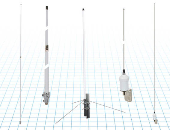
Fairview Microwave has launched commercial marine-grade ship/boat RF antennas that provide accurate positioning with L1 band and multiband capabilities, and offer a 28 dBi gain for reliable positioning.
Fairview’s antennas offer full-spectrum connectivity and operate within the universal marine frequency range of 156 MHz to 163 MHz and CB-27 MHz, 10m-HAM, ensuring unbroken connections at sea. The antennas are also weatherproof, rated IP67 for water ingress.
The antennas are offered with three types of mounts, making it easier to integrate into any vessel.
All antennas are crafted from robust stainless steel or fiberglass for durability and reliable performance. Various antenna lengths are available for users to select based on their signal performance needs.
Russia released a large number of attack UAVs targeting Kyiv, Ukraine, in the early morning of June 20, reported the New York Times. The UAV attack on Kyiv was the first in several weeks after Russian forces repeatedly targeted the city throughout May.
The air-raid alert started in Kyiv around 3 a.m. local time and lasted for more than three hours, as UAVs came in waves from all directions. According to the New York Times, Ukraine’s Air Force said Russian forces had launched 35 Iranian-made UAVs around Kyiv.
Ukraine air defenses shot down 32 of the UAVs, which included more than a dozen near the capital.
On June 21, Reuters reported that Russian air defense had downed three UAVs in the Moscow region in what they believe to have been a Ukrainian attack. The Defence Ministry stated that Russian forces had used electronic jamming, which caused the UAVs to lose control and crash.
Reuters could not independently verify details of this incident or who had launched the UAV attack.
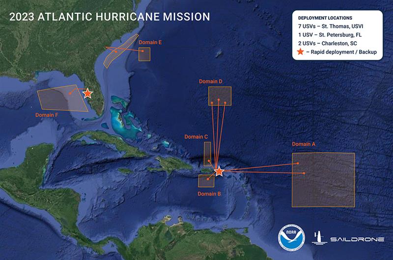
Graphic showing the USV domain areas during the 2023 Atlantic Hurricane mission. (Image: SailDrone)
Saildrone — a data solutions company for maritime security, ocean mapping, and ocean data — is deploying 12 uncrewed surface vehicles (USV) into the tropical Atlantic and Gulf of Mexico this summer, supporting the research by the National Oceanic and Atmospheric Administration (NOAA) to advance hurricane forecasting.
Saildrone is deploying 10 USVs from St. Thomas, U.S. Virgin Islands, St. Petersburg, FL, and Charleston, SC, to operate in areas with a high probability of intercepting a storm, as indicated by historical data. Two vehicles will remain on land, ready for quick deployment in the event of an approaching hurricane.
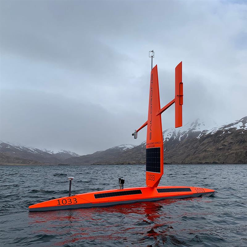
Image: SailDrone
A Saildrone Explorer is a 23-ft USV propelled by the wind and powered by solar energy. During the past two missions in 2021 and 2022, Saildrone vehicles sailed through several storms and major hurricanes, including Hurricane Sam in 2021, and Hurricane Fiona in 2022.
In addition to the Saildrone Explorers, NOAA is using a variety of aerial, surface, and sub-surface technologies, — including its Hurricane Hunter airplanes, small, uncrewed aircraft systems, gliders, drifters and floats.
The goal is to create a complete picture of the ocean-atmosphere interactions that drive hurricanes.
The USVs will transmit data, including air temperature and relative humidity, barometric pressure, wind speed and direction, water temperature and salinity, sea surface temperature, and wave height and period in near real time to scientists at NOAA’s Atlantic Oceanographic and Meteorological Laboratory and Pacific Marine Environmental Laboratory, Saildrone’s science partners for the mission.
NOAA will use the data collected by the USVs to improve hurricane forecast models. The data will also be archived by NOAA’s National Environmental Satellite, Data and Information Service and sent by NOAA to the World Meteorological Organization’s Global Telecommunication System, where it is available for the world’s major forecast centers — some 20 agencies worldwide, including NOAA.
Borderless Capital has invested in the Global Earth Observation Decentralized Network (GEODNET) Foundation via its EdgeFi Fund, the first web3 investment fund focused on decentralized physical infrastructure networks. The investment will be utilized to strengthen GEODNET’s mission with emphasis on growing reliable global coverage and a mobile operating-system software development kit.
The GEODNET Foundation manages the open network protocol and promotes service usage within the traditional GNSS and IoT industry.
With more than 3,000 reference stations online in every major continent, the real-time GEODNET network is the largest decentralized geospatial reference network. The GEODNET location service offers reliable centimeter-accurate location for applications such as UAVs, robotic vehicles, augmented reality, and IoT/mobile devices.
GEODNET station data is actively utilized by companies such as Hemisphere GNSS, Quectel Wireless Solutions and Rock Robotic. GEODNET stations owners set up a satellite mining station and are rewarded with the project’s native polygon token, GEOD.
Advanced industrial societies are increasingly reliant on the fantastic capabilities of global navigation satellite systems (GNSS) — GPS, GLONASS, BeiDou and Galileo — and, therefore, increasingly vulnerable to their weaknesses. From providing our position on a map on our smartphone to timing financial transactions, cell phone base stations, and the internet; from steering tractors in the field to guiding first responders; from giving surveyors sub-centimeter accuracy to monitoring continental drift; from providing navigation to ship captains and airplane pilots, to enabling automated control of earth moving machinery, GNSS have become a critical infrastructure. Yet their well-known vulnerabilities — such as jamming, spoofing, multipath and occultation — continue to fuel the development of complementary sources of positioning, navigation and timing (PNT) data, especially for new and rapidly expanding user segments such as autonomous vehicles.
In a January 2021 report, the U.S. Department of Transportation pointed out that “suitable and mature technologies are available to owners and operators of critical infrastructure to access complementary PNT services as a backup to GPS.”1
Several new PNT systems are being developed and deployed that are partially or entirely independent of the four existing GNSS constellations. This cover story focuses on the following companies, products and services:
Safran Federal Systems (formerly Orolia Defense & Security) makes the VersaPNT, which fuses every available PNT source — including GNSS, inertial, and vision-based sensors and odometry. I spoke with Garrett Payne, Navigation Engineer.
Xona Space Systems is developing a PNT constellation consisting of 300 low-Earth orbit (LEO) satellites. It expects its service, called PULSAR, to provide all the services that legacy GNSS provide and more. I spoke with Jaime Jaramillo, Director of Commercial Services.
Spirent Federal Systems and Spirent Communications are helping Xona develop its system by providing simulation and testing. I spoke to Paul Crampton, Senior Solutions Architect, Spirent Federal Systems as well as Jan Ackermann, Director, Product Line Management and Adam Price, Vice President – PNT Simulation at Spirent Communications.
Satelles has developed Satellite Time and Location (STL), a PNT system that piggybacks on the Iridium low-Earth orbit (LEO) satellites. It can be used as a standalone solution where GNSS signals will not reach, such as indoors, or are otherwise unavailable. I spoke with Dr. Michael O’Connor, CEO.
Locata has developed an alternative PNT (A-PNT) system that is completely independent from GNSS and is based on a network of local ground‐based transmitters called LocataLites. I spoke with Nunzio Gambale, founder, chairman, and CEO.
Due to the limited space available in print, this article only uses a small portion of these interviews. For full transcripts of them (totaling more than 10,000 words) click here.
1 Andrew Hansen et al., Complementary PNT and GPS Backup Technologies Demonstration Report, prepared for the Office of the Assistant Secretary for Research and Technology, Department of Transportation, January 2021, p. 195.
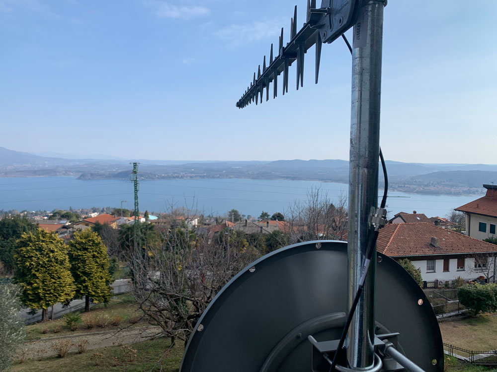
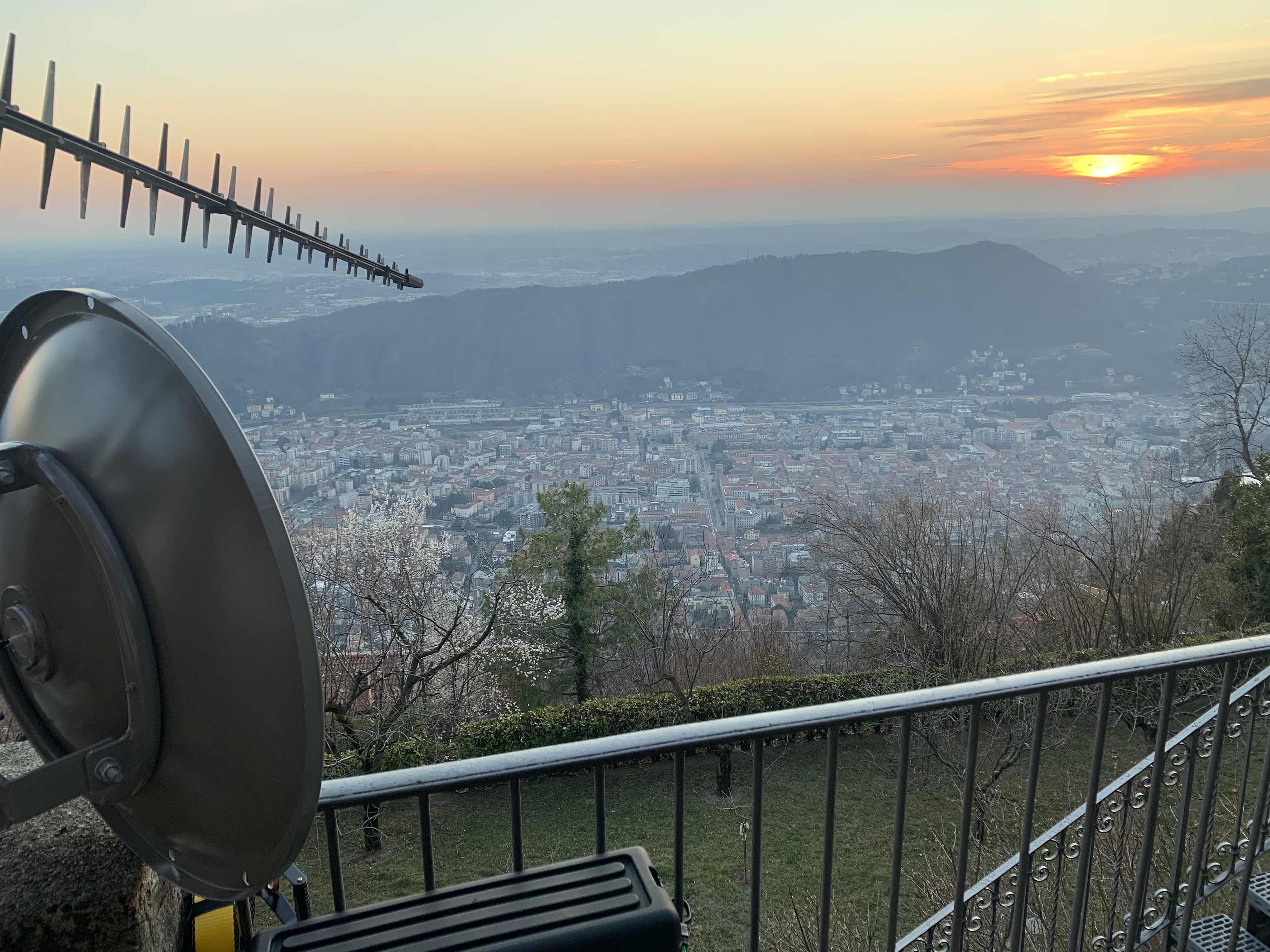
Locata dish antenna pointed to the European Union’s Joint Research Center in Ispra, Italy, 44 km away, just under the setting sun. The Yagi antenna above is pointed to a cell tower in Como and used to connect the system for remote control and data logging. (Image: Locata)
Complementary PNT
“Traditionally, augmentation to GNSS has been done through inertial navigation systems (INS),” Price said. “More recently, ground- and space-based augmentation systems have increased in usage. However, both technologies depend on the absolute positioning information provided by GNSS. They do not represent a true alternative PNT.”
To facilitate the development of advanced and autonomous applications, Price suggested incorporating terrestrial sources of PNT as well as ones based on LEO, medium-Earth orbit (MEO) and geostationary equatorial orbit (GEO) satellites. This, he added, would also keep costs from becoming prohibitive. “LEO brings many benefits in comparison to MEO in just about every industry to which it can be applied,” Jaramillo said.
While mass reliance on GNSS facilitates access to GNSS data and makes devices that use it increasingly cost-effective, over-reliance on a single sensor is risky, Austin pointed out.
“That’s where complementary PNT comes in: if you can put your eggs in other baskets, so you have that resilience or redundancy, then you can continue your operation — be it survey, automotive or industrial — even if GNSS falls or is intermittently unavailable or unavailable for a long time,” Austin said.
It has been said that “the only replacement for GNSS is another GNSS.” Inertial navigation, dead reckoning, lidar, and referencing local infrastructure that, in turn, has been globally referenced using GNSS, enable mobile platforms to maintain relative positioning during GNSS outages. However, absolute positioning will continue to require GNSS. “If you claim to be breaking free from GNSS you’re really saying, ‘I can navigate in this building, but I don’t know where this building is,’” Austin said.
GNSS-INS Integration
GNSS and INS have always been natural allies because they complement each other. The recent completion of the BeiDou and Galileo constellations, which has greatly increased the number of satellites in view, has made the requirement for six satellites at any one time for real-time kinematic (RTK) “a much more reasonable proposition,” Austin said. Coupled with the drop in the price of inertial measurement units (IMU), this has made it possible to “make a more cost-effective IMU than ever or spend the same and get a much better sensor than you ever could before,” he said. “Your period between the GNSS updates is also less noisy and you have less random walk and more stability.”
It used to be that the performance of an accelerometer might far outweigh that of a gyroscope, resulting in excellent velocity but poor heading. “Now,” Austin said, “we can pick a much more complementary combination of sensors and manufacture and calibrate an IMU ourselves while using off-the-shelf gyroscopes and accelerometers. That allows us to make an IMU that is effectively not bottlenecked in any one major area.”
Autonomous vehicles require decimeter accuracy to keep to their lane, while their absolute position is irrelevant to that task. It is, however, essential for map navigation and to know about infrastructure such as traffic signs and stoplights that may not be in a vehicle’s line of sight.
“That’s where the global georeferencing comes in and where GNSS remains critical,” Austin said. “One of the key things we’re examining is GNSS-denied navigation: how we can improve our inertial navigation system via other aiding sources and what other aiding sensors can complement the IMU or inertial measurement unit to give you good navigation in all environments. Use GNSS when it’s good, don’t rely on it when it’s bad or completely absent.”
Nowadays, car makers are increasingly moving their research and development tests from indoor, controlled environments to open roads. Therefore, “they are looking for a technology that allows them to keep doing those tests that they did on the proving ground, but in real world scenarios,” Austin said. “So, they rely on the INS data to be accurate all the time. In autonomy and survey, on the other hand, the INS is used actively to feed another sensor to either georeference or, in the case of autonomy, actively navigate the vehicle. So, that data being accurate is critical because an autonomous vehicle without accurate navigation cannot move effectively and would have to revert to manual operation.”
Image: Xona Space Systems
New vs. Old
Complementary PNT systems differ from legacy GNSS along several variables. One is coverage. For example, Satelles and Xona will provide global coverage, while Versa PNT and Locata are local. Another is encryption. Unlike GPS, which encrypts only its military SAASM/M-code signal, Xona’s PULSAR system will encrypt all its signals, Jaramillo said. “For autonomous applications, security is very important. If you’re riding in an autonomous car, you certainly don’t want somebody to be able to spoof the GNSS signal and veer it off course.”
Additionally, the design of Xona’s constellation includes a combination of polar and inclined orbits, which will greatly improve coverage in the polar regions compared to current GNSS coverage. This is particularly important as climate change makes the arctic more accessible. “The idea of having a LEO-based constellation is to take advantage of what can be done in LEO for GNSS,” Jaramillo said. “If you want the most resilient time and position, you need to use a combination of everything.”
Based on its architecture, Jaramillo said, Xona will provide better timing accuracy than GNSS does today. “Our satellites are designed to use GPS and Galileo signals, as well as inputs from ground stations, for timing reference and will share their time amongst themselves. We will average all these timing inputs and build a clock ensemble on the satellites. That enables much higher accuracies than just having a few single inputs.”
Satelles’ STL service can either substitute for GNSS where the latter is unavailable or supplement it where it is available. When used as a supplement, “the goal is having a solution that is resilient to an outage, interference, jamming, spoofing, those sorts of things,” O’Connor said. “In that case, the receiver card that might be provided by one of our partner companies would have both GNSS and STL capabilities and would take the best of both worlds.” Depending on the product configuration, its locational accuracy is generally in the 10- to 20-meter range, O’Connor said.
Orolia Defense & Security’s Versa PNT “is an all-in-one PNT solution that provides positioning, navigation, and very accurate timing,” Payne said. “Every type of sensor that you’re using for PNT has its strengths and weaknesses. That’s why we have a very accurate navigation filter solution that dynamically evaluates the sensor inputs.” In GNSS-degraded environments, the Versa’s software alerts users that GNSS signals are not reliable, automatically filters out those measurements, and navigates on the basis of the other sensors, such as an IMU, a speedometer, an odometer, or a camera.
Locata’s system is completely independent of GNSS because it does not require atomic clocks. At its heart is the company’s TimeLoc technology, which generates network synchronization of less than a nanosecond, Gambale said. “TimeLoc,” Locata literature states, “synchronizes the co-located signals with other LocataLites as the signals are slewed until the single difference range between it and the other LocataLites is the geometric range. This internal correction process is accurate to millimeter level.” Applications of this system include indoor positioning for consumer devices such as mobile phones, industrial machine automation for warehousing and logistics, positioning first responders within buildings, and military applications in GPS-jammed environments.
Constellations and Timelines
How long will it take to develop and/or complete these complementary PNT systems?
Xona is a start-up, and its timeline will depend on its success with investors.“We have basically locked down our signal and system architecture. Now, it’s a matter of building out the ground segment and launching satellites,” Jaramillo said.
Xona’s current target is to launch its first satellites into operation by the beginning of 2025 and to achieve full operational capability by 2027. The company will roll out PULSAR in phases. “In our first phase, we’re going to offer timing services and GNSS augmentation that only require one satellite in view,” Jaramillo said. “Then, as we roll out to phase two, we’ll be able to start to offer positioning services in mid-latitudes with multiple satellites in view. Phase three will include high-performance PNT and enhancements globally.”
Satelles’ STL is already on Iridium’s 66 active satellites, which are all relatively new, having been launched between 2016 and 2018, and cover the entire globe constantly. STL’s signal and capability are flexible, O’Connor said.
Orolia Defense & Security is now evaluating UWB computer technology from different vendors and integrating it in the Versa’s software. “We will probably begin performing full field tests in the first quarter of 2024,” Payne said.
Locata’s mission, Gambale said, “is to deliver technology advances which enable complete, independent sovereign control over PNT for companies, critical infrastructure systems, and in the future – entire nations. It’s designed for the many entities and nations which do not have – and can never afford – their own constellations”.
“Our business model,” Gambale added, “is based on enabling others – from companies through to nations – to develop their systems and products based upon our core technology developments. We do not dictate how our technology will be deployed. Locata’s technology can be available to any suitably qualified partner, to fashion our core developments for their own use.”
The Launch of a Falcon 9 rocket carrying Xona satellites. (Image: Xona Space Systems)
Business Model
It is challenging for any new commercial entrant in the PNT field to challenge a free global service, such as GPS. While all these new services are the opposite of GPS, which is a gift from U.S. taxpayers to the world, their business models vary somewhat.
“We are targeting both mass market applications and high-performance ones,” Jaramillo said. “For the mass market applications, our business model includes a lifetime fee: a customer pays a fee one time, and the service works for the life of the device. For higher performance applications that have more capabilities associated with them, there will be different tiers, each with different services.”
These will include an integrity service that will verify that the signal has a certain level of performance thresholds, for use in critical applications. “If it drops below certain performance thresholds,” Jaramillo said, “we will flag that to the device so that it knows that, even though it is receiving a signal, it should not continue to use it due to signal degradation.”
Receivers and Chipsets
Predictably, these new ventures have spawned a web of alliances.
The success of both Xona and Satelles will hinge in part on the availability of receivers for their signals. To manufacture them, Xona is “in discussions with just about every tier one manufacturer out there,” Jaramillo said. “We have a strong relationship with Hexagon | NovAtel. They have been supportive of us for a long time now and are very advanced in their development and support for our signals.” Additionally, Xona designed its signals “so that most receivers can support them with just a firmware upgrade.”
Satelles is also working with partners, including Adtran (through their Oscilloquartz product line), Jackson Labs (now VIAVI Solutions), and Orolia (now Safran Trusted 4D). “Companies like that provide the solutions that are favored by critical infrastructure providers today,” O’Connor said. “They ultimately integrate our STL capability into their solutions. They can use our reference designs or create their own custom designs based on our reference designs.”
Satelles uses a different process to take measurements of the STL satellite signals than legacy GNSS. “It’s not a single chip that’s measuring both satellites, it’s ultimately two chips that are making those measurements,” O’Connor explained. “Then, we leave it to our partners to determine how to perform the position calculation and the integration of those signals. It can be integrated loosely or tightly.”
Markets and Applications
The target markets and applications for these new PNT services also vary.
The markets in which Satelles has the highest adoption rates are data centers, stock exchanges and 5G networks, said O’Connor. He pointed out that 5G networks need about five to 10 times more nodes to cover a geographic area than 4G networks.
“GNSS has been used for years to time 4G networks, but most 5G network sites — such as femtocells and picocells — are indoors or in places where GNSS is challenged. We deliver that timing service indoors, outdoors, everywhere.” Generally, an STL-only solution is best suited for timing, O’Connor said. “It will do timing at about 100 ns, depending on what kind of oscillator is being used and the exact configuration of the product.”
Orolia provides precise position, timing, and situational awareness for different applications. “Our systems can be used for ground, air and sea-based applications,” Payne said. “At Orolia Defense and Security we market to the U.S. government, defense organizations and contractors.” Beyond those arenas, however, its systems can be used “anywhere accurate position and/or timing is needed.”
Versa PNT. (Image: Safran Federal Systems)
The Role of Simulation
Simulation plays an important role in the development of new PNT systems. “Before the Xona constellation or any other emerging constellation has deployed any satellites, simulation is the only way for any potential end-user or receiver OEM to assess its benefits,” Ackermann said. “Before you can do live sky testing, a key part of enabling investment decisions — both for the end users as well as the receiver manufacturers, and everybody else — is to establish the benefits of an additional signal through simulation.”
Then, new receivers must be validated to ensure they perform as intended. “The best way to do that is with a simulator,” Jaramillo said. “Spirent works with two levels of customers: first, the receiver manufacturers, then all the application vendors that use those receivers.”
Spirent Communications did that for Xona’s system using its new SimXona simulator. “First, we did in-depth validation ourselves,” Ackermann said. “Then, we worked in a close partnership with Xona for them to certify that against their own developments. So, we followed a proven development approach. It’s just that, in this case, the signal comes out of a LEO.” Spirent Communications’ sister company Spirent Federal Systems also provided support to Xona, said Crampton.
Validation and Adoption
The European Commission’s Joint Research Centre in Ispra, Italy, recently conducted an eight-month test campaign to assess the performance of alternative PNT (A-PNT) demonstration platforms, including Satelles and Locata. According to the final report, released in March 2023, the demonstrations “showcased precise and robust timing and positioning services, in indoor and outdoor environments. [T]ime transfer technologies over different means were demonstrated, including over the air (OTA), fiber, and wired channels. The results … showed that all A-PNT platforms under evaluation demonstrated performances in compliance with the requirements set.”
Satelles has also been working with the U.S. National Institute of Standards and Technology (NIST) to evaluate its system. “They have subjected STL to rigorous third-party, hands-off technology evaluations,” O’Connor said. “They confirmed the timing accuracy specifications to UTC and validated the operational characteristics of STL, such as the resilience in the absence of GNSS, the ability to receive the signal indoors, and having global availability.”
The industry is now focused on adoption. “All the providers of these capabilities ultimately need adoption in industry to remain active and viable,” O’Connor said.
With the recent completion of two new GNSS constellations, the growth in the number and variety of augmentation services, and the development and deployment of complementary PNT products and services, the geospatial industry is at an inflection point.
Max Weber famously described how bureaucratic inertia often leads formal organizations, such as government agencies, to devise new justifications for themselves after they have outlived their original purpose. That is certainly not the case for the U.S. Space Force, which is in its infancy and is responsible for key missions, including operating the Global Positioning System that it took over from the United States Air Force about two years ago.
However, bureaucratic inertia can also refer to the tendency of organizations to continue to pursue projects or approaches that may no longer be the best match for their goals, missions, or budgets. A recent, congressionally-mandated report by the United States Government Accountability Office (GAO) — Report to Congressional Committees, GPS MODERNIZATION: Space Force Should Reassess Requirements for Satellites and Handheld Devices, issued in June — questions the Space Force’s approach to modernizing GPS with a more jam-resistant, military-specific signal known as M-code.
In 2005, the Air Force launched the first GPS satellite capable of broadcasting the M-code signal, which is at the core of a multi-billion-dollar modernization and sustainment effort. Yet, 18 years later, widespread adoption of the technology is still hampered by delays in upgrading GPS ground and user equipment. Approximately 700 types of weapon systems — including ground vehicles, ships and aircraft — will ultimately require M-code-capable user equipment.
Providing M-code requires the cooperation of GPS’ ground, space and user equipment segments. Regarding the first one, the report states: “In 2022, Space Force further delayed delivery of the ground control segment due to development challenges. This delay pushes delivery until December 2023 at a minimum. Space Force officials have not finalized a new schedule and acknowledged that remaining risks could lead to additional delays.”
Regarding the space segment, it states: “Space Force met its approved requirement for 24 M-code-capable satellites on orbit but determined that it needs at least three more to meet certain user requirements for accuracy. Building and maintaining this larger constellation presents a challenge. GAO’s analysis indicates it is not likely that 27 satellites will be available on a consistent basis over the next decade.”
Finally, regarding the user segment, it notes that development of the Military GPS User Equipment (MGUE) Increment 1 has progressed “to the point where the military departments are ready to commence activities in support of testing and fielding it on the lead weapon systems.” However, it cautions that “[d]elays and unexpected challenges could affect the fielding of capability for some systems.”
GAO’s report recommends that the United States Department of Defense (DOD) assess the number of GPS satellites necessary to meet operational needs, and either develop a sound business case for the M-code-capable Increment 2 handheld, or not initiate the effort. The DOD concurred with both recommendations.
“Who Runs GPS?”, the special feature in our February 2023 issue, which detailed the structure of this vast enterprise, listed an executive committee, a coordination office, an oversight council, two Space Force commands, and, as partners, several federal departments and agencies. Has this complex structure become too diffuse to make tough decisions?
Safran Electronics & Defense and Terran Orbital have partnered to study and validate the prerequisites to produce an electric propulsion system for satellites in the United States, based on Safran’s PPSX00 plasma thruster.
Under the partnership, Safran and Terran Orbital will investigate the technical, industrial and economic prerequisites for Safran’s PPSX00 plasma thrusters are designed to meet the mobility requirements of low-Earth orbit (LEO) satellites, such as offering a higher degree of spacecraft maneuverability to avoid collisions and a system to safely deorbit LEO satellites at the end of their service life.
“Our alliance with Terran Orbital will contribute to the emergence of a complementary source of supply for electric propulsion systems to meet the growing needs of the space industry,” Jean-Marie Bétermier, senior vice president of space, Safran Electronics & Defense, said.
Electric propulsion uses electrical and/or magnetic fields to accelerate mass to high speed – thus, generating thrust to modify the velocity of a spacecraft in orbit.
Rohde & Schwarz, in collaboration with Qualcomm Technologies, have partnered to conduct a comprehensive set of tests for narrowband-internet of things (NB-IoT) over non-terrestrial networks (NTN). This test aims to accurately verify two-way IoT data across various operating modes using geosynchronous orbit (GSO) and geostationary orbit (GEO) constellations in line with the 3GPP Release 17.
The companies will conduct a broad range of tests that address the many challenges inherent to satellite-based, non-terrestrial networks that use GSO and GEO constellations. The test set covers time and frequency synchronization from prolonged delays and the Doppler Effect, low signal-to-interference-plus-noise ratio, power saving mechanisms, satellite ephemerides, GNSS acquisition and more.
These tests will be a validation tool for Qualcomm Technologies’ NTN chips — the 212S and 9205S. The R&S CMW500 protocol testing framework scenarios and the R&S CMW 3GPP Release 17 NTN IoT protocol enabler on a single R&S CMW500 wideband radio communication tester will help engineers assess their NTN NB-IoT devices powered by Qualcomm Technologies’ NTN chips under realistic conditions.
The R&S CMW500 wideband radio communication tester emulates GSO and GEO satellite base stations in combination with the R&S SMBV100B, which generates GNSS signals. Establishing a real-time, comprehensive connection with the simulated GSO/GEO satellite network lets engineers test relevant signaling and RF scenarios in line with 3GPP Release 17.
At the MWC Shanghai 2023, Rohde & Schwarz will hold a live demonstration of the test solution at its booth with Qualcomm Technologies’ NTN Release 17 IoT chipsets.
Safran Electronics & Defense has been selected by the Greek army (officially called the Hellenic Armed Forces) to enhance its tactical UAV fleet by incorporating four Patroller tactical UAVs. NATO‘s Support and Procurement Agency (NSPA) facilitated the contract on behalf of the Greek army during the Paris Air Show 2023.
Set to be implemented by 2024, the Patrollers will operate alongside Greece’s current fleet of 16 Sperwer tactical unmanned aircraft from Sagem, a French defense company. Greece also requested three ground stations.
The Patroller achieved a milestone in February 2023 when it became the first tactical UAV system officially certified to NATO airworthiness standard STANAG 4671.
Equipped with multiple sensors designed for intelligence missions, the Patroller UAV serves the needs of armies and homeland security forces. With an autonomy of more than 15 hours, the Patroller UAV also features a high payload capacity — allowing the integration of various specialized sensors and weapons, which enables it to meet diverse operational requirements.
Turkish Aerospace Industries (TAI) will begin distributing Anka, its medium-altitude long-endurance class UAVs, to several countries this year, reported the Daily Sabah. Chief Product Engineer, Ziya Dogan, added that an export deal was signed with another country for the delivery in 2024, but did not mention anything specific.
The Anka UAV has more than 30 hours of endurance and a payload capacity of more than 350 kg. It is designed primarily for the Turkish Air Force.
Anka performs day and night all-weather reconnaissance, target detection and identification and intelligence missions. The UAV also features autonomous flight capability, including automatic takeoff and landing.
Anyone reading my previous columns knows that I have been highlighting the new, modernized, National Spatial Reference System (NSRS) of the National Geodetic Survey (NGS). During the 2023 Fédération Internationale des Géomètres (FIG) Working Week held on May 28 – June 30, in Orlando, Florida, NGS held an all-day session addressing various topics related to the NSRS modernization project.
More than 30 NGS staff members supported two days of sessions that included a day on the NSRS modernization, sessions for the Young Surveyors Network, and FIG Commission 5 meetings, which focused on meeting the highest accuracy levels for positioning and measurement.
Juliana Blackwell, director of NGS, kicked off the third plenary session tackling the global challenges, with a presentation titled “The Modernized U.S. National Spatial Reference System — Aligning National Geospatial Data to the Globe.”
Blackwell highlighted the importance of geospatial data from many different sources being interoperable and defined within a modern reference frame. She noted that NGS is part of the National Oceanic and Atmospheric Administration (NOAA), the mission of which is to understand and predict changes in climate, weather, ocean, and coasts. This includes a mandate to define, maintain and provide access to the NSRS.
NGS’s NSRS modernization project has been underway for a decade and is nearly complete. Blackwell explained that the new NSRS will align critical U.S. geospatial data assets within global data inventories and enable improved analysis and modeling of climate changes and impacts to society and the environment. The modernized NSRS will enable data integration of new and old technologies, adopts modern standards, and empowers growth in new fields and applications.
The remainder of the presentations during the all-day event covered three themes: the practical implications of NSRS modernization — changing survey methodology; an update on the NOAA CORS Network and the Online Positioning User Service (OPUS); and case studies of surveys — what NGS does now and how they will change.
Many of these topics have been discussed by NGS during their webinar series, but during these presentations NGS provided the latest information on many of the activities associated with the modernization of the NSRS. This venue allowed for participants to ask questions as opposed to typing them in a box. Also, the NGS employees that participated in the FIG working week were available for discussions before and after the session. I enjoyed my discussions with old colleagues as well as meeting some new NGS employees.
The session titled “Practical Implications of NSRS Modernization — Changing Survey Methodology” addressed the following topics:
practical impacts of the modernized NSRS
Canada’s implementation of the modernized frames
changes afoot: State Plane 2022 and Retirement of the U.S. Survey Foot and
preparing for the modernization of the NSRS.
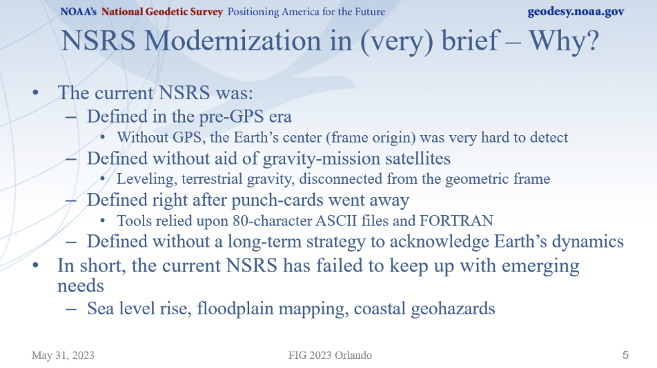
Dru Smith, NSRS modernization manager, started by explaining the practical impact of the modernized NSRS and why it is needed. He mentioned that the current NSRS was defined in the pre-GNSS era and that it has failed to keep up with emerging requirements, such as accurately measuring sea level rise.
(Image: NGS Website)
He highlighted the practical implications of the modernized NSRS, such as that every latitude, longitude, and ellipsoid height will change from its NAD 83 values in the +/-2-meter range, and every orthometric height will change from its NAVD 88 values in the +/-2-meters median range.
He mentioned that the published coordinate functions of the NOAA CORS Network (NCN) will be the primary geodetic control of the NSRS. He noted that NGS is working on the integration of web-based tools to improve consistency and reduce confusion, such as enhancements to NGS’s OPUS to ingest digital data from surveying instruments directly into OPUS 6 via a Geodetic Data Exchange (GDX) format. This would include raw measurements from GNSS receivers, levels, total stations, and gravimeters. The talk titled “Augmenting Data Exchange Formats for OPUS of the Future” by Ryan Hardy, discussed the GDX format in more detail.
As with the International Terrestrial Reference Frame, the modernized NSRS will have a time-dependency component. It will be built into the new NSRS, but users will have the ability to disengage from it.
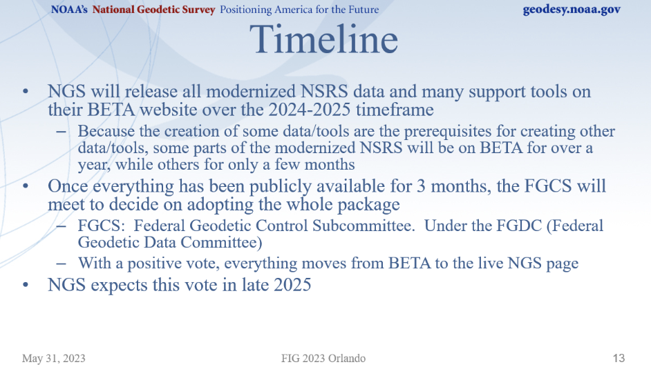
Smith provided a timeline of the project for the next couple of years, which can be referenced in the image below. NGS plans to release data and support tools on their BETA website during 2024 and 2025.
(Image: NGS Website)
Smith discussed how some products will be released early for users to test and evaluate how the new NSRS products will affect their products and services, and to be ready for their customers after the new NSRS is released for publication. Products scheduled for early releases (Alpha Release), include SPCS2022, EPP2022, and GEOID2022.
He emphasized that Alpha products, by definition, can be one or more of the following:
incomplete
inaccurate
buggy
subject to change without notice
As such, their early release is primarily for users to see the “big picture” such as formats of data and the general direction that NGS is taking.
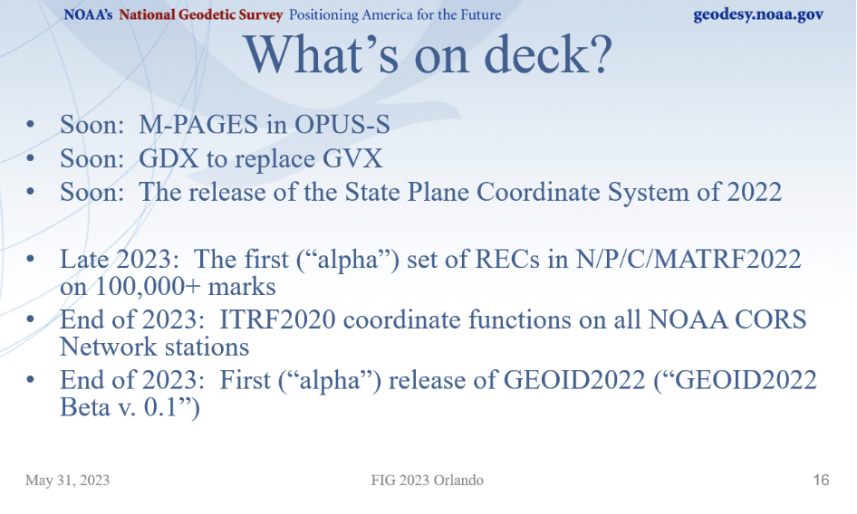
He provided a list of new products that will be announced soon, and some alpha products tentatively planned for release in 2023.
(Image: NGS Website)
Michael Dennis did a nice job of discussing the State Plane Coordinate System of 2022 (SPCS 2022) and the retirement of the U.S. Survey Foot. He mentioned that the U.S. Survey Foot was superseded by the international foot on December 31, 2022. His presentation gave a brief overview on the status and rollout plans for SPCS2022, along with how and why NGS will continue to support the U.S. Survey Foot in the existing NSRS (but not in the modernized NSRS).
See the image below for the number of zones for each state.
(Image: NGS Website)
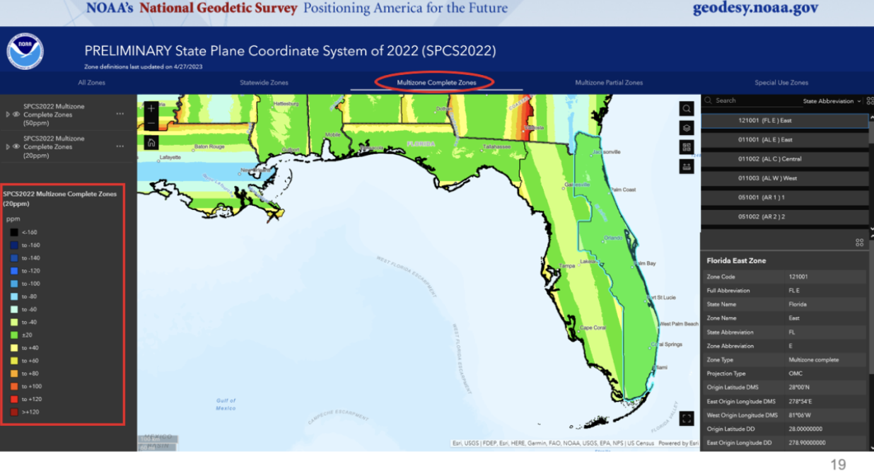
The SPCS2022 will be an alpha product released soon. Part of the alpha product will have options to view maps depicting the different zones in each state.
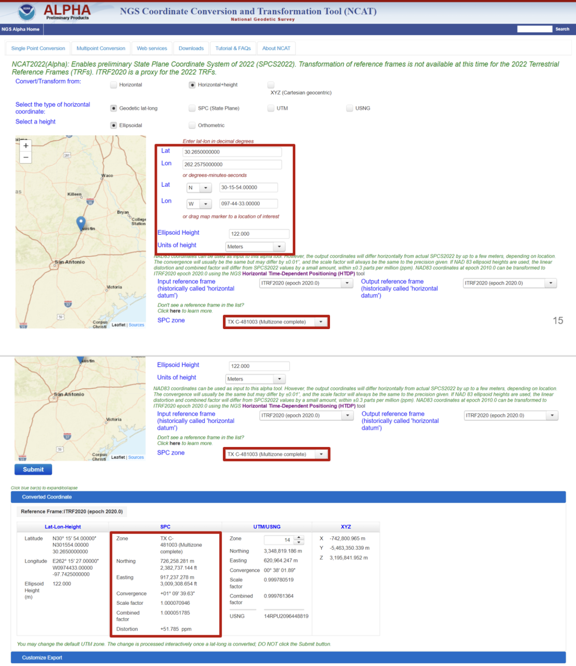
Example of Florida Multizone Complete Zones. (Image: NGS Website)
When NCAT2022 is released in alpha product it will contain the SPCS2022.
Example of NCAT2022 (Alpha). (Image: NGS Website)
Representatives from the Canadian Geodetic Survey presented and participated in the discussions.
The session titled “Update on the NOAA CORS Network and OPUS” addressed the following topics:
the NOAA CORS Network (NCN) services
updating OPUS-S to support multi-GNSS
OPUS -Projects 5: supporting RTK for establishment of geodetic control
OPUS projects for manager’s training – transitioning from instructor-led to online, self-paced instruction and
augmenting data exchange formats for OPUS of the future.
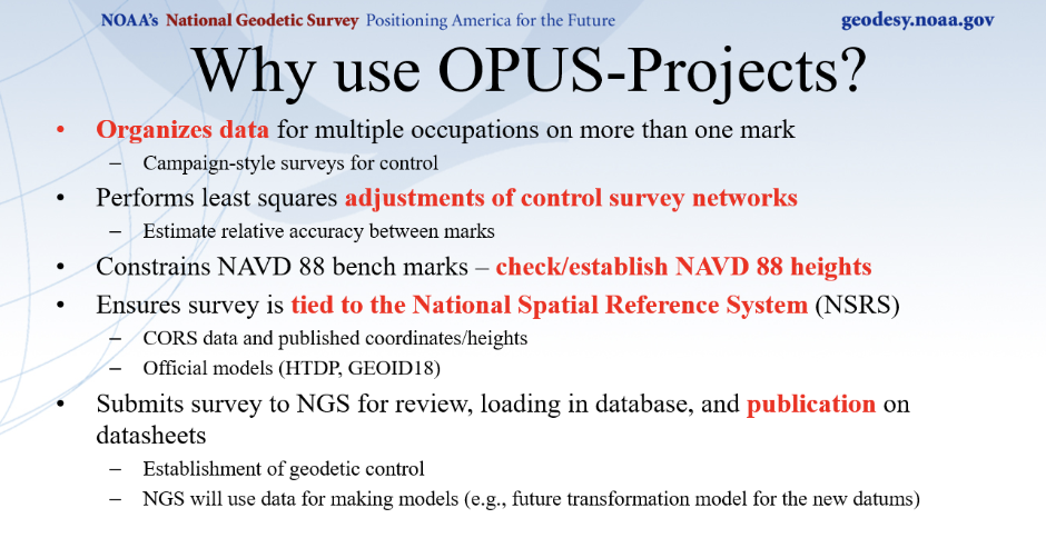
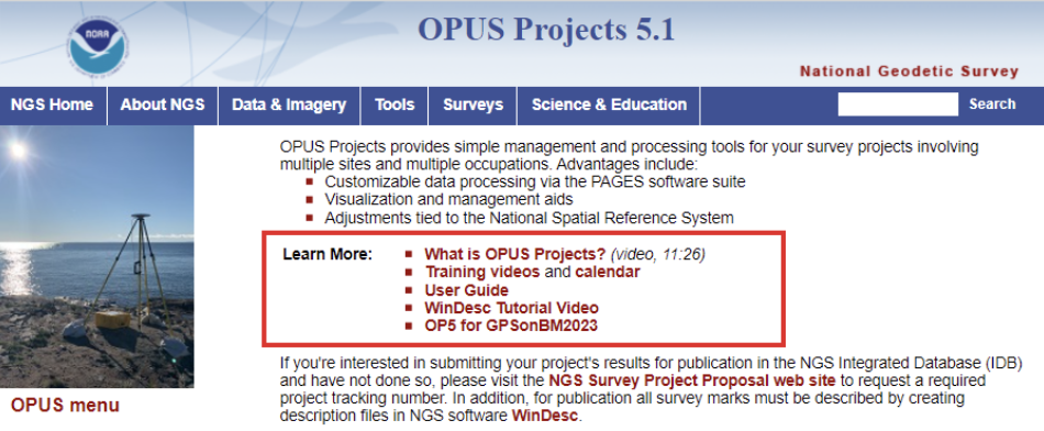
Dan Gillins gave a presentation on the advantages of using NGS’s OPUS-Projects 5 web routine. OPUS-Projects make it easier for users to submit a GNSS project to NGS for publication. I discussed OPUS-Project 5.1, when it was released as a Beta product, in my October 2021 column.
(Image: NGS Website)(Image: NGS Website)
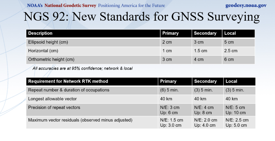
Gillins mentioned that a new publication providing guidance to meet standards for GNSS surveying is being reviewed and will be available soon. I discussed these new standards in my May 2023 column.
Ryan A. Hardy gave a talk describing the new Geodetic Data Exchange (GDX). As previously mentioned, GDX is an XML-based data format that will be the input format for OPUS. GDX will be the successor to the GNSS Vector Exchange (GVX) format. GDX currently supports GNSS, classical, and leveling measurements.
The GDX structure will have the following fields[[these are clearly the names of database fields; if it were a list of different types of information, we would not put them in all caps and would not use the underscores]]:
SOURCE_DATA
PROJECT_INFORMATION
PERSONNEL
UNITS
EQUIPMENT
POINTS
MEASUREMENT_SETTINGS
MEASUREMENTS
REDUCTIONS
OBSERVATIONS
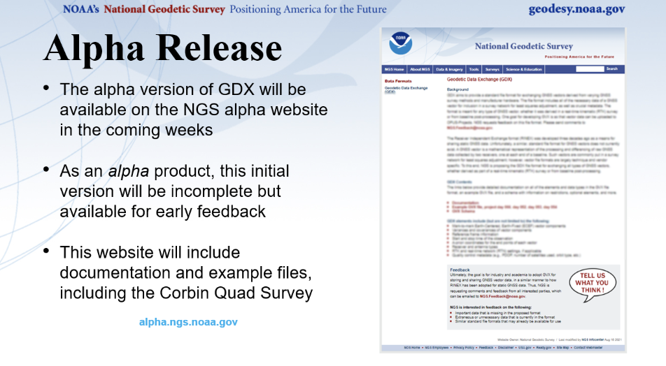
NGS is planning to release an alpha version of GDX soon.
(Image: NGS Website)
The session titled “Case Studies of Surveys — NGS Does Now and How They will Change” addressed the following topics:
implementing NGS OPUS-Projects’ GVX feature to align RTK vectors to the NSRS to establish geodetic control for FirstNet indoor mapping
IGLD: a case study for leveraging digital tools to enhance QA/QC on large scale static GNSS observation campaigns
geodetic leveling in the modernized NSRS and
NGS field operations: modernizing in many ways.
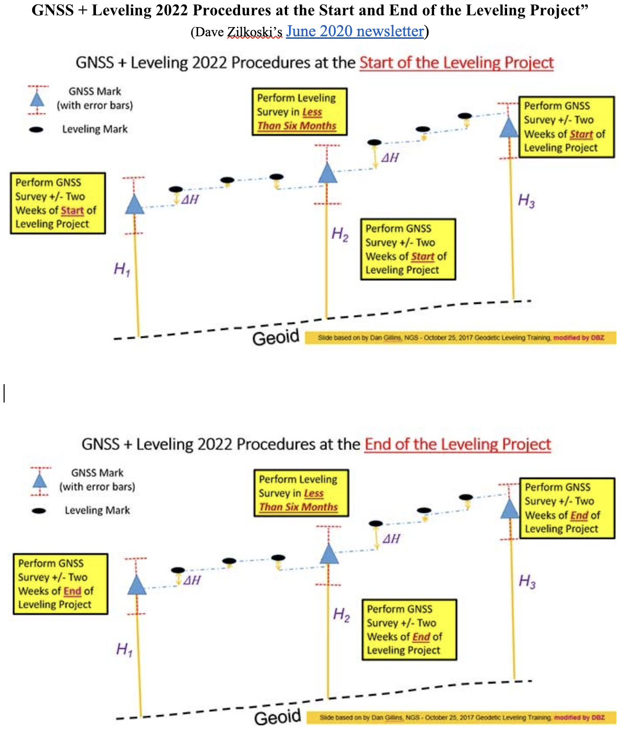
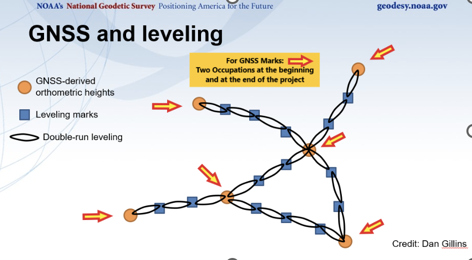
Ben Erickson gave a good presentation on leveling in the new NSRS, a topic about which I am very interested in knowing more[[Please avoid dangling participles, prepositions, conjunctions, and modifiers.]]. I discussed the new procedures in my June 2020 column.
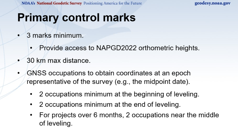
One major change is that leveling surveys will require GNSS occupations to ensure that orthometric heights computed in leveling surveys are up to date and are connected to the NSRS through the NOAA CORS Network. The network accuracy is obtained through GNSS data and a high-accuracy geoid model, and the local accuracy is provided through the leveling data. Specific procedures will be required to incorporate leveling data in the North American Pacific Geopotential Datum (NAPGD2022).
Basic Procedures for NAPGD2022 Orthometric Heights. (Image: NGS Website)
I discussed these procedures in more detail in my June 2020 column. The image below provides a conceptual diagram that illustrates what this means to a typical leveling project.
GNSS + Leveling 2022 Procedures at the Start and End of the Leveling Project”. (Image: Diagram based on information from Dan Gillins, NGS, and modified by David B. Zilkoski)
Erickson provided a diagram of a level network that contained a loop, which can be referenced below.
(Image: NGS Website)
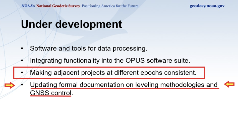
I have worked with leveling data for most of my career and I am pleased to know that NGS is going to provide tools to incorporate leveling data into the new, modernized NSRS. When performing leveling projects, there is a requirement to level to previously established benchmarks that were within a certain distance from the project. This helped to ensure that different leveling projects were consistent with each other. NGS stated that making adjacent projects at different epoch consistent is under development, and their plans include updating leveling documentation to explain the leveling methodologies and GNSS control.
(Image: NGS Website)
I have only highlighted a few of the presentations. It was an all-day session, and a lot of information was presented on the new, modernized NSRS. The presentations can be downloaded from the NGS website at https://geodesy.noaa.gov/datums/newdatums/fig-2023.shtml. I would encourage everyone to download the presentations to obtain the latest information on NGS’s modernization of the NSRS. See the image below for the list of presentations and the links to download specific presentations.
NGS Presentations at FIG 2023 Working Week. (Image: NGS Website)
An exclusive interview with Nunzio Gambale, Co-Founder, President and CEO, Locata. For more exclusive interviews from this cover story, click here.
Locata dish antenna pointed to the European Union’s Joint Research Center in Ispra, Italy, 44 km away, just under the setting sun. The Yagi antenna above is pointed to a cell tower in Como and used to connect the system for remote control and data logging. (Image: Locata)
In brief, how does Locata work? What are the key concepts?
Almost everything you know about GNSS pretty much applies to Locata. We are an extremely close cousin. We use trilateration; in other words, we use time of flight from transmitter to receiver as our pseudorange. We work with both code and carrier solutions. We transmit CDMA Gold Codes, chipped at 10MHz. Everything in the algorithms that you use for GNSS is pretty much the same, and so it feels extremely familiar to any GNSS engineer. We have an interface control document (ICD) that describes our over-the-air interface, exactly as GPS or Galileo does. That’s available to our integration partners. So, the similarities are incredibly close.
The main place where we diverge greatly from GNSS is in the use of atomic clocks. One of the three fundamentals of GNSS is that all your transmitters have to be synchronized for the trilateration to work at your receiver. Syncing the satellites requires a master clock — in the case of GPS, with a redundant feed from the U.S. Naval Observatory — and a very complex ground infrastructure. Our system requires neither atomic clocks nor a control segment. Importantly, just like GNSS, our satellites do not communicate with each other. LocataLites, our version of the satellites, only broadcast a signal, thereby enabling an unlimited number of receivers to use our devices.
Locata’s core inventive step was the Time Lock loop invented by my partner, David Small. Any engineer is familiar with a frequency lock loop or a phase lock loop, which allows you to align either phase and frequency in a very intelligent way by looking at the offsets and then moving the two components into alignment. That’s what we do with time. It is a fundamental difference from requiring clocks, which all drift and are very difficult to synchronize, as the complexity and cost of the ground segment testifies. Many people get confused because they believe that super accurate atomic clocks will all give you the same time. Clearly, that’s not the case, because they drift relative to each other. However, satellite navigation requires keeping the clocks synchronized.
Our system is a synchronization technology that does not require atomic clocks. We synchronize our transmitters to incredible levels, better than what’s generally available from the synchronization of atomic clocks. That allows us to do everything that a GNSS does in our coverage area.
We’ve invented the Time Lock loop. Dave has more than 170 granted patents on this and on multipath mitigation. Nobody else has done this or can do it. All other high-precision systems require external correction systems. Our carrier solution is a single point solution. We don’t need any external corrections provided from reference stations, or communication links between our devices. Our system is, and remains, synchronous to the picosecond level, which allows us to do carrier-phase positioning without corrections. That’s utterly unique.
As the old joke goes, a person with a watch always knows what time it is, a person with two watches never does.
That’s one of my favorite quotations for people who don’t understand this.
It has been said that the only replacement for a GNSS is another GNSS.
And my favorite riposte to that is “the solution to satellite-based problems is not more satellites”!
We now have four GNSS but they have some common failure points. What’s your view of the debate about GNSS vulnerabilities and the need for complementary PNT? How does Locata fit into it?
One of our main drivers is the knowledge that all those global systems are fundamentally military based. Galileo tries to make itself an exception, I know, but the core motivation for nations to put up these kinds of very complex and expensive systems is for full global military purposes. Locata has probably been working on this complementary PNT technology longer than just about anybody else. We began in 1995, with the problem that GNSS does not work indoors. That was the first light bulb moment for us about the issues with GNSS not being able to serve all the potential future applications. So, we’ve been at this a long time. Global systems absolutely have their place, but there are many applications now and in the future that do not require them.
Where did your realization lead you?
We started to look at ways of filling in the holes that we saw in GNSS. That led us to the two unique capabilities that we’ve currently developed and commercialized: the synchronization of transmitters, which is the heart of all radio-based positioning, and, because we work in terrestrial systems, how to deal with multipath. Those are the core new enabling capabilities that Locata brings to the industry today.
There are mountains of reports detailing the vulnerabilities of GNSS, starting with the 2001 report by the John A. Volpe National Transportation Systems Center for the U.S. Department of Transportation right through the very latest one from the European Commission’s Joint Research Center (JRC) in Ispra, Italy. All those myriad reports document the vulnerabilities of GNSS and the dire dependencies they create. These dependencies mean that the more than 95% of applications that are civilian are vulnerable, if and when the military have to do what they have to do with their systems in a military conflict. So, for us, it’s all about giving civilians and nations sovereignty, and national-level resiliency, firstly to critical infrastructure systems.
That’s what we set out to demonstrate with our long-range deployments at the JRC. Our systems must be able to be scaled, in time, from purely local up to national systems. Because Locata’s focus must be on civilian systems and sovereignty that can be delivered back to nations, with systems that are independent from the military ones. We’re not trying to replace global systems, at least for now.
GNSS provide positioning, navigation and timing (PNT) at the global level. You have addressed the global level. Let’s talk now about PNT.
P, N and T are all important. Timing, of course, is GNSS’s hidden component for most people, but it is critical to many applications. Anybody who wants to see the work that Locata has put in over the last couple of decades to bring new capabilities to the industry should look at the JRC’s report, which is the very latest and probably one of the most comprehensive reports that’s been produced in the past decade. The European engineers were incredibly thorough in the way they tested all candidate systems, including Locata. If I could speak proudly about our team’s achievements, Locata’s P, N and T results presented in that report speak for themselves. Locata’s technology was demonstrated to perform in every environment the JRC engineers requested, including indoors.
That’s one of the functions that we absolutely want to bring to market. Our systems don’t stop at the wall, they can continue to work indoors, you can propagate positioning and timing from outside to inside. The performance that was measured independently by the researchers showed that indoors we were delivering centimeter-level positioning in brutal multipath conditions, as well as outdoors.
Locata is doing superb work with some of the most complex automation systems in the world now, which unfortunately we’re constrained from discussing because of nondisclosure agreements.
Say more about the role of synchronization.
Locata dish antenna pointed to the EU’s Joint Research Centre, 8km away across Lake Maggiore in Northern Italy. This antenna was an intermediate node during the EU’s independent testing of Locata’s picosecond-level time transfer over a 105km distance. (Image: Locata)
Synchronization is the heart and soul of everything that we do with radio positioning. Clearly, Locata has been able to do high-precision synchronization without atomic clocks, at an almost unbelievable level, for many years. The first system that we deployed is at the White Sands Missile Range in New Mexico, where the U.S. Air Force jams GNSS over a vast area, yet Locata continues to deliver centimeter-level positioning and picosecond-level synchronization. That is unprecedented and cannot be done with satellite-based systems. The European JRC engineers measured our synchronization at the picosecond level, cascaded 8 times from one transmitter to another over more than 105 km. This is an extremely difficult thing to do, given that you’re trying to remove the propagation and component delays introduced by each intermediate transmitter. Our synchronization was measured to basically deliver timing equivalent to fiber, but over the air, using RF. I don’t believe any other company can demonstrate that.
This development allows us to start deploying systems commercially, which we are doing today via integration partners. In the future, as we miniaturize, bring the price down and scale our capabilities into other frequencies and at power levels that are commensurate to national-level systems, we intend to cover entire nations with our capability, and deliver not just what’s required today, but what’s required for future apps.
One of the few things that we don’t agree with in the JRC tender and report is that they set the PNT “performance bar” at 100 meters and one microsecond. For 80% or 90% of serious applications — especially for autonomous systems, and any applications that need fine control, including surveying — 100 meters is completely unusable, apart from maybe intercontinental aviation systems. Locata delivers the picoseconds and the centimeters that future applications require. As we commercialize further, we will deploy more and more systems that demonstrate that capability.
So, you could not use Locata to navigate on transoceanic flights.
No, we’re clearly not focused on doing that. We’re a business, and we’re working on the applications for which we see the most civilian, commercial value. Nevertheless, the U.S. Air Force does use Locata and so we’re in discussions with other militaries now. Clearly, we can cover very large areas — say, around airports and military bases — and continue to work at very precise levels, both for timing and positioning, in anything up to completely denied environments. It’s a proven fact that our systems are being used on a regular basis where GNSS has been jammed, and Locata is the truth for those tests. You cannot get a more convincing demonstration of non-GNSS-based PNT than the U.S. Air Force’s use of Locata at White Sands.
What about the application with by far the greatest number of users, which is cell phones?
Absolutely, without question, we believe Locata will eventually be used in mobile phone systems, especially for indoor positioning. Locata’s receivers today look very much like the 1990s version of GNSS receivers. However, there are zero engineering roadblocks to scaling or reducing our devices to a chipset. It’s a chicken and egg business development problem: you can’t get to mobile phone-type scale until you’ve engaged and are working with companies in that industry. Part of the reason we worked so diligently to demonstrate our new capabilities in the JRC tests, is that many of the claims that we’ve made about centimeters and picoseconds have been fairly unbelievable in terms of the capabilities that were previously publicly demonstrated. Our participation in the JRC tests was motivated in many ways by being able to point to the 140-page report produced by the engineers in Europe, and prove beyond question that we actually do what we claim.
We have now begun discussions with companies in the cell phone industry. Technically there’s no question that in the future we can reduce our receivers, firstly, and then our transmitters, into either chipsets or into IP cores that can be dropped into other companies’ chips. That’s a work in progress. The engineering to take this down to a chipset is now mostly constrained by not yet conducting business development in that market segment. However, we are working toward that, and are in discussion with some of the big players in that industry.
It sounds like you are working with different industries at different scales.
Locata engineers set up the distinctive VRay Orb antenna for an indoor cm-level positioning demo in the Joint Research Centre’s all-metal Workshop Building. (Image: Locata)
Yes, and the markets we are in today are delineated by the current form-factor of our devices. Today, our devices are similar to the GNSS receivers that you would have seen back in the 90s. Because we’re FPGA-based and not chip-based our devices tend to be relatively large, power-hungry and relatively expensive. That’s why we’re working into markets where that is not a roadblock. Our main partners today have massive problems that they need to solve, specifically for industrial automation applications. We’re working with some extremely large global businesses in some of the most complex and demanding automation applications in the world. It frustrates me enormously that we cannot publicize those yet because we’re under commercial non-disclosures. Therefore, we remain tight lipped about our current installations.
However, those in Locata’s inner circle know that we’re working with some of the most advanced automation capabilities in the world. I am very eager to show the world what we’re doing. And we soon will.
Obviously, the U.S. Air Force work that we’ve been doing for eight years is publicly visible. Our team right now is working with them on an extension of that contract. As I said, we’re also in discussions with some other nations and we look forward to being able to publicly disclose some of our applications in the future. For now, unfortunately, I need to remain tight lipped and just keep working on the installations that we have underway. Hopefully, soon, when these things become visible in public, I’ll finally be able to promote them.
Is sensor fusion relevant to Locata for certain applications or will it always be a standalone system?
Locata does not necessarily need to be standalone. Our partners, who are the experts in their machines and applications, are responsible for integrating Locata with other sensors, such as inertial units or cameras or lidar-based systems that may already be on their machines, just like they would with any GNSS system.
Our business model is working with partners. So, it’s a business-to-business model, whereby we partner with companies that have a problem they need to solve in their products. We work with their engineers to integrate our system — just like GNSS engineers work with their engineering partners to integrate receivers into systems of systems. That is generally what is required in many of the applications in which we’re used for autonomy.
One of the great features of our technology is that we can guarantee our partners, without fail, exactly how many Locata transmitters will be in view for their application in any area or environment. We can over-determine the solution on a site so that if, say, you get lightning strikes or power outages, the system can continue to function at the level that you require. That’s never possible with satellites, because you never know where your receivers will be relative to obstructions and the DOPs of the satellites. So, our system can be standalone. But in 90% of the applications in which we are working it is integrated into a system of systems, just like GNSS is.
What, if any, is the role of simulation with respect to your system?
We are currently in discussions with a major simulation company for integration into their software suite. They see enough demand now from enough players to be working with our integration. I can’t name them because it’s not a commercial system yet. However, they have our data and ICD, and they are working with our engineers to incorporate Locata simulations into their product offering.
Is there anything else that you would like to add?
Unlike GNSS or LEO-based systems, which take a long time to change, we can customize and modify our systems very quickly. Our next generation systems are frequency-flexible: we can put our systems into any radio band from 70 MHz, up through all the phone bands, the radio navigation bands for aviation, emergency services bands, right up to the 6 GHz WiFi bands. Those devices are in prototype right now. We can very quickly modify, update and upgrade our system, which allows us to have a very rapid development cycle that satellite-based systems will never have.
For instance, the U.S. Air Force’s NTS-3 Vanguard satellite that has been coming for several years will soon demonstrate new capabilities. Yet it will still take decades to deploy them. LEO satellites, which are getting an enormous amount of attention today, still have major constraints in terms of upgrades, modification, and or the deployment of new capabilities. Very few people in the industry talk about the replenishment of satellites which these massive constellations will need because in LEO orbits they will naturally deorbit every four to six years or so.
That means that there’s a huge requirement to continually replace LEO satellites in space, which will obviously require an enormous cost, and complex engineering effort. When you have several thousand satellites, in different planar orbits, deciding where you’re going to place replacement satellites for the many that are failing, is going to be an enormous headache for all these companies that are trying to put LEOs in space. Locata doesn’t have any of these issues. As we move forward, we will miniaturize, go to chipsets and software-defined radio capabilities. We can evolve at a rate that space-based systems can’t even begin to approach. Given that we live in an age of rapidly evolving threats and vulnerabilities, our ability to rapidly react to these challenges is, we believe, a valuable addition to the tool-box of PNT capabilities the world requires.
Thanks for allowing us this opportunity, Matteo, to speak to your large and expert audience.