An Oculii sensor placed at the front corner of a vehicle. (Photo: Oculii)
Oculii’s patented adaptive AI software increases resolution of existing RF radar silicon up to 100X
Ambarella Inc. has entered into a definitive agreement to acquire Ohio-based Oculii Corp. Oculii’s adaptive artificial intelligence (AI) software algorithms are designed to enable radar perception using current production radar chips to achieve significantly higher (up to 100x) resolution, longer range and greater accuracy.
The fusion of Ambarella’s camera technology and Oculii’s radar software stack provides an all-weather, low-cost and scalable perception solution, enabling higher levels of autonomy for Tier 1 automakers and OEMs globally.
Oculii’s technology eliminates the need for specialized high-resolution radar chips, which have significantly higher power consumption and cost than conventional radar solutions. Oculii’s software can be deployed on Ambarella’s existing CVflow systems-on-chip (SoCs), operating in conjunction with radar RF solutions to increase safety and reliability.
The acquisition expands Ambarella’s addressable market into radar perception and fusion with its existing SoCs for automotive and other internet of things endpoint applications, including mobile robotics and security.
Oculii’s superior resolution and sensitivity can unlock the potential of everything from advanced driver-assistance systems (ADAS) and autonomous vehicles to robotics and security, by providing radar with a dynamic waveform that uses AI to learn from and adapt to the environment. The result is an extended operating range of up to 400 meters with a wide field of view.
To date, Oculii is engaged with 10 of the top 15 Tier 1s on software licensing, and has commercial development contracts with other OEM and AV companies. Oculii is generating pre-production revenue today, with production programs expected to commence in CY2023.
The boards of directors at both companies have approved the transaction, which is subject to customary closing conditions and expected to close during Ambarella’s Q4 FY2022 (ending January 31, 2022). Wilson Sonsini Goodrich & Rosati served as legal advisor to Ambarella, and Goodwin Procter served as legal advisor to Oculii. Greenhill & Co. served as financial advisor to Ambarella.
SoftBank Corp., ALES Corp. and u-blox AG have signed a memorandum of understanding to cooperate in GNSS augmentation services for global markets.
SoftBank provides the “ichimill” GNSS augmentation service in Japan, its subsidiary ALES operates a business that generates and delivers positioning correction data, and u-blox is a global provider of positioning services for the automotive, industrial and consumer markets.
U-blox also provides electronic components for wireless communications and the PointPerfect GNSS augmentation service in Europe, the United States and other countries and regions.
Through this business collaboration, SoftBank, ALES and u-blox will construct GNSS augmentation infrastructure for Japan, Europe and the United States, develop GNSS receivers and devices, and expand service areas.
Collaboration Background
Since November 2019, SoftBank has been offering ichimill, a GNSS augmentation service that offers highly accurate positioning with a margin of error of a few centimeters in the Japan market. In addition to providing technology that enables the generation and delivery of correction data, ALES has been offering a centimeter-level positioning service to consumers in Japan since August 2020.
In July 2021, u-blox began providing PointPerfect, a PPP-RTK-based GNSS augmentation service, which is now available in the contiguous United States and Europe.
GNSS augmentation services like these are mainly offered separately by country and region. Client companies, which include global automotive manufacturers and agricultural machinery manufacturers, sign up for separate service contracts in each country and region, making GNSS receiver configuration more complex.
Collaboration Overview
To offer global GNSS augmentation services, SoftBank, ALES and u-blox will study the following initiatives.
Develop a global correction data delivery infrastructure. GNSS augmentation services use correction methods that differ by country and region, and there is a wide variety of correction signal formats. In 2022, the three companies will consider developing a correction data delivery infrastructure that delivers unified correction signal formats for use in any country or region. With this infrastructure, companies using ichimill or PointPerfect will be able to conduct GNSS augmentation if they are in range of both services, which will eliminate the need for separate service contracts by country or region.
Jointly develop global-compatible devices. In addition to correction data delivery, an environment that allows for the easy implementation of GNSS receivers and other devices is necessary for GNSS augmentation services. In conjunction with the launch of ichimill, SoftBank developed its own GNSS receivers and is offering them in Japan. The three companies will consider jointly developing GNSS receivers and modules that can be used globally.
Greater GNSS augmentation accuracy and service area expansion. The companies will collaborate closely to ensure that the performance of the services in all the regions covered are comparable. This is important to provide a consistent customer experience across all regions. Furthermore, the three companies plan to study service expansion into other areas, including Asia. SoftBank is promoting the deployment of non-terrestrial network (NTN) solutions that encompass satellite- and stratospheric-based telecommunication platforms to provide connectivity to the sea, the sky, developing countries and rural areas lacking internet infrastructure so everyone around the world has access to the internet. The three companies will consider the development of NTN-linked services, such as correction data delivery using small amounts of data in a way that is suitable for NTN bandwidths.
[SPONSORED CONTENT] VBOX NTRIP Modem allows you to receive RTK correction data via internet, without having to operate your own base station. By accessing public or commercial RTK networks, correction messages from a grid of permanent base stations can be received by either Wi-Fi or 4G cellular connection. Utilizing Network RTK overcomes the range restrictions of a single base station, allowing for centimeter-level RTK accuracy to be achieved over significant distances. Additionally, receiving corrections via internet rather than radio provides a more reliable signal reception as interference from changes in elevation or topographical obstacles are minimized.
If your use of RTK corrections is localized, then you can still gain the benefits of increased range and signal reliability offered by utilizing internet-based correction messages. Simply connect your base station to a computer with internet access and cast the correction messages from your base station directly to the VBOX NTRIP Modem.
The U.S. military is transitioning to M-code. When the transition is complete, what will become of the SAASM P(Y) code? What should be done with it? Should the U.S. government use it as a public authenticated service?
Jules McNeff
“In my opinion (not speaking on behalf of the Defense Department), eventual use of the P(Y) code as a public authenticated service is not feasible based on both time and accessibility. Even with the transition to M-code, the legacy P(Y) code will continue to be used by the U.S. military and by U.S. allies and partner nations as long as there are military requirements for it. More importantly, public access to the encrypted P(Y) code would require general distribution of classified cryptographic keys and associated hardware/software by the DOD. That will not happen, even if the P(Y) code use is discontinued.” Jules McNeff Overlook Systems Technologies
Bernard Gruber
“Broadly speaking, GPS user equipment security architectures transition every 10 years (such as PPS-SM/AOCs to SAASM to Modernized CGM/MSI.) It can be argued that implementation of these security measures generally takes 10 years or longer to implement. SAASM P(Y) receivers will be around for a long time, implementation can be expensive, backwards compatibility is critical. Personally, I would like to see SAASM architectures evolve to support critical services within other U.S. government departments first, and then determine a path that supports a public service as threats, unfortunately, move forward.” Bernard Gruber
Northrop Grumman
John Fischer
“Why not? Authentication protects against spoofing. I don’t know all the obstacles involved, but even if an internet connection is required to overcome the one-way limitation of GPS, that isn’t a problem for most applications. Our credit card transactions are secured this way, why not our PNT information? Decades ago, the U.S. Air Force gave the world a gift with the open GPS signal; they could do it again with a secure signal. The world would be a better place.” John Fischer
Orolia
F. Michael Swiek
“It’s premature to forecast when military operations will transition from P(Y) code even after M-code operations achieve Initial and Final Operating Capability (IOC and FOC). SAASM P(Y) code will continue to support military operations for an extended period since all MGUE receivers (both increments 1 and 2) are YMCA capable, meaning they support P(Y) code, M-code and C/A code operations. As a military-encrypted signal with military utility, military leaders must carefully weigh any potential P(Y) code transition and its impact on military operations.” Michael Swiek
GPS Alliance
Ellen Hall
“If P(Y) code is offered as a new service to the public, it will have to be maintained. This carries a great cost. This is a legacy product that had a specific military need, which has been replaced and improved upon by M-code. In today’s uncertain times, we need to be wise with our tax dollars. The cost to continue both SAASM and M-code is greater than the benefit to the public, in my opinion.” Ellen Hall Spirent Federal Systems
Feature photo: U.S. Marine Corps/Capt. Joshua Hays
The Cowboy e-bike solution provides riders with high-performance, real-time GNSS accuracy, enabling them to map their own paths and those of the cities they live in.
The Cowboy e-bike uses smart road-companion applications to ensure riders get precise information, regardless of the route they travel. The positioning component uses Taoglas’ Accura GVLB258.A, a multi-band GNSS L1/L5, high-performance stacked patch antenna, in conjunction with u-blox’s SAM-M8Q GNSS positioning module. The combination allows for extremely low power and high accuracy.
The solutions works with “micromobility” services offered by Cowboy, such as Easy Rider for theft detection, bike insurance, and crash detection notifications.
Fugro has completed a geotechnical site characterization project for DRA Global as part of the proposed expansion of the port of Richards Bay in South Africa.
Fugro’s self-elevating platforms being positioned in Richards Bay ready for their geotechnical site characterization for the planned port expansion. (Photo: Fugro)
DRA Global contracted Fugro to acquire critical seabed geodata required for the completion of preliminary engineering and design works. The project began with a cross-continental mobilization of marine assets from Bangladesh and UAE to Richards Bay and was safely delivered despite challenging ground conditions and ongoing COVID-19 restrictions.
The very soft soils encountered at depths of more than 40 meters below the seafloor required an innovative solution for positioning the two geotechnical drill rigs safely, so Fugro mobilized two bespoke modular self-elevating platforms (SEPs) to acquire high-quality geodata in a wide range of water depths. Their experienced staff, combined with adaptable marine assets and tooling, enabled Fugro to deliver DRA Global’s requirements in full and avoid any data gaps that could have led to an over-engineered design and ultimately higher construction costs.
“Fugro performed well under difficult circumstances, including challenging site conditions and intense focus on environmental management in sensitive areas, all while working in an operational port,” said Cobus Rossouw, principal marine engineer at DRA Global. “Their robust safety management systems resulted in an investigation completed without a single lost-time incident.”
Energinet contract for wind lidar measurements
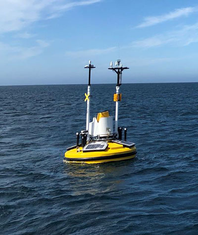
Fugro’s Seawatch lidar buoys will record continuous wind measurements to support wind-resource mapping for Denmark’s Energy Island development. (Photo: Fugro)
Fugro has secured a contract with Energinet to provide floating wind lidar measurements for what an offshore artificial energy island, which is being constructed for the Danish Government.
Fugro will install and operate four SEAWATCH wind lidar buoys at two locations, Energioe Nordsoen and Energioe Baltic, that will act as hubs connecting several offshore wind farms.
Starting this month October, the buoys will record continuous wind measurements for a minimum of one year to support wind-resource mapping for the two islands, and the engineering and design of the future wind farms. Fugro is already performing geophysical surveys for the Energy Island project under a separate contract to provide Energinet with a reliable de-risked site interpretation.
The SEAWATCH wind lidar buoy can record wind measurements up to 250 meters above sea level, and wave measurements and current profiles down to the seabed. The buoy also acts as a multipurpose platform for additional metocean sensors and, on this project, will be fitted with sensors to capture geodata on environmental impact parameters.
Contract for erosion off Indian coast
OCS Services Pvt. Ltd (OCS), one of India’s marine service providers, has awarded Fugro a two-year contract to support its asset integrity and corrosion management operations off the west coast of India.
Fugro will help OCS deliver on ONGC’s Protective Coating of Process Platform Project 1, an infrastructure project to maintain and refurbish 32 offshore platforms in seven clusters. The project is expected to be completed by May 2023.
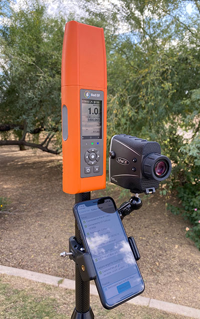
Bad Elf LLC and Laser Tech are providing an integrated laser offset workflow for acquiring high-accuracy field data in GNSS-challenged environments.
The new workflow integrates Bad Elf and LTI hardware in collaboration with ArcGIS technology from Esri.
The Bad Elf Flex GNSS receiver connects to any LTI TruPulse rangefinder over a wired or Bluetooth connection to deliver high-accuracy location data to Esri ArcGIS Field Maps. Field workers can now efficiently complete position and height data collection in access-limited situations, saving time, money and effort, the companies said.
“This collaborative integration effort empowers field data collectors to focus their time, energy, and budget on creating and maintaining their systems of record, instead of troubleshooting systems integration issues,” said Larry Fox, vice president of marketing and business development at Bad Elf. “As Esri Partners in the Esri Partner Network, we are pleased to collaborate with LTI in offering a straightforward workflow to our customers.”
“The ability to capture height measurements of an asset expands the data collection capabilities and ability to add more attribute data to the remote asset,” said Derrick Reish, senior product manager at Laser Tech.
Bad Elf’s app workflow focuses on enhancing productivity, reducing field collection difficulties, and mitigating quality issues. The Bad Elf app workflow runs on Android and iOS. Connection versatility minimizes operating system limitations and allows for app-based or standalone operation. Bad Elf also provides free Esri ArcGIS Desktop and ArcGIS Pro tools for offset-enabled point feature capture using the currently available ArcGIS Field Maps for iOS.
“The Bad Elf Flex, when paired with an LTI TruPulse rangefinder and ArcGIS Field Maps, delivers a powerful data collection solution,” said Esri Product Lead Jeff Shaner. “The innovative checklist-driven workflow delivers an intuitive, streamlined experience for advanced field workflows and the ability to provide a height calculation unlocks new opportunities for data capture.”
Swift Navigation has been named Fleet Management Technology Company of the Year in the second annual AutoTech Breakthrough Awards conducted by AutoTech Breakthrough.
AutoTech Breakthrough is a market intelligence organization that recognizes the top companies, technologies and products in the global automotive and transportation technology markets.
Swift offers a highly-accurate, highly-reliable precise positioning solution that improves the operational efficiency of commercial transport, long-haul trucking and last-mile delivery, whether human-driven or autonomous. Swift’s fleet management precise positioning solution is comprised of the Skylark precise positioning service—delivering continent-wide, cloud-based corrections service — and the receiver-agnostic Starling positioning engine, which works with a variety of automotive-grade GNSS chipsets and inertial sensors, making centimeter-level GNSS accuracy a possibility without the cost of all new equipment.
Swift’s precise positioning solution delivers improved GNSS accuracy to make it easier to enable key fleet management capabilities such as lane-level analytics, route optimization and accurate traffic flow analytics to improve operational efficiency.
Sandia National Laboratories scientist Peter Schwindt, left, and postdoctoral scientist Bethany Little examine the vacuum package held in a yellow, 3D-printed mount. (Photo: Bret Latter/Sandia)
The compact, fieldable device could provide means to navigating without GPS
News from Sandia National Laboratory
Don’t let the titanium metal walls or the sapphire windows fool you. It’s what’s on the inside of this small, curious device that could someday kick off a new era of navigation.
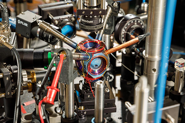
For more than a year, the avocado-sized vacuum chamber has contained a cloud of atoms at the right conditions for precise navigational measurements. It is the first device that is small, energy-efficient and reliable enough to potentially move quantum sensors — sensors that use quantum mechanics to outperform conventional technologies — from the lab into commercial use, said Sandia National Laboratories scientist Peter Schwindt.
Sandia developed the chamber as a core technology for future navigation systems that don’t rely on GPS satellites, he said. It was described earlier this year in the journal AVS Quantum Science.
Countless devices around the world use GPS for wayfinding. It’s possible because atomic clocks, which are known for extremely accurate timekeeping, hold the network of satellites perfectly in sync.
But GPS signals can be jammed or spoofed, potentially disabling navigation systems on commercial and military vehicles alike, Schwindt said.
Instead of relying on satellites, Schwindt said future vehicles might keep track of their own position. They could do that with onboard devices as accurate as atomic clocks, but that measure acceleration and rotation by shining lasers into small clouds of rubidium gas like the one Sandia has contained.
Atomic accelerometers and gyroscopes already exist, but they’re too bulky and power-hungry to use in an airplane’s navigation system. That’s because they need a large vacuum system to work, one that needs thousands of volts of electricity.
A compact device designed and built at Sandia National Laboratories could become a pivotal component of next-generation navigation systems. (Photo: Bret Latter/Sandia)
“Quantum sensors are a growing field, and there are lots of applications you can demonstrate in the lab,” said Sandia postdoctoral scientist Bethany Little, who is contributing to the research. “But when you move it into the real world, there are lots of problems you have to solve. Two are making the sensor compact and rugged. The physics takes place all in a cubic centimeter (0.06 cubic inches) of volume, so anything larger than that is wasted space.”
Little said her team has shown that quantum sensing can work without a high-powered vacuum system. This shrinks the package to a practical size without sacrificing reliability.
Instead of a powered vacuum pump, which whisks away molecules that leak in and wreck measurements, a pair of devices called getters use chemical reactions to bind intruders. The getters are each about the size of a pencil eraser so they can be tucked inside two narrow tubes sticking out of the titanium package. They also work without a power source.
To further keep out contaminants, Schwindt partnered with Sandia materials scientists to build the chamber out of titanium and sapphire. These materials are especially good at blocking out gasses like helium, which can squeeze through stainless steel and Pyrex glass. Funding was provided by Sandia’s Laboratory Directed Research and Development program.
Construction took sophisticated fabrication techniques that Sandia has honed to bond advanced materials for nuclear weapons components. And like a nuclear weapon, the titanium chamber must work reliably for years.
The Sandia team is continuing to monitor the device. Their goal is to keep it sealed and operational for five years, an important milestone toward showing the technology is ready to be fielded. In the meantime, they’re exploring ways to streamline manufacturing.
Sandia National Laboratories is a multimission laboratory operated by National Technology and Engineering Solutions of Sandia LLC, a wholly owned subsidiary of Honeywell International Inc., for the U.S. Department of Energy’s National Nuclear Security Administration. Sandia Labs has major research and development responsibilities in nuclear deterrence, global security, defense, energy technologies and economic competitiveness, with main facilities in Albuquerque, New Mexico, and Livermore, California.
Companies to develop an industry cloud to enable construction organizations to harness digital construction data across the project lifecycle
Trimble and Microsoft have entered a strategic partnership to advance technology adoption and accelerate the digital transformation of the construction, agriculture and transportation industries.
By leveraging the Microsoft cloud, Trimble and Microsoft will collaborate to develop, build and deliver industry cloud platforms and solutions that connect people, technology, tasks, data, processes and industry lifecycles. The collaboration represents a significant milestone to advance Trimble’s Connect and Scale 2025 strategy, which centers on building cloud platforms.
Initially, Trimble and Microsoft will focus on building the Trimble Construction Cloud powered by Microsoft Azure.
Image: Trimble
The construction process is fragmented, which can result in lost productivity, rework and a lack of transparency. According to a McKinsey & Company article*, the construction industry is lagging with only 1 percent productivity growth over the last 20 years — significantly lower than the 2.8 percent for the total economy.
Digitization of products and processes is expected to drive change in the industry. The ability to link technologies, tasks, processes and multiple stakeholders — general contractors, subcontractors, designers, engineers and owners — across the construction project workflow can transform and significantly improve productivity, quality, safety, transparency and sustainability, according to Trimble.
The partnership expands Trimble and Microsoft’s existing relationship to combine the Microsoft cloud with Trimble’s construction solutions and industry domain knowledge. Trimble’s construction solutions include on-machine and field technology, modeling and collaboration software, project and resource management, and all underlying analytics.
The Trimble Construction Cloud, expected in 2022, will be fully enabled for 3D constructible models that will reduce risks, drive speed and increase efficiency and accuracy across the construction project lifecycle, including designing, building and operations.
The companies will also partner on go-to-market strategies and solutions to enable continued support of infrastructure investment cycles, and be used for large-scale projects, on which multiple stakeholders work in parallel to deliver connected construction projects.
Up to five-year contract follows a successful pilot program that demonstrated the value of commercial RF geospatial intelligence
HawkEye 360 has been awarded a contract by the National Geospatial-Intelligence Agency (NGA) to help the agency discover, characterize and map activities that emit energy in the radio frequency (RF) bands of the electromagnetic spectrum.
HawkEye 360 specializes in RF data and analytics from space-based satellites.
HawkEye 360 will provide NGA the means to develop global datasets, enabling users to discover and monitor a broad range of RF activity across large geographic areas.
The $10 million one-year contract includes an option for four more years. It will support users throughout the NGA enterprise, including the combatant commands and other mission partners.
HawkEye 360’s data will support a variety of analytics missions for NGA, including military activity and the trafficking of military, nefarious, non-state and transnational criminal (or illicit) activity. The company’s growing constellation of satellites will provide insight into developing events in a timely manner, and the company will work collaboratively with NGA on an ongoing basis to effectively meet the agency’s mission needs.
“We’re pleased to be moving from the pilot into an NGA long-term operational contract, which showcases the value of unclassified, shareable commercial RF insights,” said HawkEye 360 CEO John Serafini.
“This program is an excellent example of agile acquisition rapidly delivering high-impact GEOINT to the warfighter,” said Alex Fox, the company’s executive vice president for business development, sales and marketing.
NGA leveraged a National Reconnaissance Office commercial integration study contract with HawkEye 360 in September 2020 to execute a test and evaluation contract with the company.
NGA then issued a competitive RFP in March 2021 and awarded the contract in July 2021. “We are excited to continue working with NGA to address current mission requirements and expand the RF GEOINT tradecraft to address an even larger set of mission requirements, much like NGA has done with their pioneering use of commercial imagery,” Fox said.
HawkEye 360 operates a constellation of nine RF-monitoring satellites. Twenty-one additional satellites are fully funded and scheduled for launch in 2021 and 2022. Once complete, this baseline constellation of 30 satellites will provide collection revisits as frequently as every 20 minutes.
Following the establishment of the baseline constellation, HawkEye 360 plans to launch a second-generation constellation of 30 additional satellites by 2025 to satisfy projected capacity and operational requirements.
The company’s RF data and analytics produce actionable insights for national, tactical and homeland security operations, maritime domain awareness, environmental protection and a growing number of new defense and commercial applications.
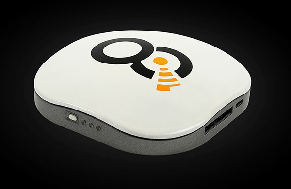
OQ’s dual-mode satellite-cellular IoT terminal can collect data from more than 1,000 sensors, has built-in GPS, and supports 5G NB-IoT, GSM, LTE-M and bi-directional satellite links. (Photo: OQ Technology)
5G satellite operator OQ Technology has successfully completed the in-orbit commissioning (IOC) of its Tiger-2 nanosatellite, and is ready to begin customer demonstrations. The company will start commercial services for “latency-tolerant” low-power devices in 2022.
OQ Technology started the IOC phase on Aug. 15, conducting operations to verify the performance of the satellite’s payload, which worked flawlessly on both uplink and downlink.
OQ also tested and calibrated its terminals in different fixed and mobile environments in the desert and for indoor usage. During tests, OQ was able to send the terminal’s location, as determined by its internal GPS receiver, to the satellite from inside a fast-moving car without having a direct line of sight to the sky.
When buried in desert sand, the terminal still sent signals to the satellite, making it suitable for many agricultural applications.
Over the next few years, OQ Technology is planning to launch a constellation of 72 satellites, providing 5G internet of things (IoT) and machine-to-machine communication. Its “cell-tower inside the satellite” technology is designed to provide real-time global connectivity with reliable low latency communication.