The Galileo High Accuracy Service (HAS) was tested under real farming conditions to assess its performance and suitability for precision agriculture
The European GNSS Service Centre (GSC) of the European Union Agency for the Space Programme (EUSPA) partnered with Hemisphere GNSS and Case New Holland to test the suitability of the Galileo HAS service for precision agriculture.
The tests were performed at the New Holland campus in Peñarrubias del Pirón, Segovia, Spain.
The working width used for the test was 2.55 m, while the test area covered approximately 20,000 m² with a perimeter of about 740 meters. During the three-hour test, the teams collected GNSS data to analyze the pass-to-pass and absolute accuracy metrics. Pass-to-pass accuracy is the relative precision of a guidance system to maintain a consistent distance between adjacent, parallel machine passes within a short timeframe (usually 15 minutes). It is crucial for reducing gaps and overlaps during planting, spraying, and harvesting.
Test campaign
The test campaign aimed at proving that the tractor consistently maintained the specified path accuracy during consecutive passes. This would show that HAS can optimize agricultural operations by reducing costs associated with overlaps (reworking the same area), leading to savings such as reduced fuel consumption, minimal input waste, and improved crop yield.
For the test setup, in addition to the onboard guidance system, an independent antenna was mounted on the tractor cab. This antenna was connected to two positioning solutions: one based on the Galileo HAS and another based on an RTK solution.
An RTK base station deployed for the occasion provided the rover with precise RTK corrections and enabled generating a “reference path” against which to compare the tested Galileo HAS, in this case based on corrections obtained directly from the signal in space (SIS) via the Galileo E6 band.
The driving was performed in automatic mode, with manual intervention required only for turning at the end of each pass. The autosteering system of the tractor would then automatically reconnect with the following path, as calculated at start-up.
Test results
The test began with the GNSS receiver in Cold Start mode, requiring it to obtain ephemerides and process satellite data before achieving precise positioning. The convergence time was calculated and is shown as the red area in the image below. The green area shows when the tractor started along the predefined paths and hence when the data was used for the pass-to-pass accuracy calculation.
Converge time and data set during the test. (Credit: EUSPA)
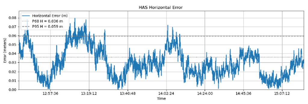
The data analysis showed that the Galileo HAS system consistently maintained horizontal errors of 3-6 cm.
With a 95% horizontal error of 5.9 cm and its maximum value below 8 cm, the error remains well below the 20 cm HAS accuracy target.
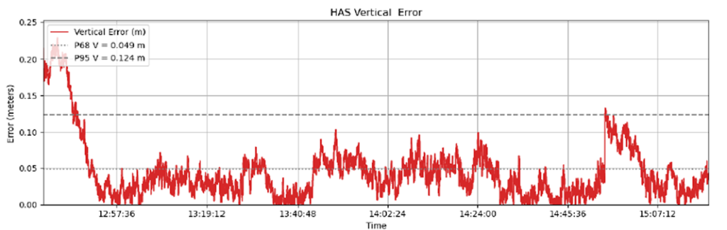
As regards the vertical axis, the 95% vertical error was 12.4 cm, with its maximum value below 25 cm, (remaining well below the 40 cm HAS accuracy target).
Galileo HAS signal vertical error. (Credit: EUSPA)
The horizontal error of the HAS service relative to the RTK reference baseline is shown in the following figure.
Galileo HAS signal horizontal error. (Credit: EUSPA)
Regarding the pass-to-pass accuracy, the analysis shows an overall pass-to-pass accuracy of 1.18 cm, demonstrating highly stable performance throughout the test period.
Year-to-Year accuracy was not part of this testing campaign but will be analysed in the next testing campaign.
Galileo HAS potential confirmed
The Galileo HAS service is an open, standardized correction service distributed directly via Galileo E6 or the internet (with global coverage) and the test campaign results confirm its potential to generate savings to farmers in terms of fuel consumption, fertilizers, seeds and other inputs, by reducing overlap in field operations.
The rapid growth of autonomous military systems is creating a new challenge for the defense industry, working to keep equipment operating when navigation becomes unreliable.
Across recent conflict zones and contested regions, GNSS disruption is affecting UAVs, loitering munitions, ISR platforms, maritime systems and autonomous ground vehicles.
“InfiniDome is expanding its vision beyond GNSS protection, toward a future of mission continuity and navigation awareness in contested environments,” the company stated.
The statement reflects a broader trend across the defense autonomy sector. While anti-jamming technologies were once treated primarily as protective add-ons, many military programs are now integrating navigation resiliency into wider autonomy architectures. The result is a growing shift in how autonomous systems are evaluated.
Rather than focusing solely on navigation accuracy or platform performance, defense organizations are increasingly asking whether autonomous systems can maintain operational continuity under degraded or denied conditions. Industry observers note that this transition is particularly evident in the loitering munition and tactical UAV sectors, where survivability in contested environments is becoming a baseline operational requirement.
At the same time, low-SWaP anti-jamming capabilities are becoming more common across the market, increasing pressure on companies to differentiate beyond hardware alone. That pressure appears to be accelerating a broader industry movement toward what some describe as “navigation awareness,” the ability not only to withstand interference, but also to understand and react to the electromagnetic environment in real time.
InfiniDome is expected to demonstrate this direction during the exhibition through IroNav, developed jointly with Wonder Robotics. The demonstration will include autonomous operation streamed live from a jammed environment in Israel, showcasing navigation resilience capabilities under active interference conditions.
The live demonstration comes as European defense programs continue increasing investments in autonomy, tactical drones, and resilient battlefield systems amid growing concerns surrounding electronic warfare and GNSS vulnerability.
As GNSS interference becomes more common and sophisticated across defense and mission-critical operations, resilient systems are now a core design priority.
At Jammertest in Andøya, Norway, industry participants evaluated how GNSS technologies perform under realistic interference conditions designed to replicate operational challenges faced in the field. Among them was Septentrio, which used the event to assess resilience strategies, explore emerging threat scenarios and showcase its latest advancements in anti-jamming and anti-spoofing technology.
GPS World spoke with Septentrio product manager, Yasmine Hunter, about Jammertest, the growing complexity of GNSS-denied environments and the company’s newly introduced mosaic-G5 P8 receiver designed for SWaP-sensitive, mission-critical applications operating in contested environments.
Jammertest and Real-World Scenarios
How realistic are the Jammertest scenarios, and how closely do they reflect real-world GNSS interference challenges?
I would say quite realistic. One of the strengths of Jammertest is that participants can actively propose scenarios based on what we have encountered in the field, and organizers are often able to adapt to those. For us, this means providing feedback on settings/scenarios that we have seen with our customers.
In addition, it offers participants the opportunity to test the equipment under real environmental conditions. Propagation conditions, terrain, platform dynamics, and antenna behavior (including multipath) all play major roles. These factors significantly influence GNSS performance and are very difficult to fully replicate in a laboratory, so testing them in an operational environment adds a lot of value.
To what extent do these scenarios mirror conditions in conflict zones (e.g., the Middle East or Ukraine)?
In my view, it’s very difficult to fully replicate a conflict‑zone environment, even in a remote location like Andøya. Conflict zones involve a unique combination of sustained, coordinated interference, evolving tactics, and operational pressure that is hard to mirror exactly.
Jammertest allows us to explore individual elements of those environments in a controlled and repeatable way and bridges lab and real‑world deployment by exposing systems to realistic threat profiles without the unpredictability and risk of an active conflict zone.
What are the biggest takeaways from Jammertest?
One clear takeaway is that jamming and spoofing scenarios are becoming more complex and sophisticated every year. It’s increasingly challenging as GNSS manufacturers to address these threats in isolation and still ensure robust operation across real-world use-cases.
Which brings me to the second point; resilience is not only about maintaining position availability. Situational awareness – understanding what the receiver is experiencing and why – becomes increasingly critical. Knowing when GNSS can be trusted, and when it cannot, is just as important as maintaining a solution.
What does Septentrio do differently from competitors when it comes to mitigating jamming and spoofing?
Septentrio has been working on jamming and spoofing mitigation for a long time, and that experience is built on extensive real‑world use cases rather than purely theoretical approaches.
This means that our receivers have been designed to be resilient, not just at the signal processing level, but also in how they disseminate this information to users. From my application‑engineering background, I’ve seen that these two aspects are equally important: strong mitigation technologies and clear insight into what is happening so users can make informed decisions.
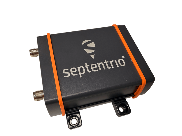
The mosaic-G5 P8 offers trustworthy positioning and seamless switching to alternative sensors during GNSS disruptions. (Photo: Septentrio)
What are some of the most significant engineering or design challenges in developing resilient GNSS solutions?
A key challenge is balancing performance, robustness, and usability. Advanced mitigation techniques often come with trade‑offs in complexity, power consumption, or cost. As we are targeting increasingly SWaP‑sensitive applications with our latest modules, this balance becomes especially critical and requires careful design decisions from the outset.
From a usability perspective, it’s not just about rejecting interference or spoofing, but also doing so in a way that preserves continuity and transparency (or trust) in the solution that we provide.
How is your approach evolving as interference becomes more sophisticated?
We increasingly accept that GNSS will rarely operate alone in challenging environments. The focus is shifting toward deeper integration with complementary sensors and systems.
From our side, that means ensuring the GNSS receiver provides reliable, high‑quality information — not just position — but also integrity metrics and interference indicators (like our jamming and spoofing flags) that other systems can use effectively. Understanding how GNSS fits into a broader navigation or mission architecture is becoming essential.
Upcoming Product Releases in the Defense Market
Can you provide an overview of the new product and the specific problem it is designed to solve?
The mosaic-G5 P8 introduces what we call “ultimate resilience”. It is targeted to mission-critical applications where optimizing not only availability, but also the integrity of the solution is the main goal.
The product directly addresses environments where GNSS interference is not occasional but expected — and where incorrect positioning data can be more dangerous than no data at all.
What are the key technical specifications or innovations that set this product apart?
It has the highest level of jamming rejection and combined with more advanced spoofing mitigation capabilities. In addition, the mosaic-G5 P8 provides access to synchronized baseband samples and jamming-power indicators. These outputs enable advanced use cases such as jammer detection and localization.
How does this solution improve performance in contested or denied environments?
It improves both availability and integrity. The receiver is designed to maintain a usable solution for as long as possible, while also clearly indicating when conditions degrade. This allows operators or higher‑level systems to react appropriately.
What types of platforms or use cases is this product best suited for (e.g., UAVs, ground vehicles, naval, etc.)?
We are primarily targeting SWaP‑sensitive, mission‑critical platforms. So far, we’ve seen strong adoption (of our other products) in highly mobile applications such as UAVs and USVs, but we see clear potential across a broader range of platforms, including ground and (other) maritime systems.
How does it integrate with existing systems or architectures?
The receiver is designed to integrate seamlessly into existing architectures through standard interfaces, while also offering advanced outputs for customers who want deeper system‑level integration. This flexibility allows it to serve both as a drop‑in GNSS solution and as an active sensor within a larger resilience framework.
How does this launch reflect broader trends or priorities in the defense GNSS market?
It reflects a clear shift toward resilience, integrity, and transparency rather than pure accuracy. Defense users increasingly recognize that GNSS denial is not an edge case, but a baseline assumption. Solutions must therefore be designed to operate, inform, and adapt under persistent interference and spoofing.
Looking Ahead
What should defense and industry stakeholders be preparing for now?
They should be preparing for a reality in which GNSS interference is persistent, adaptive, and increasingly deliberate—not an exception, but an operating condition.
This is also an aspect we are actively considering with solutions like the mosaic‑G5 P8. Rather than treating resilience as a theoretical requirement or a nice add-on, we’re designing for operational use cases where integrity, interference awareness, and transparent behavior under stress are essential.
For stakeholders, this means thinking beyond standalone receivers and focusing on system‑level architectures: how GNSS integrates with other sensors, how integrity information is consumed, and how platforms respond when GNSS performance degrades.
The AsteRx EB offers high-accuracy positioning and GNSS heading for industrial robots, port logistics, marine and scalable automation applications. Its IP67 enclosure protects the receiver from harsh weather conditions, while built-in advanced GNSS+ algorithms ensure reliable operation in environments challenging for GNSS, such as areas with foliage or near GNSS interference sources. The RAIM+ integrity monitoring system ensures truthful positioning — essential for autonomous navigation. The compact enclosure of AsteRx EB enables easy installation, reducing time-to-market. In a dual-antenna configuration, AsteRx EB delivers sub-degree GNSS heading for systems that require orientation in addition to RTK positioning. The built-in AIM+ anti-jamming and anti-spoofing technology protects the receiver from intentional or unintentional GNSS interference.
The Facet FP is a high-precision GNSS receiver designed to deliver centimeter-level accuracy with a focus on long-term flexibility, ease of use and open-source innovation. It combines multi-band, multi-constellation GNSS support with fully open-source firmware — the platform can adapt as technologies advance. Built to last, all models are contained in a robust waterproof cast-aluminum housing, with an internal structure designed for compatibility with the company’s Flex system of GNSS modules. This gives users the choice between three different modules, plus the choice of having tilt-compensation, offering six different options with a range of price points, securities and accuracies for various needs and applications.
The A65 GNSS antenna delivers exceptional accuracy, interference protection and robust GNSS tracking performance. Designed as a drop-in replacement for the widely deployed A45 antenna, the A65 offers users a seamless upgrade path to the latest precision technology. The industry collaboration reflects a shared focus on combining advanced RF design with real-world application insight to address increasingly complex GNSS operating environments, with both teams working closely from the earliest stages of development to meet demanding original equipment manufacturer (OEM) performance requirements. The antenna architecture, including the stacked patch quad feed element and RF front end, provides Calian’s XF Filtering. Hemisphere GNSS contributed application expertise, system integration requirements and performance validation within real-world machine control, agriculture, marine and survey environments.
Airborne Lidar
Long-range for UAV mapping and aerial surveillance
AlphaAir 6 is mounted on the X500 UAV during an urban mapping mission. (Credit: CHC Navgation)
The AlphaAir 6 airborne lidar system is designed for UAV-based laser scanning, drone lidar mapping and aerial surveying in high-relief and complex terrain. Combining prism scanning technology with a high-grade inertial navigation system (INS), the AlphaAir 6 delivers a maximum ranging capability of up to 2,100 m and supports efficient data capture at typical flight altitudes of 400 m to 600 m above ground level. It integrates an upgraded laser engine and a high-grade IMU with 0.3°/h bias stability to improve trajectory accuracy and point cloud quality. This design removes the need for pre-mission IMU calibration and supports stable, efficient data collection for topographic mapping, corridor mapping, and wide-area aerial survey workflows. It is available in single-camera and dual-camera configurations.
The FastXY mapping application for iOS and Android enables standard mobile devices to serve as professional-grade data-collection tools for geospatial information system (GIS) and architecture, engineering and construction (AEC) professionals. FastXY allows users to collect point, line and polygon data with devices they already own. It delivers advanced capabilities including 3D basemaps, construction staking, topographic surveying, on-the-fly datum transformations, and survey-grade elevations. A built-in Bluetooth data parser allows users to configure the app to collect data from any instrument supporting BLE Bluetooth or RS-232 — echosounders, radiation sensors, laser rangefinders, barcode scanners — and marry that data with precise GNSS coordinates.
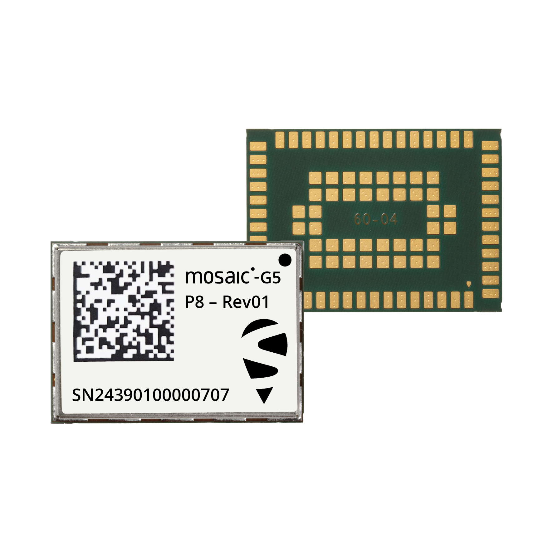
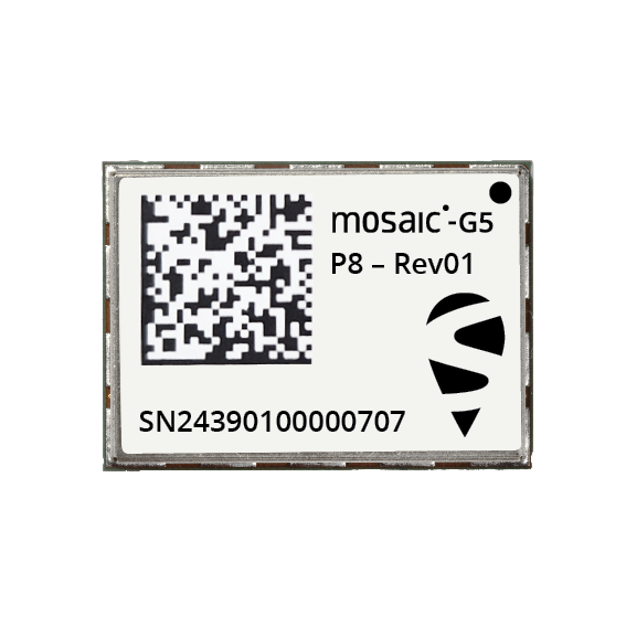
Septentrio, part of Hexagon, has announced the launch of the mosaic-G5 P8 receiver. The multi-frequency module, measuring 23 mm by 16 mm and weighing 2.2 grams, enables accurate and resilient positioning without any performance compromises for mission-critical devices, UAVs, marine vessels, and rail applications.
Built for reliable operation in contested GNSS environments, AIM+ Ultimate technology protects the receiver from powerful and sophisticated GNSS jamming and spoofing attacks. It delivers comprehensive situational awareness, combining timely interference and spoofing indicators with detailed power and frequency data, which can help localize jammers.
“The mosaic-G5 P8 is in a class of its own: uncompromised GNSS resilience in a secure, ultra‑compact, all‑in‑one design,” said Yasmine Hunter, product manager at Septentrio.
The newly released module features an integrity-focused design that ensures truthful positioning and reporting, enabling the system to quickly switch to other sensors during GNSS disruptions in heavily compromised environments. Secure communication with input and output authentication prevents unauthorized access and data interception. mosaic-G5 P8 also offers high update rate with low latency, supporting reliable navigation and control in highly dynamic applications.
The module is compatible with widely used, open-source autopilots like PX4 and ArduPilot, simplifying drone integration. The mosaic-G5 P8 evaluation kit, featuring direct autopilot connections, is available for testing and prototyping, and the RxTools user interface streamlines setup and evaluation.
Meet Septentrio’s GNSS experts and mosaic-G5 P8 during SOF Week in Tampa, Florida, May 18–21, in booth #609.
In a move to enhance maritime security and operational safety, global maritime organization have released on May 20 new guidance for ships transiting the Strait of Hormuz, reports Shipping Telegraph.
The 22-page guidance document — “Industry Guidance on the Safe Management of Vessel Transit through the Strait of Hormuz” — aims to assist in planning and safely managing vessel transits into, within or out of the Gulf region during periods of heightened regional security risk.
Thedocument was issued jointly by major industry organisations including International Chamber of Shipping (ICS), BIMCO, Intercargo, Intertanko, IMCA and OCIMF
Vessels may face a high workload and high-stress operating environment, including GNSS jamming or spoofing.
TrustPoint has been awarded a $4 million Tactical Funding Increase (TACFI) contract to demonstrate a GPS-independent positioning, navigation and timing (PNT) system.
The award was issued by SpaceWERX, the innovation arm of the United States Space Force, and jointly funded by the Small Business Innovation Research (SBIR) program and the Commercial Space Office (COMSO). It supports a full end-to-end demonstration of TrustPoint’s resilient navigation architecture designed for defense and commercial applications.
Under the contract, TrustPoint will design, deploy and operate a fully integrated PNT system comprising four satellites and four ground stations, delivering a complete operational architecture. The program will execute an end-to-end system demonstration, including live trilateration across multiple space and ground assets, operational services and advanced receivers.
With an accelerated execution timeline, initial system deployments will occur within 12 months, establishing a rapid deployment model designed to scale to significantly larger constellations while prioritizing affordability, operational relevance, and capital efficiency.
“We founded TrustPoint on the belief that resilient navigation does not require billion-dollar constellations,” said Patrick Shannon, founder and CEO of TrustPoint. “This program will prove our technology’s GPS independence while demonstrating that real, operational PNT capability can be delivered with exceptional capital efficiency.”
Beyond GPS-independent C-band demonstrations, the system will validate a software-defined architecture that supports on-demand reconfiguration of navigation services in contested, degraded and denied environments, pioneering commercial delivery of this capability. TrustPoint’s experience includes the first C-band GNSS signal transmission with real-time reception and the first broadcast-based ground-to-space C-band PNT demonstration.
The program directly advances national security objectives. It also establishes a scalable foundation for future commercial services, redefining what is possible for users who require reliable PNT in GPS-challenged environments.
Norwegian insurer DNK will provide members with assured positioning, navigation and timing (A-PNT) services using Iridium Communications’ low-Earth orbit satellite network. DNK, Den Norske Krigsforsikring for Skib, specializes in war-risk insurance.
The new program allows its clients to select systems from specialized technology vendors to protect against GNSS interference while qualifying for insurance premium rebates.
The framework aligns with DNK’s aim of using digital technologies to safeguard Norwegian-owned or controlled vessels from war, terror, piracy and cyberattacks.
“Over the past five years, we have seen a sharp increase in GNSS interference, especially in the Black Sea, the Baltic Sea and more recently, in the Persian Gulf and Red Sea,” said Svein Ringbakken, CEO at DNK.
“GNSS signal interference can not only increase the risk of collision or grounding but also compromise critical safety systems. This program offers our members the opportunity to lower premiums by investing in cost-effective A-PNT solutions to maintain situational awareness, safety and positioning integrity.
“This program will not only help members lower premiums and ensure the safety of their vessels but help us collect data we can share with owners, managers and other stakeholders operating in known and emerging conflict zones.”
DNK evaluated alternative positioning frameworks based on Iridium’s global network of 66 low-Earth orbit (LEO) satellites. The vendors participating in the program offer subscription-based hardware systems with a configuration including an Above Deck Unit that transmits jamming and spoofing telemetry back to DNK, alongside an optional Below Deck Unit that provides real-time situational awareness directly to the vessel crew.
“GNSS jamming and spoofing not only compromise situational awareness, the intentional manipulation of positioning data can also lead vessels into sanctioned or restricted zones,” said Alan Belardinelli, Project Manager at DNK. “After extensive research, DNK found that the Iridium signal, which is 1,000 times more powerful than GNSS signals, is significantly more difficult to disrupt, adding a significant layer of enhanced positioning resilience. Signal attacks can also play havoc with onboard digital systems that rely on GNSS to provide a source of timing, necessary for safe navigation and efficient operations.”
The project has received formal support from Norwegian authorities, represented by Marianne Sivertsen Næss, Minister of Fisheries and Ocean Policy, alongside the Norwegian Shipowners’ Association, represented by Knut Arild Hareide, Chief Executive Officer.
“PNT Iridium stands as a powerful and effective complement to GNSS, ensuring continuity for vessels when traditional signals are degraded or denied,” said Rohit Braggs, vice president of PNT at Iridium. “More importantly, it acts as a resilient ‘source of truth’ by providing assured timing and positioning that maritime systems can depend on, whether in open waters or bustling ports.”
The U.S. Federal Aviation Administration (FAA) has updated its “GNSS Interference Resource Guide.” The FAA’s Flight Technologies and Procedures Division (AFS-400) developed the guide to provide operators and pilots with current information on GPS/GNSS jamming and spoofing. According to the guide, “As the threat of GNSS jamming and spoofing is constantly changing, the FAA will update this resource guide to provide the best guidance in the rapidly changing environments.”
UK scientists unite to uncover coastline mysteries
The research vessel Cefas Endeavour at dock in Lowestoft.(Credit: Cefas)
The UK Centre for Seabed Mapping (UK CSM) conducted a survey to explore and map the seabed along the United Kingdom’s southwest coastline. For four weeks, a team of 26 maritime scientists collected hydrographic, geological and environmental data. According to UK CSM, the survey represents an unprecedented level of collaboration within the maritime sector. The team aimed to collect and share high-quality marine data and make advances in how the seabed is mapped, understood and managed. The findings will support a wide range of applications including offshore energy and infrastructure, marine ecosystem science, safety at sea, marine policy, and defense.
Bangladesh at the top
Credit: MD Maruf Hassan/E+/Getty Images
In April, field teams for the Survey department under the Ministry of Defense conducted field work in the remote hill areas of Bangladesh to determine the highest peak. Surveyors used modern geodetic methods and advanced GNSS technology in the Bandarban district, and followed international standards to determine the height of the country’s highest peak above mean sea level (MSL) with centimeter-level accuracy, including latitude, longitude and elevation.
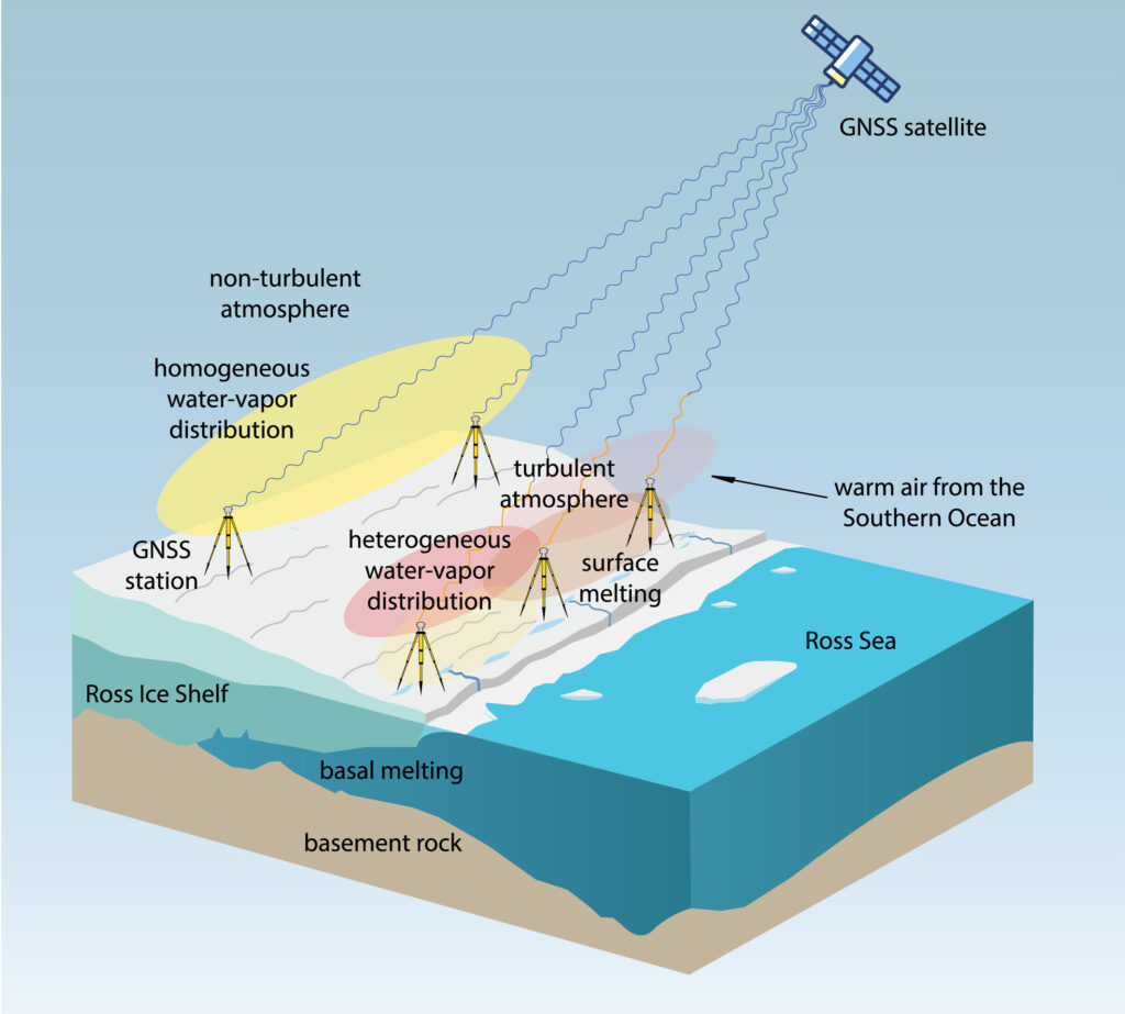
Turbulence shrinks Antartica’s Ross Ice Shelf
Sketch (not to scale) of GNSS sensitivity to atmospheric turbulence in Antarctica (Credit: MIT)
GNSS observations suggest a major melting event at Antarctica’s Ross Ice Shelf was linked to atmospheric turbulence. While the shelf typically melts underneath from warm ocean water, an unusual surface melting episode occurred in January 2016. Researchers from MIT Haystack Observatory used data from existing GNSS stations, with 13 stations installed on the shelf, to examine atmospheric turbulence. Wind, water vapor and temperature variations drawn in by warm and humid air caused the surface to melt, with turbulence four times greater than usual.
ArkEdge Space Inc. has completed a study commissioned by the Japan Aerospace Exploration Agency (JAXA) on “Elemental Technologies and Systems for a Dedicated, GNSS-Independent LEO-PNT Satellite System.”
Positioning, navigation and timing derived from GNSS is increasingly subject to interruption and interference, both through environmental and security challenges. Finding methods to protect PNT information against such interference is of paramount importance for governments and commercial actors alike.
The ArkEdge/JAXA project addressed such challenges by examining and categorizing the necessary elemental technologies — signal design, receiver technology, ground infrastructure, satellite sensors, and the overall system architecture — required to realize a LEO-PNT system capable of providing PNT without reliance on traditional GNSS.
The study’s focus included achieving satellite orbit determination and time synchronization without GNSS, one of the key challenges facing alternative PNT providers. It explored a new architecture for onboard time determination that avoids the need for large atomic clocks. Instead of onboard clocks, the system transmits precise timing information from combinations of ground-based reference clocks, pseudolites and inter-satellite optical links to disseminate information and enable on-orbit ODTS.
Concept art of the LEO-PNT satellite constellation. (Credit: ArkEdge Space)
The study considered diverse frequencies to strengthen anti-jamming measures. It also looked at novel signal design, receivers, encryption and signal authentication methods, and their suitability for LEO-PNT satellites. Results of the study will contribute to the next stage of development for a GNSS-independent LEO-PNT concept.
“This study is critical to advancing our understanding of Japan’s future relationship with PNT,” said ArkEdge Space Chief Strategy Officer Tomoaki Yasuda. “Across the world, users are facing denial of GNSS services, and that can have critical consequences for sectors including the economy, transport and emergency services, among others. We look forward to progressing the GNSS-independent LEO-PNT concept with the support of our partners.”
“Due to the prevalence of GNSS interference, alternative PNT systems are becoming increasingly important to protect users and assets such as critical national infrastructure,” said Masaya Murata, JAXA. “Following the successful conclusion of this GNSS-independent LEO-PNT study with ArkEdge Space, our investigation into a robust and resilient LEO-PNT system continues. We are also emphasizing international cooperation with other LEO-PNT providers to maximize users’ PNT experience and continue to engage in collaborative discussions.”
The addition of 44 antennas to Intuitive Machines’ network is expected to enhance support for customers’ GEO missions and accelerate progress toward Moon base and deep-space operations.
Intuitive Machines Inc. has entered into a definitive agreement to acquire Goonhilly Earth Station Ltd., a deep-space communications provider with major ground station assets in the United Kingdom and Goonhilly USA Inc. (dba COMSAT).
Goonhilly is a provider of lunar and deep space communications services. Since becoming the first commercial provider of these services in 2021, Goonhilly has supported more than 20 missions for space agencies NASA and ESA and private exploration companies, including Intuitive Machines and ispace, representing a vital UK contribution to the international space sector.
In 2024 and 2025, the company played a critical role in Intuitive Machines’ IM-1 and IM-2 lunar missions.
The acquisition will include the Goonhilly Lunar and Deep Space Communications, Commercial Satcom and Defense and Security divisions. It significantly expands global ground-station resources and capacity on Intuitive Machines’ integrated space-to-ground network.
Upon completion of the proposed acquisition, the expanded network is expected to deliver communications, data transport and position, navigation and timing (PNT) capabilities for sustained lunar and cislunar operations.
Goonhilly’s and COMSAT’s civil, commercial and government customers are expected to complement Intuitive Machines’ existing customer base and broaden the Company’s reach into adjacent industries. Upon completion of the acquisition, its strategic UK location will expand visibility across major Earth‑viewing arcs, increasing contact opportunities for lunar and deep‑space missions. With deep expertise in antenna planning, scheduling and station maintenance, Goonhilly’s ground station assets and competencies strengthen Intuitive Machines’ ability to deliver end‑to‑end mission support.
“Customers have been clear that they want a single, integrated, and resilient solution for their communications and PNT needs as they accelerate missions at an unprecedented pace,” said Steve Altemus, co‑founder and CEO of Intuitive Machines. “Our partners of integrated space‑to‑ground network are configured to support missions across LEO, lunar and cislunar environments through a single source for communications, PNT and data transport. Goonhilly will provide the backbone for this network, scales our global ground presence and will bring a strategic core competency to the Intuitive Machines team.”
The Intuitive Machines space-to-ground network combines a lunar data-relay constellation with a global ground segment to maintain persistent line-of-sight communications with the Moon. Goonhilly is expected to enhance this architecture with deep space assets, including the GHY6 32-meter antenna, the cryogenically cooled GHY3 30-meter antenna, and multiband support across X-band, S-band, and Ka-/Ku-band. This will give customers greater flexibility in mission design and more options for communicating with spacecraft throughout lunar and deep space operations.
“Goonhilly has spent years building a world class deep space communications capability,” said Kenn Herskind. Executive Chairman of Goonhilly. “Joining Intuitive Machines will allow us to scale that capability globally and directly support the next era of lunar exploration. Together, we will be creating a commercial lunar communications network that is interoperable, resilient, and ready to support Artemis and international missions.”
The transaction is expected to close in the third quarter of 2026, subject to customary closing conditions, including the receipt of applicable regulatory approvals, including under the UK National Security and Investment Act 2021 and from the U.S. Federal Communications Commission.
Iridium Communications Inc., a provider of global voice, data and positioning, navigation and timing (PNT) satellite services, has entered into a definitive agreement to acquire Aireon LLC.
Aireon is operator of the space-based Automatic Dependent Surveillance-Broadcast (ADS-B) air traffic surveillance system. The acquisition of Aireon is a defining step in Iridium’s strategy to provide the foundational architecture for global aviation safety, bringing space-based surveillance, safety communications, PNT and operational data together on a single network.
“Aireon has always been part of Iridium’s aviation safety strategy. We founded it in partnership with the world’s leading Air Navigation Service Providers (ANSPs), because we believed space-based aviation safety was a generational opportunity,” said Matt Desch, CEO, Iridium. “The aviation industry is now entering an era of growing air traffic, denser airspace, autonomous aircraft, and greater expectations for safety and resiliency. Bringing Aireon fully inside Iridium better positions us to build what’s needed to support the future of aviation, including more innovations like the future introduction of space-based VHF communications.”
Platform for Aviation Safety The acquisition unites Aireon’s surveillance and data services, including GPS jamming and spoofing detection, with Iridium’s global satcom network and PNT services that help keep GPS-dependent systems working in contested environments. This combination creates one company providing four critical aviation industry capabilities: knowing where every aircraft is, communicating with the pilots flying them, providing the navigation and timing integrity those aircraft rely on, and translating that information into operational insights that make airspace safer and more efficient. No other satellite operator delivers this combination of capabilities on a global scale.
The Aireon system, which is certified by theEuropean Union Aviation Safety Agency (EASA), flies as a payload on the Iridium satellite constellation and tracks an average of 190,000 flights per day. Commercial aircraft broadcast information such as an aircraft’s identity, location, altitude, speed, and heading. Aireon’s space-based ADS-B payload captures this information in real time, with 100% global coverage. ANSPs covering more than 50% of the global airspace rely on Aireon data to create safer and more efficient airspace.
The world’s leading ANSPs and investors in Aireon, including NAV CANADA and NATS (United Kingdom), AirNav Ireland, ENAV(Italy), and Naviair (Denmark), each played a vital role in launching the Aireon service, proving its reliability, and establishing it as a critical part of the global air traffic control infrastructure. NAV CANADA and NATS, which together manage the most heavily trafficked oceanic airspace in the world — the North Atlantic Tracks between Europe and North America, were the first to go live with the service. In connection with the acquisition, both ANSPs will sign extended data services agreements through 2035 and beyond, with provisions for continued cooperative development of space-based VHF communications and other new capabilities.
“Aireon and Iridium have been partners since day one, and that partnership is the reason we have been able to build the world’s only space-based air traffic surveillance system and a fast-growing aviation data services business alongside it,” said Don Thoma, CEO of Aireon. “Becoming part of Iridium is a natural next step for our team, our customers, and our roadmap, particularly as our data products expand into new areas like turbulence detection and aviation data analytics. Together, we are building the foundation for the future of global aviation.”
“NAV CANADA is proud of our foundational role in establishing Aireon’s world-first technology,” said Mark Cooper, President and CEO, NAV CANADA. “This sale sharpens our focus on our core expertise: keeping Canada’s skies safe. As a fellow founding partner, Iridium is the ideal owner to guide Aireon’s continued commercial growth. We wish the entire team continued success and look forward to our ongoing relationship as a customer.”
“We have been proud to be a part of Aireon’s successes, most notably making real-time aircraft surveillance over the Atlantic a reality for the first time in history, enabling even safer operations across the North Atlantic,” said Martin Rolfe, CEO, NATS. “As a shareholder for the past eight years, it is now the right time for us to divest. We are confident Aireon is well positioned for the future and wish the team every success in the next stage of its development.”
The Next Transition: Space-Based VHF Space-based VHF communications represent a major opportunity in air traffic management, extending pilot-to-controller VHF services into oceanic and remote airspace where ground infrastructure cannot reach, without the need for additional aircraft equipment. The model is similar to how aircraft already carry ADS-B transceivers, which enables Aireon to deliver space-based ADS-B surveillance without requiring fleet retrofits.
Aireon’s Growing Data Services Business Beyond surveillance for ANSPs, Aireon operates a fast-expanding aviation data services business that sells real-time and historical aviation data to airlines, airports, OEMs, governments, and aerospace operators. Product lines already available or launching this year include turbulence detection, GPS jamming and spoofing detection, and safety and efficiency analytics. Additional applications are also in development to support the rapidly evolving airspace environment.
Aireon’s data business is one of its highest-growth areas today and is expected to be a meaningful contributor to the combined company’s aviation growth.
Terms of the Transaction Iridium is an existing owner of Aireon and will acquire the remaining 61% of equity interests of Aireon in the transaction for a purchase price of approximately $366.7 million from the other owners, NAV CANADA, AirNav Ireland, ENAV, NATS and Naviair. The purchase price will be paid 50% at closing and 50% on the one-year anniversary. Iridium will also assume Aireon’s outstanding debt, expected to be approximately $155 million at closing.
The acquisition of Aireon is accretive to Iridium’s growth outlook; over the past three years, Aireon’s total revenue has grown at a compound annual growth rate (CAGR) of 10%. Iridium expects the acquisition will result in at least an additional consolidated $100 million of service revenue and $30 million of OEBITDA on an annualized basis.
Iridium expects to pay the purchase price with current liquidity, including borrowings under its revolving credit facility, and future cash from operations. After closing the transaction, Iridium expects net leverage to increase to approximately 4.0 times OEBITDA during Q3 2026, with net leverage planned to return to the current levels over the subsequent twelve months. Iridium’s long-term net leverage guide of 2.0 times OEBITDA by the end of the decade remains unchanged and assumes no change in its paused share buyback program.
Aireon will continue business-as-usual operations in the near term, with no planned changes to business strategy. The transaction is targeted to close in early July.
Evercore served as financial advisor and Cooley and Milbank served as legal counsel to Iridium. PJT Partners served as financial advisor and Hogan Lovells served as legal counsel to Aireon.