Blog

  • Septentrio extends GNSS module family with mosaic-G5 P6

    Septentrio extends GNSS module family with mosaic-G5 P6

    Septentrio, part of Hexagon, has launched the mosaic-G5 P6 multi-frequency precise positioning module. The receiver, measuring 23 mm by 16 mm and weighing 2.2 grams, enables reliable positioning without performance compromises for commercial UAVs, robots and other size and power-constrained applications.

    AIM+ Premium technology protects the receiver from sophisticated intentional or unintentional GNSS jamming or malicious spoofing attacks.

    “By extending the mosaic family with mosaic-G5 P6, we are bringing an all-in-one module offering accuracy, resilience, and flexibility for demanding industrial applications,” said Yasmine Hunter, product manager at Septentrio. 

    The newly released module offers one of the highest update rates on the market, combined with low latency, essential for efficient and accurate control systems and navigation. In addition to high-accuracy positioning, raw measurements are also available for high-performance sensor fusion. 

    The mosaic-G5 P6 also offers users the flexibility to balance accuracy and availability and is compatible with Galileo High Accuracy Service (HAS) for decimeter-level positioning out of the box. Users can choose single- or dual-antenna configuration for accurate GNSS heading enabling robust orientation and motion control in industrial automation applications such as autonomous machinery, robotics and precision guidance systems.

    The new module is compatible with widely used, open-source autopilots like PX4 and ArduPilot as well as ROS, simplifying integration into robotic and drone systems. Its evaluation kitsimplifies testing with direct autopilot connections, while the free RxTools user interface assists with the setup and evaluation process.

    Meet our GNSS experts and see mosaic-G5 P6 during Xponential in Detroit, Michigan, May 11–14, at booth #37030. For more information about mosaic-G5 P6 or other Septentrio products, contact the Septentrio team.

  • USX51 flight controller aids UAV development

    USX51 flight controller aids UAV development

    The USX51 Computing Power Flight Controller by UTMSYS is a system architecture that combines the Pixhawk 6X flight controller with the D Robotics RDK X5 edge-computing module.

    According to the development team, the goal of the USX51 platform is not only to provide hardware, but to simplify complex UAV system integration for developers, research teams, and robotics engineers working on real world deployment scenarios.

    The USX51 system integrates Pixhawk 6X and RDK X5 to support PX4-based UAV development for GNSS-denied, VTOL, and multi-sensor applications.

    The system is designed to support PX4-based UAV development while separating real-time flight control tasks from high compute perception workloads. This decoupled architecture helps maintain flight stability while allowing developers to expand into vision based and autonomous applications.

    The USX51 supports development scenarios including:

    • GNSS-denied navigation
    • VTOL mission platforms
    • Multi-sensor integration
    • Visual perception and tracking
    • ROS2-based robotics workflows
    • Research and autonomous UAV development
    Credit: UTMSYS
    Credit: UTMSYS

    The Pixhawk 6X handles flight critical control functions, while the RDK X5 module provides onboard computing capability for visual processing, sensor fusion, and autonomous related workloads.

    The system also provides multiple communication interfaces including Ethernet, CAN, UART and I2C, allowing developers to integrate cameras, thermal modules, lidar systems, and additional peripherals into their UAV projects.

    Current ecosystem development around USX51 includes PX4 integration, ROS2 workflows, developer testing programs, and community based project collaboration.

  • Rohde & Schwarz and Greenerwave achieve fast antenna characterization

    Rohde & Schwarz and Greenerwave achieve fast antenna characterization

    A joint measurement trial, Rohde & Schwarz and Greenerwave have demonstrated that a near-field system can record a full radiation pattern of a 50 cm Ku band electronically steerable array for a SATCOM antenna in a half hour.

    The achieved results match simulation models within a decibel, making this approach a fast and reliable way to verify antenna performance.

    For manufacturers of SATCOM systems facing large chamber constraints, it offers a clear path to quicker, more cost-effective testing. 

    Electronically steerable array (ESA) antennas are becoming key components in modern SATCOM systems. Accurate knowledge of their radiation pattern is required for reliable operation in LEO, MEO and GEO orbits. However, conventional far‑field testing demands chambers that are often larger than practical for Ku or Ka band antennas, especially when the aperture of the Antenna Under Test (AUT) reaches half a meter or more.

    Compact Antenna Test Ranges (CATR), on the other hand, are still relatively large for these AUTs and require time-consuming dual-axis positioning of AUT to map the radiation pattern.

    Rohde & Schwarz and Greenerwave have reached a breakthrough in ESA antenna testing in a joint measurement trial, achieving highly accurate radiation pattern characterization in the near field, significantly reducing measurement time. Greenerwave’s innovative SATCOM user terminals are based on reconfigurable intelligent surfaces (RIS), allowing the company to design electronically steerable antennas that deliver high-performance connectivity while reducing energy consumption and reliance on semiconductors compared with conventional solutions.

    For the joint measurement campaign, Rohde & Schwarz provided its R&S TS8991 over‑the‑air and antenna measurement system, equipped with a conical cut positioner, and its R&S ZNA vector network analyzer. Together, they evaluated Greenerwave’s passive single‑aperture ESA that uses RIS technology for beamforming. The antenna under test (AUT) features a 50 x 50 cm aperture and is designed for low power consumption and easy integration. 

    The measurement covered an extended upper hemisphere down to a polar angle of 120 degrees, using a one-degree step size. Ten Ku band frequencies were recorded in a total of 32 minutes, thanks to the system’s hardware trigger function. Data was processed using the R&S AMS32 antenna measurement software, which applied a FIAFTA near-field-to-far-field transformation algorithm. 

    Comparison with the original simulation based on a numerical twin model and with results from Greenerwave’s CATR setup showed peak gain or directivity variations of max. 1 dB and typically 0.3 dB, validating the accuracy of the near-field solution. Export options allow users to continue analysis in tools such as CST Microwave Studio or MATLAB.

    The trial shows that even large SATCOM antennas can be characterized quickly and accurately with the R&S TS8991 antenna test system from Rohde & Schwarz in a near-field setup, providing a practical alternative to large-sized far-field chambers or CATRs. 

    According to Rohde & Schwarz, the system setup can be used by other SATCOM makers testing broadband, IoT or back haul antennas for applications requiring flexible beam control and high data rates. The setup can be integrated more easily into research lab environments, and it shortens test cycles, reducing overall development cost.

  • SATNUS completes NGWS flight demonstration, validating combat air system development

    SATNUS completes NGWS flight demonstration, validating combat air system development

    The UAV Navigation–Grupo Oesía flight control system, as a subcontractor to SATNUS, proved key to the success of the demonstration.

    In March, the Spanish consortium SATNUS successfully completed the fourth flight demonstration campaign under Pillar 3 of the Next Generation Weapon System / Future Combat Air System (NGWS/FCAS) program, held at the INTA‑CEDEA facilities. The campaign comprised a total of nine flights aimed at verifying the flight control software dedicated to collaborative manned‑unmanned teaming (MUT) operations, led by SATNUS and developed in cooperation with international partners Airbus GmbH and MBDA, and integrated into the Next Generation Autonomy Computer (NGAC). During these tests, the remote carriers were represented by both real and simulated platforms of the manned‑unmanned teaming & common systems demonstrator (MCSD).

    During the campaign, key MUT functionalities were demonstrated, including formation flight, evasive maneuvers, collaborative navigation, mission replanning and formation breakup, among other capabilities. Flights involved up to three real Remote Carriers operating simultaneously, supported by UAV Navigation–Grupo Oesía’s technological contribution in guidance, navigation and control (GNC) systems, which acted as a key enabler for the safe execution of the flight maneuvers carried out within the objectives defined by SATNUS under Pillar 3 of the NGWS/FCAS program.

    The campaign concluded with the execution of flights 29, 30, and 31, in the presence of the Combined Project Team (CPT) and representatives from the National Program Offices of the three participating nations: Spain, France and Germany.

    Engineering teams from all SATNUS partner companies, including members from UAV Navigation–Grupo Oesía, carried out highly specialized work to achieve this milestone, successfully meeting all established objectives. In this context, UAV Navigation–Grupo Oesía’s contribution supported the proper execution of operations and helped validate the capabilities demonstrated throughout the campaign.

    SATNUS has expressed its appreciation for the support and trust of the Spanish Armed Forces and the Spanish Ministry of Defence throughout the entire process and will continue advancing the development of capabilities within other NGWS/FCAS-related programs.

  • AirData UAV joins the Commercial Drone Alliance ahead of Part 108 adoption

    AirData UAV joins the Commercial Drone Alliance ahead of Part 108 adoption

    The U.S. commercial drone industry is at an inflection point. After years of incremental progress, the FAA’s landmark Part 108 Beyond Visual Line of Sight (BVLOS) rule is expected to take effect later this year, unlocking a new era of scaled commercial drone operations across delivery, infrastructure inspection, public safety, perimeter protection and beyond. It’s a pivotal moment for drone operators to get ahead of the most significant regulatory shift the commercial drone industry has seen.

    Today, AirData UAV announced it is joining the Commercial Drone Alliance (CDA), bringing its operational platform into the industry’s broadest coalition for drone policy and progress. As a member of the CDA, AirData will actively contribute to the policies and standards that will define the next chapter of the U.S. drone economy through the CDA.

    Part 108 introduces sweeping new operational requirements across pre-, during and post-flight documentation, personnel roles, risk-categorized operational areas, and mandatory continuous data reporting, and AirData’s platform is already built to meet them.

    “We are at a critical moment for the drone economy,” said Lisa Ellman, Chief Executive Officer of the Commercial Drone Alliance. “As the industry moves toward broader BVLOS operations and frameworks like Part 108, access to scalable, reliable operational data such as that which AirData provides will help to safely unlock the full potential of the drone economy.”

    Credit: AirData UAV

    AirData’s platform delivers the tools operators will need to meet Part 108’s requirements, including: checklists, automated compliance documentation, flight logging across every mission, and fleet-wide analytics that give program managers visibility into operational risk. With more than 61 million flights across 450,000 pilots and 850,000 drones globally, AirData has been building the compliance infrastructure the industry now needs.

    As the industry’s leading policy advocate, the CDA has been central to advancing the regulatory frameworks. The CDA is an independent non-profit organization led by key members of the commercialdrone industry. It works to educate policymakers and the public on the safe integration of drones into the national airspace and to advocate for policies that enable commercial drone operations.

    “We have long served as the intelligence backbone for drone
    operations,” Eran Steiner, CEO and founder of AirData UAV. “We look forward to leveraging our data, insights, and experience to enable scalable, compliant, and mission-critical drone programs, particularly as frameworks like Part 108 unlock the next phase of scaled BVLOS operations in the United States.”

    AirData’s platform gives public safety agencies, enterprise operators, and drone programs of every size the maintenance documentation, pilot currency tracking, asset management, checklist discipline, and operational data history that regulators will expect when Part 108 takes effect.

  • New rule aims to protect critical infrastructure from drone threats 

    New rule aims to protect critical infrastructure from drone threats 

    The U.S. Federal Aviation Administration (FAA) has issued a proposed rule that would allow specific categories of critical infrastructure sites to apply for restrictions on drone operations around their facilities.

    The restrictions would be submitted and approved via a new FAA web portal. Approval will be based on safety or security criteria. Sixteen sectors would be eligible for restrictions including energy production, transportation systems, chemical facilities, water treatment plants, and defense industrial complexes.

    The rule would establish two types of restrictions:

    1. Standard Unmanned Aircraft Flight Restriction (UAFR): A general restriction that bars unmanned aircraft operations within a specific boundary, except for operators who have previously met rigorous safety and security standards.
    2. Special Unmanned Aircraft Flight Restriction (UAF): A much more severe restriction that bars unmanned aircraft operations within a specific boundary for all operators unless they have the express prior approval from both the FAA and the sponsoring agency (for example, the Department of Homeland Security). 

    The restricted area would have clearly defined horizontal and vertical boundaries. Violators could face civil or criminal penalties.

    The rule would also allow site operator to contact law enforcement if a drone flew in a restricted area, after which authorities can use Remote ID to locate the control station or operator. Pilots could face license suspensions, revocations, fines and criminal charges for entering these no fly zones.

    Drone operators are encouraged to check B4UFLY for the latest breakdown on where pilots can and cannot fly. 

    Additional Information:

    Restriction criteria includes impacts to aviation safety, protecting people and property on the ground, national security, or homeland security.

    The full list of eligible site categories are:

    • Chemical
    • Commercial
    • Communications
    • Critical manufacturing
    • Dams
    • Defense industrial base
    • Emergency services
    • Energy
    • Financial services
    • Food and agriculture
    • Government services and facilities
    • Healthcare and public health
    • Information technology
    • Nuclear reactors, materials, and waste
    • Transportation systems
    • Water and wastewater 

    The comment period on the proposed rule will run until July 5, 2026.

    For more information, see this fact sheet.

  • GNSS-IR aids in water-level research

    GNSS-IR aids in water-level research

    Cost-effective sensors from the University of Bonn are measuring water levels along rivers and coastlines in Africa and the Pacific region.

    Using a low-cost sensor and GNSS Interferometric Reflectometry (GNSS-IR), river water levels can be monitored around the clock. The water-level data are automatically transmitted via cellular networks to an analysis center.

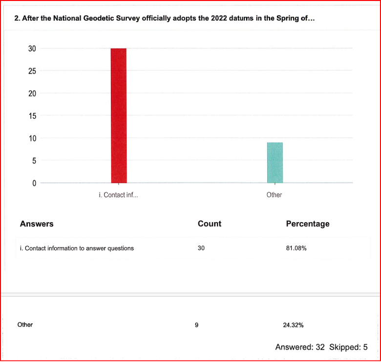
    Researchers at the University of Bonn developed the method several years ago and tested it on the Lower Rhine. With support from the European Space Agency (ESA), the monitoring system is now also being used in Africa and the Asia-Pacific region.

    Researchers at the Institute of Geodesy and Geoinformation at the University of Bonn, led by Makan Karegar, have transferred water -level monitoring technology from the Rhine to Africa, Australia and the Philippines as part of ESA projects. Originally developed in the DFG Collaborative Research Center SFB 1502 (DETECT), the technology enables continuous, freely accessible monitoring of inland and coastal waters in data-poor regions worldwide.

    Active on three continents

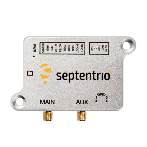
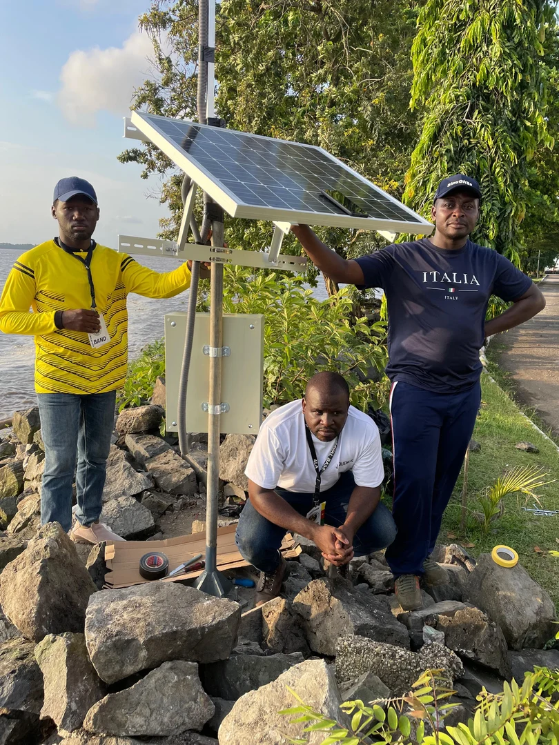
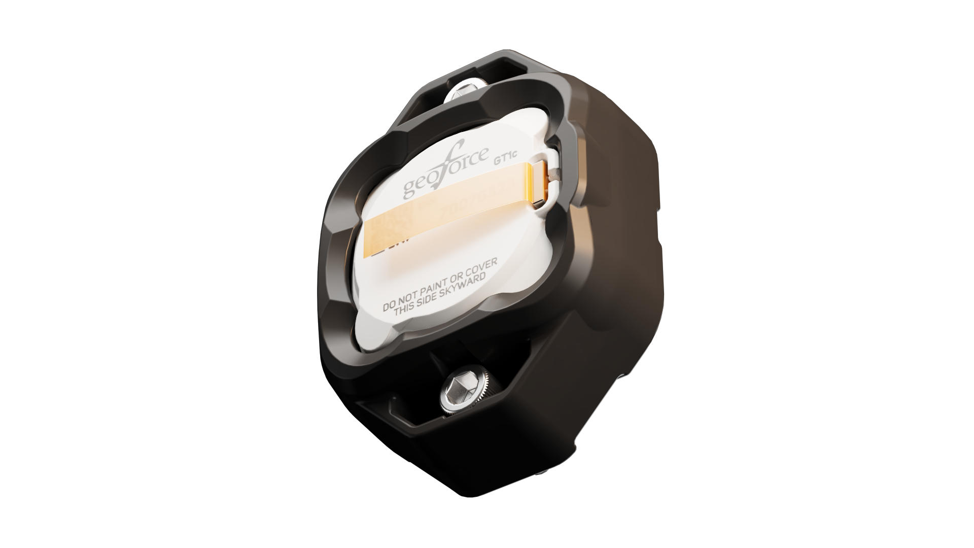
    The technological centerpiece is the Raspberry Pi Reflector (RPR), a compact, solar-powered sensor developed at the University of Bonn. Using GNSS-IR, it measures water levels with centimeter-level accuracy.

    Only a portion of the signals emitted by the GNSS satellites is directly captured by the antenna. The rest is reflected by the water surface and reaches the receiver via this detour. When superimposed with the directly received signal, it forms specific patterns known as interference patterns. These can be used to calculate the distance from the antenna to the water surface.

    Each unit costs less than 800 euros, is powered by solar energy, and transmits data daily via mobile networks. “Modern gauge stations are prohibitively expensive, and conventional ones are highly vulnerable to flood damage,” said Makan Karegar, project manager. “These two factors together have left many countries in the global south with little to no ground-based water-level monitoring. The low-cost GNSS-IR sensor was developed precisely to address this gap.”

    CAMEO-WAGST Project

    The CAMEO-WAGST project (“Cameroon Advanced Measurements for Enhanced Observations of Water levels using Affordable GNSS-IR and Sentinel-3 & 6 Technology”) has established the first dedicated GNSS-IR network for monitoring water levels along coasts and rivers in Camroon and was funded by ESA. Between May and June 2025, researchers collaborated with Loudi Yap, director of the Research Laboratory in Geodesy at the National Institute of Cartography to install eight RPR sensors in Cameroon: two on the Sanaga River and six along the coast. “A lack of infrastructure for reliable hydrological and coastal monitoring in Cameroon has so far hindered effective flood risk management and early warning systems,” Yap said.

    This collaboration, under the umbrella of the EO Africa Research and Development Facility, is already bearing fruit, said Roelof Rietbroek, research coordinator at ESA’s EO Africa R&D Facility. “We hope this paves the way for more reliable monitoring of flood-prone regions in Africa.”

    St3TART-FO Project

    Building on this success, the follow-up project St3TART-FO also was launched in collaboration with ESA. A total of 17 RPR sensors will be installed in seven countries, including West Africa, Australia and the Philippines. “The goal is to create a freely accessible reference measurement network for calibrating satellite data,” Karegar said. For the first time, the network will provide continuous water-level data at previously unmonitored locations.

    The collaboration is based on years of scientific exchange between Africa and Europe. Partners include:

    • International Institute for Water and Environmental Engineering (2iE), Burkina Faso
    • National Institute of Cartography, Cameroon
    • Environmental Protection Authority (EPA), Ghana
    • Nigeria Hydrological Services Agency (NiHSA)
    • University of Maiduguri, Nigeria
    • Assane Seck University of Ziguinchor, Senegal
    • University of Southern Queensland, Australia
    • University of the Philippines Diliman.

    Technology Transfer and Capacity Building

    Both projects promote technology transfer and local capacity building through training, workshops and mentoring, enabling partner institutions to operate RPR networks independently. “We want to leave behind a sustainable monitoring capacity that is operated by local scientists and institutions, openly shared with the world, and maintained well into the future,” Karegar said.

    With financial support from the Transdisciplinary Research Area (TRA) “Sustainable Futures” at the University of Bonn, Karegar developed the open-access data platform gnss4surfacewater.com, which provides an independent, ground-based service for monitoring current and historical water levels using GNSS-IR. Also visit CAMEO-WAGST GitHub for code and field photos.

  • Team Elaris wins £6M eLoran contract

    Team Elaris wins £6M eLoran contract

    QinetiQ-led Team Elaris has been awarded a £6 million contract with the UK Ministry of Defence (MOD) to develop a deployable solution concept for enhanced long-range navigation (eLoran).

    Work completed under the two-year Urgent Compass program will be used to inform future demonstration, production and deployment packages of work.

    The UK and its allies rely heavily on position, navigation and timing (PNT) for effective military operations. PNT solutions traditionally use GNSS signals, but these can be jammed or spoofed by adversaries in battlefield environments. A jammed or spoofed satellite navigation signal, if undetected or uncorrected, can result in misdirected troop movements or incorrectly guided missile trajectories, leading to mission failure in the battlefield arena.

    Militaries are increasingly looking for alternative, more resilient PNT solutions to enhance and complement traditional GNSS, such as eLoran which is a terrestrially based alternative and can operate when access to satellite PNT is denied. This program extends QinetiQ’s engagement with MOD on assured PNT solutions, which includes the Robust Global Navigation System (RGNS) program — another key component in UK MOD’s approach to resilient PNT.

    Urgent Compass will explore eLoran based solutions that can be quickly deployed into contested locations worldwide.

    Team Elaris is made up of QinetiQ, UrsaNav, Roke and GMV. Each organization brings technical knowledge and domain expertise in PNT technologies to the partnership, which is exploring both deployable and fixed eLoran solutions.

  • Geoforce launches GT1c with AT&T Business for rugged asset tracking

    Geoforce launches GT1c with AT&T Business for rugged asset tracking

    Geoforce has launched the GT1c, which enables rugged cellular equipment tracking at scale. According to Geoforce, the GT1c has a more cost-effective, purpose-built design to complement Geoforce’s full range of satellite tracking devices.

    The GT1c operates on AT&T’s network, built for the next era of IoT connectivity for business. The device’s launch builds on a collaboration with AT&T Business announced in March and represents the first product outcome of the relationship.

    The GT1c captures and feeds smart location updates to Geoforce’s mobile-enabled asset intelligence platform, providing field operations and asset managers with visibility into the location, movement and utilization of industrial assets and equipment.

    The GT1c has an encapsulated design, reinforced bezel, and intrinsic safety certification to ensure that it can survive in hazardous, heavy-vibration environments and extreme temperature ranges. It’s low price means customers can afford to track almost every asset class, the company said.

    Pilot program demonstrates value

    In a pilot program with Black Diamond Equipment Rental, the GT1c demonstrated that expanding tracking across mid-tier and small assets is both practical and operationally impactful. The heavy-duty equipment rental company expanded tracked inventory by 26% across smaller and mid-tier construction and oil and gas rental assets. The result was a significant reduction in operational friction and time savings expected to exceed 500 hours per year.

    The GT1c is suitable for

    • oil and gas
    • construction
    • military and defense
    • industrial/manufacturing
    • waste management
    • equipment rental.
  • Update on NC 2022 reference frame working group: Preparing information for NC geospatial providers and users

    Update on NC 2022 reference frame working group: Preparing information for NC geospatial providers and users

    In my October 2025 GPS World Newsletter, I highlighted professional societies forming working groups for the new NSRS — the National Society of Surveyors (NSPS), the American Society of Photogrammetry and Remote Sensing (ASPRS), and the American Association for Geodetic Surveyor (AAGS). Under Gary Thompson’s leadership, the North Carolina Geodetic Survey also established the North Carolina 2022 Reference Frame Working Group (NC RFWG), which includes representatives from NC agencies that produce or use geospatial products and services. This newsletter spotlights several NC RFWG activities to inform and assist other agencies and working groups.

    As noted in my previous newsletter, NC RFWG agencies are proactively conducting self-assessments of their needs and processes to identify challenges and opportunities early, enabling a smooth transition and sustained operational efficiency. The working group meets monthly to review progress on activities.

    One key task of the working group was to develop a short online questionnaire. The goal was to open a dialogue with geospatial professionals and better understand their readiness for the upcoming modernization of the National Spatial Reference System (NSRS).

    The questionnaire was designed to address the following key questions:

    • Are you prepared to implement the new NSRS once the National Geodetic Survey (NGS) officially adopts it?
    • Do you have the necessary tools and resources in place to ensure a smooth transition?
    • Has your organization established a timeline for transitioning to the modernized NSRS?
    • What concerns do you have regarding the transition to the new NSRS?

    The section titled “Introduction of North Carolina Questionnaire” explains the purpose and background of the survey, while the section titled “North Carolina Online Questions” presents the list of questions included in the questionnaire.


    Introduction of the North Carolina Questionnaire

    This questionnaire seeks stakeholder input on the upcoming modernization of the National Spatial Reference System (NSRS). Your feedback is welcome on the proposed questions, as well as any concerns about the datum transition, tools (such as updated NCAT, OPUS, and SPCS2022), data transformation strategies, workflow impacts, and preparation needs.

    The National Geodetic Survey (NGS) is replacing the North American Datum of 1983 and the North American Vertical Datum of 1988 with new plate-fixed terrestrial reference frames (NATRF2022, PATRF2022, CATRF2022, and MATRF2022) tied to the International Terrestrial Reference Frame 2020, along with the new vertical datum, the North American-Pacific Geopotential Datum of 2022.

    In spring 2027, new horizontal and vertical datums will be implemented:

    Horizontal

    • North American Terrestrial Reference Frame (NATRF2022)
    • Replaces the North American Datum of 1983 (2011)

    Vertical

    • North American-Pacific Geopotential Datum of 2022 (NAPGD2022)
    • Replaces North American Vertical Datum of 1988

    Units

    • 14B NCAC 03 .0602 REQUIRED FOOT CONVERSION

    North Carolina Online Questions

    The section titled “Results of North Carolina Online Questionnaire” summarizes the survey responses collected as of April 27, 2026.

    [Note: NCPMA refers to the North Carolina Property Mappers Association, and LGUC refers to the North Carolina Local Government Committee.]


    Results of the North Carolina Online Questionnaire

    (April 27, 2026)


    This questionnaire solicited input from the North Carolina Property Mappers Association (NC PMA), the North Carolina Geographic Information Coordinating Council (GICC), and the North Carolina Local Government Committee (LGC). Although focused on North Carolina, the results may benefit other working groups. The NC working group is reviewing all feedback—especially regarding the Spring 2027 datum change—and will develop materials to address it.

    In addition to the questionnaire, the working group prepared a short guidance document on the new reference frames for local governments and state agencies. It outlines how to prepare for the 2027 datum change and covers:

    • Preliminary steps for transitioning when NGS and North Carolina officially adopt the new datums in 2027.
    • Actions users can take now to ready NSRS‑referenced data for the modernized NSRS and the shift from U.S. Survey Foot/International Foot.
    • Estimated coordinate changes with the 2027 adoption of:
      • North American Terrestrial Reference Frame (NATRF2022)
      • North American-Pacific Geopotential Datum of 2022 (NAPGD2022)
      • New national geoid model (Geoid2022)
      • North Carolina State Plane Coordinate System of 2022 (SPCS2022)
    • Current NC statewide digital orthoimagery acquisition cycle and statewide lidar collection schedule.
    • How the NC CORS and Real-Time Network (RTN) will support the modernized NSRS.
    • Web links to more detailed resources.


    The working group is developing a case study on preparing a FEMA Elevation Certificate using the modernized NSRS (NATRF2022 and NAPGD2022). It will be featured in upcoming newsletters. The North Carolina Geodetic Survey will host the materials on its website, and I’ll share the public link once it’s available.

  • Seen & Heard: Arctic Sea ice, Russian jamming and earthquake monitoring

    Seen & Heard: Arctic Sea ice, Russian jamming and earthquake monitoring

    New insights into Arctic sea ice

    micheldenijs/E+/Getty Images
    Image: micheldenijs/E+/Getty Images

    Research drawing on data from Spire Global’s GNSS-R constellation has enabled the generation of Arctic-wide sea ice maps, marking a major step forward for GNSS-R. The research, enabled by the European Space Agency — suggests harnessing GNSS-R signals could become an important complement to established ice-monitoring altimetry missions. The study leveraged Spire’s GNSS-R data to retrieve sea ice freeboard measurements across an entire winter season. The results show strong alignment with established altimetry datasets, including the ESA’s CryoSat mission.

    Russian jamming goes to the dogs

    Credit: Marit Leinan Abrahamsen/Finnmarksløpet
    Credit: Marit Leinan Abrahamsen/Finnmarksløpet

    Military jamming and spoofing from Russia’s Kola Peninsula interfered with GNSS trackers on dog sleds in Europe’s longest sled race, the 1,200- km Finnmarksløpet, held in Norway in March. The electronic warfare degraded GPS signals, forcing the mushers to rely more on trail markings and use traditional compasses and maps. Event organizers, who provided a live tracking system for fans, found it difficult to follow along, but the racers finished without incident.

    Historical photos find their places

    fstop123/iStock/Getty Images Plus/Getty Images
    Image: fstop123/iStock/Getty Images Plus/Getty Images

    Michigan Technological University is examining 11,000 historical images of the state’s Upper Peninsula to find precisely where each photographer stood to take the photo. According to university GIS data librarian Bob Cowling, the location will provide richer information about a place’s surroundings, especially if structures or environmental landmarks are no longer present. Donated historical images often arrive without any dates or location information attached to them. The project will make them easier to find on a map and make it possible to visualize what was there in the past.

    Türkiye establishes earthquake monitoring

    Credit: mustafaoncul/iStock /Getty Images Plus/Getty Image
    Credit: mustafaoncul/iStock /Getty Images Plus/Getty Image

    In February 2023, a devastating 7.8-magnitude earthquake struck near the Türkiye-Syria border, followed by a second nearly as strong. Six Turkish universities have launched TR-TRAK-GNSS, a real-time geodetic monitoring network to trace earthquake-related ground deformation across Thrace and the Southern Marmara region. The 28-station system is expected to evolve into a major scientific and early warning system for earthquakes. Once fully deployed, it will form a continuous monitoring ring encircling Thrace and Southern Marmara.

  • USSF terminates GPS OCX program

    USSF terminates GPS OCX program

    The GPS Next Generation Operational Control System program of the U.S. Space Force has been cancelled by the Defense Acquisition Executive, based upon the recommendation of the acting service acquisition executive.

    OCX was intended to update command and control of the GPS satellite constellation, replacing the current system, known as the Architecture Evolution Plan (AEP), as well as replacing the Launch, Anomaly and Disposal Operations system. However, the program was unable to deliver needed capabilities on an operationally relevant timeline at an acceptable level of risk to meet the GPS constellation modernization needs.

    “It’s important we refine and update acquisition processes to prioritize rapid, incremental capability delivery versus complex ‘all or nothing’ system deliveries,” said Acting Service Acquisition Executive Tom Ainsworth. “The Department of War [Defense] has made clear that we need to deliver warfighting capability at a faster rate. We must continue to work with industry to meet the needs of our warfighters as we focus on delivering the right technology on the right timeline to enhance our capabilities and maintain space superiority.”

    In July 2025, following a multi-year regimen of factory testing, the Space Force contractually accepted OCX from RTX (Raytheon) and began extensive integrated systems testing to resolve liens carried over from factory testing, as well as to ensure the system could operate within the broader GPS enterprise of ground systems, satellites, and user equipment.

    As of January 2026, the program cost was approximately $6.27 billion which included complete Raytheon funding to date and other government costs, such as the cost of government testing and support costs to the OCX acquisition program office.

    “Regrettably, extensive system issues arose during the integrated testing of OCX with the broader GPS enterprise,” said Mission Delta 31 Commander Col. Stephen Hobbs. “Despite repeated collaborative approaches by the entire government and contractor team, the challenges of onboarding the system in an operationally relevant timeline proved insurmountable. We discovered problems across a broad range of capability areas that would put current GPS military and civilian capabilities at risk.”

    Because of past delays on the OCX program, the Space Force has made incremental improvements over the last 10 years to AEP. These successful upgrades provide confidence that further upgrades to GPS ground systems will continue to support the enterprise and deliver new capabilities.

    “Ultimately, we analyzed the work remaining on OCX and compared this with the current GPS control system capability,” Hobbs said. “The analysis revealed additional investment in OCX was no longer the best solution for protecting and advancing GPS capabilities. Instead, we will continue enhancing the current control system to operate the GPS satellite constellation.”