CyArk, a nonprofit organization focused on digital documentation of cultural heritage, has introduced a new virtual experience of the Mount Rushmore National Memorial in the United States. The 15-minute 3D tour — accessible via web, mobile or tablet — offers users an immersive perspective of the monument, highlighting its engineering achievements, artistic significance and the complex cultural narratives associated with the Black Hills region.
The virtual experience allows visitors to virtually ascend to the summit of Mount Rushmore, offering a close-up view of the faces of former presidents George Washington, Thomas Jefferson, Theodore Roosevelt and Abraham Lincoln. From this vantage point, visitors can better understand the intricsye artistry and scale of the carvings, aspects that are not easily observed during an in-person visit. The tour also includes access to the Hall of Records, a chamber situated behind the memorial, and the Sculptor’s Studio, where a 1/12 scale model of the original design — featuring full busts of the presidents — reveals sculptor Gutzon Borglum’s initial vision for the site.
“Mount Rushmore is one of the most recognized memorials in the world, but its story is far more layered than many people realize,” John Ristevski, CEO of CyArk, said in a news release. “We are proud to share this experience in a way that both highlights the engineering and artistry of the site, and acknowledges the deeper histories of the land on which it stands. Our goal is to bring the complexity of this place to light and make it accessible to new audiences.”
Laser scan of Mount Rushmore (Credit: CyArk)
Culture and Collaboration
A key element of the project is the inclusion of multiple voices that offer diverse perspectives on the memorial. Along with the historical context provided by museum professionals, the experience features commentary, music, and dance from Indigenous cultural interpreters who share their personal reflections on the significance of the land commonly known as the Black Hills.
The virtual tour is based on a highly detailed 3D digital twin of Mount Rushmore, created using advanced documentation methods such as terrestrial lidar scanning and high-resolution photogrammetry. The model incorporates data from the 2010 Scottish Ten project — a collaboration between the Scottish Government, the Glasgow School of Art and CyArk — as well as imagery from a 2016 CyArk expedition. These datasets were combined to reconstruct the memorial with millimeter-level precision, capturing both the prominent sculptures and lesser-known features like the Hall of Records and the Sculptor’s Studio. CyArk collaborated with local partners, historians and Indigenous cultural interpreters to shape the narrative and included archival photos from the memorial’s construction.
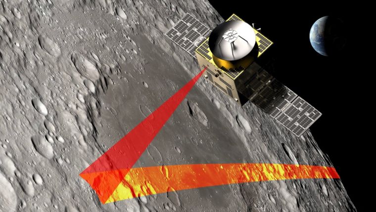
SFL Missions joins a team led by NUVIEW GmbH, which the European Space Agency has contracted to conduct a Pre-Phase A study for the Moonraker lunar mapping mission. This study launches under a new initiative for Small Exploration Missions. The Moonraker satellite will carry a laser scanner to create a detailed elevation map of the Moon’s surface.
The Moonraker mission will deploy a single orbiter in a low-altitude polar orbit around the Moon. The orbiter will host a lidar payload to capture highly accurate elevation points of the terrain. The team will use these data points to generate three-dimensional elevation models, which will guide the assessment and selection of future lunar landing sites.
Moonraker’s lidar data also seeks to advance broader scientific research. The mission will scan permanently shadowed regions to search for water ice and provide new insights into the Moon’s geology and internal composition. The Moonaker lidar will operate in two modes: one for broad-area scanning of the lunar polar regions and another for high-resolution surveys of specific areas of interest.
SFL Missions shared in a statement that Mission analysts are evaluating potential launch options and trajectories to efficiently enter lunar orbit. They are also studying how operational orbit parameters affect spacecraft design and payload data collection. The system design team focuses on accommodating the payload, configuring the spacecraft layout, and sizing subsystem components. They are designing the propulsion system to carry enough fuel for the transit phase and to maintain the operational orbit, compensating for disturbances from the Moon’s irregular gravity field. The team is developing detailed mission and system requirements to guide future design phases.
NUVIEW GmbH, based in Berlin, leads the Pre-Phase A study team, which includes several partners alongside SFL Missions. NUVIEW GmbH, a wholly owned subsidiary of NUVIEW Inc., is developing the world’s first commercial space-based LiDAR constellation for three-dimensional mapping of Earth.
DJI has unveiled the Matrice 400, designed for a range of applications, including emergency response, power line inspections, large-scale mapping, engineering and construction. The UAV offers a maximum flight time of 59 minutes and can carry payloads weighing up to 6 kg. It is equipped with a lidar and millimeter wave radar-based obstacle sensing system, enhancing its ability to navigate complex environments.
The Matrice 400 features an IP55 protection rating, allowing it to operate in harsh conditions and withstand extreme temperatures ranging from minus 20°C to 50°C, according to DJI. The company also states that the drone is capable of taking off from stationary vessels and landing on moving ships, making it suitable for offshore operations such as wind turbine inspections and maritime patrols.
The UAV offers power-line-level obstacle avoidance, which allows it to detect and avoid buildings and mountains while flying at speeds up to 25 m/s. It uses O4 Enterprise Enhanced Video Transmission technology, which supports image transmission up to 40 km. This is achieved through a 10-antenna system on the aircraft and a high-gain phased array antenna on the remote controller. A built-in video transmission relay module allows operators to use one Matrice 400 as a relay drone, providing signal support for another unit.
The drone is designed for automated operations, featuring multiple intelligent functions to improve efficiency. It supports up to seven payloads simultaneously through four external E-Port V2 ports, with options for single or dual downward gimbals and compatibility with a third gimbal connector on the underside. DJI has also incorporated a range of privacy controls to address the data security needs of enterprise users.
Susceptibility to jamming is a significant military vulnerability of the GPS signal. Through a Defense Innovation Unit contract, Leidos is developing an alternative navigation technology that measures variations in the Earth’s magnetic field and harnesses the quantum properties of nitrogen in diamonds.
“With magnetic navigation (MagNav) there’s no signal to jam,” said Aaron Canciani, manager of the Leidos Transition of Quantum Sensing (TQS) team and a former U.S. Air Force scientist who is a pioneer of the technology. “The one thing MagNav does need is a very sensitive magnetometer, which is where quantum comes in.”
Quantum sensing uses microscopic particles that can simultaneously exist in multiple states to more accurately detect aspects of geophysical properties like magnetic fields. Leidos has been doing quantum work for years, applying it to a variety of cyber security and sensing applications.
“Quantum magnetometers have the potential to greatly increase position and attitude accuracies in magnetic navigation systems,” Canciani said. “Nitrogen vacancy-diamond magnetometers use the crystal structure of a diamond to define a sensing axis in which quantum measurements of the complete vector field can be known to exquisite accuracies.”
The sensor is being developed by Frequency Electronics Inc. under subcontract to Leidos and in collaboration with MIT Lincoln Lab.
Compared to classic magnetometers, which tend to drift due to reliance on relative measurements, Canciani added, “These quantum measurements are linked to the magnetic field through fundamental physics-based constants.”
Ultimately, Leidos intends to fly a MagNav system with the new magnetometer. If successful, the technology has the potential to significantly advance navigation technology for military use.
Security company InfiniDome has partnered with one of Israel’s largest vehicle tracking and fleet management companies to simulate a real-world car theft scenario.
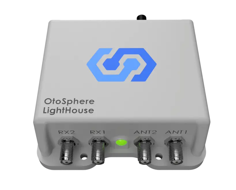
The test recreated a scenario in which criminals deploy in-car GNSS jammers to disable location reporting systems. Two identical tracking units were installed: one protected by OtoSphere-Lighthouse (80×78.5x28mm, 180g), infiniDome’s newest anti-jamming module for commercial use, and one left unprotected.
Credit: InfiniDome
As jamming began inside the vehicle, the unprotected tracker quickly lost GPS signal and failed to transmit location. In contrast, the protected unit maintained full functionality, continuously reporting real-time data throughout the test.
The trial demonstrated the reliability of infiniDome’s technology in commercial environments, the company said. The OtoSphere-LightHouse module was developed to deliver advanced anti-jamming protection for critical applications. As GPS has become essential across industries — from logistics to emergency service — so have the risks.
InfiniDome’s presence at the International Drone Show in Denmark June 18–19, comes at a time when European stakeholders are actively seeking solutions to protect UAVs, maritime, and fleet operations from GNSS disruption — a risk that’s no longer theoretical.
13 member states of the European Union have called on the European Commission to respond to interference with GNSS in EU countries.
The interference originates in Russia and Belarus, as a result of the ongoing war with Ukraine.
The ministers for transport from 13 countries urged immediate and coordinated action in response, reports the Baltic Times. The joint letter was signed by the ministers of Lithuania, Latvia, Estonia, Germany, Slovakia, Finland, Slovenia, the Czech Republic, Italy, the Netherlands, Spain, Denmark and Romania.
In the joint letter, the ministers emphasize that since 2022, two types of interference to GNSS — jamming and spoofing — have been observed in the airspace of the Baltic Sea Region, posing a threat to various modes of transport, particularly civil aviation and maritime navigation.
The General Secretariat of the Council of the EU responded to the joint letter with an outline of potential actions.
Evaluate and coordinate the possibility to suspend the right to Russia and Belarus in the ITU to register the use of radio resources while GNSS interference is in progress. The lack of procedural legislation cannot be an excuse for deliberately contravening the spirit of the ITU Constitution and its general principles, endangering public health and life, without suffering any consequences.
Based on good practice of EU and NATO cooperation on critical undersea infrastructure, enhance civil-military coordination mechanisms among Member States for shared monitoring, data exchange, and possible response to GNSS interference. Explore the benefits of dual use of various equipment and measures to combat the risks caused by GNSS interference.
Intensify RFI monitoring by eligible national organizations and bodies, e. g. national regulator, police and military, and aggregate non-classified information on observed RFI to a publicly available near real-time monitoring and alert service on European level.
Accelerate the deployment of interference resistant GNSS services, especially the antispoofing features that are part of the Galileo program, e. g. authentication and/or encryption of signals exchanged between stations and user equipment.
Reassess the current reliance on GNSS-based navigation and develop resilient Positioning, Navigation and Timing (PST) services by deploying alternative or complementary systems, including ground-based legacy solutions. Simultaneously, upgrade and modernize conventional navigation infrastructures to serve as robust backups.
Promote industry-manufacturer collaboration for mitigation tools and updates. Support operator-level reviews of backup system readiness, ensuring non-GNSS alternatives are usable and practiced. 2 TREE2B 9198/25 EN
Draw the attention of critical infrastructure operators and unmanned system manufacturers to the risks that may arise from interference with GNSS.
Develop action plans for different domains (space, aviation, maritime, telecommunications) to avoid potential duplication of efforts and coordinate short-term and long-term measures at EU and national level.
Continue cooperation with all relevant stakeholders (ITU, ICAO, IMO, EASA, EMSA, IATA, EUROCONTROL). These actions, among others, could contribute to building the overall resilience of the critical infrastructure and strengthening safety and security in Europe.
The letter highlights the urgent need to accelerate the deployment of interference-resistant GNSS services, enhance the overall resilience of critical infrastructure, and strengthen safety and security across Europe.
“The current security environment demands a unified response to hybrid threats posed by hostile regimes, as well as close cooperation to strengthen Europe’s preparedness and resilience,” said Lithuanian Transport and Communications Minister Eugenijus Sabutis.
“Disruptions to GNSS signals have a direct impact on strategic sectors such as transport, energy, and telecommunications. To prevent potential incidents, we must act swiftly and decisively at the European Union level — not individually, but in a coordinated manner,” Sabutis said.
The interference is not random incidents but a systematic, deliberate action by Russia and Belarus, which can be used as a hybrid attack on strategic radio spectrum, essential for modern technology, regional safety and security, particularly in transportation.
Furthermore, the ministers call on the EU to increase diplomatic efforts to address the interference and apply pressure on the responsible parties, including legal action against responsible individuals and entities involved in the deliberate interference with GNSS signals, to enhance European safety and security.
“So far, the attempts by several Member States to address the problem have not brought any more tangible results,” the EU General Secretariats said. “Therefore, it is necessary to increase diplomatic efforts to address the interference and put the pressure on the responsible parties.”
The ministers propose intensifying radio frequency monitoring and enhance civil-military coordination mechanisms among Member States for shared monitoring, data exchange and possible response to GNSS interference. They also advocate for accelerating the deployment of interference-resistant GNSS services, particularly the anti-spoofing features of the Galileo program, and for upgrading and modernizing conventional navigation infrastructure.
Reports of increased interference include:
Lithuania: starting from 556 cases in March 2024 to 890 in October 2024 and 1185 in January 2025
Latvia: 790 cases in October 2024 to 1288 cases in January 2025
Estonia: 1150 cases in October 2024 and 1085 cases in January 2025
Poland: 1908 cases in October 2024 to 2732 cases in January 2025.
Russia’s war with Ukraine continues to affect GNSS signal availability in the Baltic Sea, reports LRT News. Aircraft and ships near the Lithuanian seaport of Klaipėda are losing signals becausse of Russia’s efforts to shield its Kaliningrad exclave from potential airstrikes, said Saulius Skvernelis, speaker of the Lithuanian parliament.
“The Russians are protecting the Kaliningrad region from potential air attacks,” Skvernelis told LRT TV. “This is not specifically intended to disrupt or harm our aircraft flying to Lithuania. It’s just that the protection zone extends beyond the Kaliningrad region’s borders, and the threat, the interference, is affecting our territory as well.”
Skvernelis warned that this problem will persist across the region as long as the Kremlin continues its war in Ukraine.
Thirteen European Union member states have called on the European Commission to respond to interference with GNSS in EU countries. In a joint letter, the countries stressed that GNSS interference cases are not random incidents but systematic and deliberate action by the Russian and Belarusian regimes aimed at destabilizing regional infrastructure, especially in the transport sector, reports LRT.
“We can appeal to all EU countries and any institution, but it won’t help as long as Russia uses this kind of electronic protection for its military sites to defend itself against Ukrainian strikes,” Skvernelis said. “We must force Russia to end the war and then this problem will simply go away.”
Representatives from 18 drone technology companies — including AgEagle Aerial Systems, uAvionix, BRINC, Kelly Hills and Pierce Aerospace — participated in a second high-level, invitation-only policy discussion with the White House, hosted by the Office of Information and Regulatory Affairs (OIRA). This most recent engagement was centered on the proposed FAA Rule Part 108, which will define the regulatory framework for beyond visual line of sight (BVLOS) drone operations across the United States.
The finalization of FAA Rule Part 108 is expected to replace the current piecemeal waiver-based system, providing a more predictable, scalable, and innovation-friendly regulatory environment.
Enactment of Part 108 would remove operational barriers, drive capital investment, and unlock next-generation drone technologies that enhance both commercial and public sector applications, explained AgEagle CEO Bill Irby.
“This follow-up invitation by OIRA reaffirms the strategic importance of expanding BVLOS operations for the domestic drone industry,” Irby said. “Thoughtful and timely rulemaking can accelerate innovation, improve safety and compliance, and strengthen the U.S. position as a global leader in drone technology. Of particular value was the discussion of how streamlined regulation will allow broader deployment of autonomous data solutions and open the door for increased economic activity.”
The engagement was made possible in part through the leadership and coordination of the Association for Uncrewed Vehicle Systems International (AUVSI) and the Commercial Drone Alliance (CDA), who played key roles in facilitating industry participation and ensuring productive dialogue between the private sector and federal stakeholders.
Silicon Sensing Systems Ltd and Kongsberg Discovery AS have joined forces to develop next-generation inertial technology. The companies signed the formal agreement June 2 during EXPO in Osaka, Japan.
The agreement will merge the engineering skills of both companies to speed the evolution of products within each company. Kongsberg will use developments to enhance their next generation of high-performance systems – including attitude and heading reference systems (AHRS) and inertial navigation systems (INS). Silicon Sensing will use these outcomes to benefit its precision micro electro-mechanical systems (MEMS) inertial measurement units (IMUs), gyros and accelerometers.
The companies are aiming to achieve navigation-grade performance from a MEMS-based gyro. Navigation-grade refers to a highly accurate and stable gyroscope used in inertial navigation systems (INS) to precisely measure angular velocity and rotational motion.
Gyro sensors measure changes in rotation angle over time, enabling detection of direction, angle, and vibration. They are used in smartphones, game consoles, car navigation systems, industrial equipment and devices requiring vibration detection, camera shake correction and attitude control.
“The diverse range of applications for this technology is expected to grow significantly in the future,” said Anders Rønningen, executive vice president, Kongsberg Discovery. “This agreement will foster growth for both companies, as well as for Norway, Japan and the UK. We have established a strong presence in the maritime market and are now venturing into new markets.”
“For over a year we have been working with Kongsberg Discovery, exploring how best to bring our engineering teams together to move us towards performance goals that will extend the capabilities of our entire product portfolio – bringing real operational benefits across many industrial sectors. This important agreement details how we will achieve those ambitions,” said Satoru Miyamoto, general manager, Silicon Sensing (Japan).
David Somerville, General Manager at Silicon Sensing (UK), concludes, “This endeavor will fast-track development activities in key areas for both companies, bringing critical performance gains for customers in fields as diverse as satellite control, subsea mapping, industrial robotics, aviation and maritime.”
NOTE: This article is adapted from an April 2025 U.S. National Grid Institute (USNGI) filing with the Federal Communications Commission (FCC) in response to an FCC Notice of Proposed Rulemaking on wireless location accuracy. The USNGI is a non-profit organization providing educational outreach and technical assistance to federal, state, local, and tribal governments, as well as commercial entities, to facilitate use of the USNG for a variety of purposes and, importantly, to support emergency responders in time critical situations (see usngi.org for more information). — Jules McNeff, GPS World Editorial Advisory Board
The term “golden hour” in medicine refers to the concept that rapid response is essential to improve chances of survival following a traumatic incident. Although the actual “golden” duration may vary, it encompasses the time required for incident detection and location, notification to the emergency call center, dispatch of responders, immediate triage and transport to an emergency medical facility. This timeline assumes that the incident location is clearly identified and effectively communicated to the call center and then to responders. Both the call center and the responders must also be educated in the use of geoaddresses. That is not always the case, and we are all familiar with situations where the location of responders was unclear or responders were misdirected, and victims died as a result.
Since its inception, GPS has been described as providing a “common-grid coordinate system” for users. While well-meaning, this is incorrect, as it does not account for real “coordinate system” differences. In fact, GPS employs a common reference frame, which defines the shape of the Earth based on the latest realization of WGS-84 within the International Terrestrial Reference Frame. People may then superimpose different coordinate systems over the global reference frame for the purposes of positioning, navigation, surveying, geodesy and other applications. These diverse coordinate systems are the “languages of location” that can result in confusion and operational friction if their uses are not deconflicted upfront; the consequences of which can prove fatal in emergency response situations, as emphasized here.
A Universal Language of Location
The Federal Communications Commission (FCC) has been working for years to address these deficiencies through improvements to E-911 services, both for wireline and wireless networks. Most recently, in March 2025, the FCC issued its (sixth) Notice of Proposed Rulemaking (NPRM) addressing wireless E911 location accuracy. In it, the FCC focused on requirements for more precisely determining three-dimensional locations, particularly the vertical component in structures. What is missing in this NPRM (and previous versions) is a clear understanding of the means to first identify the horizontal component of the incident location and report it to responders in unambiguous terms.
That missing element is a definition of which “language of location” (reporting format) should be used to identify incident locations to responders. With access to current technologies such as GPS and complementary positioning sources, it is natural to focus on the precision of location technologies. However, it is equally important to address specifically how a defined location is then reported to the responders who must locate it once they are dispatched. Modern technology can deliver precise three-dimensional locations, but the emphasis for responders must first be on understanding the horizontal component. If they do not arrive at the right horizontal geoaddress due to location reporting confusion, then the vertical component, even if it is relevant, does not matter.
The most common reporting format in urban and suburban areas is, of course, the street address. However, even within developed metropolitan areas, street addresses are not always consistent or definitive. In disaster situations, they may not even be present due to wind, flooding, fire or other physical destruction. They are also not useful in rural and remote areas away from established infrastructure. Another common format is latitude and longitude (lat/lon), which the public is aware of but not familiar with in terms of describing a specific location. Additionally, the use of lat/lon is complicated by the fact that it is a spherical system, and a location may be identified in any one of three different lat/lon versions, depending on how degrees, minutes and seconds are combined. Using the wrong version can lead responders far astray, resulting in lives lost. Other formats are available, but many are proprietary, difficult to understand, unfamiliar to the public and/or, most importantly, not directly available from proven position determination technologies such as GPS.
USNGI Presents a Solution
In its filing, the USNGI advocates that the FCC direct wireless communications providers to replace all references to civic (street) addresses and to latitude and longitude in reporting the horizontal component of incident locations with the term “U.S. National Grid (USNG) geoaddress.”It also recommends that the FCC consider rules under consideration that direct wireless providers to display USNG coordinates for horizontal addressing, using z-axis elevations provided by other technologies.
The USNG is a publicly available Federal Standard (FGDC-STD-011-2001) established in 2001 by the Federal Geographic Data Committee (FGDC) as a nationally consistent grid reference system and the preferred grid for National Spatial Data Infrastructure (NSDI) applications. The USNG creates horizontal geoaddresses that are unique, much easier to understand than latitude and longitude and always identifiable because they are referenced to a global grid and not to local features. In a simple format, the size of a telephone number, the USNG can define locations today to an accuracy of 10 m, far exceeding the 50 m requirement in the proposed rulemaking.
As noted above, USNG geoaddresses provide a clear and unambiguous way to describe locations in areas away from established road networks, or those affected by a natural disaster, where road signs have been destroyed. To make their use by the general public and emergency responders even easier, a variety of free smartphone applications are available today that provide continuous USNG geo-locations when activated.
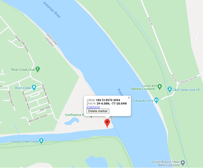
An object lesson is provided by one example (of many throughout the country), the drowning of a teenager named Fitz Thomas on the Virginia side of the Potomac River on June 4, 2020. This tragedy drew much local and even national attention. The teen was swimming at a small creek with friends in a park adjacent to a development, but without a street address. When he got in trouble, his friends tried to help and then called 911 on their cell phones, but could not describe their specific location. Because of the location confusion, coupled with jurisdictional failures, Fitz Thomas could not be saved. If the frightened teens had only been aware of, or had been asked/told by the 911 call center to give the center their geoaddress (which they could have gotten on their cell phones), all uncertainty about the incident location would have vanished immediately, and response could have been dispatched in the instant. The graphic shows the area with a 10 m USNG geoaddress, but which the group was not aware of at the time. The short geoaddress they needed was: TJ 8570 3094.
The location on the Virginia side of the Potomac River where Fitz Thomas tragically drowned on June 4, 2020.
Real-World Applications
USNG geoaddressing has been adopted by many federal agencies and by several state and local governments to facilitate emergency response operations:
The Federal Radionavigation Plan (FRP): The FRP, signed by the Secretaries of Defense, Transportation, and Homeland Security, states in Section 1.7.8 (Interoperable U.S. National Grid for Emergency Response Operations) that “…public availability of location-based applications in mobile electronic devices has highlighted the need to create awareness in the USG and among the public of a standard means to identify accident and other incident locations for emergency response purposes. Lack of a uniform method for describing incident locations has been a major impediment to rapid and effective emergency response in diverse metropolitan and rural areas.” It identifies the objective of the USNG standard “…to increase interoperability of location-based services by establishing a nationally consistent and preferred grid reference system to enable user friendly position referencing on gridded paper and digital maps in combination with GPS receivers and Internet map portals.”
The National Search and Rescue (SAR) Committee (NSARC): The NSARC designated the USNG as a preferred land search & rescue coordinate system in 2011. NSARC manuals specify use of the USNG as the primary georeferencing system for land SAR operations and for air-land SAR coordination. This aligns with coordination of military/civil responder operations as noted below.
The Federal Emergency Management Agency (FEMA): In October 2015, FEMA issued FEMA Directive 092-5, titled “Use of the United States National Grid (USNG),” which states as FEMA policy that, “FEMA will use the United States National Grid (USNG) as its standard geographic reference system for land-based operations and will encourage use of the USNG among whole community partners. FEMA will reference and employ the USNG in doctrine, relevant preparedness and grant programs, deliberate and crisis-action planning, training, exercises, operations, logistics, and other appropriate disciplines.”
Urban Search and Rescue (USAR): FEMA USAR teams adopted the USNG as a response to lessons learned during Hurricane Katrina and subsequently have deployed using the USNG in various disaster response operations. Also, during the aftermath of Hurricane Katrina and others, Delta State University in Mississippi produced a wide variety of map products incorporating the USNG to assist federal and state emergency responders.
In his statement relative to the proposed rulemaking, Chairman Carr noted a visit to Fire Station 40 in Fairfax County, Virginia. That is the home station for Virginia’s FEMA USAR Task Force 1, a world-renowned rescue team and early adopter of the USNG. The firefighters he met with that day may well have mentioned their use of the USNG in describing to him how location technology assists in the execution of their missions.
The DHS National Incident Management System (NIMS): The DHS NIMS identifies the USNG as “… a point and area location reference system that FEMA and other incident management organizations use as an alternative to latitude/longitude. The National Grid is simple to apply to support risk assessment, planning, response, and recovery operations. Individuals, public agencies, voluntary organizations, and commercial enterprises can use the National Grid within and across diverse geographic areas and disciplines. The use of the National Grid promotes consistent situational awareness across all levels of government, disciplines, threats, and hazards, regardless of an individual or program’s role.”
Joint Military/Civil Emergency Response Operations: As noted in the FRP, “The USNG is the civilian version of the Military Grid Reference System (MGRS) that the military uses for tactical operations. It enables geolocating incident locations from 100m to 1m precision.” A Chairman of the Joint Chiefs of Staff Instruction (CJCSI 3900.01E) on georeferencing states that, “To support homeland security and homeland defense, the USNG standard is operationally equivalent to MGRS.” As with the MGRS, the USNG is easy to learn by all levels of personnel, it is interoperable if used by civil and military first responders, it improves military support to civil authorities, and very importantly, it reduces operational friction and facilitates crisis and disaster response at all levels from federal to local government.
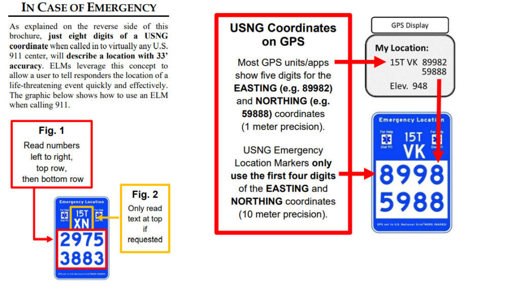
Emergency Location Markers (ELM): Localities in Minnesota, Georgia, Florida and other communities across the U.S., including National Parks, and even the Kennedy Space Center, have installed USNG-based ELM to give trail and park users a way to report an emergency location. Due to the disparate physical locations involved, nearly all such incident reporting can be expected to come from wireless systems, but to be enabled by reception of GPS positioning signals. The graphics below show the ELM relationship to GPS and how the reporting is facilitated by use of the USNG.
The ELM relationship to GPS and how the reporting is facilitated by use of the USNG.
What urgent policy or industry actions are needed to protect and advance resilient PNT services amid spectrum sharing debates and GNSS regulation changes?
Jules McNeff, vice president, strategy & programs, Overlook Systems Technologies
In my article, “Is There a Silver Bullet for Resilient PNT?”, I addressed the confusion caused by the numerous and diverse industry initiatives now being offered. Industry is understandably motivated to provide resilient PNT capabilities, but each also wants the government to pick its solution and make policy decisions accordingly. Spectrum sharing decisions that favor a single service provider may harm others in a crowded space, and so are difficult or impractical, as we have seen with the decades of litigation associated with LightSquared/Ligado and the spectrum surrounding the GPS L1 frequency.
Not everyone can win that competition, and as I noted at the end of the article, “Unless our government accepts responsibility, there will be no PNT silver bullet for domestic CI. Experience shows that industry will not solve this problem alone.”
For years, I have advocated that U.S. PNT technology policy be managed and services acquired holistically as vital dual-use civil/military capabilities. For the civilian community, that means making sure the national leadership understands the reliance our domestic critical infrastructure (CI) has on constant access to precise PNT to maintain continuity of operations across all CI sectors in the face of well-known threats. The leadership must then decide whether that reliance deserves proactive attention by the government to ensure PNT continuity is not disrupted.
Several years ago, I suggested that significant regulatory changes were needed in how civil PNT services were handled throughout U.S. CI. Both the Departments of Homeland Security and Transportation were assigned responsibility in Presidential Directives for finding a GPS backup to PNT services in domestic CI. I won’t revisit that years-long debate (which is still unsolved), but I will revive the framework of the suggestion.
The DOT has overall responsibility for civil agency PNT matters, and DHS frequently cites lack of regulatory authority as a limitation on its ability to encourage compliance in the CI sectors for which it is responsible. Therefore, I suggested that the National Space-Based PNT Executive Committee consider regulatory changes to expand the definition of the Transportation CI Sector to include safe and uninterrupted transportation of all elements contributing to domestic critical infrastructure. In addition to current air, road, rail, and oil/gas pipeline transportation, add the interstate transport of information (Communications and IT), electrical energy (Power Grids), economic transactions (Finance), crops (Agriculture), and water, as well as domestic maritime services (U.S. Coast Guard) and possibly emergency response services in the case of large disasters.
In the spirit of the former Interstate Commerce Commission, which years ago was replaced by a DOT Surface Transportation Board (primarily concerned with freight rail), the DOT may then seek expansions to STB authorities and membership to address the PNT dependencies and vulnerabilities affecting those fundamentally transportation-oriented activities vital to the viability of all U.S. critical infrastructure sectors.
— Jules McNeff Overlook Systems Technologies
Miguel Amor, chief marketing officer, Hexagon’s Autonomy & Positioning Division
Regulatory authorities must quickly approve and protect RF spectrum allocated for new PNT capabilities, particularly for emerging low-Earth orbit (LEO) constellations. These systems offer clear advantages in signal strength, geometric diversity and resilience against jamming and spoofing. Without timely and well-defined spectrum authorization, along with strong adjacent-band protections, the deployment of GNSS receivers capable of supporting these constellations will be delayed.
On the industry side, LEO PNT developers must urgently finalize signal structures and release Interface Control Documents, enabling GNSS receiver manufacturers to begin implementation, validation and system integration.
— Miguel Amor Hexagon Positioning Intelligence
Mitch Narins, Strategic Synergies
Interesting and timely question. I’ve written quite a few pieces and papers on the need for resilient and robust PNT services. If I were to point to a single thing that has held the US (and many other countries in the world back (except for China) it is lack of strong mission-oriented, dedicated leadership. It has been said that the definition of a committee is an entity with four or more legs and no brain. It is time to designate a single entity and a single office and a single person as responsible for ensuring resilient PNT services to US critical infrastructure so as to maintain the safety and security and economic benefits these these sectors support. Some wise men once came up with the idea that a government must “provide for the common defense” and “support the general welfare.” Resilient PNT is essential to achieving both.
In addition to the lack of empowered, centralized PNT leadership, a key problem that has impeded progress towards resilient PNT is the lingering belief by many that given enough time and money and spectrum, GNSS-sole means is achievable and that all non-GNSS systems (affectionately called “Legacy PNT Systems”) can be discontinued. In fact, over the years budget justifications for GNSS systems have used discontinuance of ground-based systems as “a benefit” to balance out the costs of establishing, updating, and operating GNSS.
Engineering System Designer should never fall in love with their solutions. The mission, i.e., the needs of the customers must always remain their first concern. After many years, integrity was added to the list of PNT metrics; coverage has yet to be officially added. Yet, even today, there remains confusion regarding the availability metric and the associated risks. For GNSS systems, the risk of losing required PNT metrics should always be considered “1.0”, and therefore, for critical infrastructure users and providers, require effective and implementable contingency/continuity of operation plans. Loss of PNT performance (accuracy, availability, integrity, continuity, and coverage) the using GNSS can no longer be considered a “Black Swan” event.
— Mitch Narins Strategic Synergies
In the February 2025, Professor Washington Ochieng proposed the following question to the GPS World EAB.
When we discuss the security of GNSS/PNT systems, we nearly always focus on interference — i.e., meaconing, intrusion, jamming or spoofing. However, GNSS/PNT systems are embedded in systems of systems that also offer many other opportunities for cyberattacks. What should we do about it?
I have thought for some time about why this is an issue. This is an interesting question, and the answer should be straightforward – but it’s not. For whatever reason, it seems many in the “cyber community” believe they are different, somehow, and apart. This has been apparent to me in dealing with those in the cyber community regarding their PNT dependencies and vulnerabilities going back to the creation of USCYBERCOM as a separate combatant command within the DoD. Those in the cyber world seemingly do not see a need to recognize and account for the intersection of PNT and cyber as mutually integral parts of a broader Information Technology ecosystem. Yet, across that entire IT ecosystem, PNT is simultaneously an enabler and a product of IT functionality, as communications and data systems could not operate without it, and it is likewise vital to IT users in executing their diverse missions. Ultimately, interference effects, whether from jamming or spoofing in their various forms or from digital intrusions of one kind or another, disrupt vital elements of that IT ecosystem. Our national and economic security depend on the continuous, reliable, uncorrupted functioning of IT services enabled by and delivering PNT information. So, a straightforward but difficult to implement answer is that we need formal education programs to routinely inform the leaders of industry and government (and the public) of the ubiquitous, vital role of positioning and timing (what we call PNT) throughout all the systems-of-systems whose operation depends on the IT ecosystem – and how to tell if something is amiss.
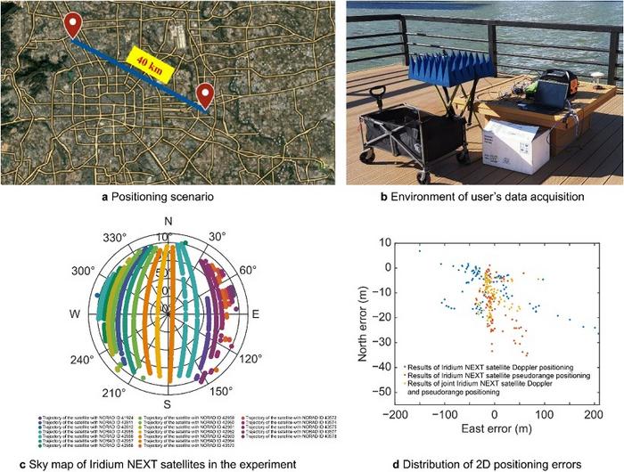
A novel method using signals of opportunity from low-Earth orbit (LEO) satellites is redefining what’s possible in satellite-based navigation. Researchers have developed a joint pseudo-range and Doppler positioning technique that taps into signals from constellations like Starlink and Iridium NEXT — without relying on traditional navigation signal structures.
By employing low-cost, wide-beam antennas and a specially designed time–frequency inversion algorithm, the team achieved remarkable accuracy: 3.6 meters in 2D and 6.2 meters in 3D, surpassing Starlink positioning approaches based on parabolic antennas by 35%.
Technical barriers in using signals of opportunity include signal transmission times, low signal power, and imprecise orbital data, all of which hinder accurate positioning. Addressing these challenges demands a new approach to extracting usable navigation data from LEO constellations.
In response, researchers from the Aerospace Information Research Institute introduced a joint pseudo-range and Doppler positioning method using wide-beam antennas to receive LEO satellite SOPs. The approach centers on a signal time–frequency inversion algorithm that reconstructs key signal parameters, alongside a novel accuracy metric called Equivalent Position Dilution of Precision (EPDOP).
Real-world experiments combining Starlink Doppler data and Iridium NEXT pseudo-range signals confirmed strong performance, especially in long-baseline conditions — reinforcing the method’s global applicability.
To overcome the cost and complexity of existing satellite tracking equipment, the team employed low-noise bock (LNB) wide-beam antennas capable of simultaneously receiving signals from multiple Starlink satellites. The core innovation lies in a signal processing algorithm that estimates transmission time and frequency from the received code phase and Doppler shifts — enabling both pseudo-range and Doppler observations without needing exact satellite clock data or real-time ephemeris.
To quantify system performance under real-world errors, the researchers developed the EPDOP metric, adapted to mixed measurement inputs. Tests demonstrated the method’s robustness: 3.6 m 2D and 6.2 m 3D positioning using Starlink Doppler signals, and up to 24 m (2D) and 41 m (3D) accuracy using Iridium NEXT SOPs over a 40 km baseline. Compared to Doppler positioning techniques, the algorithm reduced positioning errors by over one-third and successfully suppressed the impact of orbital inaccuracies inherent in public two-line element set (TLE) datasets.
“This work marks a key step toward accessible, accurate navigation using commercial satellite constellations,” said lead author Ying Xu. “By integrating Doppler and pseudo-range measurements and introducing a flexible precision metric, we can now harness Starlink and Iridium NEXT signals for high-precision positioning, even without access to proprietary signal structures. The proposed low-cost architecture opens new possibilities for resilient navigation in GPS-denied environments.”
Because of its ability to operate with low-cost antennas and weak, unstructured signals, the technique is poised to support a wide range of applications: from autonomous driving and unmanned aerial vehicle (UAV) navigation in remote regions to emergency response and IoT asset tracking. Its resilience to satellite orbital prediction errors and adaptability across different LEO constellations make it a strong contender for next-generation positioning systems. As LEO deployments continue to expand globally, this approach offers a scalable and practical solution for real-time, high-accuracy navigation—promising enhanced capabilities for both civilian infrastructure and defense operations.