The Federal Aviation Administration (FAA) has partnered with the Naval Air Warfare Center Aircraft Division (NAWCAD) to initiate steps toward approving Controlled Reception Pattern Antennas (CPRAs) for use in aircraft. This collaboration addresses GPS/GNSS jamming and spoofing threats, with the current focus on a Request for Information (RFI) to study anti-jamming and anti-spoofing technologies. The RFI, published on SAM.gov, aims to identify and evaluate vendors’ antenna technologies for potential integration into civilian aircraft.
CPRAs could significantly mitigate terrestrial-based GPS/GNSS jamming and spoofing, enhancing aviation safety by preserving situational awareness and reducing pilot workload during disruptions. The technology’s effectiveness in neutralizing ground-based threats positions it as a critical tool for maintaining reliable navigation systems.
RFI details and next steps
NAWCAD is leading the RFI process, which includes hosting industry days and establishing Cooperative Research and Development Agreements for testing hardware and evaluating performance. Responses to the RFI are due by May 26, 2025, at 5:00 PM EST, with questions accepted until April 25, 2025. Data from the RFI and subsequent testing will inform updated Minimum Operational Performance Standards for GPS/GNSS antennas and cockpit displays.
Dana Goward, president of the Resilient Navigation and Timing Foundation, noted that this is a great first step, but cautioned that widespread adoption of CPRAs in commercial aircraft will take a long time due to the lengthy FAA approval and certification processes, along with the significant financial investment and effort required to install CRPAs in airplanes.
Although CPRAs address terrestrial threats, space jamming continues to be a critical concern. Adversaries often outpace countermeasures, necessitating continuous innovation to keep up with advancing threats.
FAA safety alert highlights risks
The FAA issued Safety Alert for Operations (SAFO) 24002 on Jan. 1, 2024, to alert operators and manufacturers about the risks of GPS/GNSS disruptions. The alert emphasized the potential for increased pilot workload and safety risks due to situational awareness loss during jamming or spoofing incidents.
On Jan. 17, 2025, the State Department proposed removing CPRAs from the U.S. Munitions List (USML), shifting their regulation to the Commerce Department’s Export Administration Regulations (EAR). This change, effective Sept. 15, 2025, aligns CRPA export controls with other dual-use technologies, streamlining their adoption. A 60-day public comment period is open via regulations.gov.
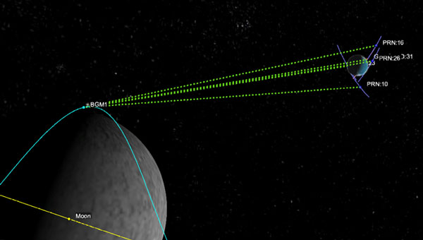
The LuGRE receiver acquired and tracked GPS and Galileo satellite signals in lunar orbit on Feb. 19, operating at 63 Earth radii (approximately 401,814 km from Earth). Developed by Qascom for the Italian Space Agency in collaboration with NASA and supported by Politecnico di Torino, the receiver is integrated into Firefly Aerospace’s Blue Ghost 1 lander as part of NASA’s Commercial Lunar Payload Services program.
During the lander’s lunar transit, LuGRE tracked signals in the L1/E1 and L5/E5 frequency bands. The farthest signal detected came from the Galileo constellation at 67.79 Earth radii (approximately 432,384 km from the receiver). The experiment demonstrated GNSS functionality near the Moon, where the lander orbited approximately 1.66 km/s1.
Despite the challenges of distance and velocity, the receiver achieved position accuracy within 1.5 km and velocity accuracy within 2 m/s. It successfully acquired signals from four GPS satellites (L1 and L5 frequencies) and one Galileo satellite (E1-E5 bands) during a one-hour observation window. Post-landing, LuGRE will attempt to receive GNSS signals on the lunar surface for 14 days.
Eos Positioning Systems has launched a redesigned Eos Tools Pro app on iOS. The updated app features a modern user interface and user experience to enhance usability, functionality and efficiency for professionals using Eos GNSS technology.
The redesigned app includes a reorganized settings menu to improve the organization of all configuration options, offering a centralized space for users to manage their GNSS preferences and optimize workflows. The new interface has been revamped to take advantage of Split View mode on iPadOS to view all pertinent information when using Eos Tools Pro in conjunction with a data-collection app. This is particullarly useful for Skadi Tilt Compensation and Skadi Smart Handle users.
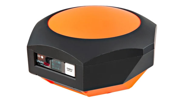
SparkFun Electronics has released the SparkPNT RTK Facet mosaic L-Band, a high-precision geolocation and surveying receiver. It features Septentrio’s multi-band mosaic-X5 and offers centimeter-grade measurements with 6 mm RTK fixes available in less than one minute, according to Sparkfun.
The receiver can connect to phones or tablets via Bluetooth, allowing NMEA output compatibility with most geographic information system software. It uses u-blox’s PointPerfect service for corrections, broadcast from a geosynchronous Inmarsat satellite.
The RTK Facet mosaic L-Band features an ESP32 WROOM connected to a mosaic-X5 GNSS multi-band receiver, along with peripheral hardware. It includes a surveyor-grade L1/L2/L5-Band antenna designed to receive GNSS signals and PointPerfect correction.
The device operates in various modes, including GNSS positioning, GNSS positioning with RTK L-Band, GNSS positioning with RTK, GNSS base station and GNSS base station NTRIP server. In rover mode, it can achieve 6 mm to 60 mm horizontal positional accuracy.
As an open-source hardware product, users can access and modify the electrical and mechanical design files. The kit includes the enclosed device, thread adapter, charger, data cables and carrying case.
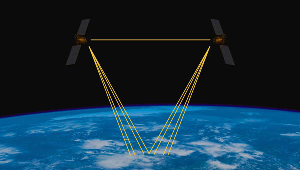
The European Space Agency (ESA) has signed a contract with a consortium of European companies to conduct a definition study (Phase A/B1) and associated critical technology predevelopment to drive the development of optical positioning, navigation and timing (PNT) technology.
This initiative marks the initial phase toward a potential in-orbit demonstrator for optical time synchronization and ranging, which is scheduled for proposal at the ESA Council at the Ministerial Level in November. According to ESA, the primary objective is to validate inter-satellite optical links for future implementation in operational satellite navigation systems.
Optical technology presents promising advancements in navigation accuracy and robustness. While optical links, which use laser beams for data transmission, are already established in satellite communications, their application in navigation requires further technological development and in-orbit validation.
The consortium, led by German OHB System, comprises 33 companies from various ESA member states. Following the initial study, the next phase would involve developing and testing the technology in orbit to validate novel system concepts and explore new architectures. The results will assess the readiness of optical technology and inform decision-makers about its potential incorporation into future operational systems.
Laser-based technology offers the potential for enhanced system resilience and robustness, potentially reducing dependence on space atomic clocks and ground segments. Optical links also provide natural immunity to jamming and spoofing attempts.
The high data transfer rates of inter-satellite optical links could enable new, more robust architectures, supporting a multi-layer system approach to navigation. This aligns with the vision of ESA’s low-Earth orbit (LEO)-PNT program.
Additionally, optical systems can significantly improve the performance of current navigation systems. Experts anticipate achieving millimeter-level spatial accuracy and picosecond-level timing, which could ultimately lead to enhanced services benefiting billions of users worldwide.
It cannot be denied that people are seeing more objects flying in the night sky. It is suspected that these are unauthorized UAVs collecting information over U.S. and international military bases and, well, also over people looking up at the sky in their backyards at night. It is unlikely that these unidentified flying objects are causing much harm to the civilian population other than being a curiosity. However, it remains unclear what they might be doing over military installations.
In November and December 2024, numerous reports emerged of UAVs surveilling residential neighborhoods, restricted zones and critical infrastructure across the Northeast United States. This includes areas such as water storage facilities, transmission lines, railway installations, police departments — both local and federal — and military bases.
Military bases reporting UAV overflights included Wright-Patterson Air Force Base in Ohio, Picatinny Arsenal and Naval Weapons Station in New Jersey and Ramstein Air Base in Germany. In the UK, Royal Air Force (RAF) bases at Lakenheath, Mildenhall, Feltwell and Fairford in the South of England all reported unauthorized UAV overflight activity, which is somewhat concerning for nuclear weapons bases in Europe. Lakenheath appears to have scrambled F-15s to investigate one such UAV incursion.
Detecting and mitigating threats
In the United States, the increased intensity of UAV sightings has residents and Congress concerned, while various authorities claim that most of these incidents are harmless. A joint statement by the Department of Homeland Security, the Federal Bureau of Investigation, the Federal Aviation Authority (FAA) and the Department of Defense stated:
“Having closely examined the technical data and tips from concerned citizens, we assess that the sightings to date include a combination of lawful commercial drones, hobbyist drones, and law enforcement drones, as well as manned fixed-wing aircraft, helicopters, and stars mistakenly reported as drones. We have not identified anything anomalous and do not assess the activity to date to present a national security or public safety risk over the civilian airspace in New Jersey or other states in the Northeast.”
Nevertheless, these agencies reported, “Local commanders are actively engaged to ensure there are appropriate detection and mitigation measures in place.”
No other major announcements have followed these incidents, but it would seem logical that military bases have begun activating existing detection and defensive systems. Known countermeasures may include specialized radar, laser, optical, acoustic and radio frequency (RF) detection and defensive systems.
Radar always has been employed to detect airborne intruders, and the reflections from them appear on a display, which the ground user can then align with a range of potential defenses. However, UAVs are generally small, while conventional radar is designed to pick up hefty reflections from the surface of full-size commercial and military aircraft.
Photo: Robin Radar Systems
Robin Radar Systems
Robin Radar Systems in Holland has worked to refine radar that can detect small flying objects. Birds can cause havoc at airfields where aircraft take off and land at high rates, so detecting birds for airfield operators is one angle for which Robin Radar Systems has developed a reflection capability. A large bird and a UAV might be very similar in size. To differentiate the two, the company found a way to see a Doppler effect (speed differences) within a radar return, which indicates the spinning rotors of a UAV rather than flapping wings — a system they term micro-Doppler radar. This detection system works to find objects many miles away and at well-defined approach angles from the radar antenna. Therefore, these X-Band radars are mostly based at the places you want to protect, such as airfields. Some radars also can be packaged to be transportable, perhaps for military applications, where a temporary base needs to know if enemy attack UAVs might be on their way.
Other principal detection systems include “sniffing” RF frequencies to detect UAV control signals, but this has a shorter range than radar and does not easily determine distance or approach angle without several triangulating bases. Additionally, of course, UAVs without control signals cannot be detected with this particular RF technology. Optical systems using still/video/infrared (IR) cameras are good in daylight, but not so good in the dark. Acoustic systems use microphones or an array of microphones to listen for rotor sounds but have a shorter range (less than 1/3 of a mile).
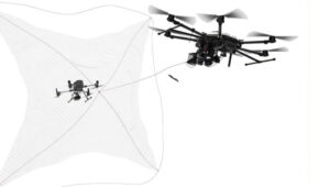
Then, if you have suitable defensive capabilities, you could either take down an unwanted UAV by flying a counter-UAV to collide with and destroy it or by trapping it in a net. In a military situation, many UAVs have been shot down by various types and calibers of guns — and even by very expensive missiles. Electronic defenses include jamming guidance and/or control signals by transmitting signals that overcome and scramble the GNSS and/or control signal or by frying its electronics using high-power microwave transmissions or high-powered laser(s) — these last two systems are expensive and heavy, which makes them cumbersome.
Spoofing the on-board GNSS receiver by transmitting false satellite signals to steer the UAV away from its target recently has been used by Ukrainian forces to steer attack UAVs back into neighboring countries.
GNSS jamming is widely used, and there are numerous equipment suppliers; however, spoofing systems are less common due to their additional complexity and cost. Some RF systems can collect data from the opposing UAV and even detect where the operator might be located.
Of course, not all UAVs straying into restricted airspace come from operators with bad intentions — some might be “Sunday-driver” recreational UAV flyers who have allowed their UAVs to stray into the wrong area. This is another reason the FAA requires formal UAV operator training and certification for commercial operations, but this is not required for recreational UAV flyers.
DroneHunter drone net capture system. (Photo: Fortem Technologies)
FAA regulations
The FAA regulations for UAVs are fairly easy to understand, and it would probably take an intentional effort to fly unauthorized into restricted airspace. Otherwise, stay at or below 400 ft, don’t exceed 100 mph, don’t go where you shouldn’t, file a flight plan — ask permission using the automated FAA LAANC online tool — but always stay within visual range of the UAV. Those are most of the basics. Additionally, to operate a UAV commercially, you must also register it with the FAA and install an electronic device to tell everyone in the surrounding airspace the drone’s registration number, which is traceable to the owner/operator. Never fly near clouds, comply with local rules when flying recreationally, and never, ever fly into restricted airspace, particularly around airports, without prior authorization.
These multiple reported UAV incursions violate FAA regulations, so it is reasonable to assume the operators are deliberately flying illegally. Recreational flying requires the operator to see the UAV at all times — so flying at night is not legal either, as the rules state not to fly an hour after sunset or an hour before sunrise. Operators in restricted airspace are committing a crime punishable by fines and/or years in prison. Yet they still fly, so are they nuisance operators who don’t care or is the activity criminally motivated or orchestrated offshore?
Utilizing UTM
Would the coming unmanned aircraft system traffic management (UTM) have been able to keep these intruders away? I am not sure, but UTM is designed to manage UAV traffic, so presumably, it could manage these UAVs to comply with traffic requirements. However, these intruders are already ignoring existing laws, so UTM may more readily enable the identification of rogue UAVs and operators. Recent tests at the FAA/NASA UTM test range in North Texas have drawn huge interest from Walmart and Amazon, as they push to get UAV package delivery working. Wing now delivers for Walmart using a production UTM system in Dallas and Fort Worth, Texas.
To wrap this up, amongst many recently reported unidentified flying objects, several have been identified as probable UAVs, and some of those over restricted areas could be detected and managed with existing technologies. FAA regulations ban flights in restricted airspace unless approved — i.e., working in coordination with those ground facilities. There are UTMs for UAVs already being used commercially, which could assist in managing all UAVs.
Machine control systems, which combine positioning sensors — both GNSS receivers and inertial systems — with computer displays, give operators better insight into and control over their work. Whether moving dirt on a construction site, spraying crops on a large farm, or moving cargo containers in a port, machine control increases efficiency and precision while decreasing accidents and fuel consumption.
Machine control systems enable operators to accurately position buckets, blades and other implements on their machines without having to first survey and stake the work site, or having to constantly check their work. They give operators a clear reference between the position of the machine bucket or blade and the design surface, thereby increasing their productivity and accuracy. They also utilize labor and equipment efficiently to reduce costs and minimize wear-and-tear. Finally, by collecting data during their operations, they help teams communicate better and share models.
Machine control, which first began to be implemented in the 1990s, is being increasingly adopted across a variety of different types of construction equipment — including graders, dozers, and, more recently, excavators. Now, beyond simply providing operators with a visual guide to the position of their buckets or blades, automated machine control moves the blade to grade by talking directly to the machine’s hydraulics, enabling new or less-skilled operators to perform like long-time professionals and increasing the speed and precision of even the most experienced operators.
The three case studies in this cover story highlight the need for precision control of the implements on earth-moving machines, the importance of good data and the need to make the process as easy as possible for the operator.
The Maldives consists of numerous coral reef islands with low soil-bearing capacity. Using heavy machinery in such an environment requires careful management of movement and precise operations while avoiding damage to local coral reef ecosystems, thus preserving marine life and the natural landscape of the islands.
using heavy machinery among sensitive coral reefs requires careful movement and precise operations to avoid damaging them. Photo: ComNav
As an advanced construction solution, ComNav Technology’s XE100 Guidance System for Excavator employs high-precision GNSS positioning and heading technology coupled with inertial sensors. In construction projects in the Maldives, the XE100 not only provides precise guidance for operators on land but also enables efficient and precise underwater operations in complex marine environments while minimizing ecological impact. Its excellent performance has brought significant benefits to construction projects in the Maldives.
The Maldives’ construction environment is complex and variable, requiring precise equipment to adapt to diverse terrain. The XE100 supports multi-constellation multi-frequency GNSS, delivering centimeter-level accuracy. This ensures that, whether for leveling, slope cutting, or digging, the system delivers precise instructions for bucket operations and guarantees accurate excavator positioning, even in challenging conditions.
ComNav technology’s Xe100 GNSS machine control system delivers centimeter-level accuracy in complex and variable environments. Photo: ComNav
For scenarios requiring underwater operations or mixed land and water tasks, the XE100 overcomes the traditional challenge of locating exact coordinates. The GNSS tablet’s intuitive display of coordinate points helps operators identify work areas and select appropriate excavation actions. This ensures safety, reduces technical barriers, minimizes the need for rework, and significantly enhances construction quality while maintaining high efficiency and precision.
Construction projects in the Maldives often face challenges such as high humidity, high salinity and frequent vibrations. Each component of the XE100 is designed to withstand harsh environments with excellent durability. The system’s modular design also supports expansion to other construction machinery, enhancing flexibility and paving the way for future technological upgrades.
As a nation abundant in marine resources and dependent on tourism, ongoing infrastructure development and maintenance are critical to the Maldives’ economy. The XE100 system improves construction accuracy, reduces operation time, ensures safety, and lowers costs, thereby accelerating project timelines.
Machine control and automation for snow management
The allure of pristine slopes and perfectly crafted terrain parks has always drawn adventurers to the mountains, but the landscape of snow management is shifting dramatically. With rising temperatures and unpredictable weather patterns, climate change poses a significant challenge to the snow sports industry. Natural snowfall is becoming less reliable, leaving resorts dependent on costly snowmaking systems that strain resources and budgets.
Leica Alpine Office enables resorts to achieve operational goals while safeguarding the environment by precisely managing snow management and reducing waste. Photo: Leica Geosystems
For snowparks, these challenges are even more acute. Crafting intricate features such as halfpipes, jumps and rails requires precision and significant amounts of snow — an increasingly scarce resource. Amid these difficulties, the need for sustainability has never been more pressing.
The tech that’s changing the game
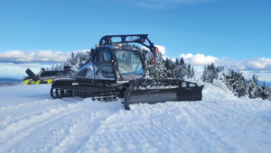
Leica Geosystems’ snow management solution, the Leica iCON alpine, paired with Prinoth snow groomers, is helping resorts get more out of less, making the construction of snowparks more efficient and sustainable.
The Leica iCON alpine system leverages GNSS and advanced inclination sensors and inertial measurement units (IMUs) to measure and manage snow depth accurately. Mounted on any snow groomer, this system continuously collects data, ensuring that operators can see the exact snow depth beneath the blade and tracks — accurate to within ±3 cm. In other words, it’s like X-ray vision for your snowcat.
The Leica Icon Alpine, paired with Prinoth snow groomers, is helping to make the construction of snowparks more efficient and sustainable. Photo: Leica Geosystems
Need a perfect jump? Create a 3D model and import the data, which can be read on the screen inside the groomer’s cab. It even handles tricky terrain with features like avoidance zones and anchor point searches. This setup doesn’t just make slopes look good; it helps operators work smarter, not harder.
Snow measurement for World Cup Slalom course
For the past two years, Killington Mountain Resort in Vermont has been utilizing the Prinoth Connect Snow Measurement system powered by the Leica MC1 software.
Killington is one of the first resorts in North America to invest in snow measurement, and it has been vital to executing the Women’s Slalom and Giant Slalom World Cup builds in 2023 and 2024. Killington has the snowmaking capability to cover the race trail, Superstar, with snow in about 100 hours. With the software, the teams can read the snow depth to +/- 3 cm, using snow measurement sensors instead of long metal probes. The software helps increase the efficiency of both snowmaking and grooming, making the build easier for the grooming operators, more straightforward for officials, and safer for the racers.
Leica’s machine control solution has been vital to precisely executing the Women’s Slalom and Giant Slalom World Cup builds. Photo: Leica Geosystems
From the snow to the dirt
However, Leica Geosystems machine control technology is a year-round solution thanks to its versatile Leica MC1 platform, which allows the same hardware used for snow grooming to seamlessly transition into off-season applications such as summer earthworks, trail construction and road maintenance. With a single investment, resorts get a multipurpose tool that eliminates the need for separate systems, cutting costs and complexity.
For instance, in the summer months at the Rieberalp in Davos Rinerhorn, the Leica MC1 solution powers excavation work for projects such as creating a reservoir and ensuring precise and efficient earthmoving. In the winter, the same system transitions to snow groomers, optimizing snow management on the slopes. This effortless switch between applications highlights the adaptability and value of the Leica MC1 platform, enabling ski resorts to get the maximum out of their investment while maintaining top performance year-round.
Technology for more sustainable snowparks
With precision snow management and reduced waste, resorts can achieve operational goals while safeguarding the environment. Adopting digital solutions such as these ensures that ski resorts and snowparks can continue to deliver world-class experiences for generations to come.
Te Ara Tupua is an initiative by the New Zealand Transport Agency aimed at enhancing transport resilience while establishing a walking and cycling route between Wellington and Lower Hutt. The Te Ara Tupua Alliance includes the NZ Transport Agency and its design and construction partners: Downer NZ, HEB Construction and Tonkin + Taylor. To execute this project, the NZ Transport Agency is collaborating with Taranaki Whānui ki te Upoko o te Ika and Ngāti Toa Rangatira as iwi mana whenua. This collaboration inspired the name Te Ara Tupua, referencing the Māori creation story in which Ngake and Whātaitai, two tupua (ancient beings), formed Te Whanganui-a-Tara (Wellington harbor).
The Ngā Ūranga ki Pito-One section of Te Ara Tupua will be built on the harbor’s edge, from Ngā Ūranga Interchange to Honiara Te Puni Reserve in Pito-One and connect with the new Pito-One to Melling section. The project will deliver a new resilient coastal edge protecting the road and rail while providing transport options and a safe route for walking and cycling between the two cities.
The solutions involved include:
Trimble Marine Construction System
Trimble SketchUp
Trimble Stratus Software
The benefits of the project include:
Reduced project timeline.
Improved safety for construction crews and the public.
Increased productivity.
Higher precision placement of embankment blocks.
Reduced environmental impact.
Real-time progress visibility for stakeholders.
Te Ara Tupua will deliver a new resilient coastal edge protecting the road and rail while providing new and safer transport options. Photo: Trimble
Te Ara Tupua is currently under construction along the western coastline of Te Whanganui-a-Tara with the aim of being completed in 2026. The Pito-One to Melling section of Te Ara Tupua is the first completed section of the project and was delivered by the contractors, Fulton Hogan.
The Pito-One to Melling section is a 3 km separated cycling route stretching from Pito-One to the Hutt River Trail near Bridge Street. The new path eventually will join the Ngā Ūranga to Pito-One section of Te Ara Tupua, which connects to the Hutt Road and Thorndon Quay.
The construction of Ngā Ūranga to Pito-One section of Te Ara Tupua includes a 4.5 km shared path, shared path bridge, rock revetments, seawalls and landings. To protect the shared path, road and rail line against wave action, erosion and sea-level rise, an essential part of the new pathway is the construction of embankments (or revetments).
Underwater resilience
Te Ara Tupua is the first project where seismic performance has been considered and tested in the design elements, including the new seawall built over a large active faultline.
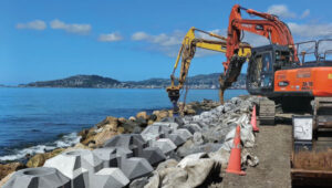
Two main types of material are required for this project. Rock is being used for the revetment (the sloping rock seawall), which will protect the reclamation and the path from the sea while the remaining material is general fill. These are being sourced in Taranaki and Golden Bay with rock from Golden Bay being transported by barge, greatly reducing the number of truck movements.
XBlocPlus units are a unique cost-effective solution for Te Ara Tupua. These blocks are poured in the shape of an ‘X,’ which interlock and stack on top of each other to create a seawall with a steeper incline.
Using these interlocking concrete blocks reduces the seawall’s physical footprint and impact on the marine environment, enabling the project to use less material at a lower cost compared to a rock revetment.
Through this innovation, the project team of engineers and ecologists (Te Ātiawa, Ngāti Maniapoto, Ngāti Tūwharetoa and Ngāti Apa) worked alongside lead cultural designer, Len Hetet to combine cultural and environmental design, which resulted in Te Ripowai, the unique Te Ara Tupua ecological XblocPlus unit. Te Ripowai speaks of the rippling water and connects to a Te Ātiawa whakatauki of guardianship. The guardians must keep the ripples occurring, else water becomes still and life will cease to exist. Te Riopowai includes surface patterns and textures to encourage growth of marine plants.
The Ngā Ūranga to Pito-One pathway shoreline ultimately will have 6,663 of these blocks of varying shapes.
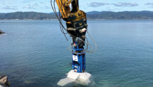
operators of excavators with grapple attachments needed to move eight different block shapes into place with an 80 mm tolerance. Photo: Trimble
Block placement
Placing these blocks with precision and speed initially created some concern for the project team. Operators in excavators equipped with grapple attachments needed to move the units into place, initially about 4 m underwater, to a tolerance of about 80 mm to assure embankment strength. To further complicate the construction, there are eight different block shapes.
It’s a task purpose-built for real-time digital twins and machine guidance, according to the Alliance. With help from SITECH, the survey team looked to its digital assets.
First, Jan du Preez, survey manager with the Te Ara Tupua Alliance, relied on Trimble SketchUp to accurately model the individual blocks. Then, the team combined the Trimble Marine Construction (TMC) System with a digital model of the excavator. Laser scans along the shoreline provided a digital record of the existing conditions. Even the sequential placement of the blocks is planned in the digital space.
On the job, an operator selects a designated block for placement on the screen, then uses the excavator grapple attachment to pick it up. TMC provides real-time feedback on the block’s position, rotation and tilt as the operator navigates to the appropriate position, even underwater.
Du Preez added, “With TMC, the operators can ‘see’ where they are placing them under the water. Because they’re working in an active tidal area with most of the blocks sitting underwater, the idea was to make the process as easy as possible for the operator with highly visual markers on the screen. Every step is color coded, which allows operators to just focus on the colors, rather than trying to see underwater with the naked eye.”
As the block is placed within the 80 mm tolerance required to interlock with the blocks above, the operator records the as-built position, and the screen shows green. The operator then releases the grapple and moves on to the next block.
When asked about efficiency, du Preez noted, “The initial program specified placing 15 blocks per day. We are currently placing between 35 to 45 blocks per day depending on site conditions. We estimate that we’re seeing about three times the productivity compared with more conventional methodology — though I’m still not sure how we would have done this without TMC. We would have had to come up with some kind of visual marker and then perform quality checks with divers. It would have been time consuming and very costly.”
Shared progress
The benefits of the digital workflows to stakeholders, according to du Preez, are many, with transparency being the overarching benefit.
Unlike a traditional contract where owner and project team are separate, in an alliance model the client is an integral part of the team. That said, while NZ Transport Agency, Waka Kotahi, et al., are involved in the everyday running of the project as part of the alliance, they also have a board. “Every time the Alliance board of directors sees our solution, they are completely blown away by what we’ve been doing and how we’re doing it,” du Preez said. They particularly like the regular drone flights that capture progress updates.
“All survey data, models and regular flight imagery are loaded and stored in Trimble Stratus for sharing so that stakeholders always see the latest project status. The entire Alliance really appreciates this level of real-time digital visibility into the project.”
Ngā Ūranga ki Pito-One is on track for completion in 2026. When complete, the Te Ara Tupua will deliver a safe, connected and resilient route, enabling more people to walk or bike, and connect with local paths in both Wellington and the Hutt Valley.
The Air Force Research Laboratory selected Zephr.xyz — a company specializing in augmented position, navigation and timing technologies — to receive a $1.74 million Small Business Innovation Research Direct-to-Phase II contract. Under the contract, Zephr.xyz aims to develop a system for real-time detection of GPS/GNSS jamming and spoofing in contested environments while also geolocating the sources of these attacks.
The company’s Networked GNSS technology, which converts standard mobile phones into a high-fidelity GNSS receiver network, will undergo extensive testing in Ukraine and various U.S. military exercises. Following these trials, the system is set to be integrated with the Department of Defense’s Tactical Assault Kit and the Department of Homeland Security’s Team Awareness Kit.
Zephr.xyz has conducted field research in conflict zones in Ukraine and Israel, revealing limitations in current GNSS interference detection and localization techniques. The company’s solution aims to address these challenges by leveraging distributed mobile devices to create a decentralized sensor network. This network collects raw GNSS measurements to identify electronic attack indicators, which are processed in real time for detection and classification.
The technology also aims to enhance positioning accuracy on TAK devices by integrating GNSS measurements from multiple devices with Position, Velocity, Attitude and Timing data. Zephr.xyz plans to make its detection and classification capabilities available as a software development kit, enabling mobile applications to alert users and improve positioning accuracy in electronic warfare scenarios.
A link to the live event will be sent to you two hours before the event. Your personalized event URL will be automatically generated by the ON24 system. To ensure receipt of the email, please whitelist this email address by adding it to your contacts: [email protected].
This presentation will begin at 1 p.m. EDT on Thursday, March 13. A recording will also be sent to you the following day so you can watch it on-demand.
Audience members may arrive 15 minutes prior to live time. If you have any questions, please contact event producer Halle Reid at [email protected].
Topcon Positioning Systems has become an authorized distributor of Pix4D’s photogrammetry software portfolio, expanding access to high-precision positioning and 3D mapping technologies.
The partnership aims to enhance reality capture solutions across various industries, including surveying, mapping, architecture engineering and construction, energy, utilities infrastructure, public safety, and forensics.
The agreement streamlines the procurement process for end-users by allowing them to access Pix4D‘s advanced photogrammetry software solutions through Topcon’s established global distribution network and ensures comprehensive technical support for users.
Unmanned Traffic Management (UTM) is an air traffic management system for UAVs and other unmanned air taxis or similar aircraft. In the United States, this is in airspace below 400 ft, avoiding other airborne traffic — including other UAVs — and informing authorities of your intended flight plan and how you execute it versus the posted plan.
Where are we on getting such a system? Well, there is an entire directory of nearly 80 UTM suppliers, mostly commercial outfits that offer UAV traffic control of some description for some application – typically like surveying a limited area for construction or maybe a related military application. Few companies possess “full function” UTM capabilities, along with extensive expertise and experience. Each commercial flight needs the approval of the FAA, so software packages include an FAA application to fly and feedback of authorization for the flight plan, as well as approval of operator certification and UAV type. There are complex packages from third-party sources, including NASA-developed UTM, as well as independent commercial systems.
So, how would that work across a major geographical area, such as the entire United States? The FAA and NASA have been working to establish how it could work, at least at a test site in Dallas, Texas.
First, the industry participants in this trial who wanted to operate in the same area had to accede to cooperate. Agreements were signed and means were established for data to flow between the participants, their drones and the FAA (the North Texas Shared Airspace Implementation). The limits of the area near Dallas/Fort Worth for the trial were established as the boundaries in which the parties would fly and, in this case, complete deliveries. The players are Walmart, Amazon, Wing, Manna and ANRA, with FAA and NASA watching carefully.
One of the principal actors in Air Traffic Management (ATM) is ANRA in Washington D.C., with offices in London, UK, and New Delhi, India. With more than 100 customers in 15 countries and more than 200 projects, their UTM/ATM systems are gaining wider experience in several different airspaces and differing traffic compositions. The system is evolving with wider applications as installations worldwide meet new requirements. AAM for eVTOL passenger-carrying aircraft provides mission planning, traffic deconfliction, vehicle tracking, constraints management, route authorization and vehicle registration. EVTOL aircraft will likely fly not only in and out of existing airports but also from new Vertiports specially built for short-hop eVTOL flights across cities. ANRA has already engineered a Vertiport Management System (VMS) to control unmanned and autonomous access to airports and Vertiports alike.
Another unrelated development in the world of UAVs is the phenomenon of high-altitude platform station (HAPS) UAVs and their ground infrastructure. Although flying at altitudes on the edge of space, it is likely special provisions would be required within its associated UTM system to keep track and warn other high-altitude flyers. Nevertheless, the highest-flying commercial aircraft would probably be at an altitude nearly 30,000 ft below HAPS remote Stratospheric perch.
Airbus Zephyr HAPS. (Photo: Aalto)
Airbus company Aalto Haps, based in Farnborough, UK, is now responsible for the manufacture, operation and commercialization of the Airbus Zephyr HAPS vehicle line. Designed to fly for months at a time, with wings covered in solar cells for power, Zephyr has established a world record of 64 days on station in the Stratosphere, and aalot has a target to fly for 200 days regularly.
So, what do you do with such a high-altitude, long-persistence platform? Well, it is like having your own satellite, which you can hang payloads on for tasks such as surveillance, disaster assessment and relief, border control, and numerous precision GNSS applications. With an apparent footprint of close to 3,000 square miles and an appropriate communications relay capability, you have a cell-phone tower in the sky. Perhaps even a partial equivalent to the Space-X Starlink space-based satellite communication service for provision of voice and internet, but seemingly far less infrastructure than the conventional 250 ground cell-towers needed for such an area.
Places starved of phone and internet service — such as Africa — could greatly benefit from flying their kite and gaining wide area coverage. To demonstrate how this capability would work, Aalto recently established a presence in Laikipia, Kenya, building an AALTOPORT ground facility and working with the Kenyan civil aviation authority to qualify Zephyr and its communications role for operations in Kenyan airspace. It is, of course, opportune that Kenya’s location on the equator provides access to one of the most sunny days available to power Zephyr at altitude. Laikipia County is also on a raised plateau, providing Zephyr with an altitude advantage for initial launch. Incidentally, Aalto flew Zephyr for 13 days over Kenya to prove the point.
With the facility in the UK able to build Zephyr-like UAVs every three months or so, Aalto aims to establish a number of hubs (such as the one in Kenya) around the world and operate a number of HAPS aircraft continuously, providing communications and all sorts of services commercially.
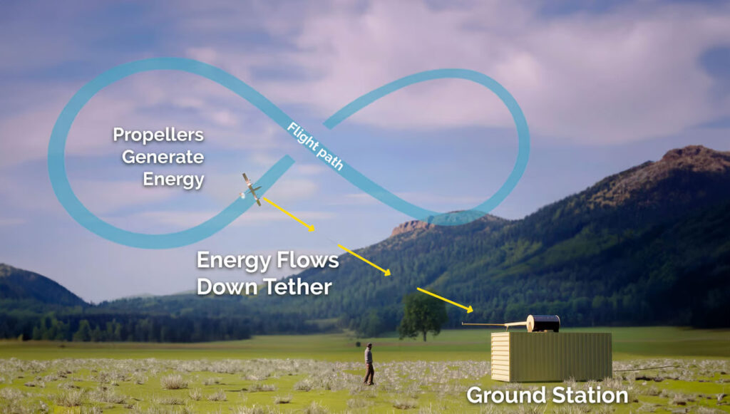
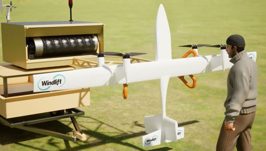
A new startup is investigating the concept of putting a tethered drone in the air with specially designed propellers driven by electric motors. This combination then turns into electricity generators for a particular flight pattern.
Windlift power generation cycle. (Photo Windlift)Transportable power generation. (Photo Windlift)
Initially focused on propeller design, Windlift was established in 2006 and is still based in Durham, North Carolina. Its approach is to use UAVs as a power source — flying repeatedly in a figure of eight, potential energy is converted to electricity in several non-powered phases of flight. The specially designed rotors turn to capture energy in those phases and their prop motors become generators of electric current, which is passed to the ground through the tether wire, to be ultimately supplied to the grid.
However, this setup could be portable, making it suitable for a small military or research team in the field needing power. This portability could be related to a $30 million contract Windlift has received from the U.S. Naval Research Laboratory, which is interested in technologies that the Navy and Marine Corp could use. Under the contract, the building and testing of a working prototype and demonstration to the Department of Defense is required. According to Windlift, this is a successful result of several earlier, smaller Small Business Innovation Research contracts to helped develop the necessary technological elements of today’s system.
Commercially, the UAV power generation approach appears to be extremely cost-effective versus the costs associated with today’s wind farms of huge wind turbines. Not only is the construction cost of each tower, its generator, and the huge blades very high, but the wear and tear of operations over time require expensive maintenance. Meanwhile, the UAV, while still in its infancy with lots of reliability and weatherproofing to be accomplished, has the potential to reduce power generation costs by up to 80%, Windlift said.
This month’s UAS news indicates how UTM is well along the path towards managing UAV integration into the National Airspace System, HAPS high-altitude aircraft may be back in the news as Aalto moves forward with commercialization plans, and yet another application for UAVs appears to involve a new potential approach for power generation. A pretty wide range of unmanned requirements and applications.
MIKROE has unveiled the GNSS RTK 5 Click, a compact add-on board for high-precision positioning and navigation demands. It features the UM980, an all-constellation multifrequency RTK positioning module from Unicore, with the advanced NebulasIV SoC for enhanced performance.
It supports Swift Navigation’s Skylark precise positioning service, multiple GNSS constellations, and RTK positioning for centimeter-level accuracy. The board also features JamShield technology for robust performance in challenging environments, USB connectivity for easy configuration and visual status indicators for module status and GNSS signal reception.
It can be used for a variety of applications, including surveying and mapping, precision agriculture, UAVs, autonomous robots and autonomous driving.