TerraGo is partnering with RazorTek, a GIS and remote-sensing consulting firm specializing in design, development and automation of complex systems for spatial data display and analysis. RazorTek will deploy TerraGo Edge for customers looking to replace GPS handhelds with a mobile app that integrates directly with Esri’s ArcGIS.
“We see a great opportunity to help our customers utilize TerraGo Edge for field data collection on their smartphones and tablets,” said Dan Rodriguez, CEO, RazorTek. “The nice thing about TerraGo Edge is that it replaces proprietary GPS handhelds with a simple mobile solution at a fraction of the cost, and it works seamlessly with Esri ArcGIS out of the box.”
“RazorTek is an industry expert for deploying advanced remote sensing and GIS solutions,” said John Timar, vice president, TerraGo. “TerraGo Edge gives the RazorTek team a cost-effective mobile solution that can deliver cm-level accuracy or whatever the RazorTek customer needs, while leveraging their existing ArcGIS investment.”
RazorTek is an authorized reseller of TerraGo products and also offers a range of geospatial technology software and services including GIS services, aerial photography, satellite imagery and LiDAR.
Kalashnikov produces a well-known assault rifle. The acquisition of the UAV companyZALA Aero is part of the company’s development strategy through 2020, according to a statement released to Defense News.
“Based off Kalashnikov Concern and ZALA Aero company, we plan to develop and manufacture drones, mobile and earth-based management stations,” said Aleksey Krivoruchko, Kalashnikov Concern CEO.
“Our main product here will be intelligence-gathering pilotless airplanes, helicopters and aerostats. The decision to purchase control stake of ZALA Aero to widen our product line has been made as a part of the strategy of Kalashnikov corporate development through the year 2020 and as a part of the process of developing new sectors of our market.”
The UAVs will operate to secure state borders, intelligence gathering and rescue operations, as well as special operations, the report states.
Volvo Cars has a complete system solution that makes it possible to integrate self-driving cars into real traffic, with ordinary people in the driver’s seat. The automaker presented its planned system in an online press conference Feb. 19.
“We are entering uncharted territory in the field of autonomous driving,” said Peter Mertens, senior vice president of Research and Development, Volvo Car Group. “Taking the exciting step to a public pilot, with the ambition to enable ordinary people to sit behind the wheel in normal traffic on public roads, has never been done before.”
As the Drive Me project enters its second year, Volvo is moving toward its goal of placing 100 self-driving cars in the hands of customers on selected roads around Gothenburg by 2017. The public pilot — a collaboration between legislators, transport authorities, a major city and a vehicle manufacturer — is a central component of Volvo’s plan to achieve sustainable mobility and ensure a crash-free future.
Early prototype cars are now being tested on the DriveMe route in and around Gothenburg, Sweden.
Volvo’s production-viable autonomous driving system is based on a complex network of sensors, cloud-based positioning systems and intelligent braking and steering technologies.
“Autonomous driving will fundamentally change the way we look at driving. In the future, you will be able to choose between autonomous and active driving,” Mertens said. “This transforms everyday commuting from lost time to quality time, opening up new opportunities for work and pleasure.”
Volvo’s autopilot system is designed to be reliable enough to allow the car to take over every aspect of driving in autonomous mode, Volvo said. The technology advances a crucial step beyond the automotive systems demonstrated so far since it includes fault-tolerant systems, the carmaker said.
“It is relatively easy to build and demonstrate a self-driving concept vehicle, but if you want to create an impact in the real world, you have to design and produce a complete system that will be safe, robust and affordable for ordinary customers,” said Erik Coelingh, technical specialist at Volvo Cars.
The main challenge is to design an autopilot that is robust for traffic scenarios as well as for technical faults that may occur. The driver can’t be expected to suddenly intervene in a critical situation. Initially, the cars will drive autonomously on selected roads with suitable conditions, such as without oncoming traffic, cyclists or pedestrians.
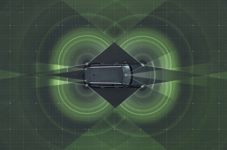
Volvo’s system generates exact positioning and a complete 360° view of the car’s surroundings through a combination of radars, cameras and laser sensors. A network of computers processes the information, generating a real-time map of moving and stationary objects in the environment.
“Making this complex system 99 percent reliable is not good enough. You need to get much closer to 100 percent before you can let self-driving cars mix with other road users in real-life traffic,” Coelingh said. “Here, we have a similar approach to that of the aircraft industry. Our fail-operational architecture includes backup systems that will ensure that the autopilot will continue to function safely if an element of the system were to become disabled.”
For example, the probability of a brake system failure is very small, but a self-driving vehicle needs a second independent system to brake the vehicle to a stop, because it is unlikely that the driver will be prepared to press the brake pedal.
On the road, the complete technology solution is designed to handle even the most complicated scenarios, from smooth commuting to heavy traffic and emergency situations, Volvo said. “Just as good drivers would, potentially critical situations are approached with sensible caution. In a real emergency, however, the car reacts faster than most humans,” Coelingh said.
When autonomous driving is no longer available — because of weather, technical malfunction or the end of the route has been reached — the driver is prompted by the system to take over again. If the driver is incapacitated for any reason and does not take over in time, the car will bring itself to a safe place to stop.
Volvo expects that autonomous driving could cut fuel consumption, improve traffic flow, and open up possibilities for urban planning and more cost-efficient investments in infrastructure.
“Developing a complete technological solution for self-driving cars is a major step. Once the public pilot is up and running, it will provide us with valuable knowledge about implementing self-driving cars in the traffic environment, and help us explore how they can contribute to sustainable mobility,” Coelingh said. “Our smart vehicles are a key part of the solution, but a broad societal approach is vital to offer sustainable personal mobility in the future. This unique cross-functional cooperation is the key to a successful implementation of self-driving vehicles.”
Drive Me system components:
The 76-GHz frequency-modulated, continuous wave radar is placed in the windscreen and combined with a camera to detect objects on the road. Four radars behind the front and rear bumpers locate objects in all directions. Long-range radars in the rear ensure a good rearward detection of vehicles in parallel lanes.
Sensor technologies. Volvo Cars is developing a holistic solution that generates exact positioning and a complete 360-degree view of the car’s surroundings. This is achieved by a combination of multiple radars, cameras and laser sensors. A redundant network of computers processes the information, generating a real-time map of moving and stationary objects in the environment.
Precise positioning is based on this surround information together with GPS and a high-definition 3D digital map that is continuously updated with real-time data. The system is reliable enough to work without requiring driver supervision.
Combined radar and camera. The combined 76-GHz frequency-modulated continuous wave radar and camera placed in the windscreen is the same as that in the new XC90. This system reads traffic signs and the road’s curvature and can detect objects on the road such as other road users.
Surround radars. Four radars behind the front and rear bumpers (one on each corner of the car) are able to locate objects in all directions. By sweeping both left and right, transmitting waves that bounce off signs, poles, and tunnels, they monitor a full 360-degree around the car.
360-degree surround vision. Four cameras monitor objects in close proximity to the vehicle. Two are under the outer rear-view mirrors, one is in the rear bumper and one is in the grille. Besides detecting objects at close range, these cameras monitor lane markings. The cameras have a high dynamic range and can handle quick changes in lightning conditions, such as when entering a tunnel.
Multiple beam laser scanner. This sensor system is placed in the front of the vehicle, below the air intake. The scanner can identify objects in front of the car and ensures very high angle resolution. It can also distinguish between objects. The laser sensor has a range of 150 meters for vehicles and covers a 140-degree field of view.
Trifocal camera. A trifocal camera placed behind the upper part of the windscreen is three cameras in one, providing a broad 140-degree view, a 45-degree view and a long-range, yet narrow, 34-degree view for improved depth perception and distant-object detection. The camera can spot suddenly appearing pedestrians and other unexpected road hazards.
Long-range radars. Two long-range radars placed in the rear bumper of the car ensure a good rearward field of view. This technology is useful when changing lanes because it can detect fast-moving vehicles approaching from far behind.
Ultrasonic sensors. Twelve ultrasonic sensors around the car are used to identify objects close to the vehicle and support autonomous driving at low speeds. The sensors are based on the technology used for current park-assist functions enhanced with advanced signal processing. This technology is useful for detecting unexpected situations, such as pedestrians or hazards on the road close to the car.
High-definition 3D digital map. A high-definition 3D digital map provide the vehicle with information about the surroundings, such as altitude, road curvature, number of lanes, geometry of tunnels, guard rails, signs, and exits. The position geometry is in many cases at centimeter level.
High-performance positioning. The high-performance GPS is one part of the positioning control that is enhanced by a combination of an advanced GPS, a three-degrees-of-freedom accelerometer and a three-degrees-of-freedom gyro. By matching the 360-degree image created by the multitude of sensors with the map image, the car will get the information about its position in relation to the surroundings.
By combining the information from the sensors and the map, the Drive Me car is able to choose the best course in real time, factoring in variables such as the curvature of the road, speed limit, temporary signs and other traffic.
Cloud services. The cloud service is connected to the traffic authorities’ control center. This ensures that the most up-to-date traffic information is always available. Control center operators also have the ability to tell the drivers to turn off the autonomous drive mode if necessary.
Driverless cars are now traveling Britain’s public roads, according to a report in the Providence Journal. Four prototype self-driving cars took to the country’s highways, launching Britain’s first public trials. Still, with regulatory and legal hurdles, officials said fully driverless cars are unlikely to be used on British roads until 2030.
Four types of autonomous vehicles are being tested, including a shuttle that looks like a larger golf cart and a compact two-seater “pod.” Journalists took rides on the shuttle, which traveled a public square outside central London’s O2 Arena.
The project was “still in the early days,” Transport Minister Claire Perry told the Associated Press, but she added the new technology has the potential to make roads safer and attract global investment.
Driverless cars are also being tested in U.S. cities by companies including Google, and Apple and Sony are at least exploring autonomous vehicles. Meanwhile, automakers such as Audi, Mercedes-Benz and Nissan are developing autonomous cars, and Volvo expects to test its self-driving cars on customers by 2017. The widely discussed goal is to have autonomous vehicles on the market by 202o.
The NSDI Report Card describes the condition of the nation’s information about roads, water, land, air, bridges, dams, topography, and more. It highlights the poor condition of the nation’s information about our infrastructure at a time when the National Governors Association Chair, Gov. Hickenlooper of Colorado, is calling on states to lead the way in “delivering results” on government promises, COGO said in a statement.
The report card encourages government agencies to improve the national spatial data infrastructure to better support efficient government operations at all levels. “The goal of the report card evaluation is to bring attention to the need for current and accurate geospatial data for the nation,” Geringer said. Geringer is chair of the panel that drafted the report card for COGO.
“Governor Hickenlooper’s ‘Delivering Results’ initiative with the National Governors Association is dependent on this information to make state governments work in the most efficient, cost-effective way possible,” Geringer said. “Government agencies at every level are dependent on this data, as are private-sector businesses.”
The report card is the first of a series of periodic report cards by COGO. “We did not include cost estimates for completing the NSDI or bringing it to a specified level,” Geringer said. “We need state and federal government to make improvement of the NSDI a high priority so the nation can make significant, rapid progress on jobs, education, economic growth, public safety, energy, natural resource management, health care, agriculture, transportation and other areas. This information will also allow us to track and manage our progress in all these areas, reducing duplication and ensuring sustainability of our efforts over time.”
“On a daily basis, most people encounter and understand the need for maintenance of the nation’s roads, bridges, dams, power lines, pipelines, telecommunications network, and all the rest of our physical infrastructure,” COGO said in a statement. “The local, state and federal government agencies along with private companies that maintain the infrastructure must know where maintenance is needed, when it’s needed, and what needs to be done to plan it out in the most cost effective manner. There are millions of miles of roads, pipelines, and the like to maintain. That means a lot of information is needed and that information must be accurate and up-to-date.”
In addition to maintenance, COGO said accurate and up-to-date information about the nation’s infrastructure is essential for:
getting ambulances to emergencies faster and evacuating people in the path of natural disasters.
monitoring and treating public health and environmental issues.
responding to the need for jobs, health care, foster homes, and other social services.
planning the location of schools, shelters, retail stores, and promoting economic growth.
managing traffic flow, and expansion of mass transit and utilities.
COGO member organizations represent 170,000 professionals who develop and use spatial information about the nation’s physical infrastructure. Member Organizations include: American Society of Civil Engineers (ASCE), American Society for Photogrammetry and Remote Sensing (ASPRS), Association of American Geographers (AAG), Cartography and Geographic Information Society (CaGIS), Geographic and Land Information Society (GLIS), Geographic Information Systems Certification Institute (GISCI), International Association of Assessing Officers (IAAO), Management Association for Private Photogrammetric Surveyors (MAPPS), National Society of Professional Surveyors (NSPS), National States Geographic Information Council (NSGIC), United States Geospatial Intelligence Foundation (USGIF), University Consortium for Geographic Information Science (UCGIS), and Urban Regional Information Systems Association (URISA).
Drone World Expo, an event for commercial drone technologies and applications, is partnering with MAPPS to bring together stakeholders, constituents, and all levels of government in the surveying, mapping, and geospatial fields. The MAPPS Conference will be held as a part of Drone World Expo, set for November 17-18 at the San Jose, Calif., Convention Center.
“With all of the exciting developments taking place in the UAV industry, we are thrilled to bring the breadth and depth of knowledge from MAPPS to our event,” said Joel Davis, CEO, JD Events, producers of the show. “Attendees to the MAPPS conference will have free access to the Drone World Expo trade show floor, general sessions and networking events, and we look forward to welcoming their members to this must-attend event.”
The MAPPS Conference will be a forum for discussion on issues and policies, sharing of information and provision of education, and collaboration, specifically related to the geospatial applications of UAV technology.
“MAPPS is thrilled to be part of Drone World Expo,” said John Palatiello, MAPPS executive director. “We believe UAVs will play an integral role in the future of surveying and mapping, and it is vitally important we lead the discussion in terms of investment, technology, applications and regulations. MAPPS looks forward to presenting quality content on the geospatial market for UAVs at Drone World Expo.”
In addition to the MAPPS Conference, Drone World Expo will also offer a two-day conference that will feature sessions and case studies addressing data collection and processing, sensors, piloting and safety management, FAA updates, certification standards, and commercial strategies, and will offer informative sessions on the impact drones are having on geographic information systems (GIS), Big Data and the Internet of Things (IoT).
The Drone World Expo Conference is being developed with the help of an advisory board on which Palatiello serves.
The Routescene LidarPod 3D mapper, a self-contained turnkey solution new to the market, is being showcased for the first time in the United States at the International Lidar Mapping Forum in Denver, Colo., Feb. 23-25. Routescene is based in Edinburgh, United Kingdom.
The flexible LidarPod was developed for use on unmanned aerial vehicles, but can also be fitted onto any mobile platform such as a car or boat. The flexibility makes it attractive for many sectors and situations where accurate mapping is essential but difficult to achieve, enabling surveys to be conducted in areas that previously would not have been considered, Routescene said.
The technology offers a non-intrusive method to obtain detailed and precise geo-referenced 3D datasets, Routescene said. LidarPod 3D can be used for 3D mapping; powerline inspection; scoping, planning and management of mines; forestry design, management and operation; large-scale topographic surveys; and city planning and management.
Routescene LidarPod costs less than a vehicle-based mobile mapping system, Routescene said. The turnkey solution includes LidarViewer, specially developed software to turn the raw data into valuable business information. It enables users to convert, analyze and filter huge volumes of point cloud data to improve productivity and workflow. Powerful filters enable users to extract relevant data for use in third party software, such as GIS and CAD packages, which are unable to cope with such large data volumes.
Fleetmatics Group now offers new features for its mobile field service management solution Fleetmatics WORK. The enhancements help businesses to operate more efficiently and maximize their resources, the company said. Fleetmatics is a global provider of mobile workforce solutions for service-based businesses.
This latest release dramatically accelerates time to cash for SMB operators by embedding a payment link directly into the emailed invoice that is generated. With this new online payment powered by Stripe, Fleetmatics WORK closes the loop between job completion and payment. Jobs can now be invoiced from the field instantly via email and transactions can be processed securely in real time.
Fleetmatics WORK has added integrations with QuickBooks Online in the U.S. and MYOB AccountRight Live in Australia and New Zealand. Now, when jobs are completed, the invoices flow seamlessly from Fleetmatics WORK to the user’s accounting system and updated client information is sent between the systems to keep all data in sync, Fleetmatics said.
Business owners now have additional tools to manage fieldworkers. As service businesses grow, it becomes increasingly important for them to have manageable views of their field. New fieldworker tags in Fleetmatics WORK give dispatchers clear visibility to sort schedules and make assignments based on best fit.
“Our mission is to help customers achieve greater levels of productivity, service and efficiency,” said Jonathan Durkee, Vice President of Product Management for Fleetmatics. “With the new online payments, seamless accounting integrations and increased fieldworker visibility we’re enabling field service businesses to drive even stronger results.”
Free training and ongoing support is available to all users through Fleetmatics’ award-winning customer service, which provides education and best practices for transforming data into actionable business intelligence.
MAPPS has come out in support of the proposed framework of regulations that the Federal Aviation Administration (FAA) has proposed for commercial UAV use. The FAA’s rules would allow routine use of certain small unmanned aircraft systems (UAS) for commercial purposes.
MAPPS Executive Director John Palatiello issued the following statement about the Notice of Proposed Rulemaking (NPRM) issued by the FAA concerning operation and certification of Small Unmanned Aircraft Systems (UAS):
“The proposed rules issued by the FAA for the commercial use of small unmanned aircraft systems (UAS) will provide considerable potential business applications for MAPPS member firms in the aerial survey profession. According to the FAA, the following are examples of possible small UAS operations that could be conducted under the proposed regulations: crop monitoring/inspection; research and development; educational/academic uses; power-line/pipeline inspection in hilly or mountainous terrain; antenna inspections; aiding rescue operations such as locating snow avalanche victims; bridge inspections; aerial photography; and wildlife nesting area evaluations.
“In the past, MAPPS has worked closely with the FAA to enable the commercial use of small UAS (which, as defined by statute, is an unmanned aircraft weighing less than 55 pounds) for aerial survey purposes through various mechanisms, such as special airworthiness certificates, exemptions, and certificates of waiver or authorization (COA). MAPPS will continue to support the proposed federal regulations, which will provide for the next phase of integrating small UAS into the national airspace system.”
MAPPS will provide comments to the FAA concerning the proposed rules, and the association will continue to educate its member firms about operational limitations of small UAS in order to maintain the safety of the national airspace system and ensure that they do not pose a threat to national security.
As a member of a Aviation Rulemaking Committee (ARC) working group advising the FAA on Beyond Visual Line of Sight (BVLOS) regulations, Palatiello added, “Prompt implementation of the small, line-of-sight UAS rules will help strike the necessary balance between aviation safety and business development, but the next set of rules, governing beyond visual line of sight, need to be developed and implemented as soon as possible as well.”
“MAPPS has made the case that aerial geospatial data acquisition using UAS provides significant societal benefit and is NOT a threat to individual citizen privacy, and should be permitted to operate within a reasonable regulatory framework,” MAPPS Aviation Counsel Gregory S. Winton said. “It contributes to E911 emergency response and police dispatching systems, precision agriculture, environmental protection, emergency ‘blue tarp’ surveys to support hurricane response, engineering, transportation and infrastructure, electoral district maps, and many other applications. Geospatial data enables the delivery of critical government services and valuable business applications that citizens are demanding. The proposed FAA rule will enable this profession, which has an exemplary safety record and vast experience in manned aerial operations, to use of UAS safely, effectively and economically.”
All Phase One Industrial aerial cameras now fully support the IGI AEROcontrol, GNSS/IMU positioning system, the companies announced. Aerial camera models include iXA-R, iXA, and iXU.
Phase One aerial cameras are high-quality industrial-grade camera systems, which have found wide success in the photogrammetry market, both among end users and OEM integrators.
AEROcontrol is a GNSS/IMU system for the precise determination of position and altitude of multiple airborne sensors. Beside the choice of MEMS- and FOG-based IMUs, the system is also suitable for mobile mapping applications. Used together with IGIplan and CCNS-5, a complete and comprehensive solution for mission planning, aircraft guidance with sensor management and geo-referencing is available to Phase One aerial camera users.
“With the addition of IGI’s AEROcontrol, users of Phase One aerial cameras are able to use IGI’s popular AEROcontrol, GNSS/IMU positioning system with a single camera or as part of an array,” said Dov Kalinski, general manager of Phase One Industrial.
“With the integration of the IGI AEROControl GNSS/IMU with the Phase One aerial cameras, all Phase One users now have access to geo-referencing with different IGI IMU models and IMU-based, precise stabilized mount control. This smart geospatial solution helps users obtain the best possible aerial photography results,” added Philipp Grimm, IGI marketing and sales manager.
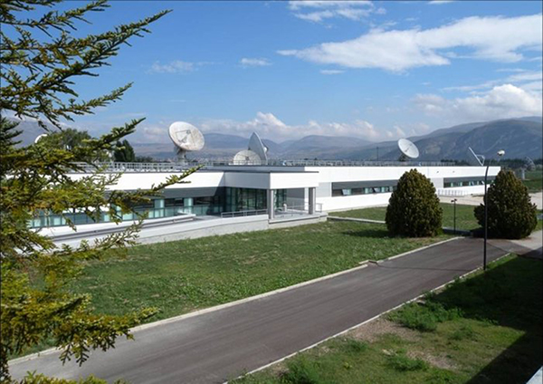
Galileo’s Ground Mission Segment in the Fucino Control Centre in Italy oversees Galileo navigation services and satellite payload operations.
News from the European Space Agency
In Roman times the milestone was the central method of navigation, with all distances fixed from a ‘golden milestone’ in the imperial capital. Today, navigation satellites have become the modern equivalent of milestones — but Rome still has a role to play.
Inside the Galileo System Evaluation Equipment facility, based at Thales Alenia Space in Rome.
The Thales Alenia Space plant in the eastern suburbs of Rome is home to the Galileo System Evaluation Equipment facility, which provides a troubleshooting platform for the Galileo ground network and an assessment of the performance of Europe’s under-construction satnav constellation.
Based in the main plant building, it is equipped with a secure data link to the Galileo Control Centre in Fucino, 90 km away, which oversees Galileo navigation services. This link gives it direct access to all the data gathered by the global ground segment, from the sensor station data to the navigation messages uplinked to the satellites, including satellite orbits and onboard clock corrections.
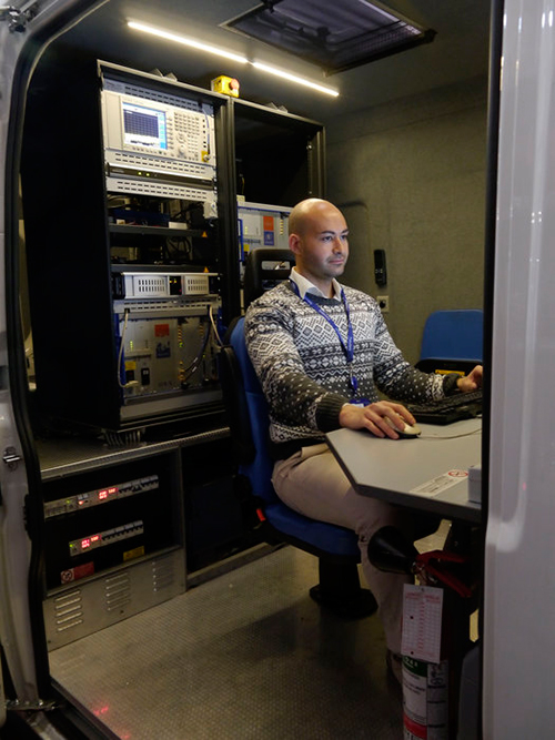
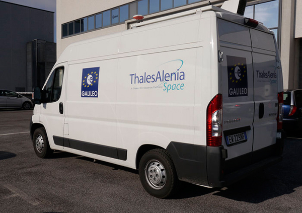
The facility can then apply separate software to these inputs, rather than that used in the Galileo Mission Segment, to provide a “second opinion” on Galileo performance. In addition, a van measures Galileo performance in the field, gathering data across a range of vehicle and rural environments.
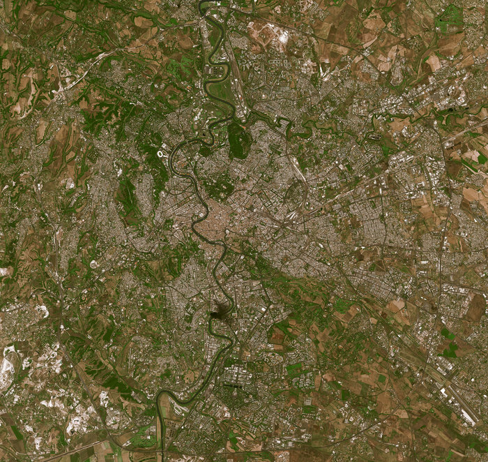
The River Tiber flows through the historic centre of Rome, seen in high-resolution detail by France’s Spot-5 satellite.
“The facility is being routinely operated by the Thales Alenia Space team,” explains Enrico Spinelli, overseeing it on the ESA side. “It is being upgraded to automatically process the data received from the Galileo control centres, perform troubleshooting analyses and provide inputs for the monthly Early Service Key Performance Indicators report. These reports are provided in turn to the European Commission’s European Global Navigation Satellite System Agency, as part of Galileo’s Early Services preparatory activities.”
The facility made the Rome area one of the two main centres of activity during Galileo’s In-Orbit Validation phase, along with the ESA’s ESTEC technical centre in Noordwijk, the Netherlands. In-Orbit Validation was the extensive system testing performed on the ground during late 2012 and early 2013 to ensure the embryonic four-satellite system was performing as designed, including Galileo’s historic first position fix of longitude, latitude and altitude on March 12, 2013.
The Galileo System Evaluation Equipment facility hosted at Thales Alenia Space in Rome is equipped with a van measures Galileo performance in the field, gathering data across a range of vehicle and rural environments.
“The facility was developed for that phase, but has performed so well that it was decided to keep it in operation during succeeding phases,” adds Enrico. “Along with its intended use in monthly reporting, its direct access and processing of Galileo Control Centre data will make it a powerful tool for system troubleshooting for both Galileo’s upcoming services. It can give us independent analyses of factors such as the availability and quality of data from Galileo Sensor Stations and the Orbit Determination and Time Synchronisation process which keeps the overall Galileo system in sync.
“It can also allow us to check the accuracy of software models used to compensate for ionospheric delay, the accuracy of almanacs charting satellite orbital positions and to analyze the efficiency of the ground-to-satellite contact plans for the uplink of the navigation message which the satellites rebroadcast, even to verify the navigation message is being broadcast in its correct structure.”
The improved facility should help to ensure the timely and reliable introduction of initial Galileo services, planned in 2016.
To meet the needs of high-accuracy field data collection and better workflow with modern GNSS technology, Supergeo’s latest SuperSurv GIS mapping app allows users to connect with and operate external Bluetooth GNSS devices. The app also elevates field-work efficiency with new averaging algorithms.
SuperSurv is designed for field data collection on Android and iOS-powered devices. Integrating with GIS and GPS technologies, SuperSurv provides functions like Map Display, Query, Measure, and supports to overlay OpenStreetMap as the basemap. Also, users can capture point, line and polygon features and attribute data, and save the data as SHP or GEO format in both offline and online modes.
With the new external GNSS device connection function, users can choose between internal positioning information and an outer GNSS source via Bluetooth. When pairing the GNSS receiver with an Android device, SuperSurv allows users to fully control and present detailed messages of navigation within system status. In addition, data collection via GNSS is enhanced with options such as a coordinate data averaging function or vertex collecting threshold, bringing users modernized and highly accurate field survey experience.
The external GNSS device connection and advanced data-collecting functions are fully supported and available with the SuperSurv Pro version. For SuperSurv M3 users, the newly added functions come as an optional plug-in that users can purchase and download.