Blog

  • Canadian Science Minister Announces Grant to Langley’s UNB Lab

    Canadian Science Minister Announces Grant to Langley’s UNB Lab

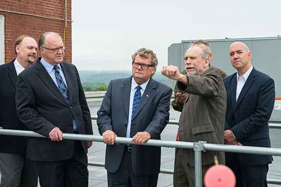
    Professor Langley (center) discusses the UNB geodesy program with Canadian Science Minister Ed Holder (second from left.)
    Professor Langley (fourth from left) discusses the UNB geodesy program with Canadian Science Minister Ed Holder (third from left.)

    The Canadian Minister of State for science and technology, Ed Holder, visited the University of New Brunswick on July 28 to announce the awarding by the Natural Sciences and Engineering Council of $2.4 million to 28 UNB researchers.

    He was joined by Keith Ashfield, member of Parliament for Fredericton, where UNB is based, and Craig Leonard, the New Brunswick Minister of Energy and Mines.

    A highlight of the visit was a tour of the Department of Geodesy and Geomatics Engineering to see the work of Prof. Richard Langley and his students. Langley received $170,000 in Natural Sciences and Engineering Research Council (NSERC) funding in the competition. The funding will support the work of his group in improving augmented multi-constellation satellite-based precise positioning in a wide range of environments. Langley is GPS World’s Innovation editor, a post he has held since the magazine’s inception.
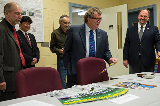
    Canadian Science Minister Ed Holder looks at GPS World magazine, which has featured Innovation columns edited by Richard Langley for more than two decades.
    Canadian Science Minister Ed Holder looks at GPS World magazine, which has featured Innovation columns edited by Richard Langley for more than two decades.

    Although GPS was the first widely available satellite navigation system, it has now been joined by the Russian GLONASS system, and will soon be accompanied by the European Galileo system, the Chinese BeiDou system, and the Japanese QZSS — all of which have test satellites now in orbit. There are interesting problems to be solved in gaining maximum benefits from this plethora of GNSS for precise positioning and navigation, and Langley and his team will address a number of them.

    The team is also involved in the analysis of data from the GPS-based instrument on the Canadian CASSIOPE scientific satellite launched at the end of September 2013. The instrument, which precisely determines the position of the satellite and provides information on the state of the Earth’s ionosphere, was designed at UNB.

    The NSERC Discovery Grants Program is an integral component of the government’s efforts to develop, attract and retain the world’s most talented researchers at Canadian universities. The program funds discovery research in a multitude of scientific and engineering disciplines, which builds a broad base of research capacity across the country.

    Professor Langley gave the following presentation at the NSERC Discovery Grants Scholarships Rollout Announcement at UNB on July 28:
  • Trimble Offers GNSS Reference Receiver, Seismic Recorder

    Trimble Offers GNSS Reference Receiver, Seismic Recorder

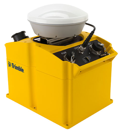
    The Trimble SG160-09 SeismoGeodetic system.
    The Trimble SG160-09 SeismoGeodetic system.

    Trimble has introduced an integrated GNSS reference receiver, broadband seismic recorder and a force-balance triaxial accelerometer for infrastructure and precise scientific applications.

    The Trimble SG160-09 SeismoGeodetic system provides real-time GNSS positioning and seismic data for earthquake early warning and volcano monitoring as well as infrastructure monitoring for buildings, bridges, dams, as well as other natural and manmade structures.

    The announcement was made at the Second European Conference on Earthquake Engineering and Seismology (2ECEES) in Istanbul, Turkey.

    The Trimble SG160-09 SeismoGeodetic system combines the innovation, reliability and data integrity of both the Trimble and REF TEK brands into a single instrument, Trimble said. The system integrates seismic recording with GNSS geodetic measurement in a single compact, ruggedized package. It includes a low-power, 220-channel GNSS receiver powered by the latest Trimble-precise Maxwell 6 technology and supports tracking of both GPS and GLONASS signals plus the Galileo E1 frequency.

    The system includes both the SG160-09 and utilization of Trimble’s CenterPoint RTX correction service, which provides on-board GNSS point positioning. Based on Trimble RTX technology, the service utilizes satellite clock and orbit information delivered over cellular networks or Internet Protocol (IP), allowing cm-level position displacement tracking in real-time anywhere in the world. The SG160-09 system will be available for purchase without the RTX correction service for those applications using real-time kinematic (RTK) positioning.

    The seismic recording sensor includes an ANSS Class A, low-noise, force-balance triaxial accelerometer with the latest, low-power, 24-bit A/D converter, which produces high-resolution seismic data. The internally built accelerometer has +/- 4g full scale output, large linear range, high resolution and sensitivity, which makes it ideal for both portable and permanent deployment. The SG160-09 processor acquires and packetizes both seismic and geodetic data and transmits it to system operators using an advanced, error-correction protocol with back-fill capability providing data integrity between the field and the processing center.

    The SG160-09 system is ideal for earthquake early warning studies and other hazard mitigation applications, such as volcano monitoring, building, bridge and dam monitoring systems. The SG160-09 system features a variable size industrial grade USB drive to support real-time telemetry data transmission. In the event of a telemetry link outage, the data is stored on the USB drive and can be re-transmitted to the centralized processing station as soon as the communication link comes back up, allowing no data loss during the system operation.

    The Trimble SG160-09 system is optimized for field use with instrument mounted or externally mounted GNSS antenna configurations. The lightweight yet rugged SG160-09 consumes very little power and can be used for projects with remote connectivity and in extreme weather conditions. Because the SG160-09 combines both GNSS and strong motion in a single instrument, site installation time is reduced, data communications flow through a single pathway, and station power infrastructure is streamlined, making the SG160-09 a cost competitive solution compared to other systems on the market today. It has an IP67 rating, which means it is sealed against dust and can be submerged in water up to a meter for approximately 30 minutes. The SG160-09 also meets MIL-STD 810F standard for drops, vibration and temperature extremes.

    “The SG160-09 is another example of Trimble’s on-going focus in GNSS and seismic technology for the scientific and engineering communities,” said Ulrich Vollath, general manager for Trimble’s Infrastructure Division. “Trimble has developed a combined state-of-the-art GNSS receiver with a high-dynamic range, low-noise accelerometer that provides dynamic monitoring with the flexibility required for today and tomorrow’s challenges.”

    The Trimble SG160-09 SeismoGeodetic system is expected to be available in the fourth quarter of 2014.

  • Students Create California Climate Change Map

    A group of Stanford University students has created a story map to show how forces of global change are manifested locally throughout California.

    The map was created to inform the public, businesses and policymakers about the human dimensions of environmental change. By clicking a datapoint on the map, a narrative is revealed. Categories include climate disruption, population change, biodiversity loss, pollutants, and invasives & diseases.in the creation o

    The students were led by graduate student instructors Alexis Mychajliw and Melissa Kemp under the guidance of Professor Elizabeth Hadly.

    View the map here.

    Geo-Map-CA-ClimateChange

    View the map here. this map. Last updated 8/2014.

  • Grasshopper3 Vision Camera Launched for Scientific Imaging

    PointGrey-Grasshopper3-Camera-W

    Point Grey, a designer and manufacturer of innovative, high-performance digital cameras, has added a 4.1-megapixel global shutter CCD to the Grasshopper3 family of high-quality, high-resolution USB 3.0 cameras.

    The new Grasshopper3 GS3-U3-41S4 models are based on color and monochrome versions of the Sony ICX808, a 1/1.8-inch global shutter EXview HAD CCD II sensor featuring 3.1 micron square pixels , and capable of  2048 x 2048 pixel resolution at 18 FPS.  The Sony ICX808 EXview HAD CCD II sensor provides excellent quantum efficiency of over 72% and its unique square aspect ratio makes it ideal for scientific applications such as microscopy and ophthalmology, and industrial applications such as AOI and electronics inspection, Point Grey said.

    Like all Point Grey USB 3.0 cameras, the Grasshopper3 uses a proprietary USB 3.0 link layer and frame buffer-based architecture for optimal performance and reliability. The Grasshopper3 uses an advanced image processing pipeline to enable look up table, gamma correction, pixel binning and USB3 Vision support.

    “We are excited to expand our Grasshopper3 USB3 Vision camera lineup with the latest sensor technology,” said Michael Gibbons, director of Sales and Marketing at Point Grey. “Applications such as ophthalmology rely on a square aspect ratio and will therefore benefit from the full resolution of the GS3-U3-41S4 camera.”

  • Topcon Offers 3D Indicate Grade System

    Topcon Offers 3D Indicate Grade System

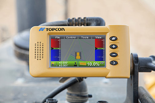
    I-33_Topcon-WTopcon Positioning Group has announced a multi-platform 3D indicate grade system, the i-33. The new system features GNSS technology and a graphical display designed to provide a powerful indicate system at an economical price.

    The i-33 allows for quick installation and easy operation on many types of grading and earth-moving machinery, according to Topcon. It is designed for use on a dozer, scraper or any type of machinery used for cut or fill operations.

    “The new system brings the productivity of GNSS-based 3D grade control for all types of applications,” said Kris Maas, Topcon’s manager of machine control product marketing.

    “Indicate GNSS systems have not been an economical reality for many contractors or types of work. In other words, the return on investment for a traditional 3D-MC system did not make it practical for bulk earthmoving or less utilized equipment,” Maas said. “With i-33, the game has changed. Its low cost and quick installation make it the perfect solution for use on multiple pieces of equipment or even sharing between machines. Basically, it eliminates over- or under-cutting and ensures material is moved exactly where it needs to be the first time.”

    The GX-30 graphical display control box keeps the operator “visually informed as to final grade so adjustments can easily be made, eliminating redundant passes and helping to further reduce the need for onsite grade checking,” Maas said.

    The system also includes the new MC-i3 GNSS receiver with Vanguard technology, offering single or dual GNSS antenna configurations, allowing the system to work in a wide variety of applications. The MC-i3 also allows connection to Topcon’s Sitelink3D site management solution that provides real-time data control, machine tracking, reporting and planning in one solution to maintain conformance and improve productivity through all job phases.

  • The JAVAD GNSS TRIUMPH-F1 UAV

    JAVAD GNSS is introducing its new unmanned aerial vehicle with the dramatic flourish of a video showing the UAV in flight, accompanied by the “Also Sprach Zarathustra” theme from 2001: A Space Odyssey.

    The TRIUMPH-F1 unmanned aerial vehicle is based on the JAVAD GNSS TRIUMPH-1. TRIUMPH-1 is the company’s field-tested high-precision geodetic GNSS receiver with 864 channels to track all current and future GNSS signals.

    When used on the ground, the TRIUMPH-F1 can function as a TRIUMPH-1 base or rover. The four motor arms (for eight motors) are detachable. There are four screw inserts in the bottom to attach the TRIUMPH-F1 to a pole mount for field use.

    Learn more here.

  • Inquiry Commission Appointed Following Galileo Anomaly

    Inquiry Commission Appointed Following Galileo Anomaly

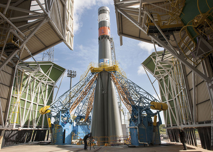
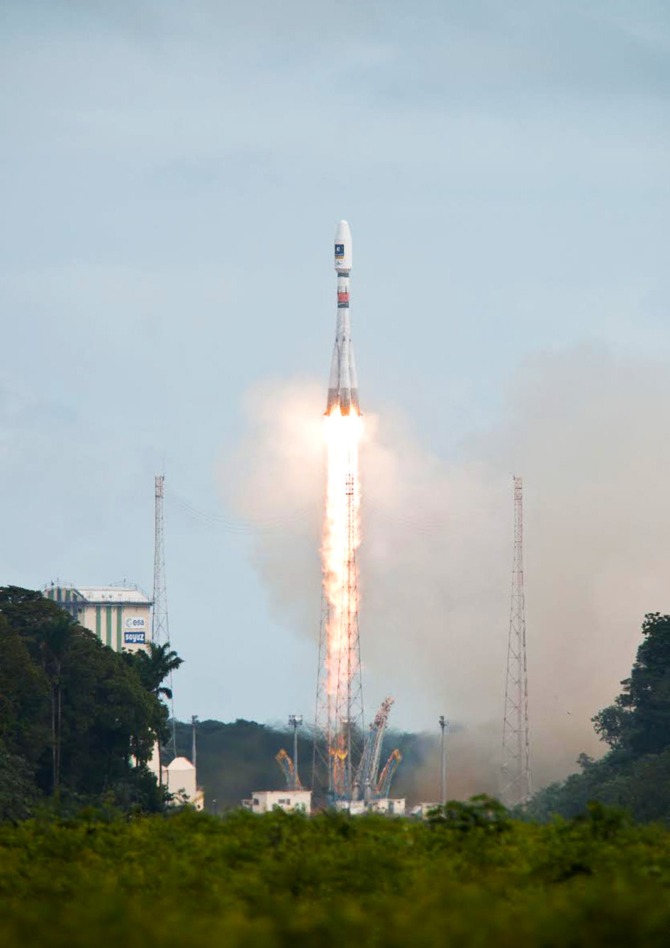
    Following the major anomaly that occurred on August 22 during the Soyuz ST mission carrying two satellites in the Galileo constellation, Arianespace announced today, in conjunction with the European Space Agency (ESA) and the European Commission, the appointment of an independent inquiry commission.

    The commission is chaired by Peter Dubock, former ESA Inspector General. Its mandate is to establish the circumstances of the anomaly, to identify the root causes and associated aggravating factors, and make recommendations to correct the identified defect and to allow for a safe return to flight for all Soyuz launches from the Guiana Space Center (CSG).

    The commission will start its work on August 28 and submit its initial conclusions as early as September 8.

    The inquiry commission comprises the following members:

    • Peter Dubock, former ESA Inspector General, Chairman;
    • Professor Guido Colasurdo, University of Roma “Sapienza”, full professor of flight mechanics;
    • Michel Courtois, former ESA Technical Director;
    • Paul Flament, European Commission, Head of Unit, Galileo and Egnos Programmes Management, DG for Entreprise and Industry;
    • Giuliano Gatti, ESA, Galileo Program Technical Officer;
    • Professor Wolfgang Kubbat, former head of the Institute of Flight Systems and Automatic Control at the Technical University of Darmstadt;
    • Isabelle Rongier, CNES Inspector General;
    • Toni Tolker Nielsen, ESA Deputy Inspector General.

    To maintain links with the Russian partners in the Soyuz at CSG program, the head of the Russian space agency Roscosmos, on request from the head of Arianespace, has designated Alexander Daniliuk, Deputy Director General of TsNIImash, as board liaison.

    Arianespace Chairman and CEO Stéphane Israël said: “I would like to thank Peter Dubock for having accepted the chairmanship of this commission, which was appointed in conjunction with ESA and the European Commission and with the support of the space agencies from France (CNES), Germany (DLR) and Italy (ASI), along with a team of high-level European experts. The commission will now be able to carry out its work independently, operating under a very tight schedule. We sincerely hope that the commission’s recommendations will lead to a rapid resumption of missions, while ensuring the high reliability expected of our Soyuz launches from CSG.”

  • Galileo Satellites Not in Expected Orbit

    Galileo Satellites Not in Expected Orbit

    After the separation of the two Galileo satellites launched August 22, ongoing analysis of the data provided by the telemetry stations operated by the European Space Agency (ESA) and the French space agency CNES showed that the satellites were not in the expected orbit.
    According to the initial analyses, an anomaly is thought to have occurred during the flight phase involving the Fregat upper stage, causing the satellites to be injected into a noncompliant orbit.


    UPDATE: Inquiry Commission Appointed Following Galileo Anomaly


    The liftoff and first part of the mission proceeded nominally, reports Arianespace, leading to release of the satellites according to the planned timetable, and reception of signals from the satellites. However, the targeted orbit was circular, inclined at 55 degrees with a semi major axis of 29,900 kilometers. The satellites are now in an elliptical orbit, with excentricity of 0.23, a semi major axis of 26,200 km and inclined at 49.8 degrees.

    Both the Fregat upper stage and the two satellites are in a stable condition and position that entails no risk for people on the ground. The residual propellants on the Fregat stage have been purged and the stage was depressurized normally.

    Studies and data analyses are continuing in Kourou, French Guiana, and at Arianespace headquarters in Evry, near Paris, under the direction of Stéphane Israël, Chairman and CEO of Arianespace, in conjunction with the Russian partners in the Soyuz in French Guiana program (Russian space agency Roscomos and the manufacturers RKTs-Progress and NPO Lavotchkine), as well as Arianespace’s customer ESA and its industrial partners, to determine the scope of the anomaly and its impact on the mission.

    Following the announcement made by Arianespace on the anomalies of the orbit injection of the Galileo satellites, ESA said that the teams of industries and agencies involved in the early operations of the satellites are investigating the potential implications on the mission.

    Both satellites have been acquired and are safely controlled and operated from ESOC, ESA’s Operations Centre in Darmstadt, Germany. Further information on the status of the satellites will be made available after the preliminary analysis of the situation.

    “Our aim is of course to fully understand this anomaly,” said Stéphane Israël, Chairman and CEO of Arianespace. “Everybody at Arianespace is totally focused on meeting this objective. Starting Monday, Arianespace, in association with ESA and the European Commission, will designate an independent inquiry board to determine the exact causes of this anomaly and to draw conclusions and develop corrective actions that will allow us to resume launches of Soyuz from the Guiana Space Center (CSG) in complete safety and as quickly as possible. The board will coordinate its work with Russian partners in the Soyuz at CSG program. Arianespace is determined to help meet the European Union’s goals for the Galileo program without undue delay. We would like to thank ESA, the European Commission and CNES for the very productive discussions since becoming aware of the occurrence of the anomaly. While it is too early to determine the exact causes, we would like to offer our sincere excuses to ESA and the European Commission for this orbital injection that did not meet expectations.”

    New NORAD element sets from Sunday confirm that the satellites and the Fregat upper stage are in the wrong orbits:

    TBA – TO BE ASSIGNED

    1 40128U 14050A   14235.29903612 -.00000029  00000-0  00000+0 0    62

    2 40128 049.6865 087.6132 2327926 024.5112 345.1155 02.04736595    14

    TBA – TO BE ASSIGNED

    1 40129U 14050B   14235.68621972 -.00000026  00000-0  00000+0 0    36

    2 40129 049.6897 087.5935 2330669 024.6823 271.0168 02.04928670    16

    TBA – TO BE ASSIGNED

    1 40130U 14050C   14235.29836211 -.00000029  00000-0  00000+0 0    43

    2 40130 049.7055 087.6017 2323101 024.6200 345.0221 02.05021368    10

  • NovAtel Introduces New IMU to SPAN Line of GNSS Products

    NovAtel Introduces New IMU to SPAN Line of GNSS Products

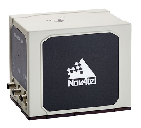
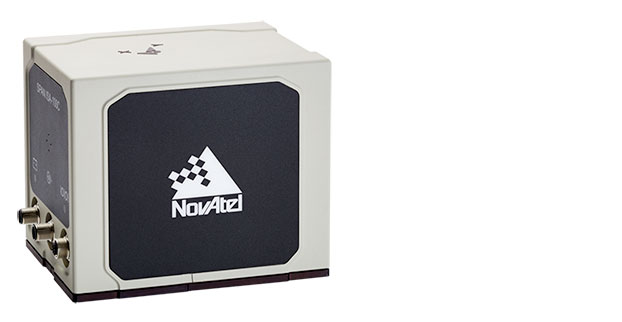
    NovAtel IMU-ISA-100C.
    NovAtel IMU-ISA-100C.

    NovAtel Inc. has added the IMU-ISA-100C as an inertial measurement unit (IMU) option to its SPAN GNSS+INS line of positioning products. The IMU-ISA-100C is a high-performance, near navigation-grade IMU designed for platform stabilization, general-purpose navigation, photogrammetry, remote sensing, and ground mobile-mapping applications.

    Commercially exportable, the IMU-ISA-100C integrates easily with a NovAtel SPAN capable receiver to provide a tightly coupled 3D navigation solution, NovAtel said. Offering customers continuous position, velocity and attitude (roll, pitch and azimuth) measurements, a SPAN system is stable and available even through periods when satellite signals are blocked or unavailable.

    With the IMU-ISA-100C, customers will receive near navigation-grade performance, at an affordable price point.  The product also features a new enclosure designed to maximize versatility for a range of applications.

    “The compelling aspect of this product is its value — it is a high-end SPAN solution, delivering extremely precise positioning, at an attainable price point,” said Siamak Akhlaghi, NovAtel’s product manager, SPAN. “And without the export constraints, it can be shipped internationally in a timely fashion.”

  • Arianespace, ESA Sign Contract for New Galileo Launches

    Arianespace, ESA Sign Contract for New Galileo Launches

    Arianespace and the European Space Agency (ESA), acting on behalf of the European Commission, have signed a contract for three launch services with Ariane 5 ES to step up deployment of Galileo satellites.

    With this new launch contract and thanks to the performance of Ariane 5 ES, a total of 12 Galileo FOC (Full Operational Capability) satellites will be launched using three dedicated Ariane 5 ES launch vehicles, each carrying four satellites. The Ariane 5 ES launches will take place from 2015 onwards.

    Arianespace will be responsible for ensuring all of the 22 FOC satellites manufactured by the German group OHB System alongside the British company Surrey Satellite Technology Ltd. are taken into circular orbit at an altitude of 23,522 km using a combination of five Soyuz launch vehicles (two satellites per launch) and three Ariane 5 ES launch vehicles (four satellites per launch). The 22 operational satellites will join the four IOV satellites launched successfully by Arianespace from the Guiana Space Center in 2011 and 2012.

    Arianespace and its subsidiary Starsem were responsible for launching in 2005 and 2008 from the Baikonur Cosmodrome the initial satellites in the Galileo constellation, GIOVE-A and GIOVE-B, which were able to secure the frequencies allocated to the constellation.

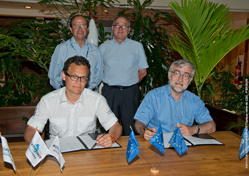
    The contract for Arianespace’s three Ariane 5 launches to orbit a total of 12 Galileo FOC satellites was signed at the Guiana Space Center by Chairman and CEO Stéphane Israël (seated, at left) and Didier Faivre, ESA director of the Galileo Program and Navigation-related Activities. Joining them were ESA Director General Jean-Jacques Dordain and Daniel Calleja Crespo, director general for Enterprise and Industry, European Commission.
    The contract for Arianespace’s three Ariane 5 launches to orbit a total of 12 Galileo FOC satellites was signed at the Guiana Space Center by Chairman and CEO Stéphane Israël (seated, at left) and Didier Faivre, ESA director of the Galileo Program and Navigation-related Activities. Joining them were ESA Director General Jean-Jacques Dordain and Daniel Calleja Crespo, director general for Enterprise and Industry, European Commission.

    Once the contract had been signed, Stéphane Israël, chairman and CEO of Arianespace, made the following statement: “With its Ariane 5 ES heavy-lift launch-vehicle, Arianespace is able to provide the most appropriate solution for stepping up the deployment of the entire Galileo constellation. Ariane has once again demonstrated its excellence as it lends its expertise to Europe’s ambitions in space. With the three Ariane, Vega and Soyuz launch-vehicles operated from the Guiana Space Center, European spaceport, Arianespace is giving Europe guaranteed access to space and suitable solutions to meet its wide-ranging needs. I would like to extend my heartfelt thanks to the European Commission and European Space Agency (ESA) for their continued trust. Being the launch operator of the Galileo program is an immense source of pride for Arianespace, its employees and its partners.”

  • Royal Institute Hosts New Navigation Conference

    Royal Institute Hosts New Navigation Conference

    INC_2015_logoThe Royal Institute of Navigation is launching a new international conference series, tackling some of the biggest issues across the domains of modern navigation: land, sea, air and space.

    The RIN is now accepting abstracts for the conference.

    The International Navigation Conference 2015, set for February 24-26, 2-15, is planned as a first event in a new series of world-class conferences. The first conference will highlight the state of the art in fields such as GNSS and Galileo, indoor positioning, autonomous transport, security and resilience of navigation in the world of cyber attacks, and new quantum technologies. The event will be of special interest to the maritime, aviation, PNT, transport, research and development and security communities.

    Speakers, and the topics they will discuss, include:

    • Privacy In Tracking (smartphones and indoor navigation) – Google
    • Security and resilience — Dana Goward, president and executive director, U.S .Resilient Navigation and Timing Foundation
    • Multi-Constellation GNSS — Gian Gherado Calini, GSA
    • Multi-Sensor Integration — Professor Dorota Grejner-Brzezinska, The Ohio State University
    • Quantum Technologies — Sir Peter Knight, professor of Quantum Optics and Senior Research Investigator, Imperial College London
    • Emerging Trends and Current Challenges — Colin Beatty FRIN, CBiL
    • Autonomy in transport — BAE, ASTREA
    • Legal Aspects of Navigation — Professor Frans von der Dunk, Institute of Space Law, Leiden University

    To learn more, visit the conference website.

  • Topcon Releases Next-Generation 3D Laser Scanners

    Topcon Releases Next-Generation 3D Laser Scanners

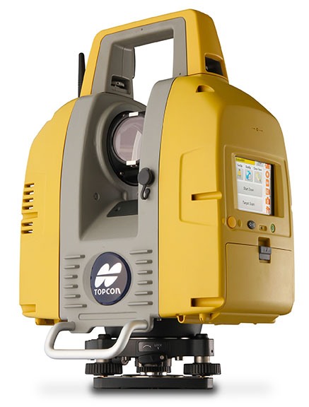
    GLS-2000 laser scanner by Topcon.
    GLS-2000 laser scanner by Topcon.

    Topcon Positioning Group announces the release of the newest edition to the GLS line of laser scanners, ­ the GLS-2000. Featuring an expanded field of view, the GLS-2000 is designed to pair with ScanMaster v3.0 software for quickly capturing and processing 3D point-cloud data.

    “The GLS-2000 is the fastest and most versatile scanning system in its class,” said Charles Rihner, vice president for the Topcon GeoPositioning Solutions Group. “With a scan range of more than 350 meters, the GLS-2000 is capable of accurately capturing long-distance measurements in applications where access is limited due to safety or logistics concerns.”

    Using Topcon Precise Scan Technology II, the GLS-2000 is designed to emit pulse signals three times faster than earlier models. “Using faster pulse signals enables timing to be detected more precisely, which results in reduced noise and higher-accuracy data,” said Rihner.

    “With the on-board control software, scanning can simply be started with the touch of a button. Even entry-level users can intuitively operate the GLS-2000 that comes complete with a color graphical display,” said Rihner.

    Additional features include a full-dome scanning range, user selectable Class 3R or 1M laser, and an exclusive laser plummet function that measures instrument height with a one-touch operation.