Blog

  • GPS III and OCX Satellite Launch, Early Orbit Ops Successfully Demonstrated

    GPS III and OCX Satellite Launch, Early Orbit Ops Successfully Demonstrated

    Artist's concept of the nextgen GPS III satellite (courtesy of the USAF).
    Artist’s concept of the nextgen GPS III satellite (courtesy of the USAF).

    Lockheed Martin and Raytheon Company successfully completed the third of five planned launch and early orbit exercises to demonstrate the launch readiness of the world’s most powerful and accurate Global Positioning System (GPS), the U.S. Air Force’s next-generation GPS III satellite and Operational Control System (OCX).

    Successful completion of Exercise 3, on August 1, was a key milestone demonstrating Raytheon’s OCX software meets mission requirements and is on track to support the launch of the first GPS III satellite, being produced by Lockheed Martin. Two additional readiness exercises and six 24/7 launch rehearsals are planned before launch of the first GPS III satellite in 2015.

    Using new installments of Raytheon’s OCX software and Lockheed Martin’s GPS III Launch and Checkout Capability (LCC), the Air Force Global Positioning System Directorate and the industry team completed a launch and early orbit exercise over a three-day period in late July. Exercise 3 demonstrated space-ground communications; first acquisition and transfer orbit sequences; orbit-raising maneuver planning and execution; and basic anomaly detection and resolution capabilities. In addition, the industry and customer teams jointly executed mission planning activities, such as orbit determination and the generation of upload command files.

    Exercise 3 expands on two previous exercises, with a longer mission timeline, and the introduction of simulated vehicle and ground anomalies to evaluate the combined response capabilities of the control segment, satellite and operations crew. “Successful completion of Exercise 3 clearly demonstrates that OCX is on track to support the first GPS III satellite launch,” stated Matt Gilligan, a vice president with Raytheon’s Intelligence, Information and Services business and Raytheon’s GPS OCX program manager. “The system responded as designed, and met all of the launch exercise success criteria and successfully demonstrated our anomaly response.”

    “Exercise 3 demonstrated that the cross-organizational operations team is on track to support successful GPS III launch and on-orbit checkout missions from our Newtown facility,” said Keoki Jackson, vice president of Lockheed Martin’s Navigation Systems mission area. “I look forward to the team’s continued success as they progress through the complex mission readiness program towards the first GPS III launch.”

    The Lockheed Martin-developed GPS III satellites and Raytheon‘s OCX are critical elements of the U.S. Air Force’s effort to modernize the GPS enterprise more affordably while improving capabilities to meet the evolving demands of military, commercial and civilian users worldwide.

    GPS III satellites will deliver three times better accuracy; provide up to eight times more powerful anti-jamming capabilities; and include enhancements which extend spacecraft life 25 percent further than the prior GPS block. The GPS III also will carry a new civil signal designed to be interoperable with other international global navigation satellite systems, enhancing civilian user connectivity.  The spacecraft bus and antenna assemblies for the first GPS III satellite have been delivered to Lockheed Martin’s GPS III Processing Facility and are in the integration and test flow leading to the planned space vehicle delivery in mid-2014.

    OCX is being developed in two Blocks using a commercial best practice iterative software development process, with seven iterations in Block 1 and one iteration in Block 2. Exercise 3 was conducted using the recently completed Iteration 1.4 software. Exercise 4, scheduled for early 2014, will use Iteration 1.5 software, which includes the Launch and Checkout System capability as well as all critical information assurance features needed to support launch of the first GPS III satellite.

    The GPS III team is led by the Global Positioning Systems Directorate at the U.S. Air Force Space and Missile Systems Center. Air Force Space Command’s 2nd Space Operations Squadron (2SOPS), based at Schriever Air Force Base, Colorado, manages and operates the GPS constellation for both civil and military users.
  • Dedicated GPS Devices to Reach $7 Billion in 2018

    Despite the continued decline of PNDs, and the threat of smartphones, smart watches and eyewear, the portable GPS-enabled device market is forecast to continue to hold its own thanks to dedicated HUD/eyewear, cycling and health/tracking devices, according to a report by ABI Research.

    ABI Research’s quarterly GNSS Database forecasts the new and emerging markets for GPS-enabled devices, and where the opportunities lie in terms of device formats and vertical markets. The report also considers the impact of competitive formats such as smartphone applications, wearable sensors, smart watches, and smart eyewear, providing a complete picture of drivers and inhibitors in this market.

    Senior analyst Patrick Connolly comments, “The overall market is forecast to grow from 33.3 million units in 2012 to 36.79 million in 2018, following a brief dip in 2013 as PND declines outweigh growth in other areas. Total revenues will undergo a brief period of fluctuation from 2013 to 2015, before rising to $7.14 billion in 2018.”

    Dominique Bonte adds, “The markets for cycling computers, health/elderly, and fitness are starting to get interesting. As ASPs decline and smart watches become a more established part of our lives, the addressable market will be eaten up, limiting the growth potential for dedicated fitness devices. Looking longer term, ABI Research has forecast very strong growth for HUD/eyewear devices, particularly in the fitness, golf, and cycling categories. It would not be surprising to see an acquisition in this space over the next 12 months.”

    These findings are part of ABI Research’s Location Devices Research Service, which includes research analyses, market data, insights, and competitive assessments focused on the GPS/GNSS IC and devices markets.

  • Astrium to Provide Satellite Imagery for Google Maps and Google Earth

    Astrium announced that it has entered into an agreement with Google Inc. to provide satellite imagery in support of Google Maps, Google Earth and other Google products and services. Under this agreement, Astrium Services will provide newly acquired imagery from its Pléiades and SPOT satellites.

    According to the announcement, Pléiades 1A and 1B are Europe’s first very high-resolution Earth-observation satellites, offering exceptional performance to support both commercial and government markets with 50cm resolution imagery products. The SPOT 6 and SPOT 7 constellation, operated in conjunction with Pléiades, offers 1.5m resolution imagery products and is uniquely capable of mapping continent-wide areas.

    Astrium reports that their four-satellite constellation makes Astrium Services the first satellite operator in the world to offer a complete range of Earth-observation data at different resolutions (from medium to very high-resolution), an image collection capacity of up to 6.5 million square kilometers each day and the ability to image every point of the globe on a daily basis.

  • Registration Opens for Munich Satellite Navigation Summit 2014

    Registration is now open for Munich Satellite Navigation Summit 2014, which will be held March 25-27, 2014, at the Residenz Muenchen in Munich, Germany.

    The summit will have a booth (Booth H) in the exhibit hall at the ION GNSS+ conference next week in Nashville, Tennessee. The conference is offering a special ION rate for those who register no later than October 21.

    The summit has been established as the European and International conference with global impact featuring invited high-ranking worldwide speakers from industry, science and governments dealing with the directions of satellite navigation now and in the future.

    The summit starts on March 25 with the Exhibition Opening and Champagne Reception at 16.30 hrs. The technical programme of the conference starts with the Opening Plenary Panel discussing the topic “GNSS – New Challenges” at 17.15 hrs. Afterward, the Bavarian State Reception in the famous Residenz München provides opportunities for networking.

    The technical program includes plenary discussions among invited speakers and presents a concise update on the main activities in worldwide satellite navigation systems, in particular:

    • Implementation of the European satellite navigation system Galileo
    • Modernization of the U.S. Global Positioning System (GPS IIF, GPS III)
    • Status and modernization of the Russian Global Satellite Navigation System GLONASS
    • Developments of new global and regional systems like the Chinese COMPASS, the Japanese QZSS and the Indian IRNSS
    • Space-Based Augmentation systems (SBAS)
    • Legal issues of privacy devices and GNSS re-transmitters
    • Getting the centimeter on global scale (Precise Point Positioning)
    • Design of future navigation systems: Will autonomous sensors come to the fore
    • GNSS monitoring of the system earth and natural disasters
    • Integrated applications of GNSS and Earth Observation

    The Munich Satellite Navigation Summit will further highlight the creation of new applications and services in satellite navigation, in combination with telecommunication and information technology, in particular geo-information technology.

    Various sessions will feature discussions among invited panellists talking about perspectives and critical issues in various rapidly growing application scenes of satellite navigation, in particular with Galileo. Brief presentations and statements of the panelists are initiating each session. An interactive question and answer period with the auditorium is closing the topic.

    In 2014:

    • An exhibition for industry and institutions is taking place during the conference.
    • The European Satellite Navigation Master competition will be announced.
    • The summit includes a parallel track on Copernicus the European Commission’s Earth Observation Programme. Alongside technical and political updates, the sessions will also give insight into services and applications enabled by the programme.

    The Summit is part of the efforts of the Bavarian government and the cluster on aerospace and satellite navigation to stimulate applications and services in this high-tech field.

    For more information, contact +49-89-6004-3425 or e-mail [email protected].

  • Loctronix Offers Software-Defined Radio Module

    Loctronix Offers Software-Defined Radio Module

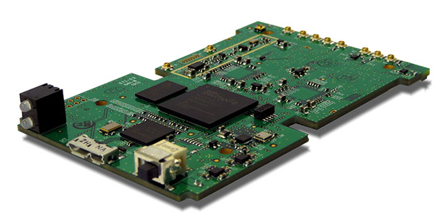
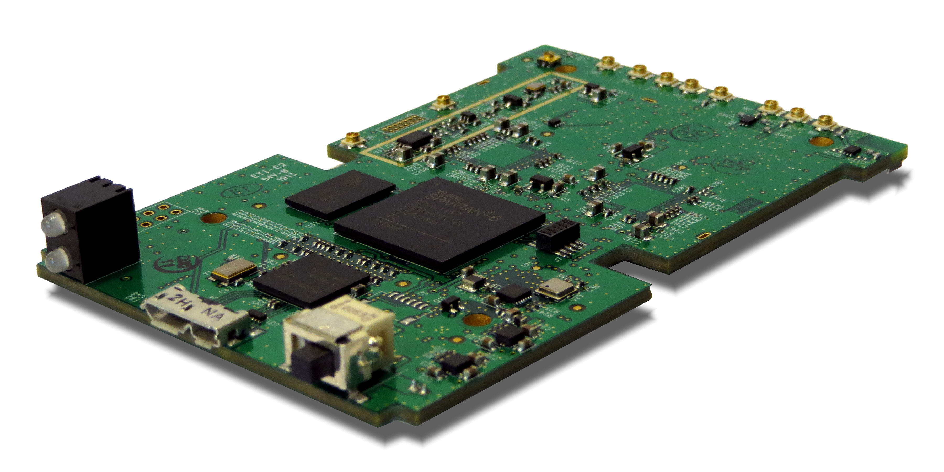
    Loctronix ASR-2300
    Loctronix ASR-2300

    Loctronix Corporation, a provider of unified positioning solutions for GNSS-challenged environments, is making available its new software-defined radio (SDR) module, the ASR-2300, for developing high-performance positioning, navigation and timing, and communication applications.

    The ASR-2300 will be on display September 16-19 at the Institute of Navigation annual meeting, ION GNSS+ 2013, in Nashville, Tennessee.

    “The ASR-2300 delivers advanced SDR capabilities in a small, mobile form-factor enabling developers to readily create and field complex SDR-based solutions. The module moves SDR out of the lab and into production, providing the critical piece for tapping advanced, multi-sensor/signals of opportunity for high-performance PNT,” stated Michael Mathews, Loctronix’ CEO and founder.

    According to Mathews, “The ASR-2300 is unique amongst the growing number of SDRs, having multiple, fully-integrated RF paths supporting reception of GNSS, cellular, ISM band, and UHF signals of opportunity. The ASR-2300 will benefit SDR developers working on demanding scientific, military, aerospace and commercial/industrial applications.”

    The ASR-2300 is a multiple-input and multiple-output (MIMO) transceiver module incorporating two wideband Field Programmable RF (FPRF) transceivers (300 MHz to 3.8 GHz) from Lime Microsystems, 10-axis accelerometer/gyro/compass/barometer sensors, and a large programmable FPGA capable of over 300 MiB/sec sustained communications with a host processor via USB 3.0 interface.  The module’s nine integrated RF path options and low size, weight, and power characteristics contribute to ease of integration and portability. Accommodating both internal 1 PPM TCXO or external frequency reference, multiple ASR-2300s can be inter-connected via an expansion port and/or UART interface, supporting real-time reception / transmission of 4, 6, 8 or more signals without the need for significant additional hardware.

    With on-board flash for storing developer customizable firmware and FPGA logic, the ASR-2300 can be configured to operate in a variety of different power profiles, maximizing battery life without requiring a host processor.  The modules will be factory-programmed with only the RF receiver capabilities enabled.  Developers can enable transmit functionality by modifying the firmware and waveforms.

    The A2300 Open Source Project at Myriad RF

    To encourage innovation in PNT and communications applications, Loctronix has partnered with Lime Microsystems to provide the source materials for the ASR-2300 module under open source licensing at the Myriad RF project.

    “The broad utility of the ASR-2300 makes it an ideal platform for prototyping and developing advanced applications in the communications and PNT markets. Developers can make their own boards using the documents and design database contained in the A2300 project and/or purchase hardware, development kits, support services, and licensed waveforms directly from Loctronix,” Mathews said.

    “Encouraging collaboration between the open source community and industry is a natural way to promote innovation and accelerate growth of SDR technology. We are delighted to partner with Loctronix to make their innovative ASR-2300 SDR design available to open source developers for creating advanced SDR applications,” said Lime Microsystems CEO Ebrahim Bushehri, Ph.D.

    The open-source software package includes basic drivers for Linux and Windows environments enabling both GNU Radio and embedded C/C++ developers to interface with the ASR-2300 module.  Developers can obtain source code and design documents for modifying the ASR-2300 to suit their own applications.

    The ASR-2300 will be available from Loctronix this November. Adaptors, antennas, and a housing kit will also be available that provide a variety of configuration options supporting bench-top testing to wearable, battery-operated field demonstrations.

  • AirPatrol Quantum Leaps Into Location-Based Services

    Moving to stake a claim in the burgeoning location-based services and applications market, mobile systems developer AirPatrol Corporation has announced a pair of new offerings designed to let organizations and 3rd software developers enable app and information delivery to mobile devices in zones as small as six feet across.

    The first product, ZoneAware, is a locationing and delivery platform made up of passive sensors and a software-based locationing engine that gives organizations the ability to identify both 802.11 Wi-Fi and 2G/3G/4G cellular devices and enable different applications, information delivery, and mobile services as the device moves through monitored zones within a facility. AirPatrol’s other new offering is third-party access to its AirPatrol Zone Engine, which will allow software developers to leverage AirPatrol’s device locationing technologies to enable mobile apps and information delivery based on zones up to 30 times more precise than other locationing tools.

    “We’re heading into a post-PC world where smartphones, tablets and wearable computing will be changing their behavior and the information they provide based on where the user is and what she is doing at the time,” said Cleve Adams, CEO of AirPatrol. “Most locationing technologies can provide a general area of where a device is — within 100 to 1,000 feet — which is fine for generalized activities like finding restaurants within a mile of you, but it’s not particularly useful when you want real precision. AirPatrol’s Zone technologies can notify the maître d’ to prepare a table when a VIP steps into the restaurant, tell an emergency responder exactly what floor and room an E911 caller is in, even securely deliver patient records to a doctor’s tablet when he enters the patient’s hospital room.”

    Key to AirPatrol’s Zone technologies are a combination of passive sensors that detect and identify radio signals emanating from devices on both cellular and WiFi networks, and a software platform that does the heavy work of measuring those signals and adjusting for obstructions like wood, metal, stone and glass, to deliver pinpoint locationing and the triggers to apps and information based on the zone through which the device is traveling.

    “The ability to provide precision locationing in all building types using cellular/Wi-Fi detection and not just WiFi is a major benefit of AirPatrol’s technology,” Adams said. “Wi-Fi coverage is notoriously difficult in indoor locations with lots of obstructions such as walls. Many people are also simply turning mobile’s Wi-Fi off to reduce security risks and, increasingly, because 4G cellular is faster and more reliable. Because we use both, AirPatrol’s Zone technology can provide far more consistent and accurate locationing no matter whether the device is moving or stationary, indoors or outdoors. In short, we’re detecting the other half of the cellular users no other Wi-Fi-only solution can see,” he said.

    AirPatrol’s locationing technologies were originally developed for government and military security applications where precision locationing and forensic tracking of all mobile devices was a requirement. In 2012, the company released an enterprise version of its ZoneDefense mobile security platform which augmented the device monitoring features with the ability to connect to and trigger 3rd party mobile device and application management tools (MDM/MAM), policy managers, network and endpoint security tools based on location. It was the 3rd party connectors that spawned AirPatrol’s new offerings.

    “The moment companies realized we could add a location-based component to all of the mobile apps and tools they were using we started getting inquiries about connecting healthcare applications, retail services, marketing tools, and a whole list of other non-security-related systems to our ZoneDefense platform,” Adams said. “Given how much people use and depend on their mobile devices for work, home and entertainment these days, it only made sense to open the platform up to other applications and developers.”

    AirPatrol’s ZoneAware platform will be available in early Q4 of 2013. Application developers, information providers and other third parties who would like to connect their products to the AirPatrol Zone Engine can apply to join the AirPatrol developer partners program via the AirPatrol website.

  • Lockheed Martin’s Paveway II with GPS/INS Successfully Employed In Navy Exercises

    Lockheed Martin’s paveway II Dual Mode Laser Guided Bomb (DMLGB) was successfully employed in recent U.S. Navy Tactics Development exercises at the Naval Strike and Air Warfare Center in Fallon, Nevada.

    During four missions over a two-day period, F/A-18C/D Hornets and F/A-18E/F Super Hornets released 36 GBU-12F/B bombs fitted with recently upgraded paveway II DMLGB guidance kits. The weapons were used in tactically representative engagements against fixed targets and met all mission success criteria, demonstrating the increased operational utility of the enhancements.

    By adding the GPS/Inertial Navigation System (INS) guidance to standard laser-guided paveway II weapons, the U.S. Navy and Marine Corps can execute precision-strike missions against stationary and relocatable targets in all weather conditions. The kits can operate in laser mode only, INS/GPS mode only or dual mode to provide pilots with the flexibility to engage various types of targets in a single mission. The most recent paveway II DMLGB upgrade to Block II Operational Flight Program software improves overall weapon performance and effectiveness in all three release modes.

    “We worked closely with our U.S. Navy and Marine Corps customers to develop the Block II Operational Flight Program software upgrade to the paveway II DMLGB guidance kits,” said Joe Serra, precision guided systems manager at Lockheed Martin Missiles and Fire Control. “Delivered to the fleet earlier this year, the enhanced fire-and-forget technology of our DMLGB kits provides naval warfighters with a mature and highly maneuverable all-weather direct-attack capability.”

    Aircrews from the Naval Strike and Air Warfare Center, along with Air Test and Evaluation Squadron Nine (VX-9) “Vampires” from Naval Air Weapons Station in China Lake, California, participated in the exercises.

    “The same company-wide discipline that provides customers with affordable single-mode LGB targeting capability is applied to our current and future dual-mode weapons to provide U.S. and international customers with the most affordable and reliable precision capability,” said Serra.

    Lockheed Martin has upgraded more than 7,000 paveway II LGB guidance kits with dual-mode, all-weather capability for the U.S. Navy. Additionally, the company has delivered more than 65,000 LGB kits and over 125,000 Enhanced Laser Guided Training Rounds to the U.S. Navy, Marine Corps, Air Force and international customers. Lockheed Martin is the sole-source developer and provider of the paveway II DMLGB kits to the U.S. Navy and U.S. Marine Corps.

    Lockheed Martin Missiles and Fire Control is a 2012 recipient of the U.S. Department of Commerce’s Malcolm Baldrige National Quality Award for performance excellence. The Malcolm Baldrige Award represents the highest honor that can be awarded to American companies for achievement in leadership, strategic planning, customer relations, measurement, analysis, workforce excellence, operations and business results.

    Headquartered in Bethesda, Maryland, Lockheed Martin is a global security and aerospace company that employs about 116,000 people worldwide and is principally engaged in the research, design, development, manufacture, integration and sustainment of advanced technology systems, products and services. The Corporation’s net sales for 2012 were $47.2 billion.

  • Raytheon UK Receives Order for GPS Anti-Jam Prototype

    Raytheon UK has taken its first order for a pre-production MiniGAS, the latest in GPS Anti-Jam technology, designed and manufactured by the company in the U.K. This contract, awarded by an undisclosed customer, requires Raytheon UK to produce demonstrator units for customer evaluation.

    MiniGAS is the latest in Raytheon’s GPS anti-jam family of products, and it aims to be the lightest and smallest GPS anti-jamming system produced by Raytheon UK. It will have flexible form factors, suited to land, unmanned aerial vehicles and missile platforms. Raytheon is also producing demonstration units of its Landshield high performance digital anti-jam product for customer evaluation.

    As well as developing new products, Raytheon has also received an order for a further 100 of its Advanced Digital Antenna Production (ADAP) systems with the U.S. government. To date, more than 500 ADAP systems and more than 6,600 GAS-1 systems have been delivered to the U.S. government and other international customers over the course of 15 years.

    “Raytheon UK is a world leader in the production and supply of GPS anti-jamming systems to the majority of the world’s military forces,” said Richard Daniel, defence director for Raytheon UK. “These contracts and milestones demonstrate that we continue to make advancements in new systems, ensuring that Raytheon’s systems continue to meet the latest platform requirements.”

    Raytheon continues to deliver GPS anti-jam systems to Northrop Grumman Italia to be used in the Eurofighter Typhoon aircraft, and the company has also delivered a significant number of systems for the Airbus Military A400M aircraft. The company also completed the delivery of its first order for its latest GPS Anti-Jam Land product to the UK Ministry of Defence within six months of contract award.

  • HERE Announces Partnerships with Automakers and Suppliers to Connect Cars to the Cloud

    HERE announced ahead of the Frankfurt Motor Show that it has partnered with the Mercedes-Benz division of Daimler and two of the world’s leading automotive system integrators, Continental Corporation and Magneti Marelli. These partners are building on the HERE Connected Driving framework to offer individual connected products and services that go beyond navigation to meet their differing needs.

    According to the announcement, connectivity will allow cars to compute real time information on demand so that the vehicle can take over more aspects of driving ultimately creating an entirely new class of services.

    Mercedes-Benz

    HERE announced is has teamed up with Mercedes-Benz to jointly develop smart maps for connected cars and ultimately, self-driving cars. HERE and Mercedes built a 3D digital map of the route that the first Benz Patent-Motorwagen took 125 years ago from Mannheim to Pforzheim, Germany. Based on the particular requirements of autonomous vehicles, this map includes precise road data that go beyond traditional maps, including the number and direction of lanes, traffic signs along the route and even exact coordinates of traffic lights. While autonomous vehicles may not hit the streets commercially for several years, automakers and tech innovators alike must already think about the infrastructure and technological requirements needed to support this technology.

    Magneti Marelli

    HERE announced they are working with Magneti Marelli to develop an end-to-end connected driving solution ready to use for car makers, based on Magneti Marelli’s open platform and the HERE Connected Driving offering. It takes advantage of dynamic content from the HERE Auto Cloud such as real-time traffic information, parking and fuel prices as well as information on local places.

    Continental Corporation

    Continental Corporation recently announced that it has implemented 3D content from HERE into its new Infotainment platform. With HERE, the platform will integrate different location based applications into cars such as 3D Landmarks, satellite imagery with split screen and current traffic information among other location based applications. Drivers can also synch navigation destinations and route preferences across the in-dash system in their vehicles and their smartphone, tablet, or PC.

    “We believe that the evolution towards a connected car future will happen in different phases. Autonomous driving is just one fascinating aspect,” said Michael Halbherr, Head of HERE and EVP at Nokia. “Every car OEM, system integrator and every driver will require their own unique solution and technology will never be able to replace human understanding. That is why we have created our Connected Driving solutions with fresh maps at their core.”

    The HERE Connected Driving offering will be demonstrated at the International Motor Show  starting on September 10 at Hall 4.1, Stand E30.

  • Racelogic to Launch LabSat3 at ION GNSS+

    Racelogic to Launch LabSat3 at ION GNSS+

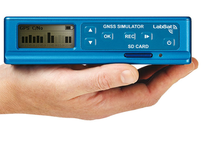
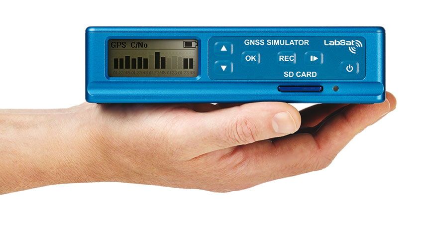
    Racelogic LabSat 3
    Racelogic LabSat 3

    LabSat, the GPS record, replay, and simulation brand produced by Racelogic in the UK, is about to be augmented with the introduction of LabSat3.

    The key feature of the new product is its simplicity. It is, essentially, a single-box device that incorporates a GPS record-and-replay system without the need for a laptop or PC. Racelogic has designed the LabSat3 with convenience at its core: it is small and light, allowing users to record GPS signals in any situation, the company said. It will also come with a pre-recorded library of worldwide scenarios to allow engineers to perform immediate bench testing.

    The new LabSat is able to record signals from GPS, GLONASS, Galileo, BeiDou, QZSS, and SBAS, with the top of the range models able to output two channels simultaneously. Both the recording and replay procedures are simple one-touch operations, with data being logged to an SD card.

    LabSat3 is compatible with scenarios generated with SatGen software for those that wish to create full simulations. Ethernet connectivity extends its potential to end-of-line testing where multiple units can be remotely controlled, with potentially large savings in production line testing times.

    LabSat3 is set to be launched at the ION GNSS+ exhibition in Nashville next week. Prices will start at $4,400. For further details, visit the LabSat website.

  • Veripos Introduces GNSS Mobile for Offshore Positioning

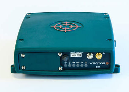
    LD7
    Veripos LD7

    Veripos, supplier of high-precision GNSS positioning services to the offshore industry, has extended its range of integrated mobile receiver units with introduction of a multi-frequency system featuring GNSS heading, L-band positioning and wireless communication capabilities, the LD7.

    Typical use is for the provision of high accuracy heading output combined with high accuracy positioning data for vessel systems.

    Compatible with both GPS and GLONASS networks, the fully ruggedized 272-channel system includes an additional processor for on-board configuration and customized applications separate from its GNSS engine. Integral wireless options include Bluetooth for simple configuration in addition to an optional full-band UHF radio modem for transmission and reception of RTCM or RTK corrections.

    With 2GB internal memory and provision for remote Ethernet access, the LD7 also features an extended range of interface facilities for data output, timing and event marks in addition to a second antenna port for GNSS heading.

  • Quantum Spatial Formed through Merger of AeroMetric, Photo Science, and WSI

    QSI_Belly_Flooded_Fields_2

    Aero-Metric, Inc. has entered into definitive agreements to acquire two providers of geospatial services and solutions — Photo Science, Inc. (Photo Science) and Watershed Sciences, Inc. (WSI) — to form Quantum Spatial. Quantum Spatial bills itself as the largest provider of location-based tools, analytics and data in North America.

    Quantum Spatial delivers professional services and solutions for clients across all industry verticals with specialized expertise in energy, transportation, utilities, environmental, mining, national security, federal agencies, state and local government, and commercial applications. Quantum Spatial plans to invest significantly to enhance its solutions, as well as expand its newly launched family of GeoApps, a suite of cloud-based, enterprise-wide, operational solutions.

    As a result of this merger, Quantum Spatial’s domestic and international clients will benefit from enhanced capabilities and solutions, the company said, as well as accelerated research and development through significant investments to create new solutions that will address the evolving challenges faced by each end market. Clients will also have complete access to the creativity and knowledge of the firms’ expanded core capabilities and resources.

    Additionally, Quantum Spatial has named Patrick Olson, the CEO of AeroMetric, the new Chief Executive Officer of Quantum Spatial. G. Michael Ritchie, president and CEO of Photo Science, will serve as the COO of Quantum Spatial. Matt Boyd and Russ Faux, former Co-CEO’s of WSI, will serve on the Executive Committee of Quantum Spatial and will lead the Solutions Applications effort across all industries.

    “I am excited to be part of the creation of Quantum Spatial and the ability to provide unmatched solutions, knowledge and scale to our clients,” said Patrick Olson. “We look forward to continuing to expand our mission of providing on-target geospatial solutions, utilizing the in-depth knowledge and expertise of the industry’s largest professional and technical staff. The added capabilities and geographic reach created by this merger will better position us to address the critical needs and priorities of our clients’ ever changing requirements across all of our markets.”

    Michael Ritchie noted, “Together, we are uniquely positioned to provide the market with the most comprehensive set of geospatial solutions available in the Americas and to greatly increase our unique tools and applications through collaboration and increased research and development. ”

    “The increased societal use of spatial data is spawning disruptive new technologies, continual innovation, and altered competitive pressure,” said Matt Boyd, Co-CEO of WSI. “These factors combine to create radical change and new opportunities. Clients want advanced analytics and answers now. Quantum Spatial will lead and accelerate this transformation.”

    Russ Faux added, ”This merger represents a strategic move that capitalizes on the collective resources, expertise, and experience of all three firms to advance the global geospatial market place. As Quantum Spatial, we are excited to expand upon our service offerings while continuing to maintain the personalized service and spirit of collaboration that our clients have come to expect and appreciate.”

    The company’s consolidation will be seamless, the company said.