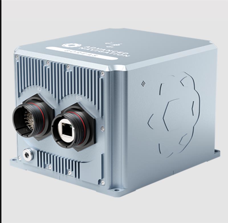
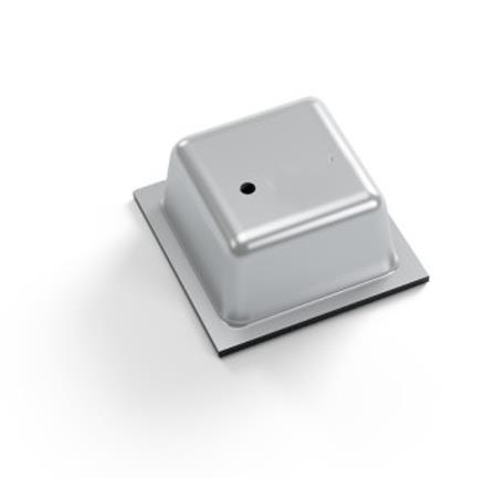
Advanced Navigation has expanded it Boreas digital fiber-optic gyroscope (DFOG) range, with the A series.
The Boreas A90 and A70 are strategic-grade inertial measurement units (IMU) that deliver acceleration and orientation with accuracy, stability and reliability under all conditions with no reliance on GNSS. They also feature automatic gyrocompassing.
The IMUs contain ultra-high accuracy DFOG and high performance closed-loop accelerometers. The Boreas A90 and A70 are both suitable for surveying, mapping and navigation across subsea, marine, land and air applications.
The Boreas A90 and A70 also offer an optional license to add INS capabilities and enable integration with external GNSS receivers using Advanced Navigation’s range of interfaces and communication protocols.
Russia released a large number of attack UAVs targeting Kyiv, Ukraine, in the early morning of June 20, reported the New York Times. The UAV attack on Kyiv was the first in several weeks after Russian forces repeatedly targeted the city throughout May.
The air-raid alert started in Kyiv around 3 a.m. local time and lasted for more than three hours, as UAVs came in waves from all directions. According to the New York Times, Ukraine’s Air Force said Russian forces had launched 35 Iranian-made UAVs around Kyiv.
Ukraine air defenses shot down 32 of the UAVs, which included more than a dozen near the capital.
On June 21, Reuters reported that Russian air defense had downed three UAVs in the Moscow region in what they believe to have been a Ukrainian attack. The Defence Ministry stated that Russian forces had used electronic jamming, which caused the UAVs to lose control and crash.
Reuters could not independently verify details of this incident or who had launched the UAV attack.
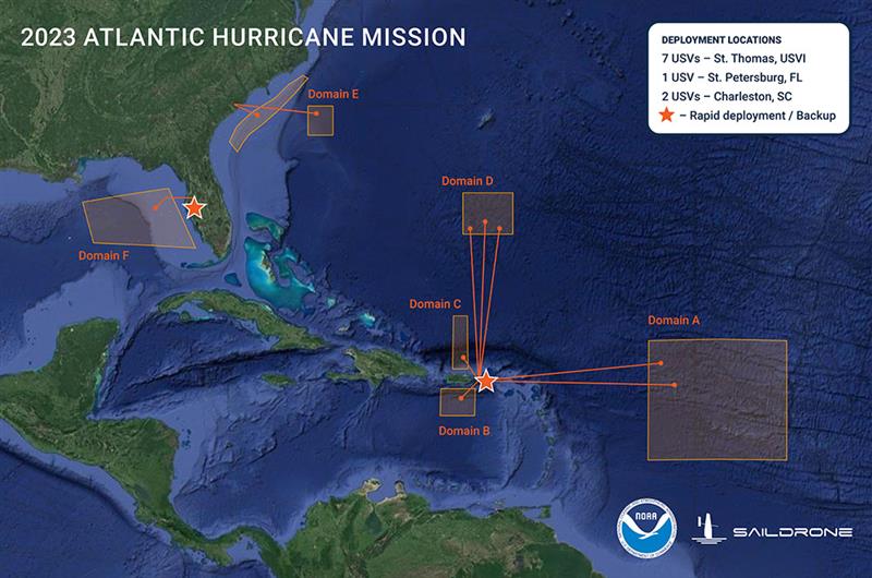
Graphic showing the USV domain areas during the 2023 Atlantic Hurricane mission. (Image: SailDrone)
Saildrone — a data solutions company for maritime security, ocean mapping, and ocean data — is deploying 12 uncrewed surface vehicles (USV) into the tropical Atlantic and Gulf of Mexico this summer, supporting the research by the National Oceanic and Atmospheric Administration (NOAA) to advance hurricane forecasting.
Saildrone is deploying 10 USVs from St. Thomas, U.S. Virgin Islands, St. Petersburg, FL, and Charleston, SC, to operate in areas with a high probability of intercepting a storm, as indicated by historical data. Two vehicles will remain on land, ready for quick deployment in the event of an approaching hurricane.
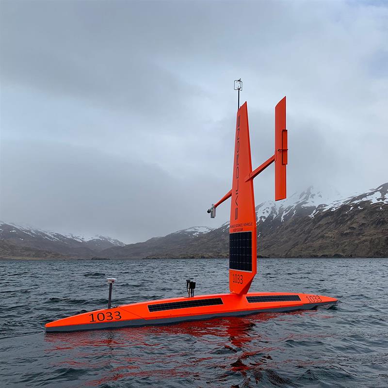
Image: SailDrone
A Saildrone Explorer is a 23-ft USV propelled by the wind and powered by solar energy. During the past two missions in 2021 and 2022, Saildrone vehicles sailed through several storms and major hurricanes, including Hurricane Sam in 2021, and Hurricane Fiona in 2022.
In addition to the Saildrone Explorers, NOAA is using a variety of aerial, surface, and sub-surface technologies, — including its Hurricane Hunter airplanes, small, uncrewed aircraft systems, gliders, drifters and floats.
The goal is to create a complete picture of the ocean-atmosphere interactions that drive hurricanes.
The USVs will transmit data, including air temperature and relative humidity, barometric pressure, wind speed and direction, water temperature and salinity, sea surface temperature, and wave height and period in near real time to scientists at NOAA’s Atlantic Oceanographic and Meteorological Laboratory and Pacific Marine Environmental Laboratory, Saildrone’s science partners for the mission.
NOAA will use the data collected by the USVs to improve hurricane forecast models. The data will also be archived by NOAA’s National Environmental Satellite, Data and Information Service and sent by NOAA to the World Meteorological Organization’s Global Telecommunication System, where it is available for the world’s major forecast centers — some 20 agencies worldwide, including NOAA.
Borderless Capital has invested in the Global Earth Observation Decentralized Network (GEODNET) Foundation via its EdgeFi Fund, the first web3 investment fund focused on decentralized physical infrastructure networks. The investment will be utilized to strengthen GEODNET’s mission with emphasis on growing reliable global coverage and a mobile operating-system software development kit.
The GEODNET Foundation manages the open network protocol and promotes service usage within the traditional GNSS and IoT industry.
With more than 3,000 reference stations online in every major continent, the real-time GEODNET network is the largest decentralized geospatial reference network. The GEODNET location service offers reliable centimeter-accurate location for applications such as UAVs, robotic vehicles, augmented reality, and IoT/mobile devices.
GEODNET station data is actively utilized by companies such as Hemisphere GNSS, Quectel Wireless Solutions and Rock Robotic. GEODNET stations owners set up a satellite mining station and are rewarded with the project’s native polygon token, GEOD.
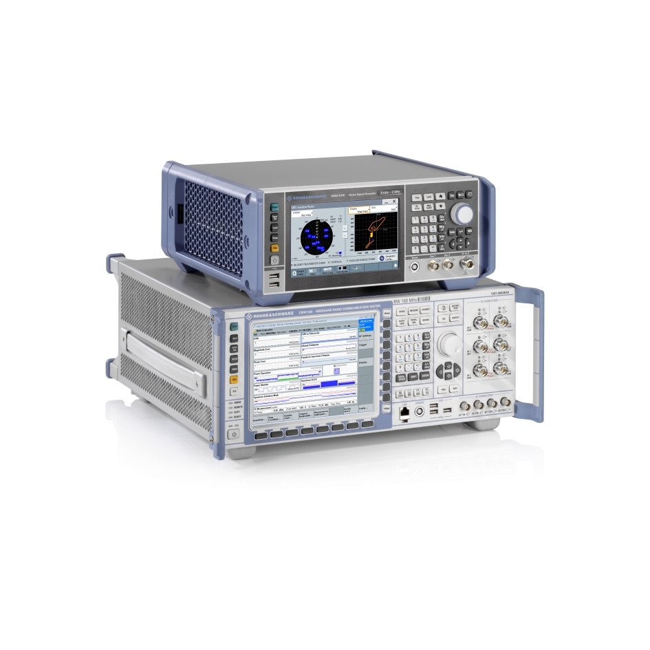
Rohde & Schwarz, in collaboration with Qualcomm Technologies, have partnered to conduct a comprehensive set of tests for narrowband-internet of things (NB-IoT) over non-terrestrial networks (NTN). This test aims to accurately verify two-way IoT data across various operating modes using geosynchronous orbit (GSO) and geostationary orbit (GEO) constellations in line with the 3GPP Release 17.
The companies will conduct a broad range of tests that address the many challenges inherent to satellite-based, non-terrestrial networks that use GSO and GEO constellations. The test set covers time and frequency synchronization from prolonged delays and the Doppler Effect, low signal-to-interference-plus-noise ratio, power saving mechanisms, satellite ephemerides, GNSS acquisition and more.
These tests will be a validation tool for Qualcomm Technologies’ NTN chips — the 212S and 9205S. The R&S CMW500 protocol testing framework scenarios and the R&S CMW 3GPP Release 17 NTN IoT protocol enabler on a single R&S CMW500 wideband radio communication tester will help engineers assess their NTN NB-IoT devices powered by Qualcomm Technologies’ NTN chips under realistic conditions.
The R&S CMW500 wideband radio communication tester emulates GSO and GEO satellite base stations in combination with the R&S SMBV100B, which generates GNSS signals. Establishing a real-time, comprehensive connection with the simulated GSO/GEO satellite network lets engineers test relevant signaling and RF scenarios in line with 3GPP Release 17.
At the MWC Shanghai 2023, Rohde & Schwarz will hold a live demonstration of the test solution at its booth with Qualcomm Technologies’ NTN Release 17 IoT chipsets.
NextNav has launched the first European commercial testbed for its high accuracy Pinnacle vertical location technology. Operating in Paris, France, the testbed will demonstrate the benefits Pinnacle can bring to local emergency response agencies and integration with applications and devices from existing NextNav partners.
Available across the United States in more than 4,400 cities and towns, and currently being deployed across Japan, Pinnacle technology provides z-axis data and has been demonstrated in independent testing to deliver 94% accuracy.
The announcement of a testbed in France comes after the release of a recent European Joint Research Centre (JRC) report, which highlighted NextNav’s accuracy in providing floor-level vertical location in addition to its ability to provide a resilient layer for traditional GPS services.
With a terrestrial-based system, NextNav aims to provide highly accurate 3D position, navigation, and timing (PNT) information — revolutionizing emergency services, logistics, telecommunications, and other sectors that rely on precise PNT and are otherwise vulnerable to GPS interference – an increasing concern across the region.
“Seen & Heard” is a monthly feature of GPS World magazine, traveling the world to capture interesting and unusual news stories involving the GNSS/PNT industry.
From paradise to panic… Or not
Tourists at the Honokohau Small Boat Harbor in Kailua-Kona, Hawaii, drove their car into the harbor after following directions on a mobile map application, and were surprised when the car filled with water, reported Insider and the Washington Post. A witness to the incident took a video showing two women in a Dodge Caravan driving “confidently” into the harbor. The witness also stated that the women were not panicked and were smiling as the car tipped forward into the water. The driver and passenger eventually climbed out of the car and were not injured in the incident. An information specialist for the Hawaii Department of Transportation stated that mobile mapping applications are inaccurate and tourists should always be aware of their surroundings.
Image: Lorado/E+/Getty Images
Apple tags to the rescue again
New York City will give out free Apple AirTags to residents in an effort to stunt an increasing number of car thefts, reported the New York Post. A local nonprofit donated 500 AirTags to the city to be handed out to residents, especially those in New York Police Department’s (NYPD) 43rd Precinct in The Bronx. NYPD encourages drivers to purchase the device if they are not able to receive one from the city. An equitable distribution plan is being designed by the Crime Prevention Unit of NYPD’s Community Affairs Bureau. The city will also be fundraising to purchase more AirTags or similar devices.
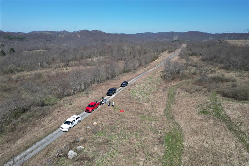
The Ottawa County Clerk’s office in West Olive, Michigan, is using location data to track vital election data around the county in real time, reported KATV News Channel 7. Once the election machine scans the results of a ballot, the data is uploaded to a flash drive and sealed with a tabulator. Then, a bipartisan group of election workers places the flash drive in a sealed container with a GPS receiver and a radio transmitter that communicates the container’s location in real time to the county clerk’s office. Ottawa County Clerk, Justin Roebuck, believes the receivers add an extra layer of security and will instill faith in voters that nobody is tampering with their ballots.
GPS plays a quiet, but integral role in Formula 1 (F1) racing. In a sport where split-second reactions are vital, GPS helps drivers and their teams improve race to race and navigate tracks safely. The importance of live location data was seen in the opening practice session at the 2023 Australian Grand Prix FP1. A red flag was flown due to loss of location data triggered by a glitch in the distribution of live tire information. This caused several near-misses on the track because drivers no longer received traffic advisory calls from their teams, reported Autosport. It took more than nine minutes to restore the real-time location data.
Southern Company — an energy provider — in partnership with Skydio, has been granted a Federal Aviation Administration (FAA) conditions-based waiver enabling remote-based, autonomous beyond visual line of sight (BVLOS) dock operations across its system.
The BVLOS waiver allows the Southern Company system to conduct remote-based infrastructure monitoring and inspection at plant sites, substations, and other fixed site locations, which enables more efficient inspections, mapping and monitoring.
The Southern Company system will conduct these BVLOS operations using Skydio X2 and Skydio Dock. Skydio’s artificial intelligence technology enables operators to safely inspect infrastructure in close proximity to structures and in complex environments.
The Southern Company system was previously granted a waiver in November 2022, that allowed for advanced BVLOS operations using UAVs to map and inspect stacks, transmission lines and basins at Plant Barry in Bucks, Alabama. This waiver granted the company the ability to conduct recurring inspections of its system’s critical infrastructure.
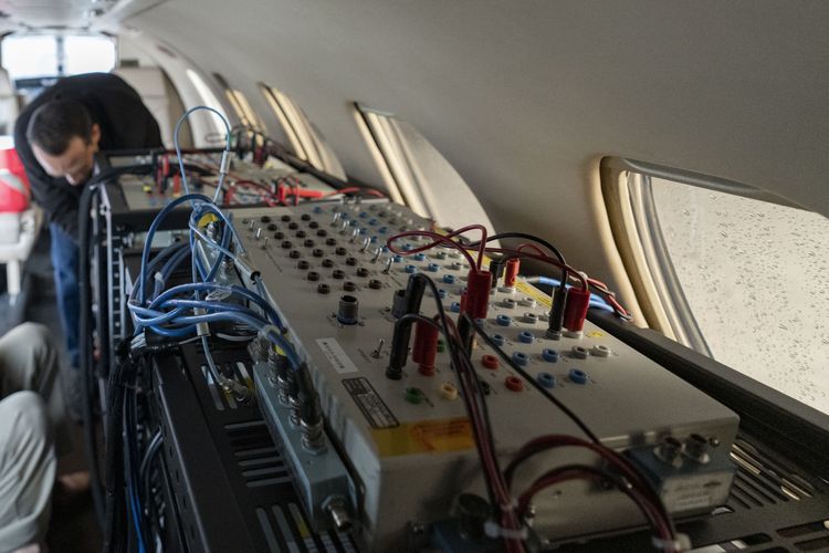
Northrop Grumman has conducted a successful flight test of its advanced airborne navigation solution, embedded GPS/INS modernization, known as EGI-M. It is the first time that EGI-M, equipped with an M-code capable receiver, has been tested in flight.
Testing took place in May aboard a testbed aircraft. Flight test data confirmed that Northrop Grumman’s prototype EGI-M solution, the M-code-capable LN-351, performed at standards equal to its current LN-251 INS/GPS system, featuring modern fiber optic gyro technology.
Critical design review for EGI-M was completed in 2020. Launch platforms for Northrop Grumman’s EGI-M include the E-2D Advanced Hawkeye and the F-22 Raptor. The fully operational EGI-M system will feature a modular platform interface, designed to integrate with current platform navigation systems — supporting advanced software and hardware technology upgrades.
Researchers at the West Virginia University Davis College of Agriculture, Natural Resources and Design are using UAVs to develop tools to detect, map, treat and monitor invasive plant species with a $175,000 grant from the Richard King Mellon Foundation.
Multiflora rose is an invasive shrub that threatens native plants in more than 40 states, including West Virginia and Pennsylvania. This project aims to equip UAVs with sensors to collect environmental data in a designated area of southwestern Pennsylvania over multiple seasons. The research team will use that data, combined with machine learning technology, to develop software that can identify multiflora rose and, eventually, other invasive species. The software could then be used for targeted delivery of herbicides via UAVs.
WVU is collaborating with two partners to help facilitate the project, including CNX — a natural gas company headquartered in Canonsburg, Pennsylvania that is offering the use of reclaimed mine land — and Resource Environmental Solutions — an ecological restoration company that is providing technical assistance with herbicide selection and deployment.
This project builds upon ongoing UAV-based research conducted by the National Resource Analysis Center (NRAC) with the U.S. Office of Surface Mine Reclamation and Enforcement. The current study focuses on autumn olive, which is one of the most common invasive brush species in West Virginia.
Most of the data collection and analysis focused on multiflora rose will begin in the 2024 spring growing season, but NRAC’s team of researchers is already using autumn olive data to see what information can be gathered about multiflora rose.
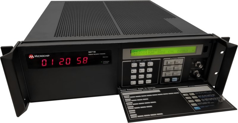
Microchip Technology has released the 5071B cesium atomic clock that can perform autonomous timekeeping for months in the event of GNSS denials.
The 5071B is the next-generation commercial cesium clock to the 5071A. The 5071B is available in a three-unit height, 19-inch rackmount enclosure, making it a compact product for environments where it can be easily transported and secured.
The 5071B has upgraded electronic components to address possible obsolescence or non-RoHS circuitry. The clock provides 100 ns holdover for more than two months, maintaining system synchronization when GNSS signals, like GPS, are denied.
As a cesium beam tube product with no deterministic long-term frequency drift, the 5071B provides absolute frequency accuracy of 5E-13 or 500 quadrillionths over all specified environmental conditions for the life of the product. For military applications requiring rapid deployments for system radars, 5E-13 stability eliminates the need for the acquisition of external synchronization sources prior to radiating.
The 5071B is now fully compliant with the Restriction of Hazardous Substances Directive, making this device available in regions where regulatory policies are in place.
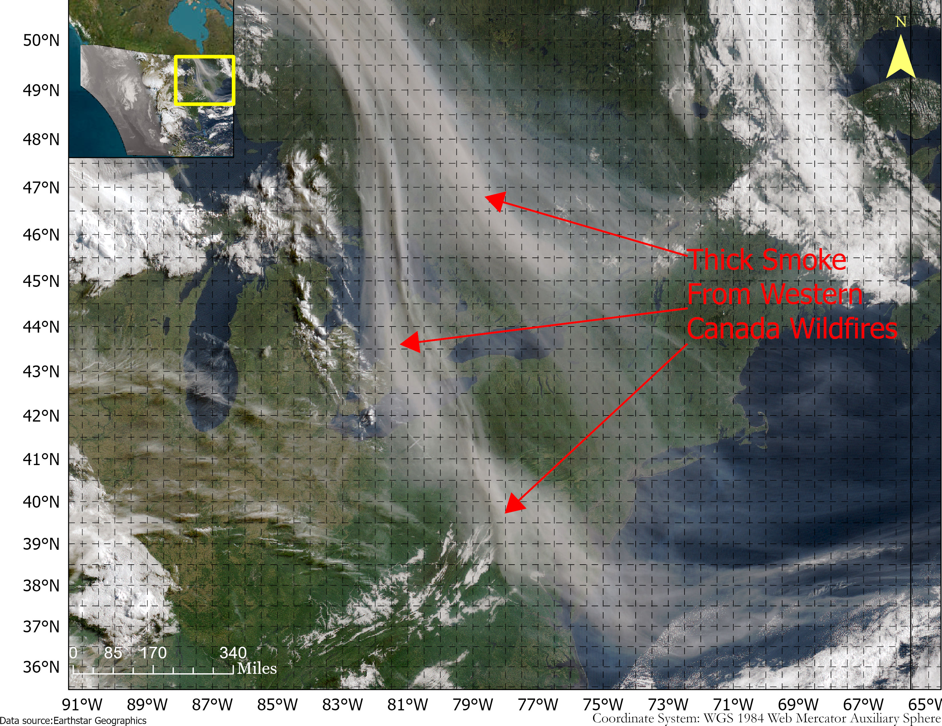
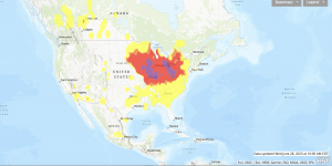
Smoke from the Canadian wildfires continues to pollute the air across the United States, mainly affecting cities in the northeast, including Pittsburgh, Chicago, Cleveland, Detroit and Buffalo.
According to the New York Times, in early June, the level of particulate matter in the air from smoke became so unhealthy that many U.S. cities set records. Visibility decreased in many cities as well, with the smoke creating an orange haze.
Most of the smoke can be attributed to several fires burning across Canada. Many of these fires were caused by lightning; however, with above-average temperatures and dry conditions, wildfires have been breaking out since May.
A storm system off the coast of Nova Scotia forced smoke from the fires southeast into the United States. (Image: NOAA)
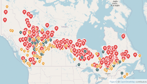
Based on data from the Canadian Interagency Forest Fire Centre, there are 480 active fires in Canada: 252 are out of control, 77 are being held in place, and 151 are under control.
The fires are mapped in the image below.
The red dots represent the out-of-control fires, the green dots are fires being held in place, and the yellow dots are fires that are under control. (Image: Screenshot of CIFFC wildfire map)
Understanding air quality importance
The Air Quality Index (AQI) measures the density of five pollutants: ground-level ozone, particulates, carbon monoxide, nitrogen dioxide, and sulfur dioxide. It was originally established by the Environmental Protection Agency to communicate the cleanliness of the air Americans are breathing every day.
The index runs from zero to 500 — the higher the number the more polluted the air is.
Effects of air pollution can range from mild symptoms, such as eye and throat irritation, to serious ones such as heart and respiratory issues. Pollution can cause inflammation of the lung tissue and increase the vulnerability to infections.
During wildfires, fine particles in the soot, ash and dust can fill the air.
The AQI identifies the concentration of particles smaller in diameter than 2.5 μM. When these particles are inhaled, the tiny specks can increase the risk of heart attacks, cancer, and respiratory infections — especially in children and older adults.
Below is an updated map of air quality from the U.S. AQI as of June 28.
The colors on the map range from yellow — which is unhealthy air quality — to purple, meaning the air quality is hazardous. (Image: AirNow.gov)