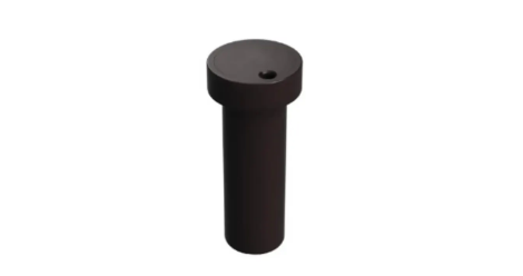
u-blox has released the LEXI-R4, a module customized for size-constrained application requirements. The device is suitable for small asset trackers, such as pet and personal trackers, micro-mobility devices, and luggage tags.
Image: u-blox
The LEXI-R4 module supports all LTE-M and NB-internet of things (IoT) bands, with an RF output power of 23 dBm. It is natively designed to support GNSS AT commands, and its dedicated port enables easy integration with any u-blox M10-based GNSS module, such as the MIA-M10.
Additionally, the module can connect to additional positioning services, such as AssistNow and CellLocate.
The compact size of the module, measuring 16 mm x 16 mm, results from a 40% footprint reduction in dimensions compared to the previous u-blox SARA-R4. Due to its small size, remaining space could host larger antennas, which can improve RF performance, or accommodate larger-size batteries.
Another feature of the LEXI-R4 is its 2G fallback capability. Whenever LTE-M/NB-IoT coverage conditions are not optimal, it continues to function by falling back onto a 2G network. The company said this feature could be helpful in countries where LTE-M/NB-IoT networks have yet to be fully deployed.
“Seen & Heard” is a monthly feature of GPS World magazine, traveling the world to capture interesting and unusual news stories involving the GNSS/PNT industry.
Bikes get tricked out
Image: Snik Bike
Snik Bike is a new app-paired tracking device designed to help users track their bikes if they are lost or stolen, reported North Shore News. Snik Bike Security Co-founder Fraser Vaage developed Snik Bike after having two of his bikes stolen. Snik equips any bike with a rechargeable location device that can be installed in five minutes or less. After pairing the device, the bike is automatically registered with Project 529, which is an online bike registration service. Vaage emphasized that while this device is not a ride-tracking software, such as Strava, it acts as an odometer, tracking overall mileage. The battery is only activated when a bike is stolen, Vaage said, therefore, it’s unlikely Snik will run out of battery. However, if it does, the device diverts to AirTag technology as a backup.
Lighthouses no more
Image: Wiltser/E+/Getty Images
With the wide adoption of GNSS, lighthouses on U.S. shorelines are no longer needed for navigation. To preserve these properties, the General Services Administration has been transferring ownership of the lighthouses to anyone willing to preserve them, reported The Guardian. This year, six lighthouses are being offered to federal, state or local government agencies, non-profits, educational organizations or anyone willing to make them publicly available for educational, cultural, or recreational purposes.
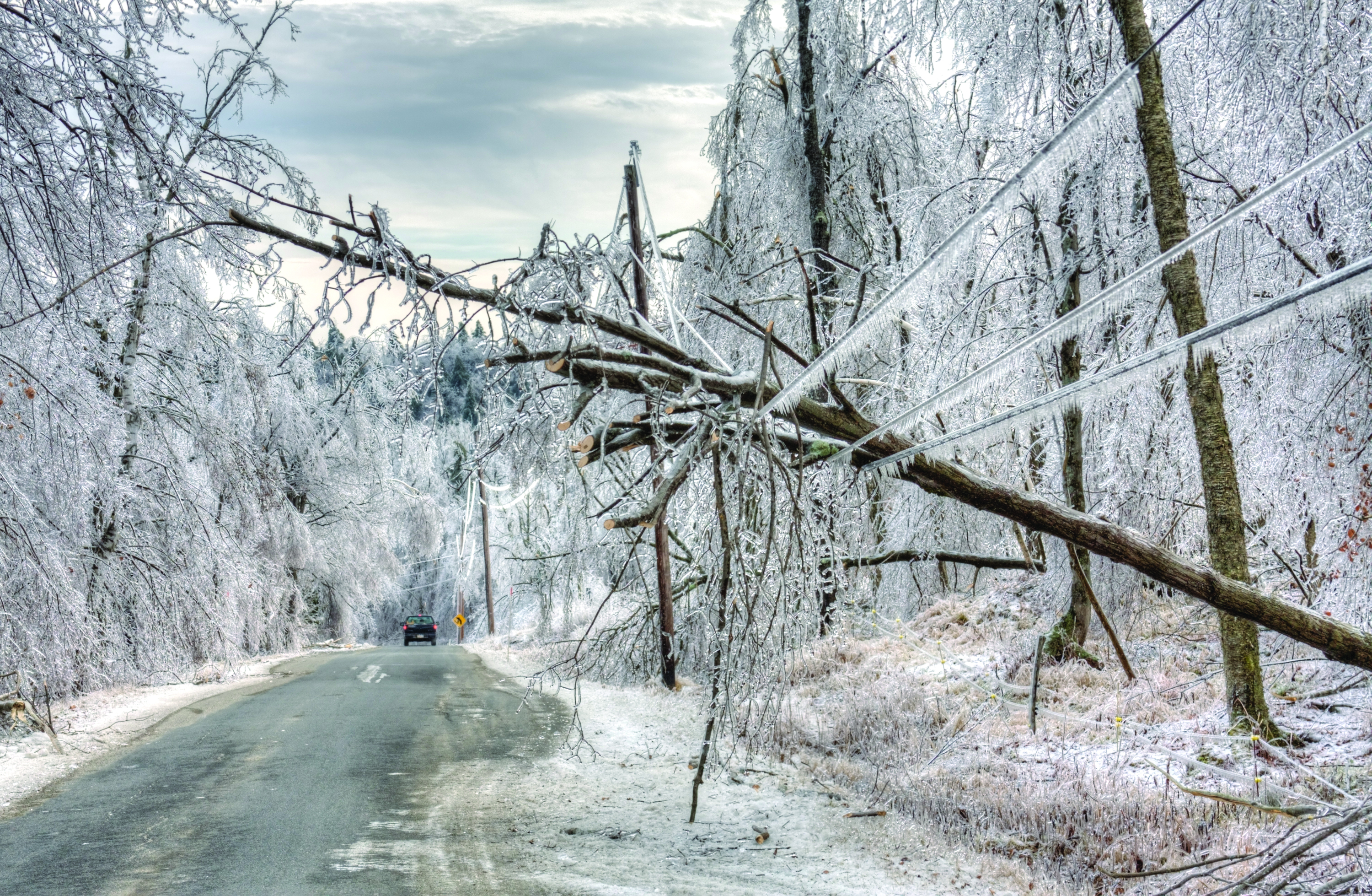
Location data ad weather resiliency
Image: DenisTangneyJr/E+/Getty Images
A Southern Methodist University research team, led by Nicos Markris, measured Dallas’ resilience by recording anonymous cell phone location data among residents in the Dallas metroplex before, during, and after the February 2021 North American winter storm. Measuring a city’s resilience is critical for planning responses to future events and uncovering potential vulnerabilities. By averaging location data, Makris and his team outlined the movement patterns of Dallas residents during a typical week. They compared the normal movement patterns to those during and after the week of the winter storm to determine when Dallas started getting back to normal.
GPS mitigates natural disasters
Image: Philip Thurston/E+/Getty Images
NASA’s Jet Propulsion Lab (JPL) is testing new ways to detect tsunami-like ocean waves before they cause catastrophic damage. The GNSS Upper Atmospheric Real-Time Disaster Information and Alert Network (GUARDIAN) is a new experimental monitoring system that can use data from clusters of GPS and other satellites to detect deadly waves triggered on Earth. Radio signals from GNSS are examined by scientific ground stations around the world. That data is then reviewed by the JPL’s Global Differential GPS network to help mitigate disasters. The GUARDIAN is still evolving and may be used in the future to develop early warning strategies, according to the United Nations’ International Committee on GNSS.
Wildfires have recently spread across Greece, Italy, Spain, Portugal, Algeria, Tunisia and Canada, causing mass environmental and economic damage as well as human casualties. Scientists have warned that wildfires are becoming more frequent and more widespread.
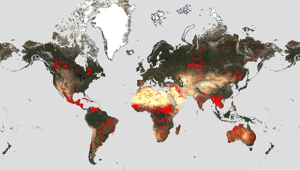
In response, an upgraded version of the World Fire Atlas from the European Space Agency (ESA) is now available. The atlas provides a detailed analysis and map of wildfires across the globe.
Rising global temperatures and the increased extreme weather has led to a surge in the number of wildfires rapidly consuming extensive areas of vegetation and forested lands.
Considering the severe wildfires, ESA has reopened its World Fire Atlas which offers an insight into the distribution of individual fires taking place at a global scale.
Through its interactive dashboard, users can compare the frequency of fires between countries as well as analyze the evolution of each wildfire taking place over time. The atlas was first available in 2019 and it supported both European civil protection agencies and firefighters.
The dashboard uses night-time data from the sea and land surface temperature radiometer (SLSTR) on board the Copernicus Sentinel-3A satellite. Working like a thermometer in the sky, the sensor measures thermal infrared radiation to take the temperature of Earth’s land surfaces which is used to detect the fires.
Data from the Copernicus Sentinel-3B satellite will be added to the atlas in December.
Over the previous seven years, data from the World Fire Atlas show a substantial number of fires detected in Portugal, Italy, Greece, France and Spain.
Data also shows that Canada has experienced 11,598 fires during the first seven months of this year alone. This is a 705% increase compared to fires detected over the same period of the previous six years. Canada is currently battling the country’s worst wildfire season on record, with more than 10 million ha of land burned, which is said to increase in the coming weeks.
The Japan Meteorological Agency (JMA) has reported that on July 10-17, data from GNSS signals indicated continuing minor inflation at shallow depths beneath Mount Ioyama, located on the northwest flank of the Karakuni-dake stratovolcano in the Kirishimayama volcano group in Japan.
Shallow volcanic earthquakes were recorded and vigorous fumarolic activity was visible at the fumarolic on the south side of Mount Ioyama. The alert level remained at two, on a five-level scale, and the public was warned to stay 1 km away from Mount Ioyama.
This JMA report was noted on July 18 in the Weekly Volcanic Activity Report, which is a cooperative project between the Smithsonian Institution’s Global Volcanism Program and the Volcano Hazards Program of the U.S. Geological Survey. The report is updated every Wednesday and averages 16 reported volcanoes.
Innoviz Technologies, a lidar technology company, and the BMW Group, a manufacturer of vehicles and motorcycles, have collaborated on a B-sample development phase for a new-generation of lidar. Under the development agreement, Innoviz will develop the B-samples based on its second-generation InnovizTwo lidar sensor to enable Level 3 automated driving capabilities.
“Lidar is one of the critical technologies underpinning Level 3 or even higher automated functions,” Nicolai Martin, BMW Group’s SVP of driving experience, said. “Optimizing lidar technologies and costs are the major challenges in order to bring Level 3 highly automated driving into the mainstream.”
The companies already have been working together for a few years on an existing program that includes the first deployment of lidar-enabled highly automated technology on the BMW 7 Series, which will launch later this year.
In addition to the lidar solution for the BMW 7 Series, the BMW Group and Innoviz have started the first phase of development for a lidar-based minimal risk maneuver system (MRM). The MRM acts as a secondary safety driving decision platform that will leverage the InnovizTwo lidar sensor to manage real-time driving decisions.
NextNav has successfully tested its positioning and timing solution that combines the company’s assured position, navigation and timing (PNT) TerraPoiNT system with existing LTE and 5G network signals. The test, which took place in San Jose, California, demonstrated how TerraPoiNT signals can be integrated with existing cellular signals to deliver accurate 3D positioning and timing information that is not reliant on GPS and GNSS signals.
Using dedicated terrestrial transmitters and LTE/5G signals, NextNav’s system delivers accurate and reliable 3D positioning and timing information and can augment or complement GPS in places where GPS signals may not be available. Integrating TerraPoiNT with LTE and 5G signals provides a rapid and cost-effective approach to scaling resilient PNT solutions in GPS-denied environments.
“Whether its utilities, banks, data centers, transportation, or emergency services, critical infrastructure today is reliant on GPS for position, navigation and timing services, making it highly vulnerable to GPS as a single point of failure” said Ganesh Pattabiraman, co-founder and CEO of NextNav. “With this integration, we have demonstrated a highly scalable and lower cost alternative — a 3D PNT solution which overcomes the vulnerabilities of GPS with a complementary ground-based resilient PNT layer that extends PNT capabilities in urban and indoor environments.”
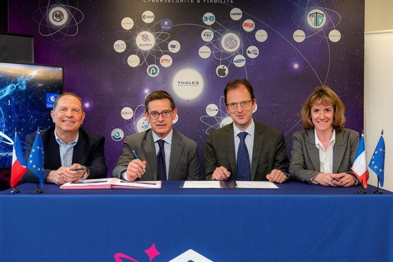
From left to right: Sylvain Loddo, director of the Galileo ground segment program at ESA, Ennio Guarino, head of the EGNOS and Galileo programs at ESA, Lionel Salmon, director of cybersecurity for information systems at Thales, and Alexandra Porez, director of cybersecurity for satellite systems at Thales. (Image: Thales)
Thales and the European Space Agency (ESA) will be working together on the cybersecurity aspects of the Galileo Second Generation (G2G) program.
Under the partnership, Thales’ scalable and flexible architecture, and security equipment will enable the G2G program to strengthen its ability to detect and respond to new cyberthreats. The end-to-end solution Thales proposed will contribute to the development of greater security and resilience of satellites.
In addition, Thales Alenia Space has partnered with the ESA to design and build the G2G ground mission segment, as well as support system engineering and technical assistance activities. The company also will provide six of the 12 satellites of the constellation.
The second-generation ground mission segment is designed to generate and connect the navigation services to the Galileo satellites and to keep the satellites synchronized with a common time reference. The first version will arrive in time for the launch of the first second-generation satellites and for the validation of the system’s in-orbit capabilities. The second version will be responsible for the missions of both the first- and second-generation Galileo satellites.
The new ground mission system, which includes several major technological innovations, will provide more than four billion users worldwide with improved performance in terms of positioning, navigation and synchronization.
Four T300’s from ComNav Technology have been used as active control GNSS points on the top of Sweden’s tallest building, Karlatornet, during its construction to deliver 3D coordinates to total stations and one was used as a base station. The building is set to be complete this month.
The T300 is a receiver with radio frequency, a baseband chip built in, and a unique quantum-real-time kinematic (RTK) algorithm. It supports full constellation systems including BDS-2, BDS-3, GPS, GLONASS, Galileo, QZSS and NavIC.
The receiver is designed for demanding surveying tasks, features tilt compensation, 4G/Wi-Fi connection, 8-GB internal memory and an easy survey workflow with Android-based Survey Master Software. It is designed to make collecting accurate data easy and fast, whether done by a beginner or experienced professional surveyor, the company said.
A report by CNBC — based on a paper published by Harvard’s’ Belfer Center for Science and International Affairs and written by Sarah Sewall — noted a growing concern that China’s BeiDou is technologically superior to GPS and serves much of the population better.
Experts in the CNBC report explained that BeiDou supports China’s military ambitions, has spurred economic growth in the country, and has increased its diplomatic leverage.
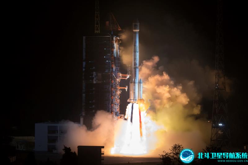
The first BeiDou satellite was launched in 2000 and served only mainland China. The system now consists of 45 operational satellites with 30 of them being the latest generation BDS-3 satellites.
Image: Bedou.gov
In 2020, China launched the last BeiDou satellite, completing the constellation. Since then, the influence of BeiDou has grown, with an estimated 1.1 billion people now using the system.
One feature in the latest BeiDou satellites is two-way messaging that is mainly available in China and requires special chips that are not widely available in the consumer market. It enables users to send short messages in areas without ground network cell coverage and can be used for search and rescue operations.
Surveillance fears
The CNBC report noted the fear that, with its enhancements, the BeiDou system could be used as a surveillance device — as the two-way messaging feature reveals a user’s locations as well as other types of data.
Additionally, with the growing number of apps for cellphones and an increase in autonomous vehicles that use the BeiDou system, more and more user data is being transmitted.
The bottom line
Satellites in the United States’ GPS constellation do not yet have those kinds of features.
There are 31 operational GPS satellites, 6 of which are GPS III satellites.
Image: GPS.gov
GPS satellite modernization
In 2008 Lockheed Martin beat out Boeing — the manufacturer of older GPS satellites — to build the GPS III satellites, the last of which was delivered in February. GPS III satellites deliver enhanced performance through a variety of improvements, including increased signal protection with improved accuracy.
GPS III SV07, SV08, SV09 and SV10 (SV stands for “space vehicle”) are awaiting launch at Lockheed Martin’s GPS III processing facility in Waterton, Colorado.
Lockheed Martin is now working on 22 GPS IIIF satellites — contracted in 2018 — that will feature more advanced capabilities. These satellites are expected to launch in 2026.
The U.S. Space Forceexercised its second contract option valued at approximately $737 million for the procurement of three additional GPS IIIF space vehicles from Lockheed Martin on Oct. 22, 2021. This contract option is for GPS IIIF satellites 15, 16 and 17 (SV15-17).
The entire fleet of GPS satellites is expected to be modernized in 2032 or 2033. However, for now, President Biden’s National Space-Based Positioning Navigation, and Timing (PNT) Advisory Board recognizes the need for a resilient national PNT architecture and acknowledges that BeiDou is technologically superior to GPS.
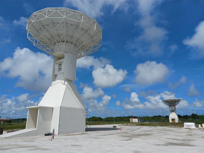
Galileo’s ground segment has gained a new asset, the Telemetry, Tracking and Control (TT&C) facility — a 13.5-m parabola dish mounted on top of a 10-m high building structure of made of steel and concrete. It is based within Europe’s launch site in Kourou, French Guiana, beside TTCF-2.
The TT&C antennas are uncrewed and operate on a fully automated basis from the two Galileo control centers located in Oberpfaffenhofen, Germany, and Fucino, Italy. The TT&C antennas are crucial to regular communication with the Galileo satellites.
This latest antenna will play an important role during the upcoming modernization activities of the earlier TT&C antennas in the station network, which have been in service for several years. TTCF-7 will take over their tasks during the maintenance activities when they need to be taken offline.
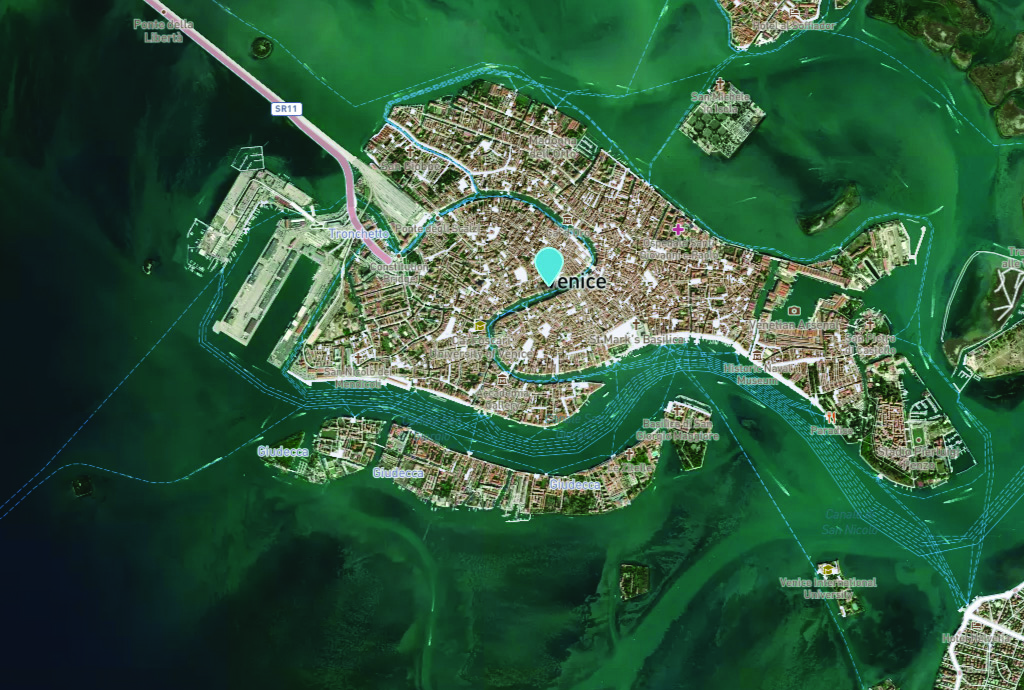
Venice arose after the fall of the Roman Empire. The city holds 450 palaces, more than 400 bridges and is home to the notable St. Mark’s Basilica. It is also known for its many canals, which are full of gondolas the way the streets of other cities are full of taxis or rickshaws. (Image: Freeartist/iStock/Getty Images Plus/Getty Images)
It is hard to believe that Italy’s “floating city” could be underwater soon.
The average rate of relative sea-level rise is 2.5 mm/year, per the European Geosciences Union’s journal Natural Hazards and Earth System Sciences. This photo of Venice from the European Space Agency (ESA) was taken in 2008 by Ikonos-2, a commercial satellite (Image: ESA)
Predictions for the future of the city vary, but most scientists agree that the sea level is rising due to climate change. Natural Hazards and Earth System Sciences, an interdisciplinary journal of the European Geosciences Union, published a report in 2021 suggesting the average sea level could be between 17 cm and 120 cm higher in Venice by 2100.
Venice was built in the middle of a shallow lagoon in the Adriatic Sea. Therefore, it has always been at risk of flooding or “acqua alta,” meaning high water. There is evidence of severe flooding dating back to around the 8th century.
The Venetian lagoon is more than 500 km2 in total, but has an average depth of only 1 m, according to Royal Museums-Greenwich. High tides and severe storms have a devastating impact on the wetland environment on which Venice is built.
Compared to the image of Venice in 2008, this U.S. Geological Survey (USGS) satellite image of Venice from May 2023 shows the rise in sea level within the past 15 years. (Image: USGS)
In November 2019, Venice experienced the second-worst flooding event in almost 100 years. The tide reached 187 cm (6.1 ft) above sea level, covering 80% of the city in water, reported the BBC.
City records show there have been 324 intense high-water events since 1872 and more than half of those have been in the past 30 years. Among the many and vast consequences of human-caused climate change may be the end of one of the world’s most beautiful cities.
1Spatial — a global provider of geospatial software and solutions for improved data governance — has launched the 1Capture, a customizable mobile application for data capture.
1Capture is a mobile GIS editing application that is multi-use and configurable. It provides accurate and reliable GIS data collection and editing in the field for a multitude of asset, job, and survey types.
Customizable rules and actions work to improve data quality at the point of capture. This ensures good quality data is captured at source, minimizing re-surveys. The built-in rules engine automatically validates and corrects the GIS and non-GIS data collected, whether working online or offline.
1Capture connects with a variety of GIS environments including Esri ArcGIS and open-source technologies such as PostGIS and Geoserver.